

sarcean
-
Posts
206 -
Joined
-
Last visited
Content Type
Profiles
Blogs
Forums
American Weather
Media Demo
Store
Gallery
Posts posted by sarcean
-
-
Not sure what I missed but the overnight models must have been disastrous for anyone not in the mountains or close to them.
-
1 hour ago, Tigerchick224 said:
That’s more along the lines of what I was thinking. I thought their first totals were a bit out to lunch.
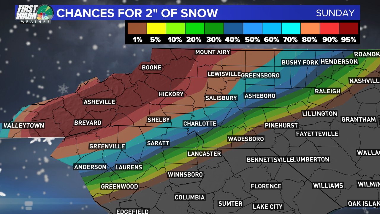
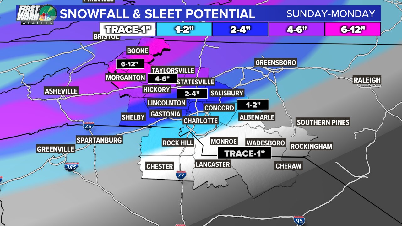
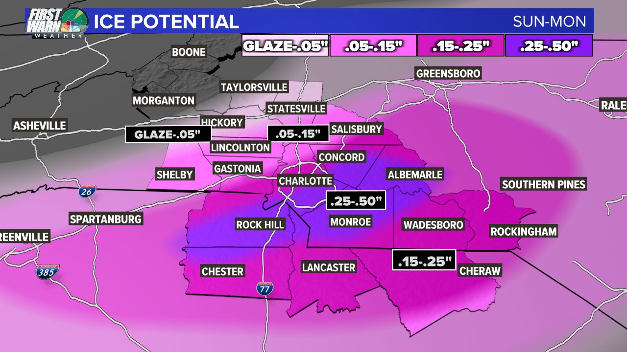
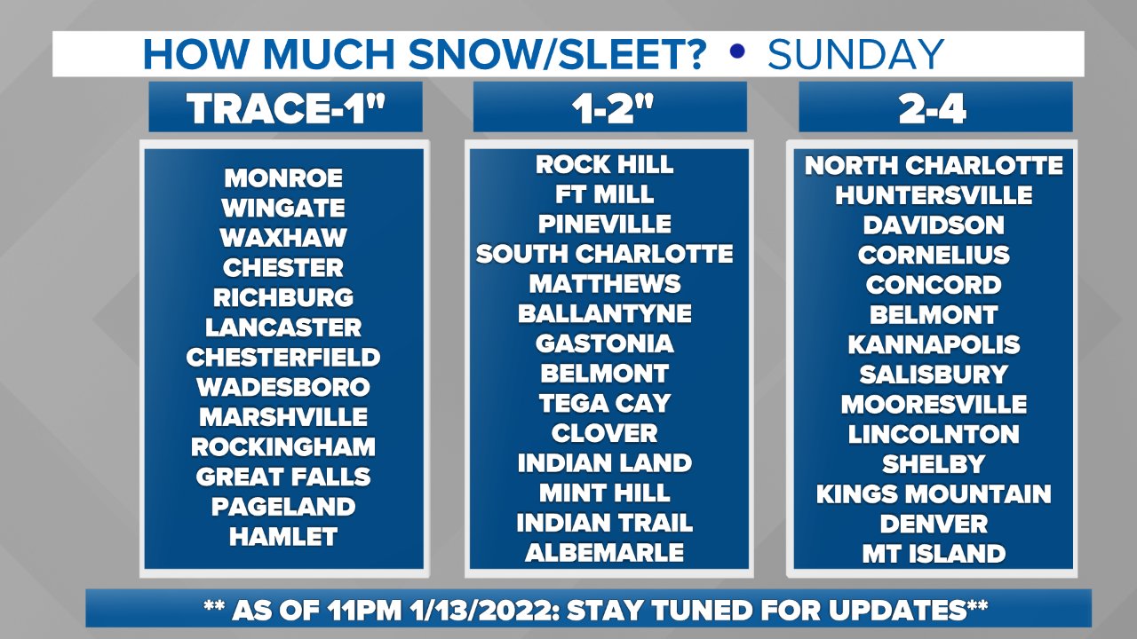
.Really disappointing map for Charlotte. An inch of snow and then atleast a quarter inch up to a half inch of ice? Suddenly the same map when viewed for High end chance for a 1 in 10 chance of 1.5 inch. Yikes. GSP is suddenly very bearish.
-
2 minutes ago, WXNewton said:
Several models seem to be picking up on a potential finger of moisture developing Saturday morning and throughout the day. I think that's something to keep an eye on, usually these big storms have that feature a half day or so before the main event. Would also keep Saturday's high temps on the lower side.
With the potential of the warm-nose and mixed-precip, every bit helps! Would be great to get snow on the front end and back end.
-
 2
2
-
-
-
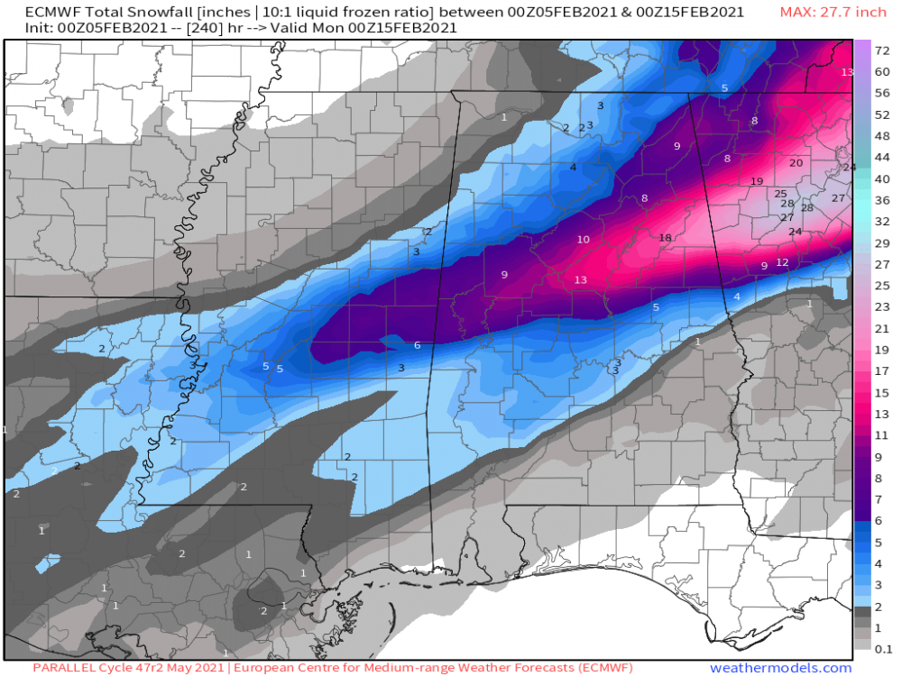
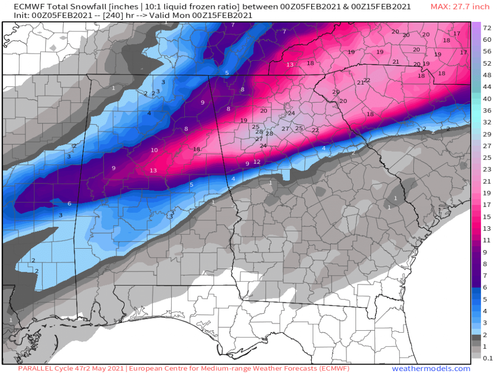
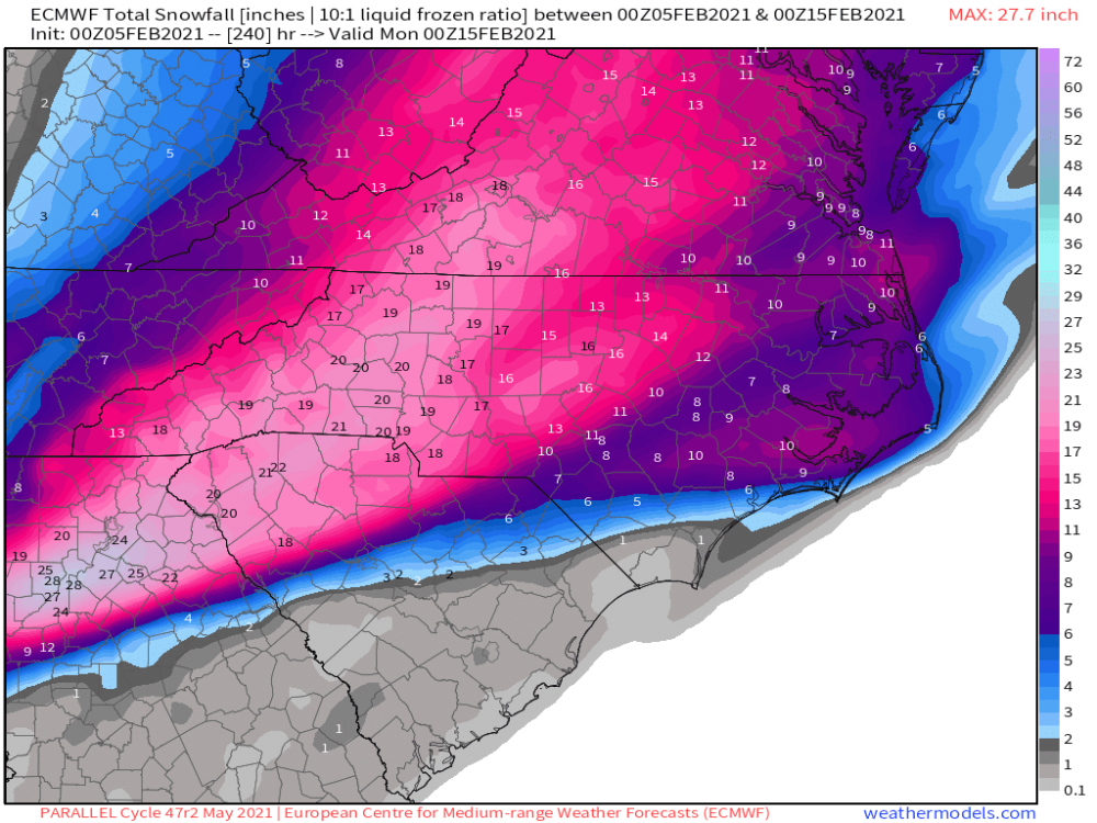
Brad Panovich's call maps
-
4 minutes ago, StantonParkHoya said:
I feel like the amount I have invested in this storm is not commensurate with what I will receive in return.

This hasn’t really been a RDU storm for days
-
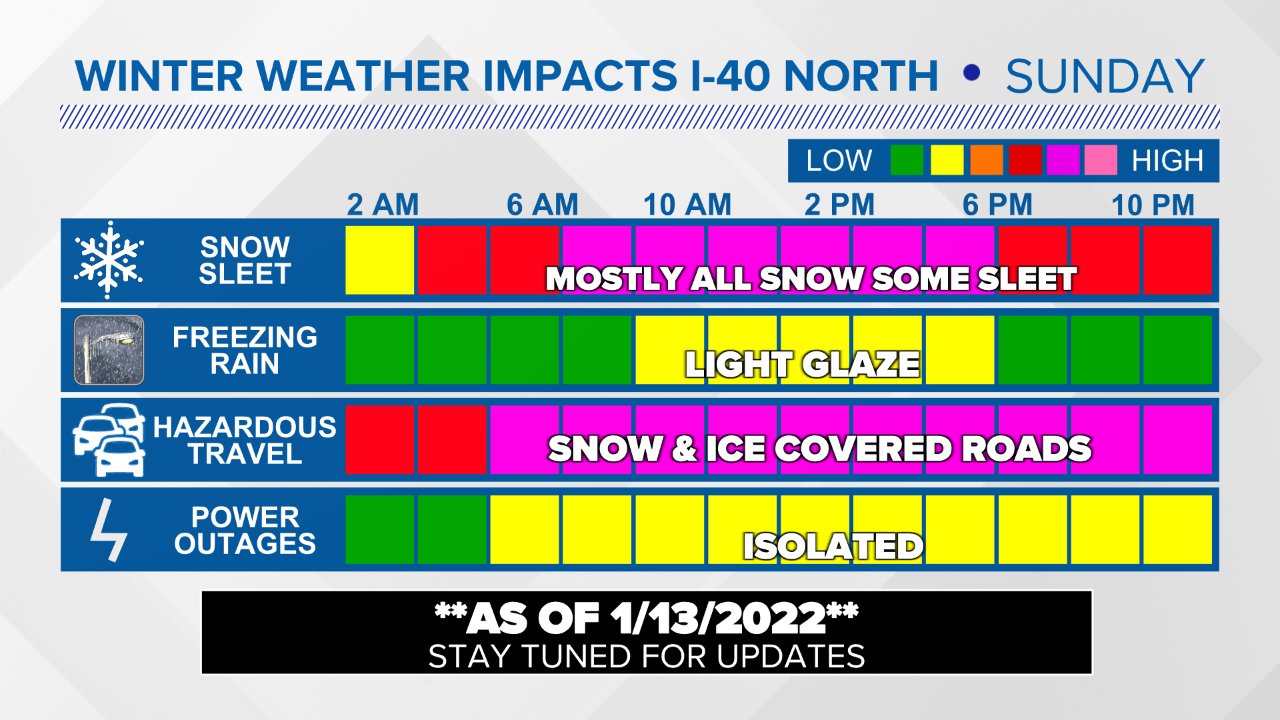
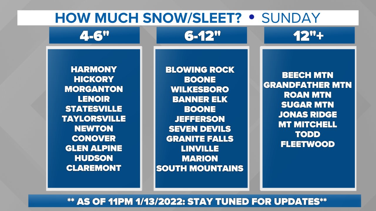
WINTER STORM WATCHISSUED: 3:39 PM JAN. 13, 2022 – NATIONAL WEATHER SERVICE
...WINTER STORM WATCH IN EFFECT FROM LATE SATURDAY NIGHT THROUGH
SUNDAY EVENING...

* WHAT...Heavy mixed precipitation possible. Total snow
accumulations of 6 to 8 inches over the northwest Piedmont, 4 to
6 inches along the I-85 corridor, 2 to 4 inches south of I-85,
and ice accumulations of around three tenths of an inch
possible.

* WHERE...Portions of upstate South Carolina, northeast Georgia
and the western Piedmont and foothills of North Carolina.

* WHEN...From late Saturday night through Sunday evening.

* IMPACTS...Power outages and tree damage are likely due to the
ice. Travel could be nearly impossible.

* ADDITIONAL DETAILS...Precipitation will begin Saturday evening
and will gradually change over to a wintry mix across the region
early Sunday morning, with mainly snow north of the I-85 corridor. A mix of all precipitation types is expected in the I-85 corridor. Freezing rain is most likely to affect the Lakelands and lower Piedmont of South Carolina, and the Charlotte metro area, on Sunday morning. Gusty winds may
contribute to power outages. The precipitation should taper off
Sunday afternoon and evening, perhaps as a period of light snow. Black ice could be a problem each morning early next week. Later guidance may affect precipitation types and amounts, and
when a Warning would be issued.

PRECAUTIONARY/PREPAREDNESS ACTIONS...

A Winter Storm Watch means there is a potential for significant
snow, sleet, or ice accumulations that may impact travel.
Continue to monitor the latest forecasts.

Stay tuned to NOAA Weather Radio or your favorite source of
weather information for the latest updates. Additional details
can be found at www.weather.gov/gsp.
-
I know we will get some snow in Charlotte but sure looks like alot of sleet, freezing, rain, and ice will mix in with it. Then when those backside winds hit it will be lights out.
-
Bad run for the Charlotte area with all that ZR
-
Just now, PantherJustin said:
You can move this to Banter if needed….. But yearly I ask this….
WNC = imo I-77 and West to TN (CLT -Winston)Central NC = I-77 - I-95 (Salisbury-GSO- Triangle)
Eastern NC = I-95- Coast (East lol)
I see ppl “Good Run for WNC” ect just wanted a board Opinion
WInston-Salem is part of the Piedmont Triad (Greensboro-High Point-Winston Salem) and very much still central NC. Charlotte is not really WNC--its more of a south central NC.
When I think of Western NC I think Anything including Hickory to the west (Asheville) and mainly the mountains. No one here in Charlotte thinks we are in western NC.
-
3
-
-
3 minutes ago, buckeyefan1 said:
Not sure if this was posted overnight

Got the Charlotte/CLT version to compare?
-
GSP Discussion:
The latest guidance suite is starting to feature a bit better agreement on the overall aspects of the winter storm likely to impact the area over the weekend. However, there remains some variation regarding low tracks, thermal profiles, and QPF for various periods, and these details continue to make precipitation types and amounts highly uncertain.
Nearly all solutions have trended toward cutting off the southern portion of the split upper flow near the lower Mississippi River Valley by late Saturday. In a slight role reversal over the past 24 hours, the ECMWF 500 mb prognostic now features a cutoff low with a farther south low center position than the operational GFS. However, both models agree fairly well on the general timing, migrating the system over the Deep/Mid South Sunday and then over the Carolinas Sunday night as the system phases back into the northern stream. Meanwhile, sprawling surface high pressure from southern Ontario to New England will establish a strong cold air damming configuration east of the Appalachians ahead of the storm on Saturday. The resulting surface-based cold layer is becoming one of the more confident aspects of the upcoming weekend storm. The onset timing of wintry precipitation, however, remains uncertain. There are hints of weak and shallow upglide developing over the preexisting baroclinic zone as early as late Friday night or Saturday morning, with the isentropic lift slowly improving the day on Saturday well east of the approaching system. The forecast features below guidance temperatures and wintry ptypes at onset across the northern half.
The period of deepest moisture and best forcing now looks slated for Saturday night through Sunday as a Deep South surface wave transitions to the Carolina coast. Strong jet-level divergence is indicated during this period and deformation zone forcing will likely impact our area by Sunday, especially over western NC given the current low track forecast. Precipitation types remain challenging. Profiles have trended to stronger warm nosing across the southern half of the area, with prolonged sleet and southern tier freezing rain now quite possible. However, the operational model runs appear warmer than most of the ensemble members, so much of the QPF could still fall as snow. An ensemble approach has been adopted for weekend profiles, which leads to more snow in the forecast than might be indicated on operational model profiles. The mixed ptype belt should especially impact locations southeast of I-85, but with a changeover back to snow likely occurring from the west throughout on Sunday night as the system pulls away to the northeast. Scattered upslope snow showers should persist along the TN border counties through Sunday night, and possibly well into Monday, further enhanching snow amounts there. We are still a bit out of the Winter Storm Watch timeframe, so this will remain highlighted in the HWO. The main change will be the addition of sleet and freezing rain to the forecast, especially across the southeast part of the area.
Another vigorous shortwave is forecast to drop southeast into the eastern trough Monday before the flow pattern flattens out by Tuesday. This could briefly reinvigorate western mountain snow showers, which may not have completely ended from the weekend system before this wave arrives.
-
5 minutes ago, buckeyefan1 said:

Happy hour is about the same and slightly delayed on the boom, otherwise niiiiiice

Charlotte would shut down for a week with that and I would love to see it
-
2
-
-
34 minutes ago, buckeyefan1 said:
RDU
")


can you post CLT?
-
Just now, SnowenOutThere said:
It has begun

-
22 hours ago, PantherJustin said:
Yea, I hate to say it..... but this may be it guys. I’m not there yet, but I’m close to saying break out the Busch light and Charcoal it’s about that time. I actually “Saw” snow fall 4x this year , it was cold and I had a small ice event last week. I will give it a C compared to last year.
I actually saw snow 0x this year in Charlotte proper. Last year was the same. Funny how much difference a 30 minute drive can make.
-
 1
1
-
-
Going to be more 35 degree rain for Charlotte it looks like
-
Models in agreement that there is lots of (relatively) cold rain coming
-
1
-
-
My older neighborhood in Charlotte is surrounded by massive pine with willow oak trees all around with atleast 20 50+ foot trees surrounding my property and backyard (with powerlines running through a line of trees) . A ice storm would absolutely devastate the area. All the established neighborhoods of Charlotte are very tree heavy.
I remember the terrible ice storm years bac in 2014 when I lived in High Point NC that knocked out power for 4+ days to most of the city.
-
22 minutes ago, wncsnow said:
The Euro does look like its trying for something past day 10 LOL
 ]
]
-
3
-
 5
5
-
-
4 minutes ago, burrel2 said:
I’ll be very, very surprised if you don’t get at least 4 inches. I’d bet the house on it.
I wouldn't be overly bullish about this. The chance of marginal temps making this a potential bust is pretty high.
-
1
-
-
1 hour ago, CustomWX said:
FWIW, the Euro Parallel continues with its bullish runs.
Even half this storm would paralyze the south (ala Blizzard of 1993). Here in NC they atleast have plows but Georgia has almost none.
-
1
-
-
1 hour ago, WinstonSalemArlington said:
Katie, bar the door!

Get ready for the snowpocalypse
-
11 minutes ago, BornAgain13 said:
That is a long duration of an ice storm in the Carolinas per 0z GFS , although with that 1062 High Pressure, a lot of that should be Snow
"In the contiguous U.S. the highest barometric reading is 1064 millibars which was measured at Miles City, Montana, on December 24, 1983"
So not impossile but extremely unlikely
-
1
-

Jan 15-16 Winter Storm
in Southeastern States
Posted
I am only a few minutes from Uptown Charlotte and absolutely surrounded by trees--my neighborhood has huge oaks surrounding every house with atleast 20+ trees within falling distance of my house. Powerlines run directly behind houses near trees, I am expecting a devastating ice storm with at the very least lost power for a few days.
About to book a cabin in the high country near Boone and atleast enjoy some good snow.