

sarcean
-
Posts
251 -
Joined
-
Last visited
Content Type
Profiles
Blogs
Forums
American Weather
Media Demo
Store
Gallery
Posts posted by sarcean
-
-
3 minutes ago, eyewall said:
$297 on Kayak.com for direct JetBlue to BOS from RDU in case anyone was wondering.
I remember being up in Snowshoe, WV for the Jan 2016 blizzard when they got three feet of snow. The first foot was great...it was after the second that it started getting ridiculous.
-
 2
2
-
 1
1
-
-
-
Snowing great in uptown Charlotte! Maybe a couple inches on the ground.
-
1
-
-
2 minutes ago, Brick Tamland said:
It's not really each model run, though. The storm has trended worse and worse today with each model run after just looking awesome 12 hours ago, and only 48 hours before go time. Sorry, but that is an epic collapse by the models.
No one has whines as hard as you on these boards. You will get snow. It may not be as much as some models had but the triangle is going to get over an inch to several inches which is a win anytime.
-
1
-
-
3 minutes ago, wncsnow said:
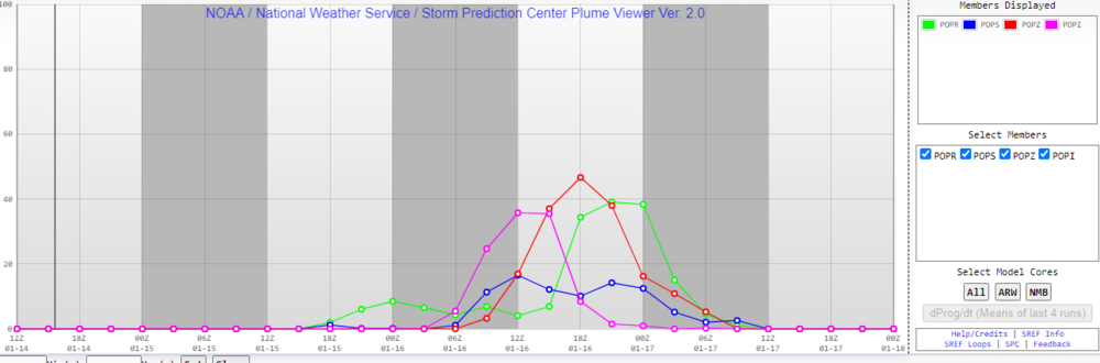
RGEM, its still snowing too
(3).thumb.png.f03a87dcc44e54fa3ef134e42220ca8f.png)
Ready to cash out with that one
-
Here is hoping Charlotte can score decently with this setup with atleast a few inches
-
3
-
-
Getting some insane winds keeping me up. Easily gusts over 50mph with white out conditions which is very loud blowing all the snow around. Waiting for a tree to come down
-
Black Mountain a little higher up has been getting quarter sized flakes for well over an hour now. No evidence of the few times I have been outside as it all had been covered.
completely dumping right now
-
In Black Mountain it’s been dumping quarter sized flakes for well over an hour now
-
1
-
-
Got some flurries in Black Mountain but temps are still much to high in the mid 30s
-
6 minutes ago, weatherbo said:
Who here is above 4000'?
Staying at a cabin over 5000’ tonight.
-
2
-
-
21 minutes ago, BretWx said:
These potential gusts right after the heaviest rates move through Phew!

Lights out for those with ice
-
1 minute ago, NavarreDon said:
It’s basically go time now. Model watching is about over. If I was up there I’d be looking at the strength & placement of the HP & watching the track, speed of the developing LP.
.Still about 12-13 hours to real go time but it’s getting there.
-
The Charlotte area is going to be hit really bad by ice. There could be a few hundred thousand without power if it verifies. Most of the older neighborhoods of the city close to the urban core are extremely tree filled and it won’t take many of them to cause a large disruption for days.
im going to ride this one out in Black Mountain near Asheville where I can enjoy a all essentially all snow event and not deal with ice and power loss.
-
Riding this one out in Black Mountain. Feeling good that it will be atleast a foot when it is all said and done! NWS is saying 10-17.
-
1
-
-
Just now, buckeyefan1 said:
I see the euro held serve


mind posting CLT? Thanks!
-
27 minutes ago, snowmaker13 said:
People need to prepared for significant power outages in the piedmont


If that holds up that looks catastrophic to Charlotte
-
I am only a few minutes from Uptown Charlotte and absolutely surrounded by trees--my neighborhood has huge oaks surrounding every house with atleast 20+ trees within falling distance of my house. Powerlines run directly behind houses near trees, I am expecting a devastating ice storm with at the very least lost power for a few days.
About to book a cabin in the high country near Boone and atleast enjoy some good snow.
-
Not sure what I missed but the overnight models must have been disastrous for anyone not in the mountains or close to them.
-
1 hour ago, Tigerchick224 said:
That’s more along the lines of what I was thinking. I thought their first totals were a bit out to lunch.
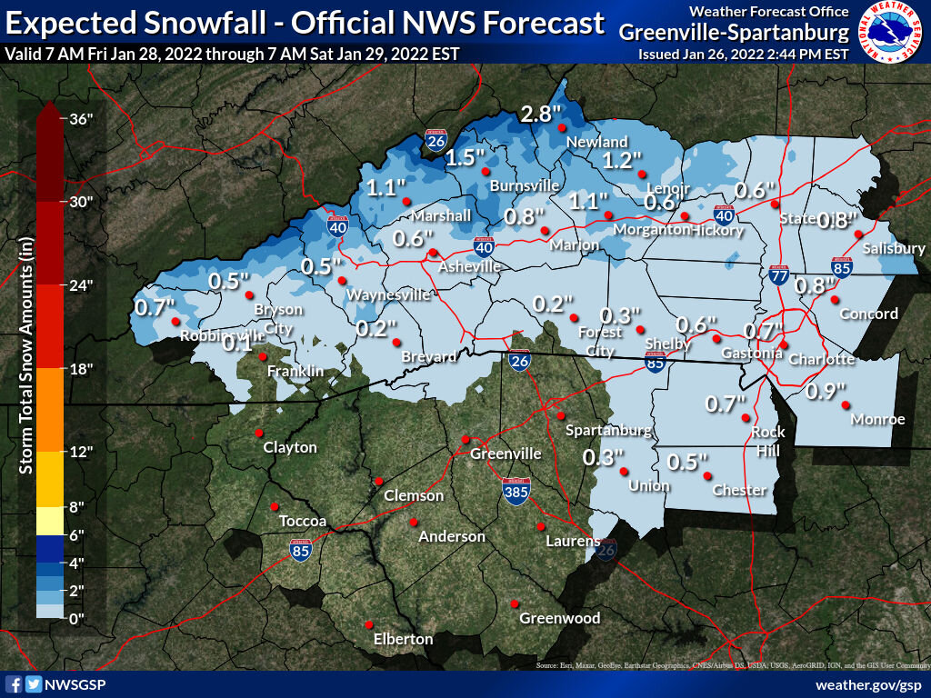
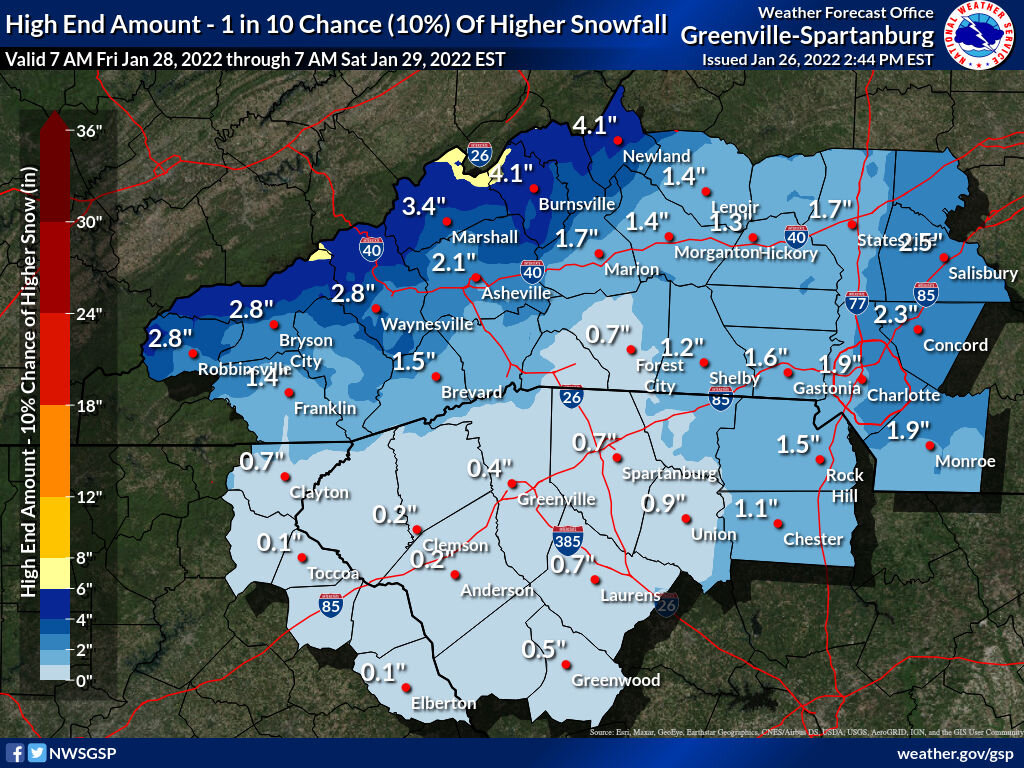
.Really disappointing map for Charlotte. An inch of snow and then atleast a quarter inch up to a half inch of ice? Suddenly the same map when viewed for High end chance for a 1 in 10 chance of 1.5 inch. Yikes. GSP is suddenly very bearish.
-
2 minutes ago, WXNewton said:
Several models seem to be picking up on a potential finger of moisture developing Saturday morning and throughout the day. I think that's something to keep an eye on, usually these big storms have that feature a half day or so before the main event. Would also keep Saturday's high temps on the lower side.
With the potential of the warm-nose and mixed-precip, every bit helps! Would be great to get snow on the front end and back end.
-
2
-
-
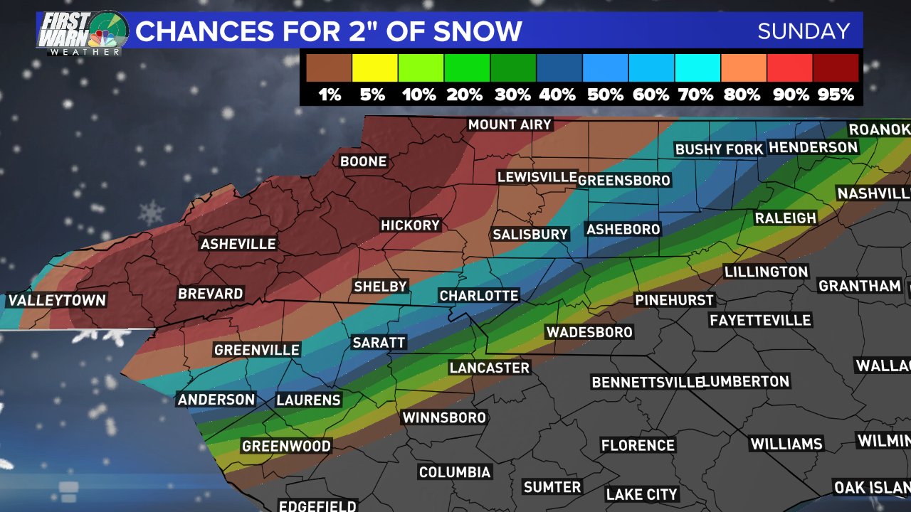
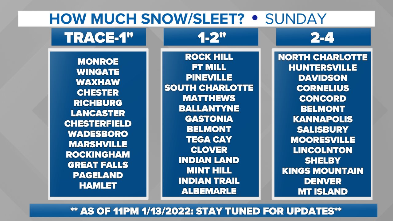
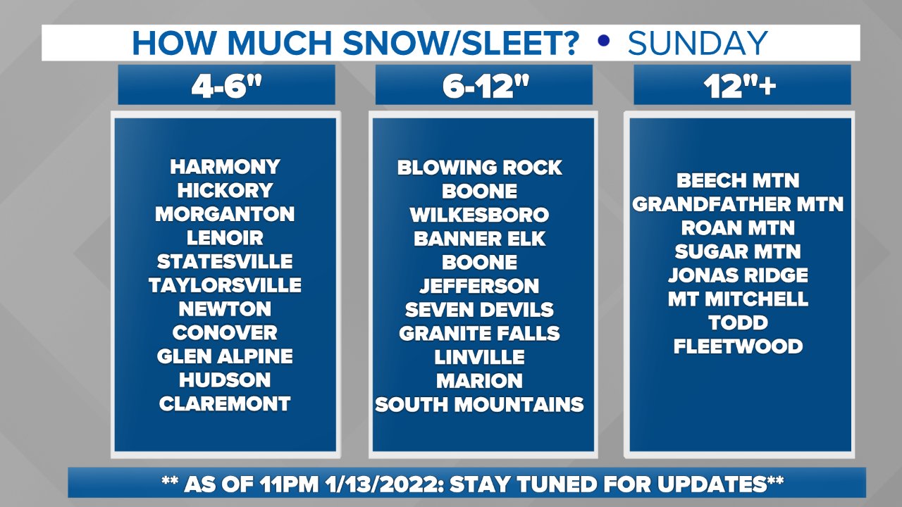
-
Brad Panovich's call maps
-
4 minutes ago, StantonParkHoya said:
I feel like the amount I have invested in this storm is not commensurate with what I will receive in return.

This hasn’t really been a RDU storm for days
(3).png.755e8bda3e31d2f065951d7fdc2b10b6.png)

Potential 1/28-1/30 2022 winter storm
in Southeastern States
Posted
If we some how in Charlotte pull 2"+ from this I would consider that a big win