

JasonOH
-
Posts
791 -
Joined
-
Last visited
Content Type
Profiles
Blogs
Forums
American Weather
Media Demo
Store
Gallery
Posts posted by JasonOH
-
-
The cars that were pushed into the basement may have been a factor in the collapse. Could be EF4 but NWS will definitely consider whether those cars contributed to the collapse.
-
-
-
1 minute ago, MUWX said:
I don’t totally understand why the SPC tries to estimate the intensity of ongoing tornadoes in MDs
There is research that shows it can be estimated by VROT and CC depth. My friend does research on it and posts some stuff on twitter. He will probably be posting about this tor at some point.
-
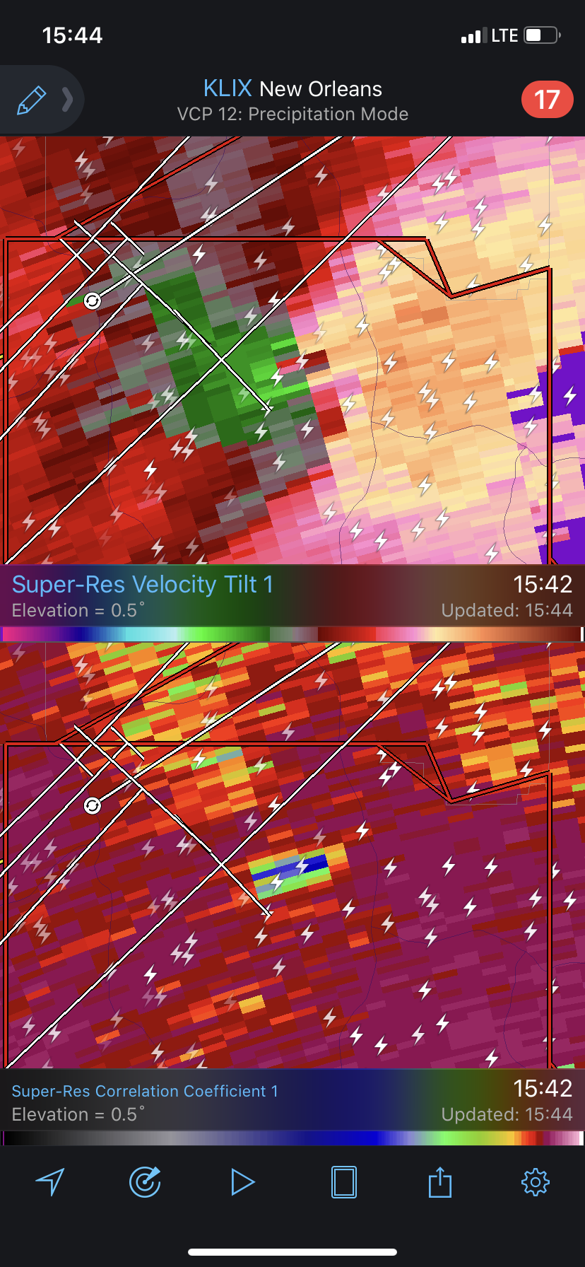
Here’s the CC drop.

-
McComb, MS storm is moving hard right. Looks like it will move directly toward Hattiesburg.
-
5 minutes ago, Indystorm said:
I think Quincy somewhere back in this thread said something to the effect that you don't need low level lapse rates to be great if other parameters are off the charts.
You don’t need low level lapse rates typically, but if there’s a cap storms won’t get organized if they even initiate. In this case we need them to overcome the cap that’s evident in the 18z JAN sounding.
-
2 minutes ago, janetjanet998 said:
That actually isn't a debris signature here. It is over clear air and any CC drop not correlated with a circulation and dbz<40, so that specifically isn't debris.
-
Absolutely nuts to see this many QLCS tors ongoing.
-
1 minute ago, DanLarsen34 said:
That radar signature is suggestive of at least an EF-3. Yikes.
Not necessarily. The TDS doesn’t look very tall since it’s not even visible from the fort Polk radar at 7k feet. It could be EF3+ but sometimes radar signatures are deceiving.
-
 1
1
-
-
A great thread by a friend of mine talking about the OK portion of the severe threat tomorrow.
-
This is a great twitter thread about tomorrow and dynamics in general.
-
1
-
-
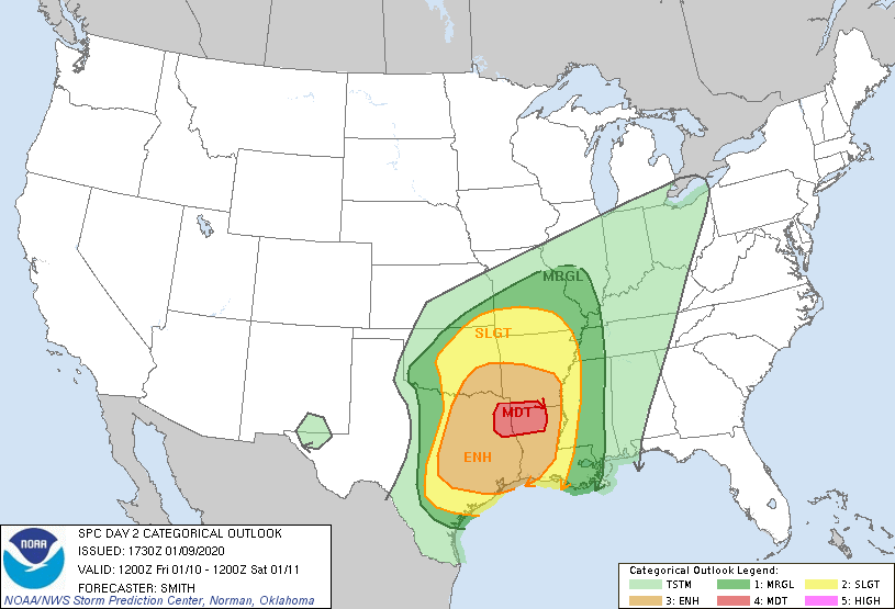
45% Sig Wind driven Moderate for tomorrow.
-
Mean wind isn’t on the hodograph (In that sounding) so storms should naturally turn right. The VBV doesn’t necessarily inhibit tornado genesis unless it’s below 750mb. I have noticed that on a lot of violent tornado days there is a bit (not a ton) of VBV at just above 700mb.
-
What BMX said is very true. The QLCS comes through too early Saturday for heating to be maximized with current timing so warm sector updrafts may not be robust enough to survive. This a could result in a very impressive QLCS and I personally think (Currently) damaging winds/embedded tors are the greatest threat Saturday.
-
One thing to keep an eye on is the mean wind being very close to or on the hodograph. That will cause storms to have trouble turning right and starting to strongly rotate.
-
1
-
-
A larger wind field will also contribute to more upslope flow overall. This extra lift will increase the flood threat inland.
-
Something to note with the CC drop:
-
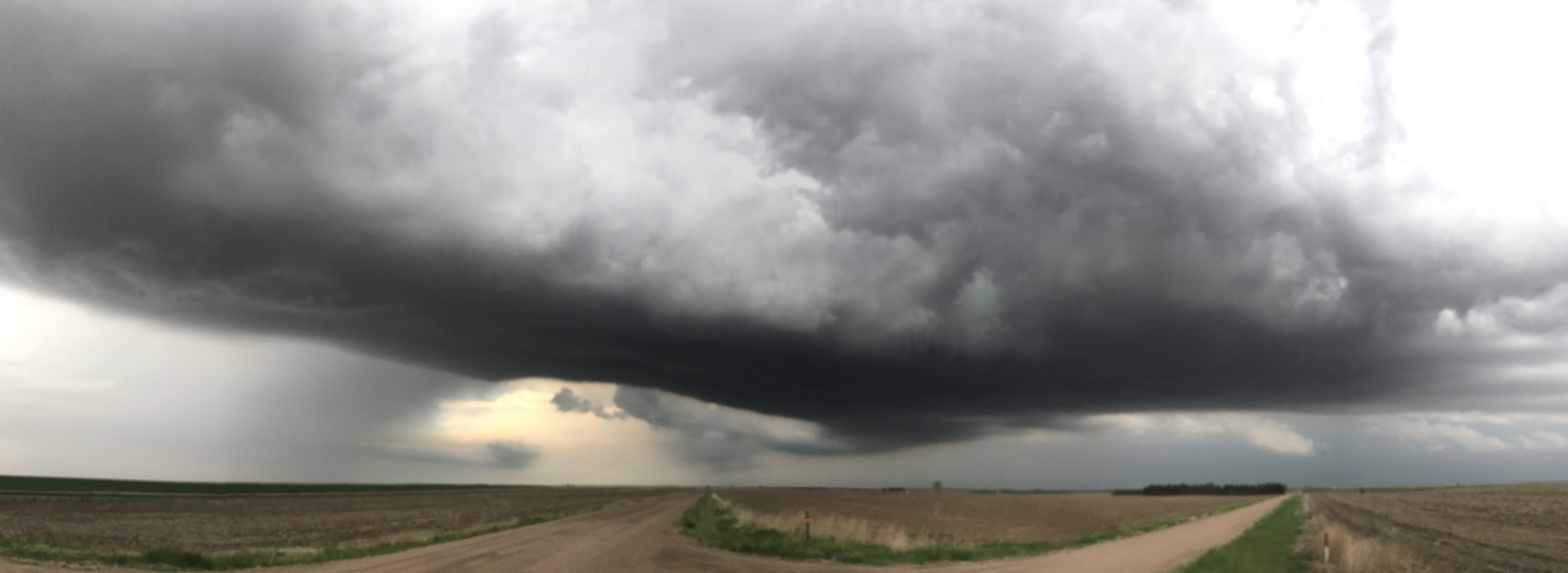
Today went way better than expected. We were on the storm that sat over Quinter, KS from when it first broke the cap. We about dumped it to drop back and it went nuts. We sat back in one of the most amazing RFD clear slots I’ve ever seen. It tried to tornado but bases were too high. We did get a landspout in the RFD though.
We had to bail south during a massive RFD surge to dodge the baseball sized hail. Overall the storm was awesome and vastly exceeded expectations. Spending the night in Salina and back to chasing again tomorrow!

-
1
-
-
8 minutes ago, ice1972 said:
TDS in NW CT?
Nope. While it was close to the area of the couplet the CC drop was all in clear air. General rule is that it’s correlated with the couplet and reflectivity>50dBZ in the CC drop bins to be debris.
-
Latest center dropsonde had 933mb with 25kt winds. Pretty nice west wobble between the last 2 passes. Tropical Tidbits isn't plotting rain rate and SFMR. Not sure if it's a data problem or an aircraft problem. The southern eyewall is very weak compared to the northern side with FL winds ~35 knots slower.
There is no secondary wind max showing up. This leads me to believe that the weakness is due to the mountains of Dominica, not an ongoing ERC. It should work out as the day goes on.
-
1
-
-
Just now, MikeB_01 said:
Is there a reason why the recon flights won't fly into the eye while its over land?
Turbulence is a major issue over land. Also, over land terrain interaction is a risk. It's a common policy for them to not fly in over land. In this case it's even more of a terrain issue than usual due to the 4500foot peaks on the island.
-
5
-
-
Raw T# up to 7.1 per CIMSS. Anyone have their link for the GOES-16 ADT?
-
8 minutes ago, jojo762 said:
So, you're just going to ignore a dropsonde then that measured 140mph at the surface and 160+mph just above the surface?
Yes. In the last 4mb the wind speed increased, indicating it was a gust. 4mb above the surface it was 112kt. At 5mb above the surface it is 117kt. With friction this is likely 110kt at the surface. You can't take the dropsondes verbatim every time since this one shows a pretty classic signature of a gust.
April 12 Severe Event
in Southeastern States
Posted
I’m going with not at all well built. I see strait nails on the bottom right and it looks like the whole thing is on cinder blocks not anchored to the ground in any way. I don’t see a concrete pad anywhere in the higher res image. There’s a chances they only rate it EF3 depending on the evidence on the ground.