

JasonOH
-
Posts
791 -
Joined
-
Last visited
Content Type
Profiles
Blogs
Forums
American Weather
Media Demo
Store
Gallery
Posts posted by JasonOH
-
-
Sure doesn’t look good now.
-
The band is back and as soon as it showed up the whole thing got super ragged again. Not looking great right now.
-
 1
1
-
 1
1
-
-
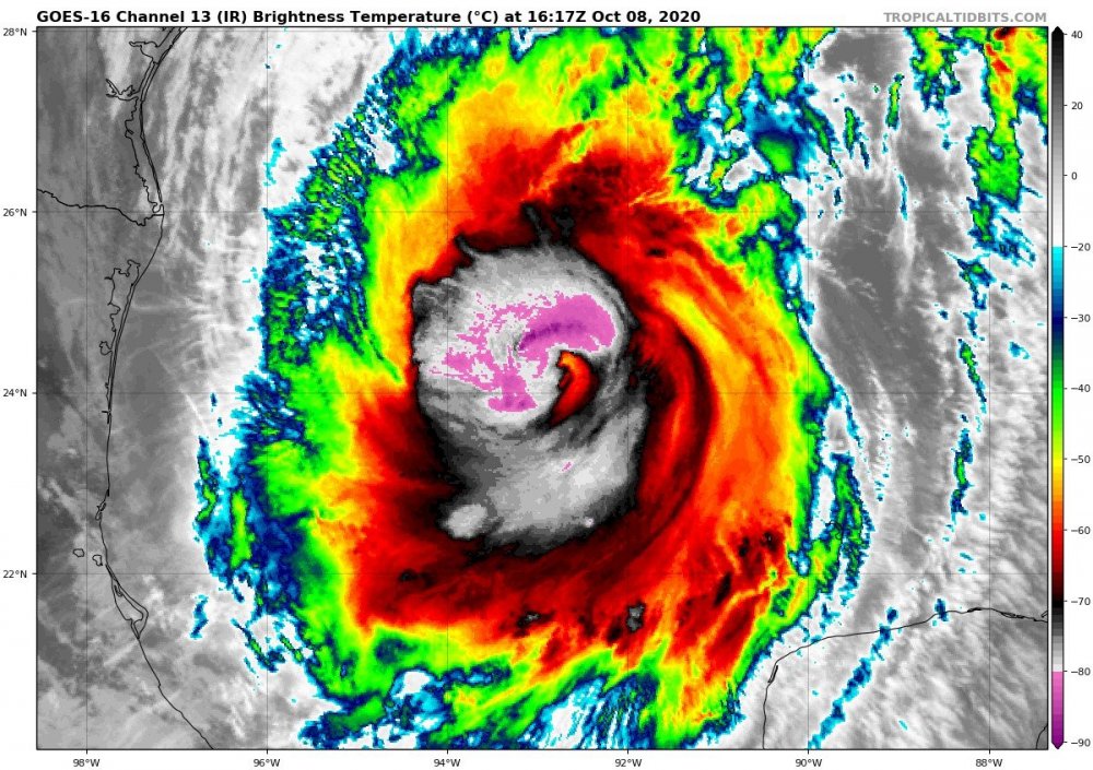
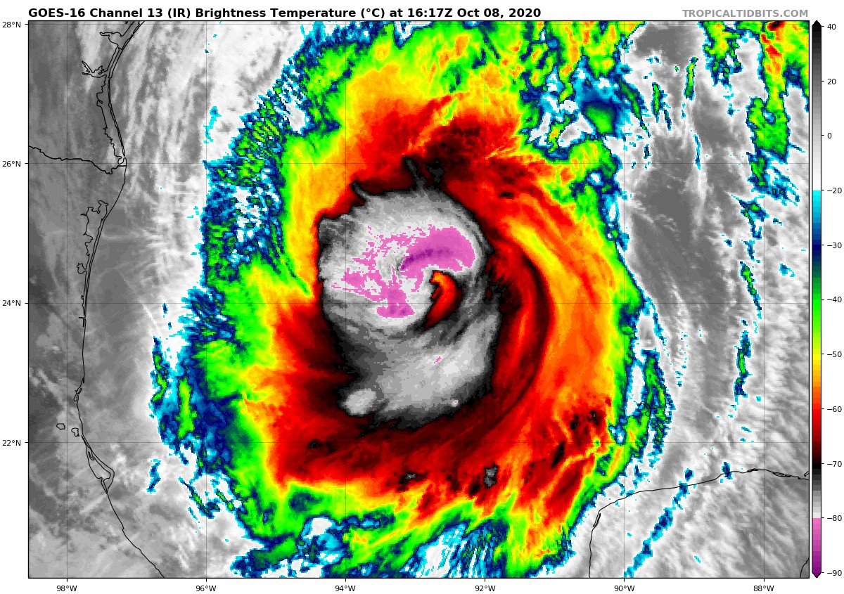
Latest VDM still showing open eyewall. Based on IR it looks like there’s a weaker area rotating around that was to the south a couple minutes before the VDM. It’s now on the east side but looks a bit better now.
edit: that lasted like 10 minutes
-
Looks like there’s currently 2 hot towers rotating around the center. May get some inner core organization going finally.
-
 2
2
-
-
6 minutes ago, StormchaserChuck! said:
ERC.
I don’t think it’s an ERC since the eyewall never really has been stable yet. I think it’s more due to the fact that there isn’t a super strong eyewall so the wind max isn’t as concentrated.
-
2
-
-
It's back to open SW on latest VDM.
-
From VDM:
F. CLOSED
G. C30
TLDR: Eye is closed. 30nm diameter
-
 1
1
-
-
3 minutes ago, Moderately Unstable said:
Sock puppet eh. What show do I star in? I can't wait for my reviews! Based on the last couple of days, RI may be relative. What was seen a couple of days ago was voracious and unusual. We should, based on the recent imagery coming in, expect I. The guidance says we should see more intensity, the microwave and IR imagery is improving, the above post referenced by Windspeed and JasonOH was in particular an "oh, well then", moment. I am taking the same approach as the NHC likely is about to right now, in not jumping the gun and rapidly changing their thinking. Hours back, folks were saying, it may be a 1! What a joke! etc. We can't swing 1-4-1-ts-4-5!. I still think a cat 3 peak is the most likely scenario. Big cat 3, maybe upper end cat 3, with extensive surge impact. But right now I go mid cat 3. Outflow does look a lot better, and historical context suggests good outflow is key in terms of sustaining and maintaining a clean core, which appears, again above, to be developing. To the two earlier posters who said the nice things welcomed me--thank you :). It is nice to have a place to discuss weather without being looked as though I have three heads.
MU/CD
Pretty much right on with what I’m thinking. You’ve made some excellent posts with this storm. Great stuff.
-
3
-
1
-
-
968.8mb extrap, 94kt flight level, 69kt SFMR on the inbound.
-
Air Force recon is heading in right now and NOAA is right behind. Double recon this evening!
-
11 minutes ago, Windspeed said:
Umm.. That didn't take long.

Perfect timing for that pass. Pretty much confirms what I was seeing on IR.
-
Hot tower is wrapping around the north side of the circulation now.
-
In the last few frames the line of overshooting tops appears to be taking on a bit of a curved shape with the east end rotating north. May be getting some organization
-
963.8 extrap on that pass. Previous pass VDM noted an eyewall open to the north. Improvement over previous structure where there was no coherent eyewall.
-
No eyewall noted on VDM.
-
Eyewall looks much improved on the last few scans from the Cayman Islands. It’s 175+nm away but the eye appears to be 10-15nm wide. Also, recon just took off. Should arrive near 0z.
-
1
-
-
Anyone have the recon plan of the day for today? They updated tomorrow’s plan so the plan for today no longer comes up on the NOAA site.
-
Interesting radar loop from the Cayman Islands. It’s super far from radar but it looks like there *may* be an EWRC in progress/finishing up.
http://www.weather.gov.ky/portal/page/portal/nwshome/forecasthome/radar
-
1 minute ago, Doc Jon said:
Whoops. Misinterpreted what kind of fusion you were talking about. Thought you were referencing lightning for some reason.
-
Another reminder, MIMIC doesn’t update without additional polar satellite passes. With a storm that’s rapidly evolving (like this) and with the latest pass being 8 hours ago, it’s useless.
-
FWIW the energy from fusion due to lighting is orders of magnitude lower than that of the storm as a whole and has no effect on strengthening. It’s a symptom of strengthening and microphysics processes, not a cause.
-
VDM went in as 957mb. Drop had 957 with 25kt wind though.
-
2 minutes ago, Snowstorm920 said:
Might have some twins
The eastern circulation is side lobe so there aren’t twins. It’s centered over the inflow region, not the hook.
-
3
-
-
Gotta love the long range HRRR and it’s propensity to do crazy things.
Major Hurricane Delta
in Tropical Headquarters
Posted
FWIW I usually put much more stock in IR since it allows me to see finer detail than visible on cloud heights. Allows me to pick up different features that may not be as well shown on vis.
in other news, recon got 102kt flight level NE of the eye.