JasonOH
-
Posts
791 -
Joined
-
Last visited
Content Type
Profiles
Blogs
Forums
American Weather
Media Demo
Store
Gallery
Posts posted by JasonOH
-
-
10 minutes ago, the ghost of leroy said:
What’s the raw T?

5.1
-
2 hours ago, wkd said:
He said it NEARLY stalled.
I even find that unlikely. I don’t think that dude is a good source at all. If that was the case I would have heard about it by now.
-
I think the reported 8 mile eye was the decaying inner eyewall. Based on satellite imagery you can see the old eye rotating around the eyewall.
-
Based on flight level obs I think that’s just a gust. Flight level obs have never had a wind speed greater than 130kt this mission. Also, there is usually decrease in wind speed in the lowest 20mb and that isn’t the case in that sonde. The only value that’s Cat 5 is the surface wind, nothing else. Mean wind in the lowest 150m is more useful in this case and that’s still Cat 4.
-
2 hours ago, Crocodile23 said:
This is from a post on twitter.
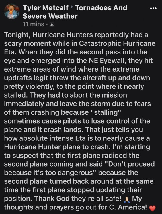
We can speculate (like I did above), but I don’t think that kid is a good source. It’s likely extreme turbulence made it unsafe, but I find it unlikely it went so far as stalling.
-
2 minutes ago, SnowLover22 said:
what makes flying through mesovorts even more dangerous than the eyewall itself?
Wind shear. Rapid onset of wind shear can result in high G loads (and turbulence). The eyewall is pretty homogenous and there isn’t actually that much shear since it gradually ramps up. The mesovorts have wind directional and speed changes that happen exceptionally fast.
-
 1
1
-
-
Just now, Moderately Unstable said:
That is quite possible actually, perhaps likely.
The biggest thing that makes me think that is the timing of the aborts being almost identical. With that tiny of the eye it will be very hard to avoid the mesovorts. I'm thinking the turns around the eye were to time the exit to avoid mesovorts.
-
I wonder if the abort was due to the mesovorts. They may have decided it was too dangerous.
-
2
-
-
127kt FL with 135kt unflagged SFMR (Press x to doubt). 925.3mb extrap on the last ob.
-
1
-
-
1 minute ago, NorthHillsWx said:
For the convo about best looking storms we forgot a relevant one in this region: Mitch at peak
This will have similar effects too: tons of rainfall causing catastrophic flooding.
-
Raw T up to 8.4 per UW CIMSS. This may look perfect but it takes time to deepen. If there's a large drop between passes I think we make a run at 900mb overnight. If there is not a large drop then I think this will max out at 915-920mb
-
1
-
-
Just now, Moderately Unstable said:
It feels like the entire site is on this thread. 116 members are currently viewing this. How many guests? 1000? I sure am glad to have something else to focus on right now to, ya know, what's going on right now. The north eyewall reported a minimum pressure of 929mb. This likely means the central pressure is 923-925mb.
That north eyewall didn't have a surface report though. We only know the last report was at 929mb before it cut out.
-
I think there is a secondary eyewall forming. There's a bit of a secondary SFMR max on the inbound. On the outbound there is a big rain spike at about the same distance radially from the center.
-
Just a friendly reminder that storms need time to deepen. No matter how good it looks you can't drop 100mb in a day.
-
3
-
-
The pressure was extrapolated from 700mb. I guess they either ran out of dropsondes or had a malfunction. That explains why the VDM came out so quick. Eye diameter down to 20nm with the south side open.
-
Jesus they got that VDM off super quick. 950mb
-
Just now, 1900hurricane said:
Oh hey, that's me!
Never realized that was you. You tweet some real good stuff!
-
9 minutes ago, SnowLover22 said:
um.....

Took me a couple tries to get it to work on my iPhone. Site isn’t designed for super good public consumption. Y’all got lucky I have a friend with the link.
-
1
-
-
3 minutes ago, Moderately Unstable said:
Yes, it has been for hours in Brownsville. It's only so useful at the 248nm range. You can't see the velocities, not that that would be super helpful given the elevation you'd be at at that distance. I wish the mobile doppler coming in from OU would be integrated into the nws system so we could see it live, but I don't think that's possible. If I'm wrong and someone knows about that please feel free to chime in. Latest pressure in the eye reported by the way, 955mb.
This link should have the OU SMART-R feed it once they are set up:
http://smartr.metr.ou.edu/smartr2/latest/
*deleted previous post since I got the link.
-
 1
1
-
-
949.2 extrap. 95kt FL and 95kt SFMR on the inbound.
Edit: Large area of 100kt FL on the outbound.
-
1
-
-
SFMR gets messed up in high rain rates. Those low values were all right in the middle of a huge rain rate spike. Dropsonde should give us a better idea of what’s going on since SFMR couldn’t that pass.
-
2
-
-
Outflow looks good in all quadrants. Based on what I’m seeing right now I expect recon to find ~115-120kt FL and ~100KT surface. Low end Cat 3.
-
2
-
-
Had to get some work done and took a bit of time off from the storm. Looks a bit improved in the past hour. Slow intensification is definitely happening.
-
Got up to 110kt flight level that pass.


MO/KS/AR/OK 2020-2021 "Winter" Discussion
in Central/Western States
Posted
My best estimate of total snowfall in Wichita Falls is 6.5”. With how much wind we had it’s hard to get an accurate number, even in areas protected by the wind.