
JasonOH
-
Posts
797 -
Joined
-
Last visited
Content Type
Profiles
Blogs
Forums
American Weather
Media Demo
Store
Gallery
Everything posted by JasonOH
-
This link should have the OU SMART-R feed it once they are set up: http://smartr.metr.ou.edu/smartr2/latest/ *deleted previous post since I got the link.
-
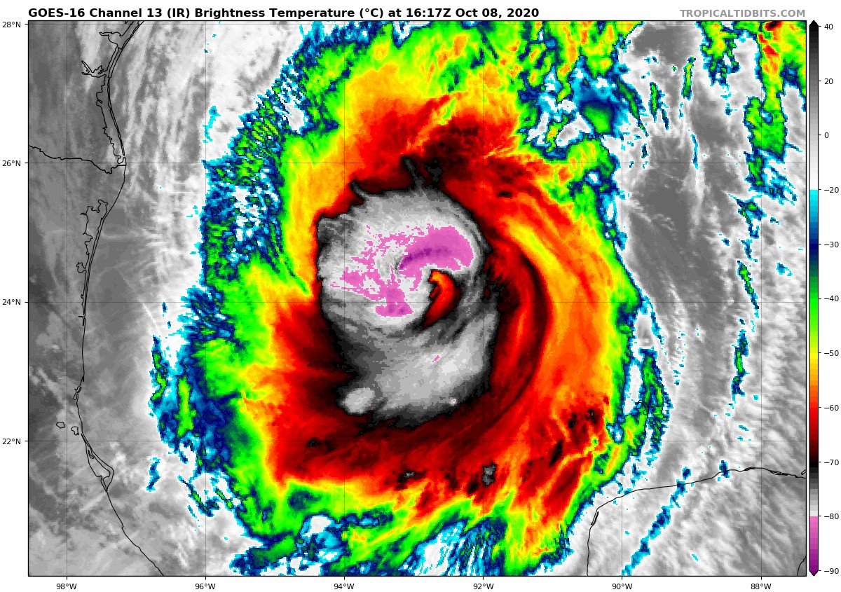
949.2 extrap. 95kt FL and 95kt SFMR on the inbound. Edit: Large area of 100kt FL on the outbound.
-
SFMR gets messed up in high rain rates. Those low values were all right in the middle of a huge rain rate spike. Dropsonde should give us a better idea of what’s going on since SFMR couldn’t that pass.
-
Outflow looks good in all quadrants. Based on what I’m seeing right now I expect recon to find ~115-120kt FL and ~100KT surface. Low end Cat 3.
-
Had to get some work done and took a bit of time off from the storm. Looks a bit improved in the past hour. Slow intensification is definitely happening.
-
Got up to 110kt flight level that pass.
-
FWIW I usually put much more stock in IR since it allows me to see finer detail than visible on cloud heights. Allows me to pick up different features that may not be as well shown on vis. in other news, recon got 102kt flight level NE of the eye.
-
Sure doesn’t look good now.
-
The band is back and as soon as it showed up the whole thing got super ragged again. Not looking great right now.
-
Latest VDM still showing open eyewall. Based on IR it looks like there’s a weaker area rotating around that was to the south a couple minutes before the VDM. It’s now on the east side but looks a bit better now. edit: that lasted like 10 minutes
-
Looks like there’s currently 2 hot towers rotating around the center. May get some inner core organization going finally.
-
I don’t think it’s an ERC since the eyewall never really has been stable yet. I think it’s more due to the fact that there isn’t a super strong eyewall so the wind max isn’t as concentrated.
-
It's back to open SW on latest VDM.
-
From VDM: F. CLOSED G. C30 TLDR: Eye is closed. 30nm diameter
-
Pretty much right on with what I’m thinking. You’ve made some excellent posts with this storm. Great stuff.
-
968.8mb extrap, 94kt flight level, 69kt SFMR on the inbound.
-
Air Force recon is heading in right now and NOAA is right behind. Double recon this evening!
-
Perfect timing for that pass. Pretty much confirms what I was seeing on IR.
-
Hot tower is wrapping around the north side of the circulation now.
-
In the last few frames the line of overshooting tops appears to be taking on a bit of a curved shape with the east end rotating north. May be getting some organization
-
963.8 extrap on that pass. Previous pass VDM noted an eyewall open to the north. Improvement over previous structure where there was no coherent eyewall.
-
No eyewall noted on VDM.
-
Eyewall looks much improved on the last few scans from the Cayman Islands. It’s 175+nm away but the eye appears to be 10-15nm wide. Also, recon just took off. Should arrive near 0z.
-
Anyone have the recon plan of the day for today? They updated tomorrow’s plan so the plan for today no longer comes up on the NOAA site.
-
Interesting radar loop from the Cayman Islands. It’s super far from radar but it looks like there *may* be an EWRC in progress/finishing up. http://www.weather.gov.ky/portal/page/portal/nwshome/forecasthome/radar