
JasonOH
-
Posts
791 -
Joined
-
Last visited
Content Type
Profiles
Blogs
Forums
American Weather
Media Demo
Store
Gallery
Posts posted by JasonOH
-
-
Looks like low level SW shear. Storms can’t easily overcome that since it’s below the outflow. Until that abates the storm is going to have a flat west side.
-
10 minutes ago, WxWatcher007 said:
A worthwhile thread
That’s super interesting. Thanks for posting that.
-
 2
2
-
-
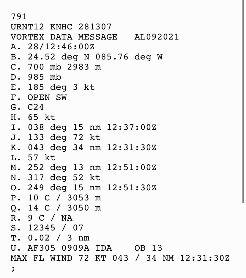
The last pass looks to have actually had a downdraft. Pressure spiked and altitude dropped
-
1
-
-
1 minute ago, Amped said:
Sfmr probably overdone, but still safely a cat 5 now.
Not with SFMR of 145. Tend to need around 150 to get cat 5 with the standard 10% reduction.
-
Just now, etudiant said:
Is there a good explanation for this critical course change or is it projected based on historical precedent?
It’s all modeled based on physics. Big picture there’s high pressure west and NE so it will head north between them
-
1
-
-
12 minutes ago, Sandstorm94 said:
Flagged 148kt SMFR in NE eyewall
Sent from my SM-S115DL using Tapatalk
This wasn’t in the eyewall. It was over the delta (land) which caused it to get flagged
-
1
-
-
Looks like the eye is circular now. Still not closed but now that it’s circular it should happen pretty soon.

-
2
-
-
Still having mist in Wichita Falls. Cloud deck is pretty thick
-
Isolated supercell about to cross into AL.

-
That radar is far enough away for it to not be too useful. All you are seeing is the meso. Based on BMX, the tornado likely never handed off.
-
1 minute ago, David Reimer said:
Tornado just handed off to a new circulation. New significant tornado in progress about a mile east of the old one.
I don’t think it has. It’s the same circulation. It’s just extremely close to the radar.
-
I’m pretty sure it’s still a tornado. Based on radar I think it hasn’t lifted at all.
-
-
Western MS is rapidly clearing on satellite
-
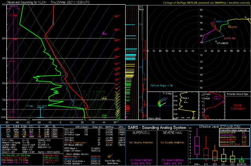
LCH 12z sounding is a classic loaded gun. Insane EML leads me to think today will be a very long day.
-
1
-
 1
1
-
-
1 hour ago, hlcater said:
I'm not entirely sure what you're seeing. EML is present and accounted for on much of guidance at 15z. Using the HRRR for visualization.

I should have clarified more. The EML is not enough (at least on the soundings I’ve grabbed) to provide substantial capping. The EML isn’t quite warm enough at its base
-
FWIW the whole SPC thing isn’t even meant for the general public at all. It’s guidance mainly for mets and to a lesser extent, emergency management (controls staffing levels). It wasn’t designed for general consumption but it’s gone that way over time. The good thing is that lots of TV mets use the 1-5 scale to communicate it.
-
1
-
 2
2
-
-
There’s a lack of an EML which is usually a sign for me of messy storm mode when it comes to Dixie. Don’t expect a D2 high.
-
3
-
-
-
VBV shouldn’t be an issue. Slight VBV above 3km tends to be present on a lot of long track tornado days.
-
2
-
-
8 minutes ago, KC Storm said:
Ugh sorry msn. Hope you get it back soon
I’m staying with friends so luckily I’m warm. The whole situation is frustrating because of how many areas nearby have never lost power.
-
1
-
-
I’m now around 30 hours without power. This has been absurdly mismanaged by ONCOR seeing as their “rolling outages” haven’t been rolling at all.
-
2 hours ago, jojo762 said:
How's the 50 degree apartment treating you, Jason?

It’s a blast... I found a place to stay for the night that has power.
-
3
-
-
I am once again asking for a Southwest trend in the snow maps.
-
2
-
1
-

Category Five Hurricane Lee
in Tropical Headquarters
Posted
I also think the double wind maxima are just banding since they only show up in the SW and S sides. Thats also the side getting rekt by shear so I don’t think there’s a second eyewall that would survive there but not on the east side.