WebBreaker63
-
Posts
284 -
Joined
-
Last visited
Content Type
Profiles
Blogs
Forums
American Weather
Media Demo
Store
Gallery
Everything posted by WebBreaker63
-
56F and a WWA for freezing rain starting at 1100hrs - Ooofa
-
23F - Frozen Fog early this morning Hopefully uneventful ride into work this morning... All Wheel Drivin' to AC Friday night - bring 'er on
-
4F this morning with a feels like -2
-

January 28th/29th Event Obs - From KU to FU?
WebBreaker63 replied to JTA66's topic in Philadelphia Region
Heavier bands forming to the north in Mercer County and looking to head south into Bucks at the moment 19F Snow - 6" est -
January 28th/29th Event Obs - From KU to FU?
WebBreaker63 replied to JTA66's topic in Philadelphia Region
Heaviest snow and wind of the morning Down to 21F IMBY 4" -
January 28th/29th Event Obs - From KU to FU?
WebBreaker63 replied to JTA66's topic in Philadelphia Region
Bands don't seem to be coming west of GSP - I always found it interesting on the weather boarders throughout the years, In NJ it was always west of the GSP (today its east) or the I95 corridor, I 76 etc.,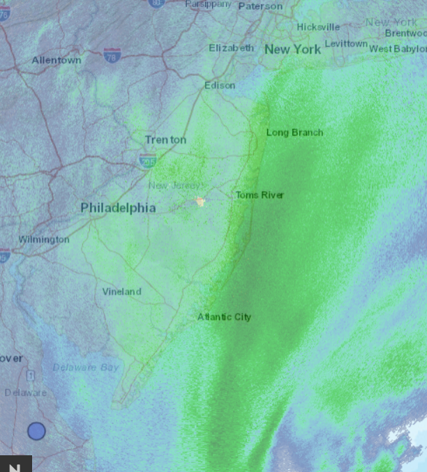
-
January 28th/29th Event Obs - From KU to FU?
WebBreaker63 replied to JTA66's topic in Philadelphia Region
It actually works the best for the heavier stuff, takes all the pressure off the back - but ohhh the arm work out. Down to 22F and snow W NNE 8mph - gusting to 18mph -
January 28th/29th Event Obs - From KU to FU?
WebBreaker63 replied to JTA66's topic in Philadelphia Region
My wife and I actually rescheduled are weekend trip for next week - me I would have been out walking the boards already, the Mrs. Uhhh, not so much... -
January 28th/29th Event Obs - From KU to FU?
WebBreaker63 replied to JTA66's topic in Philadelphia Region
AC Boardwalk Cam - for those who are not actually in AC right now https://www.webcamtaxi.com/en/usa/new-jersey/boardwalk-atlantic-city.html -
January 28th/29th Event Obs - From KU to FU?
WebBreaker63 replied to JTA66's topic in Philadelphia Region
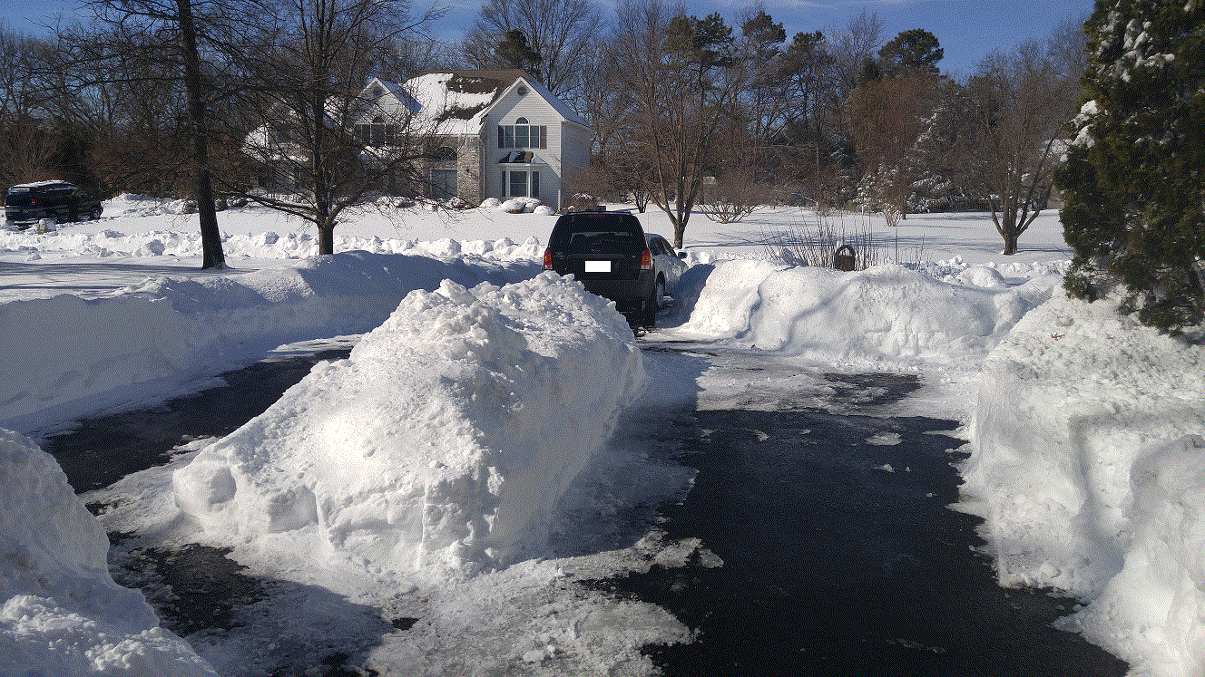
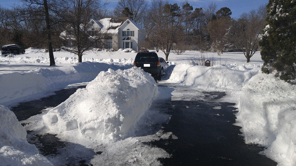
Good Morning - Lower Bucks 23F - Snow (IMBY measure 3.5") W NNE 5-10mph - picking up P 29.54 F Radar looks steady for western movement east for now, what I am looking at is the dry finger in Bel Air MD that could be pointed in our direction, hopefully fills in for a bit. FWIW - I used to live in Toms River, spoke with an ole neighbor, says he has a good foot on the ground and heavy snow. Asked me what time today I was going to be over to help shovel with my Wovel - might be called a Weasel these days (for those who might remember I always swore by the Wovel during the some big storms at the shore from 2010-2015 over the snow blower - also had a 100ft driveway then...) Before you ask Wovel Pic and storm pic from Jan 24 2016 in TR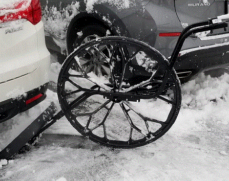
-
January 28th/29th Event Obs - From KU to FU?
WebBreaker63 replied to JTA66's topic in Philadelphia Region
31F Cloudy Melted snow seems to have caused a black ice situation on side untreated streets -
January 28th/29th Event Obs - From KU to FU?
WebBreaker63 replied to JTA66's topic in Philadelphia Region
I think Hazwoper is in Wrightstown PA, I work in Wrightstown NJ in Burlington County - by Fort Dix I get folks that confuse Southampton PA and NJ, I tell them the one in NJ don't have Street Rd to deal with - they don't get it -
January 28th/29th Event Obs - From KU to FU?
WebBreaker63 replied to JTA66's topic in Philadelphia Region
Lunchtime Obs (Lower Bucks) 35F Light's snow P 29.92 S W SE 2mph A bit more than a dusting on grass, side streets wet, were covered this morning. -
January 28th/29th Event Obs - From KU to FU?
WebBreaker63 replied to JTA66's topic in Philadelphia Region
28F Light snow falling Lower Bucks -
January 28th/29th Event Obs - From KU to FU?
WebBreaker63 replied to JTA66's topic in Philadelphia Region
Watching, learning, laughing and appreciating this forum! OBs 27F Feel Like 21F DP 18F P 2995 S Winter Storm Warning for me in Lower Bucks - just over the river in Burlington Cty, Hightstown NJ area where my daughter tells me she is under a Blizzard Warning (Double Checked weather.gov)- didn't think that it came in that far west -
Rain to Snow obs for January 20th winter event
WebBreaker63 replied to ChescoWx's topic in Philadelphia Region
Meh - yeah, if I saw something would have stayed back from work, rain is not a reason. Good Day All -
Rain to Snow obs for January 20th winter event
WebBreaker63 replied to ChescoWx's topic in Philadelphia Region
37F Rain -> Snow line is slowly approaching Lower Bucks FYSA - Weather Underground is calling for 3-5" this morning and NWS still up to 2" -
January 7th First Snow for some N&W folks Discussion
WebBreaker63 replied to ChescoWx's topic in Philadelphia Region
Good Morning 28F/Mod Snow - Southampton Last band on top now, 2.5" IMBY -
32F Cloudy - Upper Southampton Just spoke with co-worker in Manahawkin, just changed to snow (currently 33F), grass and tops of cars, says its coming down, temp continue to fall
-
Special Weather Statement NWS: Sorry not really a read and paste type - just popped up on the laptop Description ...A BAND OF HEAVY SNOW WILL AFFECT MERCER...SOUTHWESTERN MIDDLESEX...MONTGOMERY...SOUTHERN BUCKS...CHESTER...NORTHERN PHILADELPHIA AND NORTHERN DELAWARE COUNTIES... At 540 AM EST, a band of heavy snow was located from about central Chester County northeastward across the lower portions of Montgomery and Bucks counties then into southern Mercer County in New Jersey. This band is lifting northeastward. Snowfall rates of around an inch per hour will be common within this band. Given temperatures in the 20s and the cold ground, road conditions are rapidly deteriorating. In addition, the visibility will be reduced to one quarter of a mile within the heavy snow. Be prepared for snow covered roads. Slow down and allow extra time when traveling. Locations impacted include... Philadelphia, Trenton, West Chester, Bensalem, Ewing, Norristown, Pottstown, Phoenixville, Lansdale, West Norriton, East Norriton, Coatesville, Princeton, Westtown, Bristol, Doylestown, Downingtown, Conshohocken, Hatboro and Ambler.
-
23F Snow Woke up at 430am and there was nothing, back to bed, 540am easily a 1/2"+ on the ground.
-
Upper Southampton 28F Currently Freezing Drizzle Dew Point 12 Winds - Currently E 7mph
-
Upper Southampton 26F Flurries 2-3" Unofficial driveway and top of car total Co-worker mentioned 6" (unverified) in central Burlington Cnty location - at his home in Stafford NJ and still snowing.
-
33F - Upper Southampton Light to Mod snow now - smaller flakes. Just came back from Giant - 4" of snow on the ground, 2" from 0930 to 1030 on top of car while grocery shopping. Roads snow covered, plowed - not icy - All Wheel drive and new tires help
-
Still 32F - just flipped to snow - lightly sticking to the street