WxBlue
-
Posts
2,718 -
Joined
-
Last visited
Content Type
Profiles
Blogs
Forums
American Weather
Media Demo
Store
Gallery
Everything posted by WxBlue
-

March 12/13/14 Blizzard/Winter Storm/WWA etc
WxBlue replied to Bostonseminole's topic in New England
Right in the v of "Dover" label. Figured that might be the case with trees getting in the way. The difference is about 7-8 dbz off according to GR2A so we've been getting 25 dbz stuff all day long instead of 17-18 dbz. -
March 12/13/14 Blizzard/Winter Storm/WWA etc
WxBlue replied to Bostonseminole's topic in New England
So it's safe to say we're in this thin zone between consistent 2-3"/hr band to my west and exhaust stuff to my south and east. Consistent 1-2"/hr rate since mid-morning. -
March 12/13/14 Blizzard/Winter Storm/WWA etc
WxBlue replied to Bostonseminole's topic in New England
Absolutely crushing to north and west of me. Really hopeful it'll drift to east with the storm.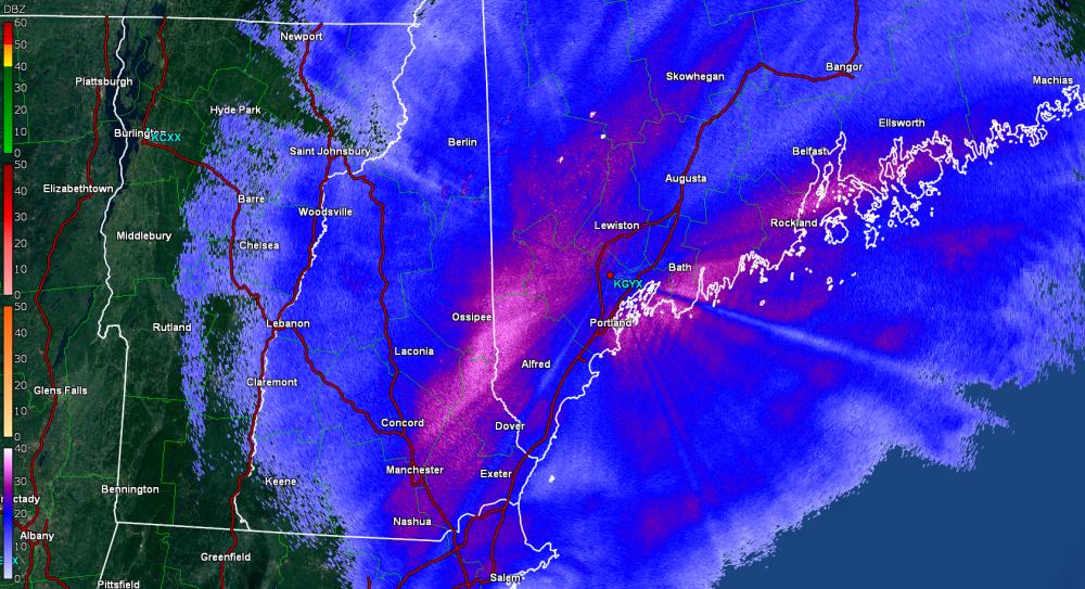
-
March 12/13/14 Blizzard/Winter Storm/WWA etc
WxBlue replied to Bostonseminole's topic in New England
It's drifting over me now. Rate increased to 2"/hr. We're about to pass 10". My goodness. -
March 12/13/14 Blizzard/Winter Storm/WWA etc
WxBlue replied to Bostonseminole's topic in New England
Think someone between ASH and DAW will be local jack close to 20". Definitely not us this time around but we're keeping up. -
March 12/13/14 Blizzard/Winter Storm/WWA etc
WxBlue replied to Bostonseminole's topic in New England
Good stuff swinging back toward us. We're at 8" now.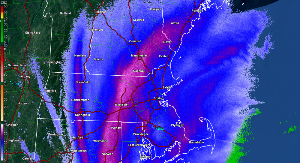
-
March 12/13/14 Blizzard/Winter Storm/WWA etc
WxBlue replied to Bostonseminole's topic in New England
Got a mesoscale discussion from SPC. http://www.spc.noaa.gov/products/md/md0119.html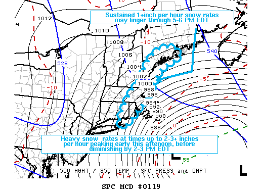
-
March 12/13/14 Blizzard/Winter Storm/WWA etc
WxBlue replied to Bostonseminole's topic in New England
6.7" on the board. 1-1.5"/hr last couple hours. -
March 12/13/14 Blizzard/Winter Storm/WWA etc
WxBlue replied to Bostonseminole's topic in New England
Combined with GYX radar, safe to say we'll get the reforming band too. Losing visibility here. -
March 12/13/14 Blizzard/Winter Storm/WWA etc
WxBlue replied to Bostonseminole's topic in New England
Can we get some latitude with this? I like where we are with that band setting up. -
March 12/13/14 Blizzard/Winter Storm/WWA etc
WxBlue replied to Bostonseminole's topic in New England
As a former outsider, to be fair, 15-30" is mind-blowing stuff outside New England. We simply can't fathom it unless we experience it for ourselves. -
March 12/13/14 Blizzard/Winter Storm/WWA etc
WxBlue replied to Bostonseminole's topic in New England
Getting close to 5" by now. Really pouring with that band now over us. -
March 12/13/14 Blizzard/Winter Storm/WWA etc
WxBlue replied to Bostonseminole's topic in New England
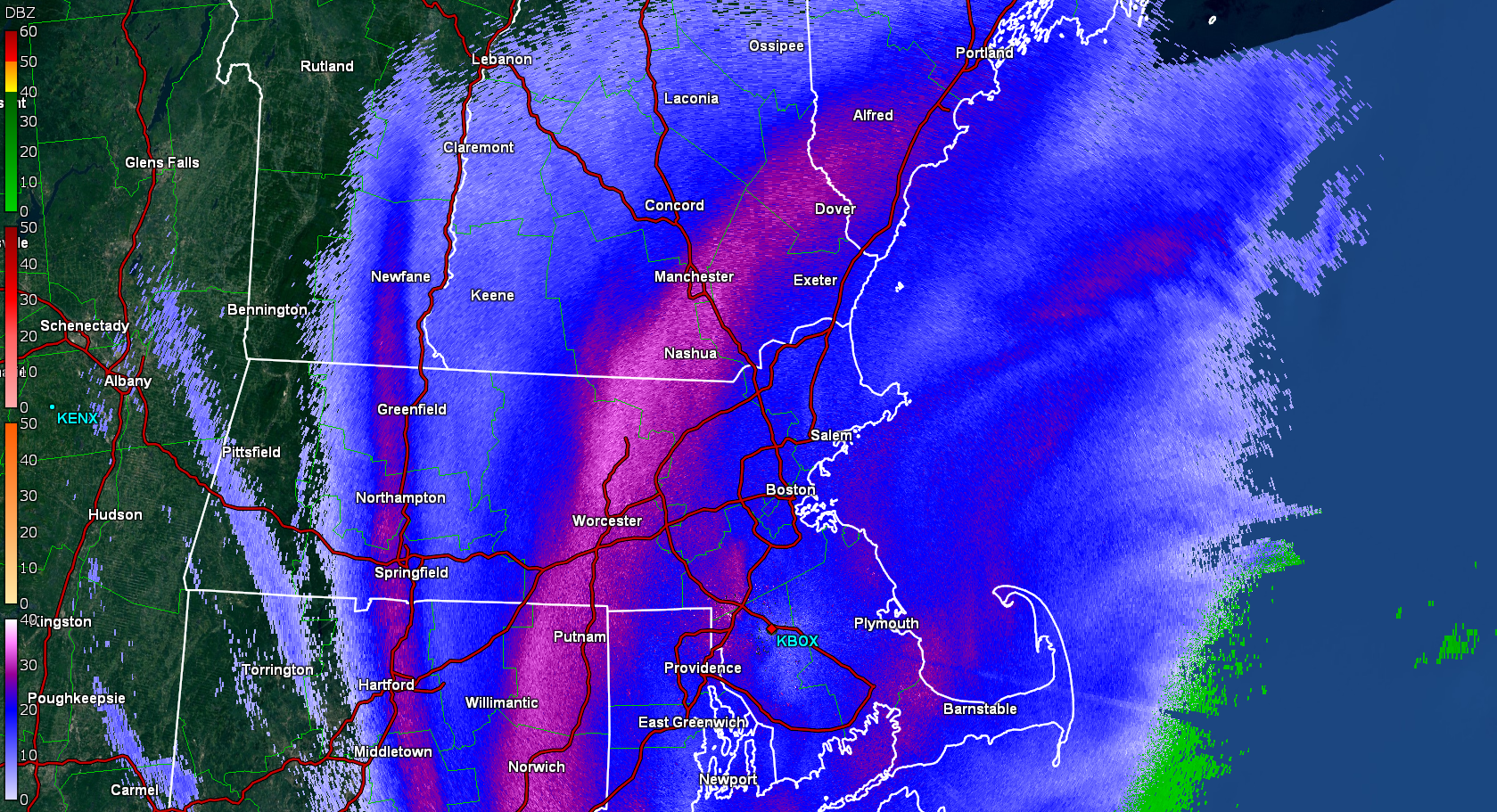
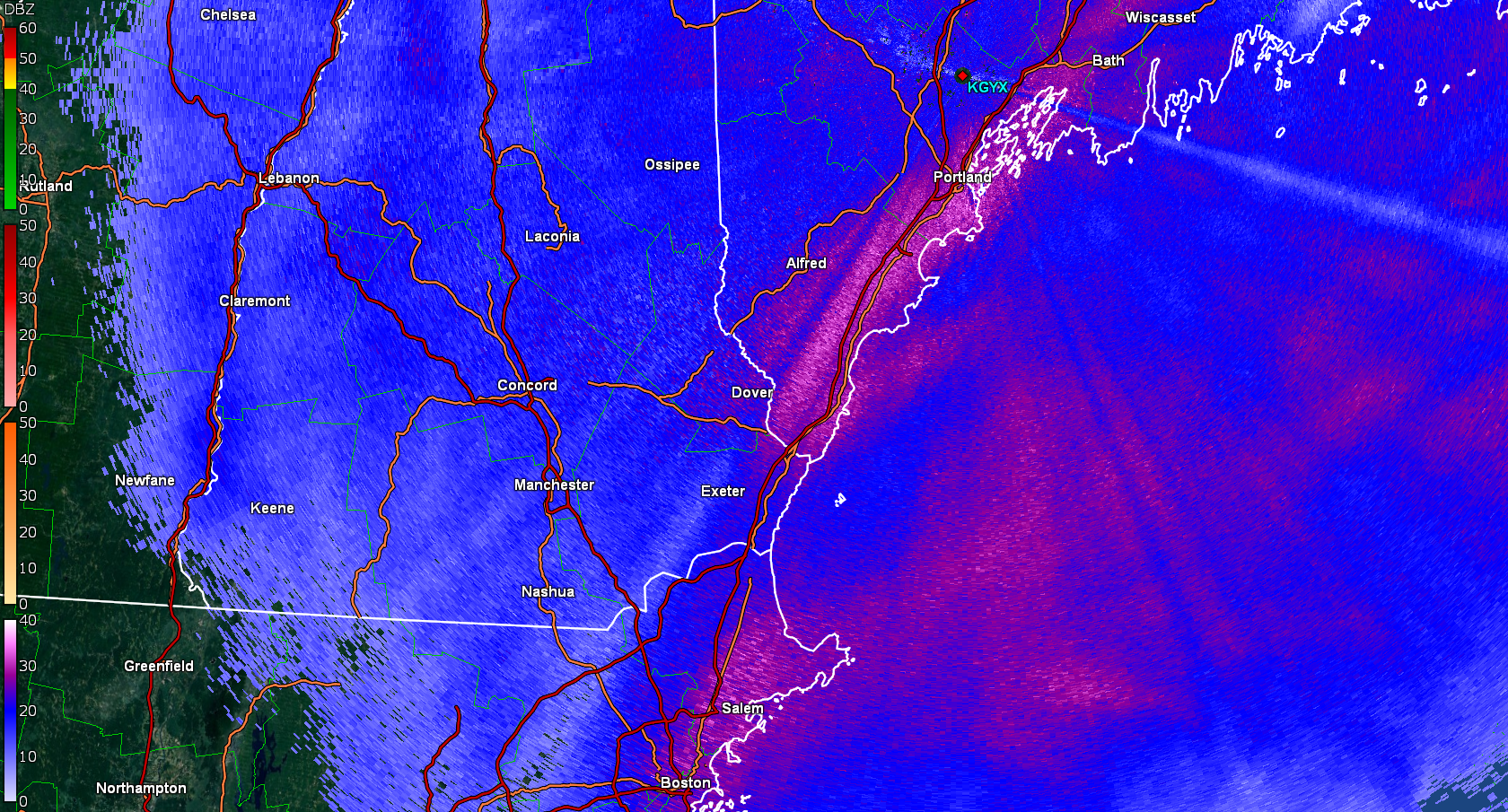
Beam blockage on GYX radar is a bit annoying because it's hard to tell what's going on over my town. Oh well... definitely a band setting up along the Seacoast NH/Maine.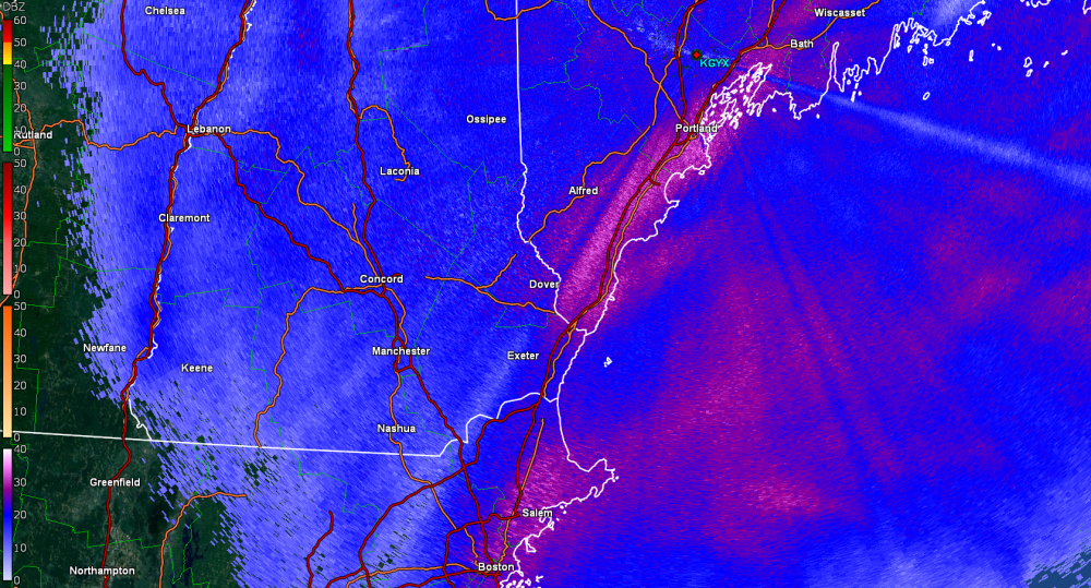
-
March 12/13/14 Blizzard/Winter Storm/WWA etc
WxBlue replied to Bostonseminole's topic in New England
All is good. That's a good way to put it. -
March 12/13/14 Blizzard/Winter Storm/WWA etc
WxBlue replied to Bostonseminole's topic in New England
Just measured 4.2". Not bad but rate will need to improve if we want to meet GYX's 20" call around here. That coastal band is trying to push a little more west and park it over us so we'll see. -
March 12/13/14 Blizzard/Winter Storm/WWA etc
WxBlue replied to Bostonseminole's topic in New England
I mean... you're not wrong. It's useful for nowcasting in several scenarios, but I'm not sure banding nor'easters are one of them. -
March 12/13/14 Blizzard/Winter Storm/WWA etc
WxBlue replied to Bostonseminole's topic in New England
HRRR is a nowcasting model. -
March 12/13/14 Blizzard/Winter Storm/WWA etc
WxBlue replied to Bostonseminole's topic in New England
Yikes... a bit east of us. Don't like being in middle of that. -
March 12/13/14 Blizzard/Winter Storm/WWA etc
WxBlue replied to Bostonseminole's topic in New England
Vertical cross section on Tropical Tidbits FTW. Levi out-did himself once again on this one.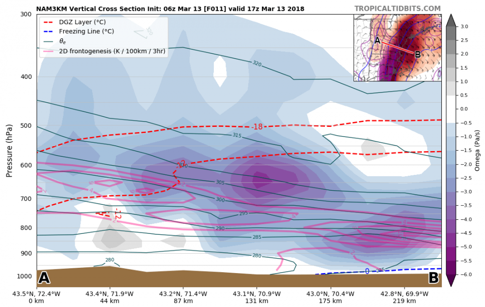
-
March 12/13/14 Blizzard/Winter Storm/WWA etc
WxBlue replied to Bostonseminole's topic in New England
Agree. Our upper range is more like 25" if NAM is correct (now that'd be insane on top of our 6-8" pre-storm depth). -
March 12/13/14 Blizzard/Winter Storm/WWA etc
WxBlue replied to Bostonseminole's topic in New England
GYX actually bumped our forecast to 20". That will be interesting... -
March 12/13/14 Blizzard/Winter Storm/WWA etc
WxBlue replied to Bostonseminole's topic in New England
Just like last week. -
March 12/13/14 Blizzard/Winter Storm/WWA etc
WxBlue replied to Bostonseminole's topic in New England
As far as I'm concerned, this storm is gravy stuff that'll go on my biscuit southern-style. It's much easier to appreciate it even if we fall short of my 14-20" range since we already had this dance last week. 1.8" on my snow board so far. A bit below our pace due to subsidence. -
March 12/13/14 Blizzard/Winter Storm/WWA etc
WxBlue replied to Bostonseminole's topic in New England
Don't steal our band! -
March 12/13/14 Blizzard/Winter Storm/WWA etc
WxBlue replied to Bostonseminole's topic in New England
Been a slow event so far, relatively speaking, but it's about to pick up with that band rotating toward us.