
tramadoc
-
Posts
793 -
Joined
-
Last visited
Content Type
Profiles
Blogs
Forums
American Weather
Media Demo
Store
Gallery
Posts posted by tramadoc
-
-
AKQ has changed my forecast to almost 3” with snow until around 4am.
Sent from my iPad using Tapatalk -
The 3K NAM is verbatim WSW criteria for AKQ CWA.
Sent from my iPad using Tapatalk -
Let’s be honest... how real do we think this is?
Sent from my iPad using Tapatalk -

Imma just leave this right here for everyone to s**t their pants over.
Sent from my iPad using Tapatalk -

As of 3am per the RAP.
Sent from my iPad using Tapatalk -
Found it. https://weather.us/model-charts/rapid-us/north-carolina/snow-depth-in/20180118-0900z.html
Just change parameters. How good is the RAP?
Sent from my iPad using Tapatalk
-
Yes you are. Verbatim 6" per 17z RAP...
12z NAM kinda crushed my hopes, but they're back up after a couple of good runs. I have to stop model watching, it's like a drug lol
Can you post a link to the RAP? I looked on TT, but can’t find it.
Sent from my iPad using Tapatalk -
Very cool. Hopefully we see WSW's.Yes you are. Verbatim 6" per 17z RAP...
12z NAM kinda crushed my hopes, but they're back up after a couple of good runs. I have to stop model watching, it's like a drug lol -
Am I in that? LOL16z HRRRRRR and RAP both show 4"+ for VB. Verbatim they have a 4"+ strip of snow from Ocracoke into Hampton Roads. NWS usually goes with a blend of those two models when forecasting inside 12-18 hours. It has gotta be hard right now for AKQ mets because most everyone here expects 2" at most.
In other news, temperature is down to 31 degrees on the closest PWS. KORF is at 32 at 1pm. Mixing ain't happening. -
-
@SteveVa I think we might get a couple of inches and maybe more if that low creeps closer.
Sent from my iPad using Tapatalk -
Have the MA guys started their meltdown yet?
Sent from my iPad using Tapatalk -
Maybe we get the 3-4" I was hoping for. Fingers crossed.
-
Wear a mask and come back as The Masked Assassin like Dusty Rhodes did back in the day.I wanna come back as backpacker!
-
Thought you might like this from the latest AFD from Wakefield.
Confident in period of moderate snow inland, given well-modeled
narrow band of negative EPV dropping over the SW zones in the
Piedmont (I-85 corridor). There could be a very narrow corridor
of 4-6" of snow in this band. However, expect this would be very
localized and hard to pin- down, so there is no need for a
watch or warning at this time. Slightly less confident into SE
VA. To reiterate...we have issued a Winter Weather Advisory
over Hampton Roads for the late morning and afternoon. However,
we are still a bit concerned with sharpening axis of F-Gen/OPRH
depicted by the 12z (and now 18z) high-res NAM. Issue will be
that we will have a very narrow window within which to receive
moderate snows into Tidewater area, before best axis of moisture
slides offshore. Potential is there for warning criteria snows
(and criteria is 3" for SE VA). However, after collaboration
with neighboring offices and WPC, will hold off with warning for
now. Narrow window of potential snowfall is the primary issue.
Should later model runs continue to depict this potential, an
upgrade to a Winter Storm Warning for all or part of the Hampton
Roads area may be needed.
Sent from my iPad using Tapatalk -
What are the chances totals down this way go up?
Sent from my iPad using Tapatalk -
Pivotal weather has the kuchera ratio maps
Hi Res 18z NAM
Kuchera ratio map for the height of the precip in our area. Healthy 12:1 to 14:1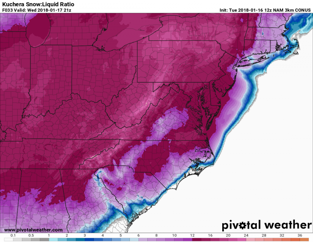
Thanks Steve. Looks as if we are on the upswing with totals. I’d like to see at least 3-4” if possible around here. Hope everyone scores.
Sent from my iPad using Tapatalk-
 1
1
-
-
Rates will overcome?

Heard that song and dance before.
Sent from my iPad using Tapatalk-
 1
1
-
-
Kids in VBCPS have been out for 7 school days for the Jan 4 super-extra-mega-bomb-cyclone. They will probably be out tomorrow and possibly Thursday.
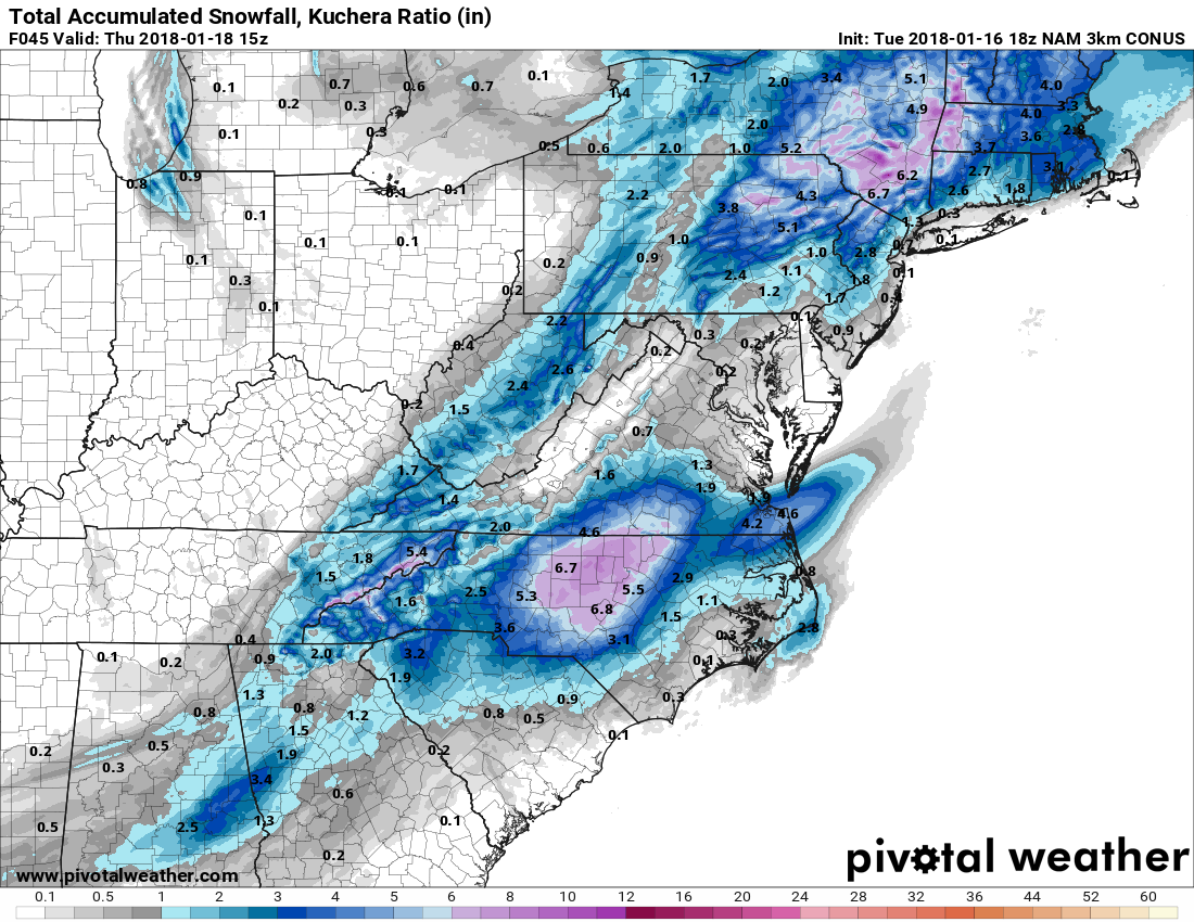
On topic...I don't know what we did to deserve 18z NAM, has about 5" for ORF using Kuchera ratios. RIC might get fringed though.
I really hope that everyone can score better than 2” with this. The NAM has been trending wetter farther east with each successive run. I am hoping and praying that it’s correct and RIC, ORF, ECG all see amounts 3” and higher.
Where did you find the Kuchera graphics? Can you post ECG for me? Thanks in advance.
Sent from my iPad using Tapatalk
-

12K NAM looks really good for you guys up around RIC, all the way to ORF, and down to ECG.
Sent from my iPad using Tapatalk -
-
I can't take the constant snark that DT has.Good tip. I know DT is bullish and everybody, and I mean everybody here at my office follows him. We have had a couple of opportunities but none have truly delivered and I can't complain in a region that can go years without a snow chance when we have 3 before the end of January but the hate for the RIC in other threads is a bit annoying. It's like we get dumped on all the time. Bob C. put a nice PSA out there and did some clean up in the thread but wow, winter is not over and I will bet a dozen Krispy Kremes that Winchester, DC and other points will do far better than RVA when all is said and done. -
In their revised AFD at 1140 or so, they stated that looking at 12Z model runs they might put up a WWA for NE NC and SE VA during next package output due to increase in QPF.AKQ lowered their forecast to 1" for Norfolk/Va Beach. They decided not to issue a WWA either, hopefully the band doesn't dry up and we overperform.33 degrees w/ a visibility of around 1/2 mile. If the fog doesn't clear out in time we could seriously undercut the forecast high of 45.
By the way, we won't hit our forecasted highs for the day.
-
Sure are a lot of new people on the board.

Richmond Metro/Hampton Roads Discussion
in Mid Atlantic
Posted
Light snow and 29.8