Vol4Life
-
Posts
413 -
Joined
-
Last visited
Content Type
Profiles
Blogs
Forums
American Weather
Media Demo
Store
Gallery
Everything posted by Vol4Life
-
Yea…I miffed by the NBM. It’s interesting that it looks like it uses old data/model runs. Please let us know what you find out.
-
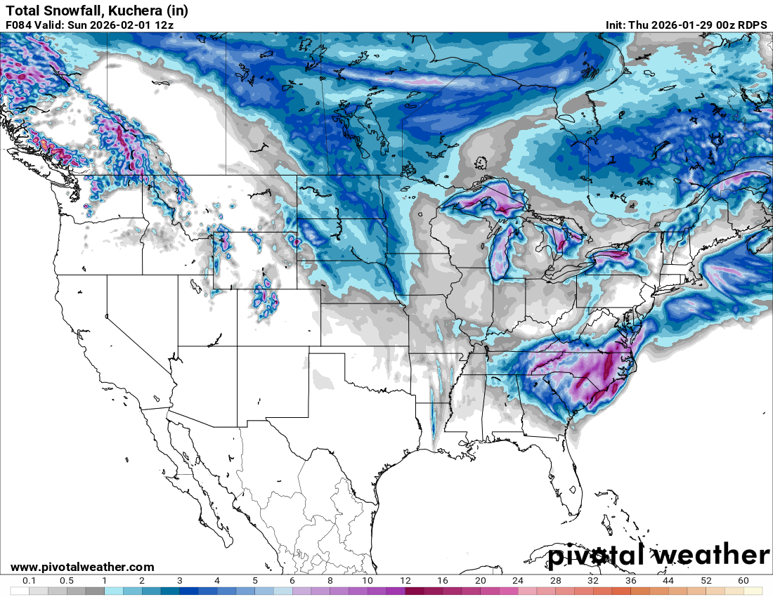
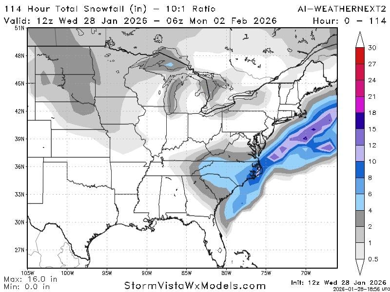
1-2” back to Nashville, 3-4” plateau, 5-6” around Knox, 6-8+ up in NETN

- 782 replies
-
- 4
-

-
- extreme cold
- snow
- (and 1 more)
-
RGEM starts the snow in ETN around 10 pm on Friday and ends around 8 pm on Saturday except for the mountains where it continues for another couple of hours
- 782 replies
-
- 2
-
-
- extreme cold
- snow
- (and 1 more)
-
RGEM at 0z is looking good. It continues to show the best solution for most of the forum.
- 782 replies
-
- 2
-
-
- extreme cold
- snow
- (and 1 more)
-
I would cash out and not complain one time about this winter or the next 2 or 3!
- 782 replies
-
- 2
-

-
-
- extreme cold
- snow
- (and 1 more)
-
Was the difference that the ULL closed off further west and south?
-
Would it be possible to post map? I don’t have access to 18z
- 782 replies
-
- 1
-
-
- extreme cold
- snow
- (and 1 more)
-
The models have been showing a pretty abrupt cutoff. For example, Knox County is being shown on multiple models as a 4+ inch difference from east Knox to west Knox.
-
Besides the RGEM and GEFS (looked decent), I’m not really liking the 18z suite
-
I honestly don’t love that run of NAM. Better than 12Z, but we need it to close off further w/sw
- 782 replies
-
- 2
-
-
- extreme cold
- snow
- (and 1 more)
-
that’s 10:1 ratio. Likely to be closer to 20:1
- 782 replies
-
- 1
-
-
- extreme cold
- snow
- (and 1 more)
-
Yes, it wouldn’t take much 50-100 miles makes a world of difference.
-
Kuchera looks a little more promising. 3.4” at TYS
- 782 replies
-
- 1
-
-
- extreme cold
- snow
- (and 1 more)
-
Something is going on with the Euro. It is still stuck at 75h. Wouldn’t be surprised if there’s some feedback issues.
-
You said earlier that you’d take an inch. This is for greater than 2”. The hope is still alive! lol!
- 782 replies
-
- 2
-
-
- extreme cold
- snow
- (and 1 more)
-
How different is it from 06z? I feel like it hasn’t been firmly in the camp with GFS and CMC. It’s made steps towards those solutions, but is still barely on the outside looking in.
-
Good write up from NWS that came out about 15 min ago. They are starting to buy in. On phone…tried to copy, but I can’t get it to post here.
-
I tend to trust the AIGFS a little more with precip totals….not just because it’s better for my backyard, but in its short time of existence, it appears to be a little more reliable.
- 782 replies
-
- 1
-
-
- extreme cold
- snow
- (and 1 more)
-
It looks like the Low pressure was at or just inside Cape Hatteras at 84 on RGEM
- 782 replies
-
- 1
-
-
- extreme cold
- snow
- (and 1 more)
-
RGEM shows 2+ from Nashville eastward. At 84, TYS has 3.5” and it’s still snowing from the plateau eastward
-
RGEM looks good out to 75
-
Yes, I guess that’s due to snow downsloping issues maybe. Either way, would love for the precip shield to keep growing back to the west.
- 782 replies
-
- 1
-
-
- extreme cold
- snow
- (and 1 more)
-
100%! Just giving him a hard time. For all the time and effort he puts into this board, he deserves a huge snow!
-
GEFS mean at 0z is almost identical to 18z Edit: 0z is a a little improved.
-
CMC at 0z is a nice hit from Nashville East. Improvement from 12z with westward expansion of accumulation