

vpbob21
-
Posts
202 -
Joined
-
Last visited
Content Type
Profiles
Blogs
Forums
American Weather
Media Demo
Store
Gallery
Posts posted by vpbob21
-
-
Picked up almost 7" here. That takes my total for the season above 17". Last year I didn't reach 17" until February 12.
-
36 minutes ago, Gino27 said:

I spoke too soon. <1" for me now...
I would take 2-3" and be happy with it. Unfortunately I suspect that is way overdone.
-
17 minutes ago, Jim Martin said:
0z GFS same as the previous runs earlier today.
Obviously not as good as the NAM but I thought the 0z GFS improved over the 18z. The trough looks like it goes more negative tilt and the heavy snow gets back into the I-77 corridor. Need a few more bumps west but hopefully we can reel this one in.
-
5 minutes ago, CoachLB said:
3K looks even further west.
Wow, didn't see that coming. The NAM runs had been awful up until that one.
-
1 hour ago, McHenrySnow said:
You've had more than most.
I have to laugh at Ohio finally getting one decent storm and all of a sudden it's like we're the snowiest place on earth. And it's not like that storm crushed the whole state - I don't have a snowfall map but I would guess at least half the state got less than 4 inches. I did alright with 7.5" but most of the big totals were in the snow belt where they expect to be buried.
The last 3 or 4 winters have been brutal for snow in this area. CLE's snow the last 2 winters combined is close to what 1 normal winter should bring. In spite of the 10" in the 12/1 storm CLE is barely above normal for the season and will probably be below by Christmas Eve. And it's far from certain that the Christmas Eve system produces in Ohio.
I would love for the entire subforum to have a good winter, but if most of the action passes through Ohio, I won't feel a bit guilty.
-
Right around 7" here. Better than I expected.
-
7 minutes ago, jrips27 said:
Greetings all,
I’m thinking of driving up from the Atlanta area for Sunday-Tuesday and getting a cheap hotel somewhere in West/SW Ohio to see some flakes fall. Working from home for now so that allows me to go anywhere there is WiFi.
Knowing quite literally nothing about Ohio - any tips on good spots that typically do well in these changeover setups? I was looking for somewhere around Dayton since it’s a bit shorter drive but willing to go anywhere. Bellafontaine caught my eye cause it sounds more elevated.
EURO backed off a little bit but still a good thump (especially by Atlanta standards
 )
)
Yeah I think Bellefontaine would be a great place to be in this setup. I think that area was the jackpot zone when Sandy came through here a few years ago.
-
 2
2
-
-
1 hour ago, WHEATCENT said:
yeah the long range models don't do well with LE, I'm in Mentor so we hardly ever get good lake effect here.
This looks like a classic early season borderline temperature storm that's going to be a rainer near the lakeshore. I don't know how close to the lake you are but I can see the lake from my window so I'm in the heart of the screwzone. The good thing for you is that even if this one fails you'll have plenty more chances to get slammed. Can't say that here where we only get synoptic snow. This may well be the big event of the entire winter and we're likely to be shut out.
-
18 minutes ago, fyrfyter said:
Maybe better luck with the lake enhancement on Tuesday?
Maybe but I'm not really optimistic. With temperatures as borderline as what's being modeled any wind passing over the lake is probably going to screw the shoreline. I can see myself looking at bare ground while 5 miles inland gets 6-10". Maybe not as brutal as the 12/1/74 storm where amounts went from 1" to 20" across 5 miles (naturally I was on the 1" end) but still a heartbreaker.
-
2 minutes ago, fyrfyter said:
Euro is weaker and phase is late. Much lighter accumulations for much of Ohio.

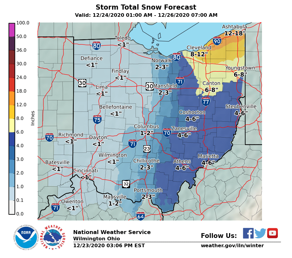
I'll take the under on that 9.5" that map shows for me. My feeling is that areas near the lake will be lucky to see anything measurable.
-
9 minutes ago, Hoosier said:
Somebody stole a bunch of Ohio posters. At least that's my story and I'm stickin to it.

We're all standing at the edge of the cliff waiting for the 12z Euro to tell us it's time to jump ...
-
3 hours ago, nwohweather said:
I’m kind of shocked. Went to Dick’s Sporting Goods and Target today, deader than a usual day. Crazy slow, let alone for a Black FridayThat's certainly not the case around here. I had a couple stores I wanted to go to today, but saw completely full parking lots so I just kept on driving.
-
On 10/2/2020 at 2:09 PM, Hoosier said:
It is actually possible that the next 2 weeks will be more boring than the past couple. Can't we get some tropical remnants or something?
Southern parts of the SF (at least) may have a shot with Delta. 12z models have moved north quite a bit.
-
3 hours ago, Hoosier said:
Large increase in cases in Ohio. Could be a one-off that quickly settles back toward baseline. Will have to monitor trends there in the coming days.
I think a lot of that increase can be attributed to the big spike in cases at the Marion Correctional Institution. Marion County has gone from 91 cases to 983 cases in just the last 5 days. What's concerning to me is that the virus finally seems to be moving into rural areas. My county has gone from 5 cases to 28 cases in just the last week. Dewine is talking about opening up the state by May 1 - IMO it is way to early to even be thinking about it.
-
Line of snow came through and was really lame. Probably 5 minutes or so of 1 mile visibility snow. I was hoping for a quick 1/2 - 1", but not even close. Hope it does better for you guys out east.
-
Got about 2.5" here, 1" from the synoptic snow then that lake band swung through and dropped another 1.5". Probably as well as we could have expected.
-
Great analysis OHweather, as always.
I mentioned in the main thread that I just find it hilarious that Ottawa/Sandusky/Seneca/Erie/Huron/Lorain/Medina counties are the missing link in an otherwise unbroken string of winter headlines that runs from Montana to Maine. I guess I can't really blame them for not wanting to pull the trigger, knowing how bad our snow climo is around here. I do think some of the counties left out of headlines will eventually be added, especially Lorain and Medina (perhaps even warnings there) and probably the inland counties of Huron, Sandusky and Seneca. The lakeshore counties might be a little more borderline with the warm lake temps cutting into accumulations, but at the least it looks like everyone should get on the scoreboard for the season.
-
Just walked outside to get the mail and it's downright brutal out there. Sustained winds probably 30 mph with gusts 40-45 mph. We have been in between bands of heavier snow for the last couple hours but according to radar better snow is about to move in. Hard to measure but probably around 2.5" so far here.
-
1" of snow here in Erie County. Biggest snow of the season so far.
-
Even my area got on the scoreboard this morning with .5". Didn't expect it.
-
19 hours ago, NEOH said:
CLE is currently at 6.58" for July.... currently #6 wettest. Could make a run at #5 if we get more rain tonight/tomorrow.
And then you have TOL at just .30". Amazing the contrast across 100 or so miles.
Not sure exactly how much I've had but looking at my lawn I'd say I'm closer to TOL than CLE.
-
Nothing but a few flakes here. It's amazing how snow goes out of it's way to avoid this area. Congrats to you guys out east.
-
5 hours ago, OHweather said:
It was too warm near the lake. Sat at 33-34. There have been a couple of marginal events where surface temps have been warmer than modeled. An inch in Huron is ouch. Definitely thought there’d be more based on the radar there, and saw a report on Twitter of 5” in Collins (which is much farther inland). If I’ve learned anything from reading posts from you guys on the lake it’s that I’m never going to get a place right near a body of water if I can help it.
It actually started out fairly promising with close to an inch falling quickly after the changeover, but then the precip rate slowed and some rain started to mix in and pretty much stayed that way through the rest of the event. I'm pretty used to these really borderline events not producing in November and early December but it really hurts when it happens near the end of the snow season when the lake should be colder. I guess it shows how much the warm temperatures the last couple weeks raised the water temperatures. I think with a mostly frozen lake we would have done a lot better.
-
2 minutes ago, Trent said:
I thought the west side was finally going to score with this one. Add another 2-3” snowfall to the list.

You did better than I did. Just over an inch out my way. Only a trace left on the ground this morning.
Northern Ohio Obs/Discussion Part 2
in Lakes/Ohio Valley
Posted
Just shy of 7" here. Nice overperformer. Hopefully we can keep the hot hand for the rest of the season.