

vpbob21
-
Posts
202 -
Joined
-
Last visited
Content Type
Profiles
Blogs
Forums
American Weather
Media Demo
Store
Gallery
Posts posted by vpbob21
-
-
13 hours ago, Floydbuster said:
Here in Summit County, it did not seem as bad as nearly all the surrounding areas. I actually did not lose power, surprisingly. Anyone know what the record highest winds are in the Cleveland area? I know they hit 85 mph gust at Burke Lakefront, I wonder what the highest ever recorded was.
I don't know the answer to this, but I have to think the 1/26/78 Superbomb has to be at or near the top of the list. I know Hopkins hit 82 mph and I think there were some 100 mph reports closer to the lakeshore.
-
 1
1
-
-
1 hour ago, LakeEffectOH said:
Yeah we really need to have a wet spring. Locally my area is only in D0 but just 2 counties west of me is D3. Don't want to see that going into summer.
-
1
-
-
3 hours ago, NEOH said:
The snowpack is slowly fading away and should be gone in the next day or two with warm temps and rain. We've had two good years in a row for snowpack retention so no complaints. Still hoping to hit 100" for the season... not too far away at this point.
Yeah our snowpack finally went to 0 yesterday. I was actually surprised at how long it held on with the sun and mild temps.
Starting to get interested in the system this coming weekend. The models other than the Euro are looking pretty promising.
-
Got about half an inch with the clipper this morning. Definitely didn't live up to all the hype. We'll see if the squalls with the arctic front later do any better.
-
5 hours ago, Brian D said:
With lows in the -sd's/lower -10's, this thread can be over, thank God.
")
Funny, I was gonna suggest the thread be extended until at least 1/31. Down here in the lower lakes the cold looks to peak around Fri/Sat.
Forecast is showing multiple days of lows at double digits below zero. That is impressive down here in the banana belt.
Also a ton of daily records are in play for CLE's CWA. Most records for 1/30 and 1/31 are pretty low hanging fruit (example CLE -4 on 1/30, -5 on 1/31) so some of these could be clobbered by 10 degrees or more.
-
 1
1
-
-
Very impressive snow squall just passed through with vis down to 1/16 mile briefly. Picked up a quick inch of snow. Looks like it'll hit Cleveland in time to really gum up the afternoon rush.
-
Snow has begun here, a bit earlier than I expected. Hope that's a good sign.
-
1
-
-
Got a quick half inch with the squall that came through. Visibility dropped to a quarter mile. Roads are slick.
-
Got a little over 3" here but really difficult to measure with the blowing and drifting.
-
2
-
-
Got about 1.2" here. Most of the models had us getting a DAB, so a nice surprise.
-
Picked up another .1" from this morning's clipper. Visibility was below 1/2 mile briefly.
Over 8" on the season. We have surpassed the entire 2023-24 winter!
-
 1
1
-
-
Got about .9" here. Seasonal snow just under 8".
-
3" here. Hopefully it sticks around longer than what fell Saturday night.
-
2
-
-
Probably a mistake to jinx this one but this is looking like an overperformer for here. Already closing in on 2". That band that went through Erie and Huron counties is delivering the goods. Hopefully it holds together for you guys out east. Nice to finally be on the scoreboard for the season.
-
Once again most of the rain skipped over this area. That line formed about 10 miles south of here. We ended up with less than a quarter inch.
-
This "wet" stretch of weather has been a dud locally. We've had a little over a tenth of an inch (total since Sunday). Looks like south and east of I-71 has been the jackpot zone. Still some chances today but after that it looks like it could be a while before it rains again.
-
1 hour ago, TheClimateChanger said:
Hot one today in the Eastern Lakes. The high reached 93 degrees at Erie, 1 degree shy of the record set in 2005 & 1936. Cleveland officially topped off at 92 degrees, 2 shy of the record set in 1936. However, it reached 95 degrees at Burke Lakefront Airport. May have been a record if the official station was downtown as in 1936. A stout southerly, downsloping flow brought some of the warmest temperatures to the lakefront. Certainly, not cooler by the lake today!
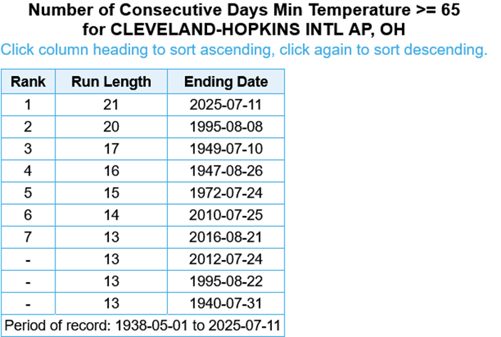
Speaking of Cleveland, yesterday was the 21st straight day with a low temp at or above 65, setting a new record. Will be interesting to see how long they can stretch this as there are no lows below 65 in the forecast for the next 7 days.
-
1
-
-
The National Weather Service in Cleveland has issued a * Severe Thunderstorm Warning for... Cuyahoga County in northeastern Ohio... Northeastern Lorain County in north central Ohio... * Until 945 PM EDT. * At 858 PM EDT, severe thunderstorms were located along a line extending from near Avon Lake to near Grafton, moving northeast at 60 mph. THESE ARE DESTRUCTIVE STORMS FOR NORTHEAST LORAIN AND NORTHERN CUYAHOGA. HAZARD...80 mph wind gusts. SOURCE...Radar indicated. IMPACT...Flying debris will be dangerous to those caught without shelter. Mobile homes will be heavily damaged. Expect considerable damage to roofs, windows, and vehicles. Extensive tree damage and power outages are likely. * Locations impacted include... Cleveland, Lorain, Elyria, Parma, Lakewood, Euclid, Cleveland Heights, Strongsville, Westlake, North Royalton, North Ridgeville, Avon Lake, Warrensville Heights, Grafton, Highland Hills, North Olmsted, Garfield Heights, Shaker Heights, Maple Heights, and South Euclid. -
81 mph gust recently recorded at Lorain County airport
-
I would say we saw 50-55 mph winds as it came through. Tornado warning just to my SE.
-
-
I'll give this winter a C for my area. Not a great winter for snow (around 20") but a lot better than the pathetic 8" total from last winter. One good thing was that what snow came down stayed on the ground for a while, unlike the past few.
If I were grading based on the winters I grew up with in the 70's, this winter would probably get an F. I've had to adjust my grading scale over the years, otherwise just about every winter would get an F.
-
Got about 1.6" here, a little more than I was expecting.
-
Got about 3.5" this morning. Looks very wintry out there!
Northern Ohio Obs/Discussion Part 2
in Lakes/Ohio Valley
Posted
We certainly heard (and felt it) here. From what I'm hearing it wasn't as loud here as places further east, but it was enough to make me look up and say "What was that?"