

DaveNay
-
Posts
668 -
Joined
-
Last visited
Content Type
Profiles
Blogs
Forums
American Weather
Media Demo
Store
Gallery
Posts posted by DaveNay
-
-
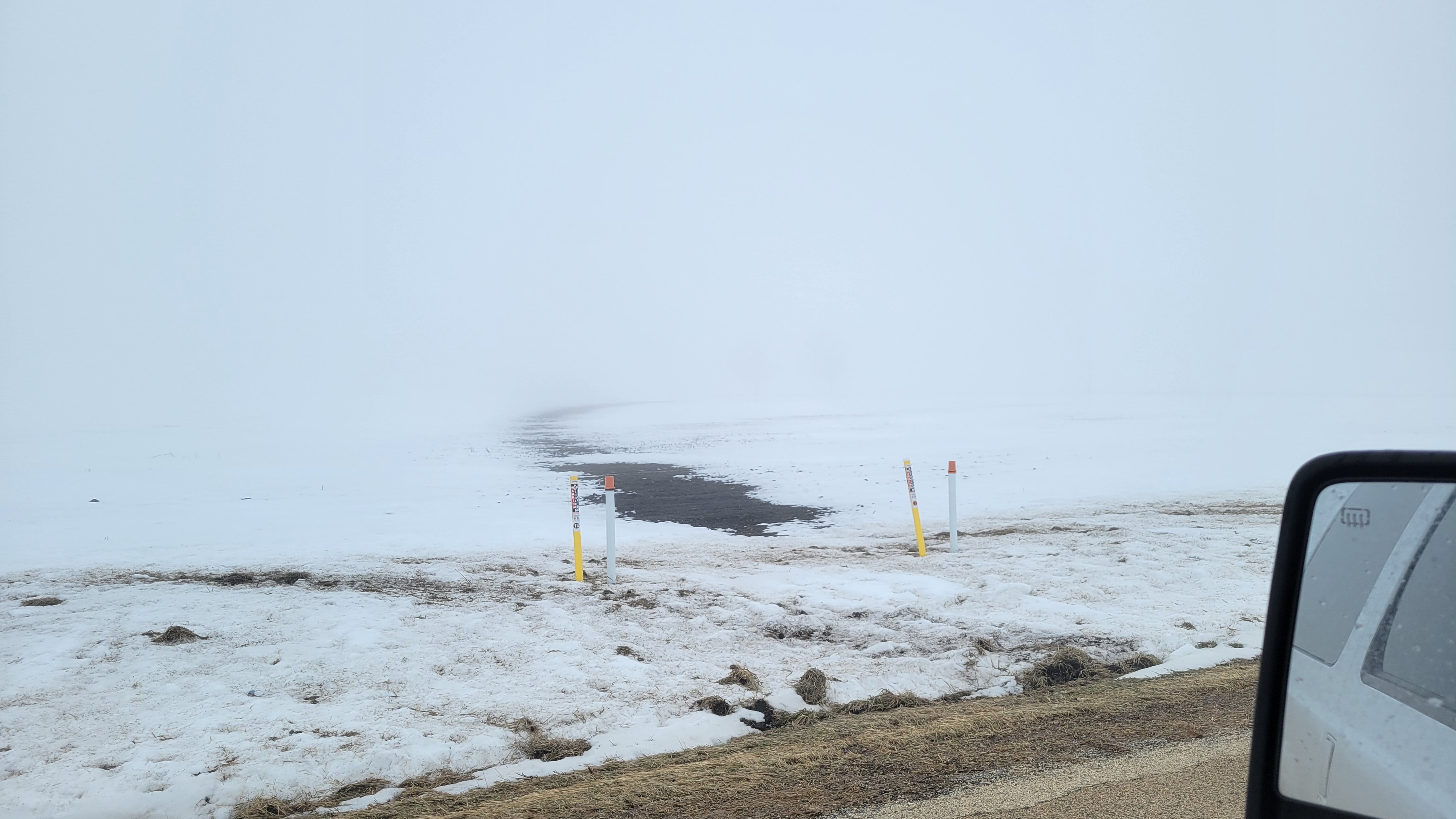
Can anyone spot where the crude oil pipeline is? (sorry, phone had a hard time focusing due to a slight lack of contrast in the atmosphere today)

-
 1
1
-
-
13 minutes ago, A-L-E-K said:
Maybe all the mosquitos will hatch early and then we get another cold snap to kill the bastards.
-
3
-
-
Just now, King James said:
Man imagine if we were just a little over 30 days away from a Morch? Let’s go!
Nine days away from Firebruary.
-
 1
1
-
-
4 minutes ago, RCNYILWX said:
Throw in the SWE and the temperature of the snowpack going into a thaw. At mid day today, our snowpack had unusually high SWE (1.6" on 6-7" SD at LOT) and in general the temperature across the heart of it was quite cold due to extended cold stretch. Those factors initially make it more resilient, with a warmer snowpack going in more prone to "ripening" faster.
There's going to be steady melt but it appears that temps and dew points up in the metro and points west should stay low enough to prevent a nuking of the snowpack over the next several days. That is unless dew points trend higher absent insolation, as it does appear we should stay cloudy through the period.
Sent from my SM-G998U using Tapatalk
I was just outside walking the dog, and quite a bit of my snow has gone from the powder you would expect from the recent cold to packable and able to throw snowballs for the dog.
-
I had to clear the drifts from my driveway yesterday.
Sent from my SM-G991U using Tapatalk
-
4
-
-
22 minutes ago, cyclone77 said:
80.5hrs, you added a day lol. Didn't go below zero till Sat eve the 13th. Very impressive nonetheless!
Correct, thanks. I hate constantly converting between F and C.
-
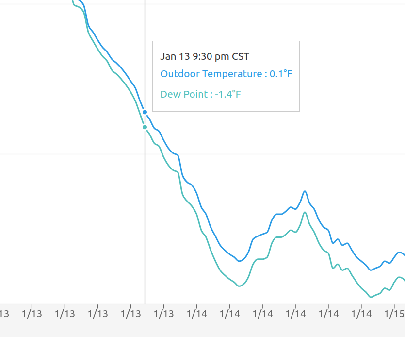
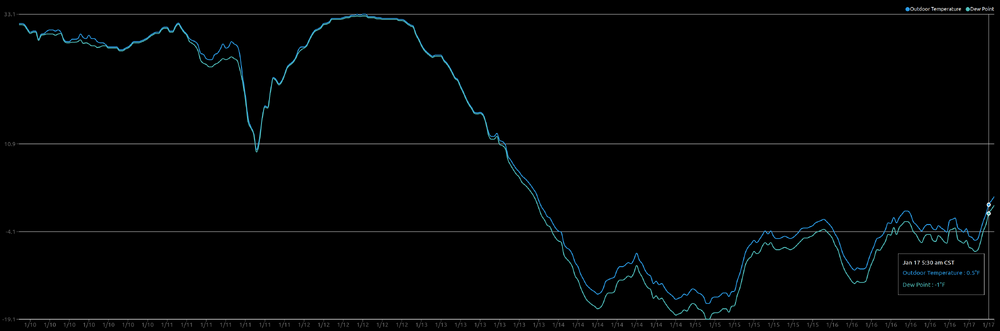
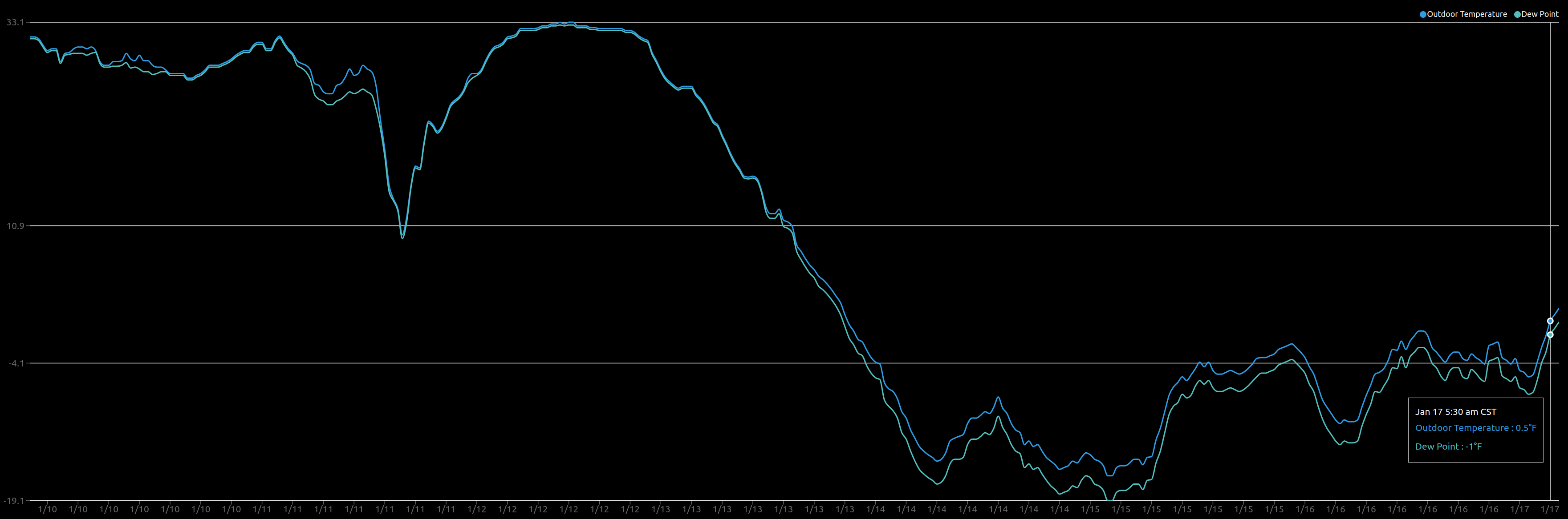
104.5 hours at or below zero at my station.
9:30pm on 2023-01-12 to 5:30am on 2023-01-17
-
A short video from my dash cam this afternoon as I drive around checking out the snowpack (I drive past @SchaumburgStormer old house @11:25).
-
3
-
-
16 minutes ago, frostfern said:
I don’t think interior BC gets 80 degree dewpoints though. I have experienced some PNW heatwaves, and they can be very hot and also humid enough to be uncomfortable, but you never get that steamy tropical feel. It also seems like the most extreme temperatures happen in localized downslope areas. I noticed Olympia Washington hit 110 while Seattle only got to 101. It has something to do with the terrain. There are plenty of extreme places on earth, especially when you consider micro-climates, but the combo of tropical summers and brutal cold winters seems kinda unique to the Midwest US IMO.
Four of the top five are commonly referred to as "inhospitable". The fifth one is the great plains.
https://www.unmissabletrips.com/guides/12-places-on-earth-with-the-most-extreme-weather-conditions
-
53 minutes ago, frostfern said:
Its crazy to me that the same place that has triple digit hear and 80 degree dewpoints in July and August is this cold in the winter.
My coworkers in Germany and UK are simply unable to comprehend the extremes of weather we get in the US.
-
19 minutes ago, Stevo6899 said:
So its gonna be dry all week while we have legit cold air in place, then it warms up, gets active and get rained on.
I'll take 35 and rain over this cold.
-
 1
1
-
-
Rural DeKalb county is basically shut down today. Road crews can't keep up with the drifting. The cold is brutal.
-
6 minutes ago, bowtie` said:
Even this far south, KIND currently at -4F. Brrrrrrrrrrrrrrrrrrrrrrrrrrrrrrr. wind chill of -28, nice,not!
-14.6F here at my station. I hate this shit.
-
1
-
-
Is it just me, or does the intensity and duration of the cold seems to be easing back a bit in the models?
-
2
-
-
Ok, y'all have had your damn snow storms. Is it spring yet?
Sent from my SM-G991U using Tapatalk-
 1
1
-
-
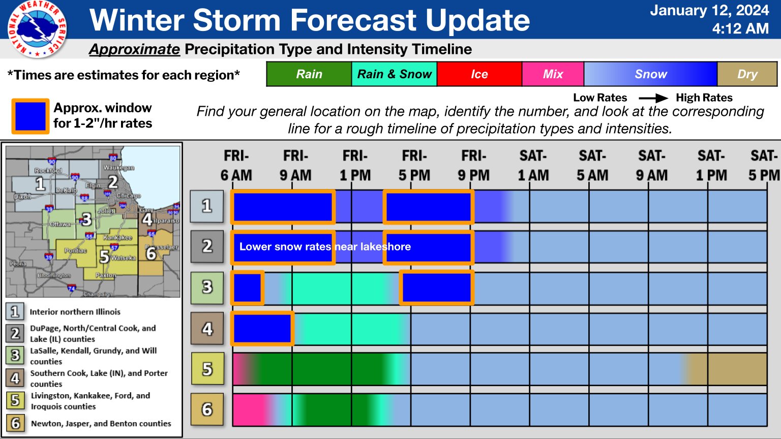
57 minutes ago, Sciascia said:
Officially in dry slot. A shame seeing as NWS Chicago’s belief was that this was a prime time for 1in/hr in the Rockford area until 11am or so.
Hope it fills in in relatively short order.
@RCNYILWX Please ask the powers that be don't change the area numbers from slide to slide. I immediately went to area "4" when I looked, but today I am area "1".
-
2 minutes ago, Chicago Storm said:
6z guidance generally came in weaker/east for the most part, and slower developing.
Weaker/drier/east is a trend you need not want to see in the Chicago metro/NE Illinois. Shall see if it was a one run blip, or if it actually turns into a trend.
.Works for me!
-
2 minutes ago, SchaumburgStormer said:
Hoping for 6” at this point. Higher end totals appear off the table. Heavy bands are pretty transient
Those "heavy bands" in south DKB county you mentioned earlier aren't really putting much down on the ground either.
That rain line is also moving closer every minute...IDK if it will ever reach me though.
-
1 minute ago, Chinook said:
this was earlier today, with over 60mph winds creating severe blizzard conditions in some areas of Kansas
They can keep that shit.
-
2
-
 1
1
-
-
4 minutes ago, CheeselandSkies said:
Is that a 2-stage (has a blower inside the chute in addition to the auger)?
Yes.
-
I think I paid ~$1700, 20 years ago.Wish I had one of those for my tractor. They are soooo expensive.
Sent from my SM-G991U using Tapatalk
-
I'm as ready as I'll ever be.

Sent from my SM-G991U using Tapatalk
-
3
-
1
-
-
3 minutes ago, michsnowfreak said:
I notice people who live in the country tend to just drive over a few inches of snow but in the suburbs people will shovel. My last shovelable 3"+ snowfall was 5.3" on March 10th.
Can confirm. Live in country and I haven't snow blowed the driveway in the last two winters. Porches and sidewalks have been shoveled, yes.
-
3
-
-
I'm not laughing...yet.
-
1
-
1
-

February 27-28 Severe Threat
in Lakes/Ohio Valley
Posted
Just spent 40 minutes in the basement...