WeatherFox
-
Posts
1,523 -
Joined
-
Last visited
Content Type
Profiles
Blogs
Forums
American Weather
Media Demo
Store
Gallery
Everything posted by WeatherFox
-
Unofficially, 1 inch at Central Park.

-
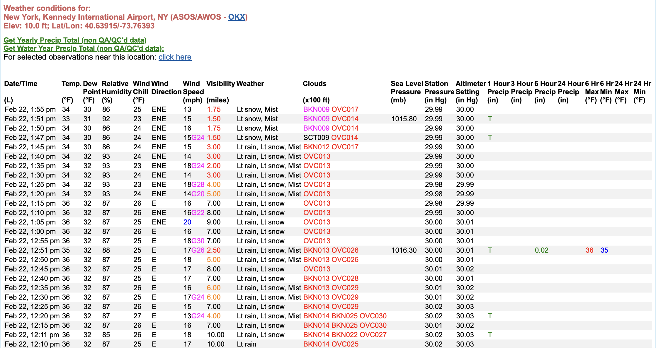
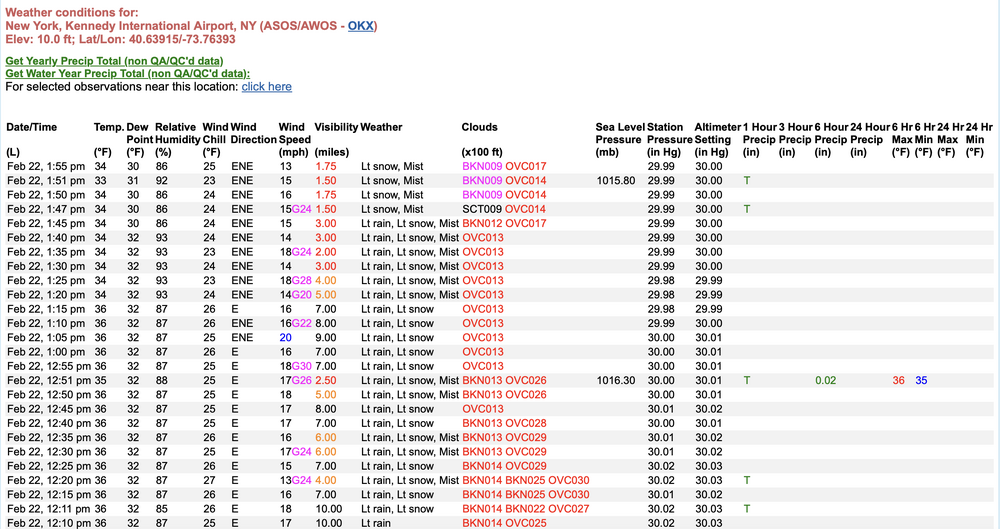
The light rain, light snow flipped at 1:47 PM this afternoon to all light snow at JFK International Airport
-
Congratulations!
-
FOR THE RECORD: Dr. Frank Field served as a meteorologist during his military service. He was a first lieutenant and meteorologist with the 8th Air Force in World War II’s European Theater. This military role trained him in weather forecasting and earned him recognition as a meteorologist by the American Meteorological Society, despite lacking a formal meteorology degree later. After the war, Field briefly pursued optometry—earning his doctorate there—before returning to weather work, starting on New York TV in 1958. His military experience directly paved the way for his five-decade TV career at stations like WNBC and WCBS.
-
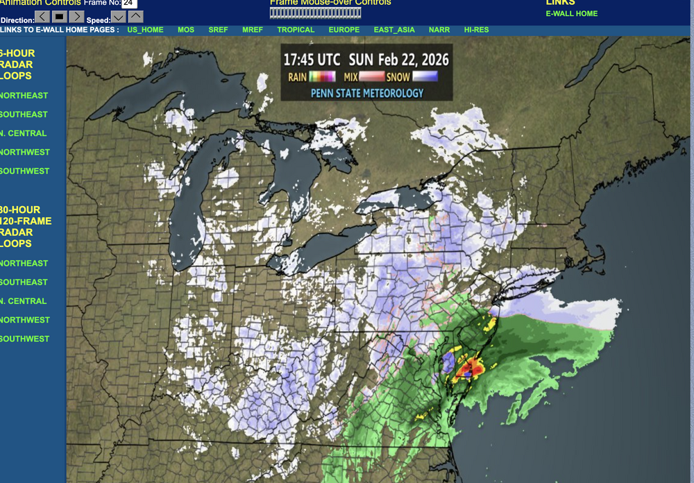
Radar filling in at NYC https://www.meteo.psu.edu/ewall/WXTYPE/loop25ne.html
-
-
Light snow reported at NYC Central Park since 8 am this morning. https://www.weather.gov/wrh/timeseries?site=knyc
-
Been snowing lightly at NY La Guardia International Airport since 8am this morning. https://www.weather.gov/wrh/timeseries?site=klga
-
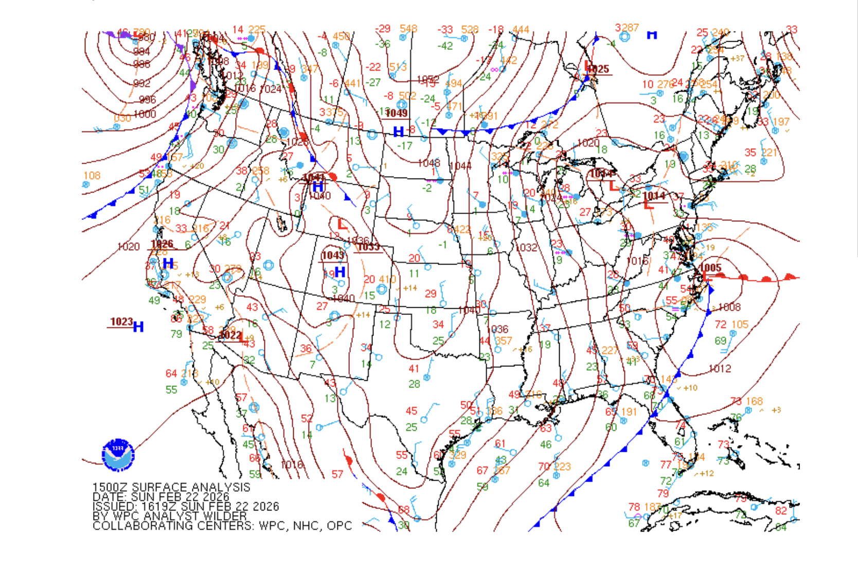
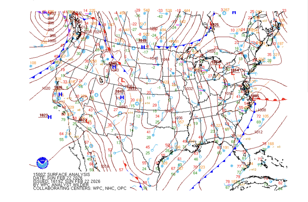
Surface map
-
RADAR https://radar.weather.gov/region/northeast/standard Interactive NYC Point Forecast: https://forecast.weather.gov/MapClick.php?lat=40.7142&lon=-74.0059 NWS Central Park, NYC observations https://www.weather.gov/wrh/timeseries?site=knyc NWS La Guardia Airport New York, La Guardia Airport NWS JFK, NYC International Airport https://www.weather.gov/wrh/timeseries?site=KJFK Regional Roundup NYCRWROKX Live view of NYC https://www.earthcam.com/usa/newyork/timessquare/
-
Bulk from 7pm tonight to 7am tomorrow
-
“A potentially historic winter storm will impact the Tri-State area today into Monday. This is a dangerous situation with blizzard conditions.”
-
Dry slot, boundary layer warms to mixed precip, storm track much further east of benchmark.
-
Snowfall rates can jackpot with thunder snow. Though I have seen it go either way. Either heavy snow, or a change to sleet!
-
Yes, March 4-6, 2001
-
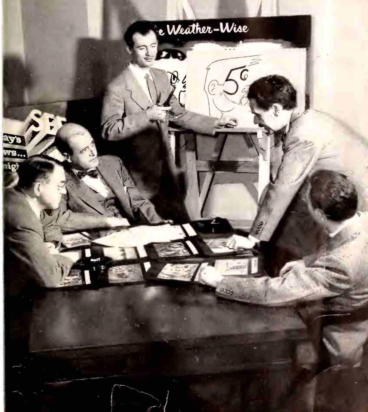
Tex Antoine was a beloved New York City TV weatherman from the 1950s to 1970s, famous for drawing weather maps live with his cartoon sidekick Uncle Wethbee.[wikipedia]
-

-
Forecasts from TWC and models predicted a massive “Godzilla” or “Roidzilla” event, with 15-24 inches of snow possible from Washington, D.C., to southern New England, leading to school closures and panic buying. The system was expected as a multi-day Miller B setup along I-95, compared to historic storms like January 1996 and the 1888 Blizzard. The Bust Instead, the storm underperformed dramatically: only about 1 inch on March 5 in many areas south of NYC, with 3-7 inches elsewhere, and heavier snow (up to Godzilla levels) shifting north/east of forecasts, like eastern Long Island.
-
In the old days we had chief meteorologist Gordon Barnes and meteorologist Alan Kasper.
-
NYC mayor said they are looking for snow shovelers. I used to make a killing when I was young doing that in the neighborhood :)
-
Hmm, just heard AccuWeather on 1010 WINS calling for 12 inches
-
Sunday Snow likely, mainly after 1pm. Cloudy, with a steady temperature around 35. East wind 13 to 16 mph. Chance of precipitation is 70%. New snow accumulation of 1 to 2 inches possible. Sunday Night Snow likely. Cloudy, with a low around 31. Chance of precipitation is 70%. New snow accumulation of 2 to 4 inches possible.
-
The trend is “our” friend. The NWS is bumping accumulations in their forecast. I’m excited even though I am far south!
-
Can u post the map
-
I agree with you. A couple of inches possible around NYC..