WeatherFox
-
Posts
1,523 -
Joined
-
Last visited
Content Type
Profiles
Blogs
Forums
American Weather
Media Demo
Store
Gallery
Everything posted by WeatherFox
-
Northeast
-
-
Regional Weather Roundup National Weather Service New York NY 100 AM EST MON FEB 23 2026 Note: "FAIR" indicates few or no clouds below 12,000 feet with no significant weather and/or obstructions to visibility. NYZ071-072-176-178-NJZ106-104-230700- New York City Metro Area CITY SKY/WX TMP DP RH WIND PRES REMARKS Central Park SNOW 30 29 96 N15G28 29.61F VSB 1/2 WCI 19 World Trd Ctr NOT AVBL Bronx Lehman C N/A 32 32 100 N17G29 N/A WCI 21 LaGuardia Arpt SNOW 31 29 92 N30G43 29.57F VSB 1/2 WCI 16 Queens College N/A 32 30 93 N21G39 N/A WCI 20 Kennedy Intl SNOW 31 30 96 N31G44 29.55F VSB 1/2 WCI 16 Breezy Point N/A N/A N/A N/A N25G37 N/A Brooklyn Coll N/A 32 32 100 N23G36 N/A WCI 19 Staten Island N/A 32 32 100 N13G25 N/A WCI 22 Newark/Liberty SNOW 31 29 92 N31G46 29.60F VSB 1/4 WCI 16 Teterboro HVY SNOW 30 28 92 N20G33 29.60F VSB 1/4 WCI 17 $$ NYZ177-179-078>081-230700- Long Island New York CITY SKY/WX TMP DP RH WIND PRES REMARKS Jones Beach N/A N/A N/A N/A N36G45 N/A Wantagh N/A 32 32 100 N20G37 N/A WCI 20 Hempstead NOT AVBL Matinecock Pt N/A 32 N/A N/A N36G41 N/A WCI 16 Farmingdale SNOW 30 29 96 N31G44 29.51F VSB 1/2 WCI 15 MacArthur/ISP SNOW 31 29 92 NE26G41 29.51F VSB 1/2 WCI 17 Stony Brook N/A 32 32 100 NE9 N/A WCI 24 Shirley FOG 31 30 96 N16G40 29.53F VSB 1/2 WCI 20 Mt Sinai Harb N/A N/A N/A N/A N23G33 N/A Westhampton SNOW 31 30 96 NE26G47 29.51F VSB 1/2 WCI 17 East Hampton LGT SNOW 31 29 92 NE17G29 29.53F VSB 3/4 WCI 20 Southold N/A 32 32 100 NE23G36 N/A WCI 19 Montauk N/A 32 31 96 NE17G36 29.55F WCI 21 $$ NYZ052-065-067-230700- Hudson Valley CITY SKY/WX TMP DP RH WIND PRES REMARKS White Plains SNOW 30 26 85 N22G39 29.58F VSB 1/2 WCI 17 Larchmont Harb N/A 32 N/A N/A N28G36 N/A WCI 18 Croton On Huds N/A N/A N/A N/A N12 N/A Somers N/A 30 28 93 N12G28 N/A WCI 21 Brewster N/A 30 28 93 N14G25 N/A WCI 20 Newburgh SNOW 28 28 100 NE16G24 29.71F VSB 1/2 WCI 17 Montgomery FOG 30 26 85 N15G25 29.71F VSB 3/4 WCI 19 Otisville N/A 28 28 100 NE6 N/A WCI 22 Warwick N/A 30 28 93 N13 N/A WCI 20 Suffern N/A 30 28 93 N16G29 N/A WCI 19 Poughkeepsie LGT SNOW 29 28 96 N13G23 29.73F VSB 3/4 WCI 19 Albany FLURRIES 29 25 85 N8 29.86F WCI 21 $$ NJZ001-105-106-008-010-013-015-019>022-104-230700- New Jersey CITY SKY/WX TMP DP RH WIND PRES REMARKS Newark/Liberty SNOW 31 29 92 N31G46 29.60F VSB 1/4 WCI 16 Teterboro HVY SNOW 30 28 92 N20G33 29.60F VSB 1/4 WCI 17 Caldwell LGT SNOW 30 28 92 NE9G18 29.65F VSB 3/4 WCI 22 Somerville SNOW 30 28 92 N13G25 29.62F VSB 1/2 WCI 20 Linden LGT SNOW 31 28 90 NE18G26 29.61F VSB 1 WCI 19 Perth Amboy N/A N/A N/A N/A N24G32 N/A Sussex LGT SNOW 30 25 81 N13G24 29.69F VSB 1 WCI 20 Andover N/A 29 26 89 N8G22 29.67F WCI 21 Trenton FOG 29 27 92 N20G31 29.60F VSB 3/4 WCI 16 Millville LGT SNOW 30 30 100 N24G35 29.54F VSB 3/4 WCI 16 Atlantic City FOG 31 29 92 N29G44 29.45F VSB 1/2 WCI 16 Wrightstown NOT AVBL Toms River SNOW 30 29 96 N20G30 29.51F VSB 1/2 WCI 17 Belmar SNOW 30 52 100 N28G36 29.51F VSB 1/2 WCI 15 $$ PAZ047>061-062-071-230700- Eastern Pennsylvania CITY SKY/WX TMP DP RH WIND PRES REMARKS Philadelphia HVY SNOW 32 30 92 N28G36 29.63F VSB 1/4 WCI 18 Allentown LGT SNOW 30 29 96 N17G25 29.71 FOG WCI 18 Scranton CLOUDY 28 26 92 NE8 29.73F WCI 20 $$ CTZ002-004>006-009-010-012-RIZ004-006-007-MAZ004-011-015-230700- Southern New England In CT CITY SKY/WX TMP DP RH WIND PRES REMARKS Bradley Intl LGT SNOW 29 28 96 N21G30 29.73F VSB 1 WCI 16 Hartford CLOUDY 30 29 96 N20G31 29.68F FOG WCI 17 Danbury LGT SNOW 31 25 78 N17G32 N/A WCI 19 Wtrbury/Oxford LGT SNOW 28 27 96 N24G40 29.61F FOG WCI 14 Norwalk Harbor N/A N/A N/A N/A N26G32 N/A Bridgeport SNOW 31 29 92 N25G39 29.60F VSB 1/2 WCI 17 Meriden LGT SNOW 30 29 96 N15G32 29.65F FOG WCI 19 New Haven SNOW 31 28 89 N22G33 29.60F VSB 1/2 WCI 18 Chester LGT SNOW 30 32 100 N16G31 29.60F VSB 3/4 WCI 19 Groton LGT SNOW 31 29 92 NE23G45 29.59F VSB 3/4 WCI 18 Willimantic LGT SNOW 30 27 88 NE16G32 29.68F FOG WCI 19 In RI CITY SKY/WX TMP DP RH WIND PRES REMARKS Providence SNOW 31 30 96 NE25G37 29.69F VSB 1/2 WCI 17 Block Island MIX PCPN 31 30 96 NE29G41 29.54F VSB 1/2 WCI 16 Westerly SNOW 31 30 96 NE15G33 29.60F VSB 1/2 WCI 20 In MA CITY SKY/WX TMP DP RH WIND PRES REMARKS Boston LGT SNOW 33 27 78 NE30G40 29.80F WCI 19 Worcester SNOW 26 25 96 NE16G39 29.71F VSB 1/2 WCI 14 Westfield LGT SNOW 29 27 92 N16G30 29.75F FOG WCI 17 Provincetown LGT SNOW 33 33 100 NE23G33 29.75F FOG WCI 21 Nantucket CLOUDY 33 32 96 NE32G52 29.58F FOG WCI 19 $$
-
Regional Weather Roundup National Weather Service New York NY 1200 AM EST MON FEB 23 2026 Note: "FAIR" indicates few or no clouds below 12,000 feet with no significant weather and/or obstructions to visibility. NYZ071-072-176-178-NJZ106-104-230600- New York City Metro Area CITY SKY/WX TMP DP RH WIND PRES REMARKS Central Park SNOW 30 29 96 N15G32 29.67F VSB 1/4 WCI 19 World Trd Ctr NOT AVBL Bronx Lehman C N/A 32 32 100 N18G30 N/A WCI 20 LaGuardia Arpt SNOW 31 30 96 N25G38 29.65F VSB 1/2 WCI 17 Queens College N/A 32 30 93 N24G43 N/A WCI 19 Kennedy Intl SNOW 31 30 96 N29G47 29.61F VSB 1/2 WCI 16 Breezy Point N/A N/A N/A N/A N26G36 N/A Brooklyn Coll N/A 32 32 100 N21G39 N/A WCI 20 Staten Island N/A 32 32 100 N21G38 N/A WCI 20 Newark/Liberty HVY SNOW 31 29 92 N28G40 29.66F VSB 1/4 WCI 17 Teterboro HVY SNOW 30 28 92 N24G36 29.67F VSB 1/4 WCI 16 $$ NYZ177-179-078>081-230600- Long Island New York CITY SKY/WX TMP DP RH WIND PRES REMARKS Jones Beach N/A 32 N/A N/A N37G47 N/A WCI 16 Wantagh N/A 32 32 100 N22G36 N/A WCI 19 Hempstead NOT AVBL Matinecock Pt N/A 32 N/A N/A N33G41 N/A WCI 17 Farmingdale SNOW 31 29 92 N23G45 29.58F VSB 1/2 WCI 18 MacArthur/ISP SNOW 31 29 92 N33G47 29.58F VSB 1/2 WCI 15 Stony Brook N/A 32 32 100 N10G26 N/A WCI 24 Shirley FOG 31 31 100 NE15G41 29.58F VSB 3/4 WCI 20 Mt Sinai Harb N/A N/A N/A N/A N24G35 N/A Westhampton LGT SNOW 31 30 96 NE31G49 29.58F VSB 3/4 WCI 16 East Hampton LGT SNOW 32 29 90 NE16G26 29.59F WCI 21 Southold N/A 32 32 100 NE25 N/A WCI 19 Montauk N/A 33 31 92 NE20G38 29.61F WCI 21 $$ NYZ052-065-067-230600- Hudson Valley CITY SKY/WX TMP DP RH WIND PRES REMARKS White Plains SNOW 30 26 85 N16G31 29.66F VSB 1/2 WCI 19 Larchmont Harb N/A N/A N/A N/A N28G36 N/A Croton On Huds N/A N/A N/A N/A N9G16 N/A Somers N/A 30 28 93 N8G20 N/A WCI 23 Brewster N/A 30 28 93 N12 N/A WCI 21 Newburgh SNOW 28 28 100 N18 29.75F VSB 1/2 WCI 16 Montgomery CLOUDY 30 26 85 N17 29.74F FOG WCI 18 Otisville N/A 30 28 93 NE8G20 N/A WCI 23 Warwick N/A 30 28 93 N10 N/A WCI 21 Suffern N/A 30 28 93 N13 N/A WCI 20 Poughkeepsie SNOW 30 28 92 N12 29.77F WCI 20 Albany LGT SNOW 29 26 89 N7 29.90F FOG WCI 22 $$ NJZ001-105-106-008-010-013-015-019>022-104-230600- New Jersey CITY SKY/WX TMP DP RH WIND PRES REMARKS Newark/Liberty HVY SNOW 31 29 92 N28G40 29.66F VSB 1/4 WCI 17 Teterboro HVY SNOW 30 28 92 N24G36 29.67F VSB 1/4 WCI 16 Caldwell LGT SNOW 30 28 92 NE9G24 29.70F VSB 3/4 WCI 22 Somerville SNOW 31 28 89 N10G24 29.68F VSB 1/2 WCI 22 Linden LGT SNOW 31 29 91 NE17G24 29.67F VSB 3/4 WCI 20 Perth Amboy N/A N/A N/A N/A N22G30 N/A Sussex LGT SNOW 30 25 81 N13G25 29.73F VSB 1 WCI 20 Andover N/A 29 25 85 N7G20 29.71F WCI 22 Trenton FOG 30 28 92 N20G32 29.65F VSB 3/4 WCI 17 Millville LGT SNOW 30 30 100 N23G37 29.56F VSB 3/4 WCI 17 Atlantic City LGT SNOW 31 29 92 N28G46 29.47 VSB 3/4 WCI 17 Wrightstown NOT AVBL Toms River LGT SNOW 31 30 96 N23G33 29.55F FOG WCI 18 Belmar LGT SNOW 31 N/A N/A N22G35 29.56F VSB 1 WCI 18 $$ PAZ047>061-062-071-230600- Eastern Pennsylvania CITY SKY/WX TMP DP RH WIND PRES REMARKS Philadelphia LGT SNOW 32 30 92 N21G30 29.67F VSB 3/4 WCI 20 Allentown NOT AVBL Scranton LGT SNOW 28 26 92 N7 29.76F FOG WCI 21 $$ CTZ002-004>006-009-010-012-RIZ004-006-007-MAZ004-011-015-230600- Southern New England In CT CITY SKY/WX TMP DP RH WIND PRES REMARKS Bradley Intl LGT SNOW 29 28 96 N21G30 29.79F VSB 3/4 WCI 16 Hartford SNOW 30 30 100 N14 29.76F VSB 1/2 WCI 19 Danbury LGT SNOW 31 26 82 N14G24 N/A VSB 1 WCI 21 Wtrbury/Oxford SNOW 28 27 96 N20G29 29.69F VSB 1/2 WCI 15 Norwalk Harbor N/A N/A N/A N/A N25G31 N/A Bridgeport LGT SNOW 31 30 96 N21G33 29.67F VSB 3/4 WCI 18 Meriden SNOW 30 30 100 N15G29 29.73F VSB 1/2 WCI 19 New Haven LGT SNOW 31 28 89 N20G30 29.67F VSB 1 WCI 19 Chester LGT SNOW 32 32 100 NE15G21 29.66F WCI 22 Groton LGT SNOW 32 28 85 NE26G40 29.66F FOG WCI 18 Willimantic SNOW 31 29 92 NE16G28 29.75F VSB 1/2 WCI 20 In RI CITY SKY/WX TMP DP RH WIND PRES REMARKS Providence LGT SNOW 32 31 96 NE18 29.75F FOG WCI 20 Block Island LGT SNOW 31 30 96 NE28G44 29.62F VSB 3/4 WCI 17 Westerly LGT SNOW 32 30 92 NE14G31 29.66F FOG WCI 22 In MA CITY SKY/WX TMP DP RH WIND PRES REMARKS Boston FLURRIES 34 26 72 NE28 29.85 WCI 21 Worcester HVY SNOW 27 26 96 NE16G28 29.77F VSB 1/4 WCI 15 Westfield LGT SNOW 29 28 96 N15 29.81F VSB 1 WCI 18 Provincetown FLURRIES 35 29 78 E17G31 29.81F WCI 25 Nantucket CLOUDY 33 32 96 E22G44 29.66F FOG WCI 21 $$
-
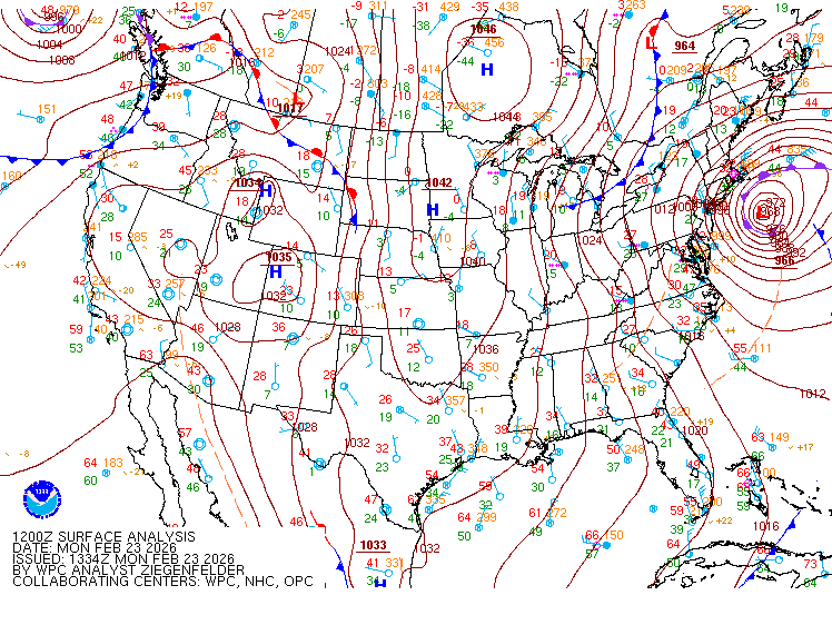
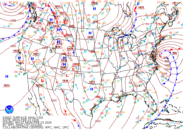
0300Z Surface Analysis
-
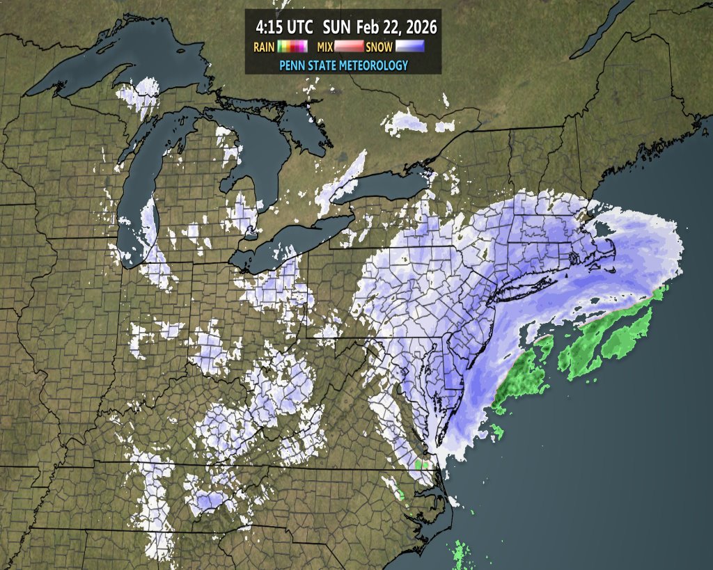
Solid snow shield

-
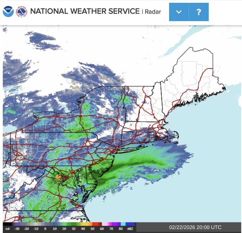
Radar: bands spiraling in from the SE to NW https://weather.cod.edu/satrad/nexrad/?parms=DIX-N0Q-1-6-100-usa-rad Radar, time sensitive
-
Regional Weather Roundup National Weather Service New York NY 1100 PM EST SUN FEB 22 2026 Note: "FAIR" indicates few or no clouds below 12,000 feet with no significant weather and/or obstructions to visibility. NYZ071-072-176-178-NJZ106-104-230500- New York City Metro Area CITY SKY/WX TMP DP RH WIND PRES REMARKS Central Park SNOW 30 30 100 NE13G29 29.74F VSB 1/4 WCI 20 World Trd Ctr NOT AVBL Bronx Lehman C N/A 32 32 100 N20G36 N/A WCI 20 LaGuardia Arpt SNOW 31 30 96 N22G33 29.72F VSB 1/2 WCI 18 Queens College N/A 32 32 100 NE20G32 N/A WCI 20 Kennedy Intl SNOW 31 30 96 N26G39 29.69F VSB 1/2 WCI 17 Breezy Point N/A N/A N/A N/A N24G35 N/A Brooklyn Coll N/A 32 32 100 N22G35 N/A WCI 19 Staten Island N/A 32 32 100 N16G28 N/A WCI 21 Newark/Liberty HVY SNOW 31 29 92 N23G33 29.73F VSB 1/4 WCI 18 Teterboro HVY SNOW 30 29 96 N17G26 29.73F VSB 1/4 WCI 18 $$ NYZ177-179-078>081-230500- Long Island New York CITY SKY/WX TMP DP RH WIND PRES REMARKS Jones Beach N/A 32 N/A N/A N30G41 N/A WCI 18 Wantagh N/A 32 32 100 N17G33 N/A WCI 21 Hempstead NOT AVBL Matinecock Pt N/A 32 N/A N/A N36G43 N/A WCI 16 Farmingdale LGT SNOW 31 29 92 N28G44 29.65F VSB 3/4 WCI 17 MacArthur/ISP SNOW 31 29 92 NE23G41 29.64F VSB 1/2 WCI 18 Stony Brook N/A 32 32 100 NE9G22 N/A WCI 24 Shirley FOG 31 31 100 NE10G24 29.68F VSB 1 WCI 22 Mt Sinai Harb N/A N/A N/A N/A N21G29 N/A Westhampton LGT SNOW 32 31 96 NE29G45 29.66F VSB 1 WCI 18 East Hampton LGT SNOW 32 30 94 NE18G26 29.68F WCI 20 Southold N/A 32 32 100 NE23G37 N/A WCI 19 Montauk N/A 32 32 100 NE15G32 29.70F WCI 22 $$ NYZ052-065-067-230500- Hudson Valley CITY SKY/WX TMP DP RH WIND PRES REMARKS White Plains SNOW 30 27 88 N23G37 29.72F VSB 1/2 WCI 17 Larchmont Harb N/A N/A N/A N/A N25G38 N/A Croton On Huds N/A N/A N/A N/A N8G17 N/A Somers N/A 30 28 93 N8 N/A WCI 23 Brewster N/A 30 30 100 N12 N/A WCI 21 Newburgh SNOW 28 28 100 N17 29.80F VSB 1/2 WCI 16 Montgomery LGT SNOW 30 26 85 N16G29 29.80F VSB 3/4 WCI 19 Otisville N/A 30 28 93 N7 N/A WCI 23 Warwick N/A 30 28 93 N13G24 N/A WCI 20 Suffern N/A 30 30 100 NE12G29 N/A WCI 21 Poughkeepsie SNOW 30 29 96 N10 29.83F VSB 1/2 WCI 21 Albany FLURRIES 30 26 85 NW7 29.93F WCI 23 $$ NJZ001-105-106-008-010-013-015-019>022-104-230500- New Jersey CITY SKY/WX TMP DP RH WIND PRES REMARKS Newark/Liberty HVY SNOW 31 29 92 N23G33 29.73F VSB 1/4 WCI 18 Teterboro HVY SNOW 30 29 96 N17G26 29.73F VSB 1/4 WCI 18 Caldwell LGT SNOW 31 28 89 NE12G28 29.76F VSB 3/4 WCI 22 Somerville LGT SNOW 31 28 89 N10G20 29.72F VSB 3/4 WCI 22 Linden LGT SNOW 31 29 92 NE13G20 29.73F VSB 3/4 WCI 21 Perth Amboy N/A N/A N/A N/A N20G26 N/A Sussex LGT SNOW 31 25 78 NE14G24 29.78F WCI 21 Andover N/A 29 26 89 N7 29.76F WCI 22 Trenton FOG 30 28 92 N20G31 29.69F VSB 3/4 WCI 17 Millville FOG 30 30 100 N21G38 29.60F VSB 1/2 WCI 17 Atlantic City LGT SNOW 31 30 96 N28G45 29.53F VSB 3/4 WCI 17 Wrightstown NOT AVBL Toms River LGT SNOW 31 30 96 N25G32 29.60F FOG WCI 17 Belmar LGT SNOW 31 32 100 N20G33 29.62F VSB 3/4 WCI 19 $$ PAZ047>061-062-071-230500- Eastern Pennsylvania CITY SKY/WX TMP DP RH WIND PRES REMARKS Philadelphia SNOW 32 30 92 N21G31 29.70F VSB 1/2 WCI 20 Allentown LGT SNOW 30 29 96 N16 29.78F FOG WCI 19 Scranton LGT SNOW 29 26 89 NE12 29.80F FOG WCI 19 $$ CTZ002-004>006-009-010-012-RIZ004-006-007-MAZ004-011-015-230500- Southern New England In CT CITY SKY/WX TMP DP RH WIND PRES REMARKS Bradley Intl LGT SNOW 30 29 96 N16G24 29.84F VSB 3/4 WCI 19 Hartford SNOW 30 30 100 N14G26 29.82F VSB 1/2 WCI 19 Danbury LGT SNOW 31 26 82 NE14G25 N/A VSB 1 WCI 21 Wtrbury/Oxford SNOW 28 27 96 N22G30 29.74F VSB 1/2 WCI 14 Norwalk Harbor N/A N/A N/A N/A N25 N/A Bridgeport SNOW 31 29 92 N21G31 29.73F VSB 1/2 WCI 18 Meriden SNOW 30 30 100 N15G28 29.78F VSB 1/2 WCI 19 New Haven SNOW 31 29 92 N18G30 29.73F VSB 1/2 WCI 19 Chester FOG 32 32 100 NE13 29.74F VSB 1/4 WCI 22 Groton LGT SNOW 32 30 92 NE17G28 29.74F VSB 1 WCI 21 Willimantic SNOW 31 30 96 NE16G22 29.80F VSB 1/2 WCI 20 In RI CITY SKY/WX TMP DP RH WIND PRES REMARKS Providence LGT SNOW 32 31 96 NE18 29.81F VSB 1 WCI 20 Block Island LGT SNOW 31 30 96 NE24G36 29.69F VSB 1 WCI 17 Westerly LGT SNOW 32 31 96 NE15G28 29.75F FOG WCI 22 In MA CITY SKY/WX TMP DP RH WIND PRES REMARKS Boston NOT AVBL Worcester HVY SNOW 27 26 96 NE15G28 29.80F VSB 1/4 WCI 15 Westfield LGT SNOW 29 28 96 N15 29.86F VSB 1 WCI 18 Provincetown CLOUDY 35 29 78 E18G29 29.86F WCI 24 Nantucket CLOUDY 35 29 78 NE28G48 29.73F WCI 22 $$
-
Public Information Statement National Weather Service New York NY 1025 PM EST Sun Feb 22 2026 ...LATEST SNOWFALL REPORTS SINCE 8 PM 2/22... Location Amount Time/Date Provider ...Connecticut... ...Fairfield County... 4 S Greenwich 5.5 in 1005 PM 02/22 Public Norwalk 5.2 in 1013 PM 02/22 Storm Chaser 1 SE Norwalk 5.2 in 1000 PM 02/22 Trained Spotter 1 SE Wilton 5.0 in 0938 PM 02/22 Public 4 SSE Easton 4.0 in 0940 PM 02/22 Public 3 WSW Shelton 4.0 in 0840 PM 02/22 Trained Spotter 1 N Norwalk 3.2 in 0924 PM 02/22 Public ...Middlesex County... 1 SW Westbrook 6.0 in 1005 PM 02/22 Trained Spotter ...New Haven County... 3 NNE East Haven 3.5 in 0930 PM 02/22 Public 3 ENE Branford 3.0 in 0903 PM 02/22 Public Meriden 2.2 in 0941 PM 02/22 Storm Chaser ...New London County... 1 SSW New London 5.0 in 1007 PM 02/22 Trained Spotter 1 SSE North Stonington 1.8 in 0857 PM 02/22 Public ...New Jersey... ...Bergen County... Leonia 7.7 in 1014 PM 02/22 Public 1 SW Franklin Lakes 7.0 in 0925 PM 02/22 Public 1 E Ridgefield 6.8 in 0955 PM 02/22 Public 1 NNW Carlstadt 6.3 in 0920 PM 02/22 Public 1 SSW River Edge 5.7 in 1008 PM 02/22 Cocorahs Fair Lawn 5.5 in 1009 PM 02/22 Trained Spotter Little Ferry 5.0 in 1000 PM 02/22 Amateur Radio 1 WSW Wallington 4.6 in 0902 PM 02/22 Trained Spotter New Milford 4.0 in 0900 PM 02/22 Trained Spotter Northvale 2.6 in 0803 PM 02/22 Public ...Essex County... North Caldwell 6.1 in 1000 PM 02/22 Amateur Radio Nutley 4.5 in 1000 PM 02/22 Amateur Radio 1 WSW Glen Ridge 4.0 in 0840 PM 02/22 Public Bloomfield 3.0 in 1000 PM 02/22 Amateur Radio ...Hudson County... Hoboken 5.3 in 0930 PM 02/22 Trained Spotter Harrison 5.0 in 0934 PM 02/22 CO-OP Observer Bayonne 4.5 in 1000 PM 02/22 Amateur Radio Kearny 3.7 in 0915 PM 02/22 Trained Spotter ...Passaic County... Clifton 3.9 in 1000 PM 02/22 Amateur Radio Wayne 3.5 in 1000 PM 02/22 Amateur Radio ...Union County... 1 SSW Westfield 6.0 in 0924 PM 02/22 Public 1 N Cranford 6.0 in 0923 PM 02/22 Public Newark Airport 4.0 in 0800 PM 02/22 Official NWS Obs ...New York... ...Kings County... 3 NW Flatbush 6.9 in 0915 PM 02/22 Public 1 WSW Gravesend 6.1 in 0832 PM 02/22 Public Crown Heights 6.0 in 0953 PM 02/22 Public 1 SE Battery Park 4.9 in 0905 PM 02/22 Emergency Mngr 1 N Bay Ridge 4.1 in 0804 PM 02/22 Public Sheepshead Bay 3.5 in 0813 PM 02/22 Trained Spotter ...Nassau County... 1 SSW Baldwin 7.0 in 0939 PM 02/22 Public East Williston 6.7 in 0929 PM 02/22 Public 1 N Syosset 6.6 in 0900 PM 02/22 Trained Spotter 1 WSW Levittown 6.2 in 1000 PM 02/22 NWS Employee 2 SSE Plainedge 6.0 in 0815 PM 02/22 Trained Spotter 1 NNW Bethpage 5.3 in 0852 PM 02/22 Public Lake Success 5.1 in 0825 PM 02/22 Public Rockville Centre 5.0 in 0922 PM 02/22 Public Manhasset Hills 3.1 in 0800 PM 02/22 Public ...New York (Manhattan) County... Washington Heights 6.3 in 0936 PM 02/22 Public ...Orange County... 1 WNW Monroe 3.5 in 0900 PM 02/22 Trained Spotter 2 SSW Middletown 2.0 in 0930 PM 02/22 Amateur Radio ...Queens County... 1 SW Bayside 7.1 in 1000 PM 02/22 Public 1 S Jackson Heights 7.0 in 1003 PM 02/22 Trained Spotter Flushing 6.0 in 0942 PM 02/22 Trained Spotter 1 NE Elmhurst 4.8 in 0800 PM 02/22 Public 1 E Fresh Meadows 4.5 in 0942 PM 02/22 Public 1 SSW Elmhurst 4.0 in 0815 PM 02/22 Public ...Richmond County... Dongan Hills 6.0 in 0800 PM 02/22 Public ...Rockland County... 1 SE Montebello 3.8 in 0836 PM 02/22 Public Nyack 3.0 in 0905 PM 02/22 Trained Spotter Thiells 2.5 in 0900 PM 02/22 Trained Spotter New City 2.2 in 0900 PM 02/22 Trained Spotter
-
Islip looks to have done well in the snowfall accumulation category today. Date/Time (L) Temp. (°F) Dew Point (°F) Relative Humidity (%) Wind Chill (°F) Wind Direction Wind Speed (mph) Visibility (miles) Weather Clouds (x100 ft) Sea Level Pressure (mb) Station Pressure (in Hg) Altimeter Setting (in Hg) 1 Hour Precip (in) 3 Hour Precip (in) 6 Hour Precip (in) 24 Hour Precip (in) Snow Depth (in) Snowfall 3 hour (in) Snowfall 6 Hour (in) Snowfall 24 Hour (in) 6 Hr Max (°F) 6 Hr Min (°F) 24 Hr Max (°F) 24 Hr Min (°F) Feb 22, 9:56 pm 31 29 92 17 NNE 25G43 0.50 Snow, Mist, Blowing snow VV005 1006.20 29.61 29.72 0.01 0.07 Feb 22, 9:50 pm 30 30 100 17 NNE 23G30 1.00 Lt snow, Mist VV006 29.62 29.73 0.01 Feb 22, 9:45 pm 30 30 100 17 NNE 23G30 1.00 Lt snow, Mist VV006 29.62 29.73 Feb 22, 9:40 pm 30 30 100 17 NNE 21G28 1.00 Lt snow, Mist VV006 29.63 29.74 Feb 22, 9:35 pm 30 30 100 16 NNE 24G36 0.75 Lt snow, Mist VV006 29.64 29.75 Feb 22, 9:30 pm 30 30 100 16 NNE 24 0.50 Snow, Mist VV005 29.64 29.75 Feb 22, 9:25 pm 30 28 93 17 NNE 22 0.50 Snow, Mist VV005 29.63 29.74 Feb 22, 9:20 pm 30 30 100 17 NNE 22 0.50 Snow, Mist VV005 29.64 29.75 Feb 22, 9:15 pm 30 30 100 17 NNE 21 0.50 Snow, Mist VV005 29.65 29.76 Feb 22, 9:10 pm 30 30 100 18 NNE 20 0.50 Lt snow, Mist VV006 29.66 29.77 Feb 22, 9:05 pm 30 30 100 17 NNE 23 0.50 Lt snow, Mist VV006 29.65 29.76 Feb 22, 9:00 pm 30 30 100 17 NNE 23G32 0.50 Lt snow, Mist VV006 29.65 29.76 Feb 22, 8:56 pm 31 30 96 18 NNE 22G31 0.50 Lt snow, Mist, Blowing snow VV006 1008.10 29.66 29.77 0.02 Feb 22, 8:55 pm 30 30 100 17 NNE 22 0.50 Lt snow, Mist VV006 29.66 29.77 0.02 Feb 22, 8:53 pm 30 30 100 17 NE 22G31 0.50 Lt snow, Mist, Blowing snow VV006 29.67 29.78 0.02 Feb 22, 8:50 pm 30 30 100 17 NNE 23 0.75 Lt snow, Mist VV006 29.67 29.78 0.02 Feb 22, 8:45 pm 30 30 100 17 NE 21G28 0.75 Lt snow, Mist VV004 29.67 29.78 0.02 Feb 22, 8:40 pm 30 30 100 17 NNE 22G28 0.75 Lt snow, Mist VV004 29.67 29.78 0.02 Feb 22, 8:35 pm 30 30 100 17 NE 22G29 0.50 Snow, Freezing Fog VV004 29.68 29.79 0.01 Feb 22, 8:30 pm 30 30 100 18 NE 18 0.50 Snow, Freezing Fog VV004 29.68 29.79 0.01 Feb 22, 8:25 pm 30 28 93 18 NNE 18 0.50 Snow, Freezing Fog VV004 29.68 29.79 0.01 Feb 22, 8:20 pm 30 28 93 18 NNE 18 0.50 Snow, Freezing Fog VV004 29.68 29.79 0.01 Feb 22, 8:15 pm 30 30 100 18 NNE 18 0.50 Snow, Freezing Fog VV004 29.69 29.80 Feb 22, 8:10 pm 30 30 100 17 NNE 21 0.25 Hvy snow, Freezing Fog VV003 29.69 29.80 Feb 22, 8:05 pm 30 28 93 18 NNE 17 0.25 Hvy snow, Freezing Fog VV003 29.69 29.80 Feb 22, 8:00 pm 30 28 93 18 NNE 18G26 0.25 Hvy snow, Freezing Fog VV003 29.69 29.80 Feb 22, 7:56 pm 30 30 100 17 NNE 22G32 0.25 Hvy snow, Freezing Fog VV003 1009.30 29.70 29.81 0.04 Feb 22, 7:55 pm 30 30 100 17 NNE 22G31 0.25 Hvy snow, Freezing Fog VV003 29.70 29.81 0.04 Feb 22, 7:50 pm 30 30 100 17 NNE 21G30 0.25 Hvy snow, Freezing Fog VV003 29.70 29.81 0.04 Feb 22, 7:45 pm 30 30 100 19 NE 16 0.25 Hvy snow, Freezing Fog VV003 29.71 29.82 0.03 Feb 22, 7:40 pm 30 30 100 18 NE 17 0.25 Hvy snow, Freezing Fog VV003 29.72 29.83 0.03 Feb 22, 7:35 pm 30 30 100 18 NE 18G25 0.25 Hvy snow, Freezing Fog VV003 29.72 29.83 0.02 Feb 22, 7:31 pm 31 30 96 19 NE 17G29 0.25 Hvy snow, Freezing Fog VV003 29.72 29.83 0.01 Feb 22, 7:30 pm 30 30 100 18 NE 18G26 0.50 Snow, Freezing Fog VV005 29.72 29.83 0.01 Feb 22, 7:25 pm 30 30 100 19 NE 16 0.50 Snow, Freezing Fog VV005 29.72 29.83 0.01 Feb 22, 7:20 pm 30 30 100 19 NE 16 0.50 Snow, Freezing Fog VV005 29.72 29.83 0.01 Feb 22, 7:15 pm 30 30 100 18 NE 18G25 0.50 Snow, Freezing Fog VV005 29.72 29.83 0.01 Feb 22, 7:10 pm 30 30 100 18 NE 17 0.50 Snow, Freezing Fog VV005 29.72 29.83 0.01 Feb 22, 7:05 pm 30 30 100 20 NE 14 0.75 Lt snow, Mist VV006 29.72 29.83 Feb 22, 7:00 pm 30 30 100 18 ENE 17 0.75 Lt snow, Mist VV006 29.73 29.84 Feb 22, 6:56 pm 31 30 96 21 NE 14G28 0.75 Lt snow, Mist VV006 1010.30 29.73 29.84 0.02 0.07 2.0 33 31 Feb 22, 6:55 pm 30 30 100 19 NE 16 0.75 Lt snow, Mist VV006 29.73 29.84 0.02 Feb 22, 6:50 pm 30 30 100 18 NE 18 0.50 Snow, Freezing Fog VV005 29.73 29.84 0.02 Feb 22, 6:45 pm 30 30 100 18 NE 20 0.50 Snow, Freezing Fog VV006 29.72 29.83 0.02 Feb 22, 6:40 pm 30 30 100 18 NE 20G29 0.50 Snow, Freezing Fog VV006 29.72 29.83 0.01 Feb 22, 6:35 pm 30 30 100 18 NE 20 0.50 Snow, Freezing Fog VV006 29.73 29.84 0.01 Feb 22, 6:30 pm 30 28 93 19 ENE 15G22 0.75 Lt snow, Mist VV008 29.75 29.86 0.01 Feb 22, 6:25 pm 30 28 93 19 NE 16 0.75 Lt snow, Mist VV008 29.75 29.86 0.01 Feb 22, 6:20 pm 30 30 100 18 NE 17 0.75 Lt snow, Mist VV007 29.74 29.85 0.01 Feb 22, 6:15 pm 30 30 100 18 NE 18 0.75 Lt snow, Mist VV007 29.73 29.84 0.01 Feb 22, 6:10 pm 30 30 100 16 NE 24G30 0.50 Snow, Freezing Fog VV006 29.73 29.84 0.01 Feb 22, 6:05 pm 30 28 93 18 NE 20G26 0.50 Snow, Freezing Fog VV006 29.74 29.85 Feb 22, 6:00 pm 30 28 93 18 ENE 18 0.50 Snow, Freezing Fog VV006 29.75 29.86 Feb 22, 5:56 pm 31 30 96 19 NE 20G31 0.50 Snow, Freezing Fog VV006 1010.90 29.74 29.85 0.02 Feb 22, 5:55 pm 30 30 100 18 NE 20G26 0.50 Snow, Freezing Fog VV006 29.74 29.85 0.02 Feb 22, 5:50 pm 30 28 93 17 NE 21 0.50 Snow, Freezing Fog VV006 29.73 29.84 0.02 Feb 22, 5:45 pm 30 28 93 17 NE 23G33 0.50 Snow, Freezing Fog VV007 29.72 29.83 0.02 Feb 22, 5:40 pm 30 30 100 18 NE 20G29 0.50 Snow, Freezing Fog VV007 29.74 29.85 0.01 Feb 22, 5:35 pm 30 30 100 18 NE 18 0.50 Snow, Freezing Fog VV007 29.75 29.86 0.01 Feb 22, 5:30 pm 30 30 100 19 NE 15G22 0.50 Snow, Freezing Fog VV006 29.77 29.88 0.01 Feb 22, 5:25 pm 30 30 100 20 NE 14 0.50 Snow, Freezing Fog VV006 29.78 29.89 0.01 Feb 22, 5:20 pm 30 30 100 21 ENE 12 0.50 Snow, Freezing Fog VV007 29.79 29.90 0.01 Feb 22, 5:15 pm 30 30 100 20 NE 14 0.50 Snow, Freezing Fog VV007 29.79 29.90 0.01 Feb 22, 5:10 pm 30 30 100 19 NE 15 0.75 Lt snow, Mist VV007 29.78 29.89 Feb 22, 5:05 pm 30 28 93 19 NE 15G21 0.75 Lt snow, Mist VV008 29.78 29.89 Feb 22, 5:00 pm 30 28 93 19 NE 15 0.75 Lt snow, Mist VV008 29.79 29.90 Feb 22, 4:56 pm 31 29 92 20 ENE 15G26 0.75 Lt snow, Mist VV008 1012.40 29.79 29.90 0.01 Feb 22, 4:55 pm 30 28 93 20 ENE 14G20 0.75 Lt snow, Mist VV008 29.79 29.90 Feb 22, 4:53 pm 30 28 93 19 ENE 16G26 0.75 Lt snow, Mist VV009 29.79 29.90 T Feb 22, 4:50 pm 30 28 93 19 ENE 16 1.00 Lt snow, Mist SCT009 OVC012 29.79 29.90 Feb 22, 4:45 pm 30 28 93 18 ENE 17 1.00 Lt snow, Mist SCT009 OVC013 29.80 29.91 Feb 22, 4:40 pm 30 28 93 19 ENE 15G21 1.00 Lt snow, Mist SCT009 OVC013 29.80 29.91 Feb 22, 4:35 pm 30 28 93 19 ENE 16G26 1.00 Lt snow, Mist SCT009 OVC013 29.80 29.91 Feb 22, 4:30 pm 32 28 86 23 ENE 13G18 1.00 Lt snow, Mist SCT009 OVC013 29.81 29.92 Feb 22, 4:25 pm 32 28 86 22 ENE 15 1.25 Lt snow, Mist SCT009 OVC014 29.81 29.92 Feb 22, 4:20 pm 30 28 93 19 ENE 15 1.25 Lt snow, Mist SCT009 OVC014 29.80 29.91 Feb 22, 4:15 pm 30 28 93 19 ENE 15 1.25 Lt snow, Mist SCT009 OVC014 29.80 29.91 Feb 22, 4:10 pm 30 28 93 19 ENE 15 1.25 Lt snow, Mist SCT009 OVC014 29.79 29.90 Feb 22, 4:05 pm 30 28 93 19 NE 15 1.50 Lt snow, Mist SCT009 BKN014 OVC024 29.79 29.90 Feb 22, 4:00 pm 30 28 93 20 NE 14 1.50 Lt snow, Mist SCT009 BKN014 OVC024 29.80 29.91 Feb 22, 3:56 pm 31 29 92 20 NE 16G24 1.50 Lt snow, Mist SCT009 BKN014 OVC024 1013.30 29.81 29.92 0.01 0.02 Feb 22, 3:55 pm 30 28 93 20 NE 14G21 1.50 Lt snow, Mist SCT009 BKN014 OVC024 29.82 29.93 0.01 Feb 22, 3:50 pm 32 28 86 21 ENE 16 1.50 Lt snow, Mist FEW009 BKN014 OVC023 29.82 29.93 Feb 22, 3:45 pm 32 28 86 21 ENE 16 1.50 Lt snow, Mist FEW009 BKN014 OVC023 29.82 29.93 Feb 22, 3:41 pm 32 29 88 22 ENE 15G23 1.50 Lt snow, Mist FEW009 BKN014 OVC023 29.82 29.93 T Feb 22, 3:40 pm 32 28 86 23 ENE 13G21 2.00 Lt snow, Mist FEW009 BKN014 OVC023 29.83 29.94 Feb 22, 3:35 pm 32 28 86 23 ENE 13G20 2.00 Lt snow, Mist FEW009 BKN014 OVC025 29.83 29.94 Feb 22, 3:30 pm 32 28 86 22 ENE 14 3.00 Lt snow, Mist FEW009 BKN014 OVC025 29.83 29.94 Feb 22, 3:25 pm 32 28 86 21 NE 16 3.00 Lt snow, Mist FEW009 BKN014 OVC025 29.83 29.94 Feb 22, 3:20 pm 32 28 86 22 ENE 14 4.00 Lt snow, Mist SCT009 BKN014 OVC049 29.84 29.95 Feb 22, 3:15 pm 32 28 86 22 ENE 15G25 4.00 Lt snow, Mist SCT009 BKN014 OVC049 29.84 29.95 Feb 22, 3:10 pm 32 28 86 22 ENE 14G20 4.00 Lt snow, Mist SCT009 BKN014 OVC049 29.84 29.95 Feb 22, 3:05 pm 32 28 86 22 ENE 15 3.00 Lt snow, Mist SCT009 BKN014 OVC049 29.84 29.95 Feb 22, 3:00 pm 32 28 86 24 ENE 10 4.00 Lt snow, Mist SCT009 BKN014 OVC049 29.84 29.95 Feb 22, 2:56 pm 32 29 88 22 ENE 15G23 2.50 Lt snow, Mist SCT009 BKN014 OVC049 1014.50 29.85 29.96 T Feb 22, 2:55 pm 32 28 86 22 ENE 14 4.00 Lt snow, Mist SCT009 BKN014 OVC049 29.85 29.96 Feb 22, 2:50 pm 34 28 80 25 ENE 13 4.00 Lt snow, Mist BKN009 BKN012 OVC040 29.86 29.97 Feb 22, 2:45 pm 34 28 80 25 ENE 13 4.00 Lt snow, Mist BKN009 BKN012 OVC040 29.86 29.97 Feb 22, 2:40 pm 34 28 80 24 ENE 14G20 4.00 Lt snow, Mist BKN009 OVC015 29.86 29.97 Feb 22, 2:35 pm 34 28 80 26 ENE 10 4.00 Lt snow, Mist BKN009 OVC015 29.87 29.98 Feb 22, 2:30 pm 34 28 80 25 ENE 12 4.00 Lt snow, Mist BKN009 OVC015 29.87 29.98 Feb 22, 2:25 pm 32 28 86 23 ENE 13 4.00 Lt snow, Mist BKN009 OVC015 29.88 29.99 Feb 22, 2:20 pm 32 28 86 24 ENE 10 2.00 Lt snow, Mist BKN009 OVC015 29.87 29.98 Feb 22, 2:15 pm 32 28 86 23 ENE 12G18 2.00 Lt snow, Mist BKN009 OVC015 29.87 29.98 Feb 22, 2:10 pm 32 28 86 23 ENE 13G21 2.00 Lt snow, Mist BKN009 OVC015 29.88 29.99 Feb 22, 2:05 pm 32 28 86 24 ENE 10 2.00 Lt snow, Mist BKN009 OVC015 29.88 29.99 Feb 22, 2:00 pm 32 30 93 22 ENE 14 2.00 Lt snow, Mist BKN009 OVC015 29.88 29.99 Feb 22, 1:56 pm 32 30 92 23 E 13 2.00 Lt snow, Mist BKN008 BKN015 OVC021 1015.80 29.89 30.00 0.01 Feb 22, 1:55 pm 32 30 93 23 E 12 2.00 Lt snow, Mist BKN008 BKN015 OVC021 29.89 30.00 0.01 Feb 22, 1:50 pm 32 30 93 23 E 12 0.75 Lt snow, Mist BKN015 OVC017 29.89 30.00 0.01 Feb 22, 1:45 pm 32 30 93 23 ENE 13 0.75 Lt snow, Mist BKN015 OVC017 29.89 30.00 0.01 Feb 22, 1:40 pm 32 30 93 24 E 10G16 0.75 Lt snow, Mist BKN015 OVC017 29.89 30.00 0.01 Feb 22, 1:35 pm 32 30 93 23 ENE 12 0.75 Lt snow, Mist BKN015 OVC017 29.88 29.99 0.01 Feb 22, 1:30 pm 32 30 93 23 E 12 0.75 Lt snow, Mist BKN015 OVC017 29.88 29.99 0.01 Feb 22, 1:25 pm 32 30 93 22 E 14 0.75 Lt snow, Mist BKN015 OVC017 29.89 30.00 0.01 Feb 22, 1:20 pm 32 30 93 22 E 14 0.75 Lt snow, Mist BKN015 OVC017 29.90 30.01 Feb 22, 1:15 pm 32 30 93 24 E 10 0.75 Lt snow, Mist BKN015 OVC017 29.90 30.01 Feb 22, 1:10 pm 34 30 86 26 E 9 0.75 Lt snow, Mist BKN015 OVC017 29.91 30.02 Feb 22, 1:05 pm 34 30 86 25 E 12 0.75 Lt snow, Mist BKN015 OVC017 29.91 30.02 Feb 22, 1:00 pm 34 30 86 26 E 10 0.75 Lt snow, Mist BKN015 OVC017 29.91 30.02 Feb 22, 12:56 pm 33 30 88 25 E 10 0.75 Lt snow, Mist BKN015 OVC022 1016.70 29.91 30.02 0.01 0.01 36 33 Feb 22, 12:55 pm 34 30 86 25 E 12 0.75 Lt snow, Mist BKN015 OVC022 29.92 30.03 0.01 Feb 22, 12:53 pm 34 30 86 26 E 9 0.75 Lt snow, Mist BKN015 OVC022 29.92 30.03 0.01 Feb 22, 12:50 pm 34 30 86 26 E 10 0.75 Lt snow, Mist BKN015 OVC022 29.92 30.03 Feb 22, 12:45 pm 34 30 86 26 E 9 1.00 Lt snow, Mist BKN015 OVC022 29.92 30.03 Feb 22, 12:40 pm 34 30 86 25 E 13 1.00 Lt snow, Mist BKN015 OVC022 29.92 30.03 Feb 22, 12:35 pm 34 30 86 25 E 12G17 1.00 Lt snow, Mist BKN015 OVC022 29.92 30.03 Feb 22, 12:30 pm 34 30 86 25 E 13 1.50 Lt snow, Mist BKN015 OVC022 29.93 30.04 Feb 22, 12:25 pm 34 30 86 26 E 9 2.00 Lt snow, Mist BKN016 OVC022 29.93 30.04 Feb 22, 12:20 pm 34 30 86 25 E 12 2.00 Lt snow, Mist BKN016 OVC022 29.93 30.04 Feb 22, 12:15 pm 34 30 86 25 E 12 2.00 Lt snow, Mist BKN018 OVC022 29.93 30.04 Feb 22, 12:10 pm 34 30 86 26 E 10 2.00 Lt snow, Mist BKN018 BKN024 OVC029 29.93 30.04 Feb 22, 12:05 pm 34 28 80 25 E 12 1.75 Lt snow BKN018 BKN024 OVC029 29.93 30.04 Feb 22, 12:00 pm 34 28 80 24 E 15 1.75 Lt snow BKN018 BKN024 OVC028 29.93 30.04 Feb 22, 11:56 am 34 29 82 24 E 15G26 1.50 Lt snow BKN018 OVC028 1017.30 29.93 30.04 T Feb 22, 11:55 am 36 28 75 26 E 15 3.00 Lt snow BKN018 OVC028 29.93 30.04 Feb 22, 11:50 am 36 28 75 25 E 17 3.00 Lt snow BKN018 OVC028 29.93 30.04 Feb 22, 11:45 am 36 28 75 25 E 17 4.00 Lt snow BKN019 OVC027 29.93 30.04 Feb 22, 11:40 am 36 28 75 26 E 15 7.00 Lt snow BKN019 OVC027 29.94 30.05 Feb 22, 11:35 am 36 28 75 25 E 17 9.00 Lt snow BKN019 OVC027 29.94 30.05 Feb 22, 11:30 am 36 28 75 28 E 12G17 9.00 Lt snow BKN019 OVC027 29.94 30.05 Feb 22, 11:25 am 36 28 75 27 E 13 9.00 Lt snow BKN019 OVC027 29.94 30.05 Feb 22, 11:20 am 36 28 75 25 E 17 9.00 Lt snow BKN019 OVC026 29.94 30.05 Feb 22, 11:15 am 36 28 75 25 E 17 9.00 Lt snow BKN019 OVC026 29.94 30.05 Feb 22, 11:10 am 36 28 75 26 E 15 9.00 Lt snow BKN019 OVC026 29.95 30.06 Feb 22, 11:05 am 36 28 75 27 E 13 9.00 Lt snow OVC019 29.94 30.05 Feb 22, 11:00 am 36 28 75 26 E 16 9.00 Lt snow BKN019 OVC025 29.94 30.05 Feb 22, 10:56 am 36 28 73 26 ESE 16G23 9.00 Lt snow BKN017 OVC025 1017.80 29.95 30.06 T Feb 22, 10:55 am 36 28 75 27 E 14G21 9.00 Lt snow BKN017 OVC025 29.95 30.06 Feb 22, 10:50 am 36 28 75 26 E 15G21 9.00 Lt snow OVC014 29.95 30.06 Feb 22, 10:45 am 36 28 75 28 E 10 9.00 Lt snow OVC014 29.95 30.06 Feb 22, 10:40 am 36 28 75 25 E 17 9.00 Lt snow OVC014 29.95 30.06 Feb 22, 10:35 am 36 28 75 28 E 12 9.00 Lt snow OVC014 29.95 30.06 Feb 22, 10:30 am 36 28 75 27 E 13 9.00 Lt snow OVC014 29.95 30.06 Feb 22, 10:25 am 36 28 75 28 E 12G18 9.00 Lt snow OVC014 29.95 30.06 Feb 22, 10:20 am 36 28 75 28 E 12 9.00 Lt snow OVC014 29.96 30.07 Feb 22, 10:15 am 36 28 75 27 E 14 9.00 Lt snow OVC014 29.96 30.07 Feb 22, 10:10 am 36 30 80 26 E 15 9.00 Lt snow OVC014 29.96 30.07 Feb 22, 10:05 am 36 30 80 29 E 9 9.00 Lt snow OVC014 29.96 30.07
-
Heavy snow and freezing fog reported at Central Park at 10 PM February 22, 2026. Date/Time (L) Temp. (°F) Dew Point (°F) Relative Humidity (%) Wind Chill (°F) Wind Direction Wind Speed (mph) Visibility (miles) Weather Clouds (x100 ft) Sea Level Pressure (mb) Station Pressure (in Hg) Altimeter Setting (in Hg) 1 Hour Precip (in) 3 Hour Precip (in) 6 Hour Precip (in) 24 Hour Precip (in) 6 Hr Max (°F) 6 Hr Min (°F) 24 Hr Max (°F) 24 Hr Min (°F) Feb 22, 9:51 pm 31 30 96 22 NNE 12G26 0.25 Hvy snow, Freezing Fog VV005 1007.80 29.61 29.78 0.10 0.33 Feb 22, 8:51 pm 31 30 96 22 NE 12G26 0.25 Snow, Freezing Fog VV005 1009.30 29.66 29.83 0.11 Feb 22, 7:51 pm 31 30 96 21 NE 13G26 0.25 Snow, Freezing Fog VV006 1010.40 29.69 29.86 0.12 Feb 22, 6:51 pm 31 30 96 22 NE 12G23 0.25 Snow, Freezing Fog VV006 1011.20 29.71 29.88 0.07 0.21 32 30 Feb 22, 5:51 pm 30 29 96 20 NE 13G29 0.25 Snow, Freezing Fog OVC006 1011.00 29.71 29.88 0.08 Feb 22, 4:51 pm 31 29 92 19 ENE 17G33 0.25 Lt snow, Freezing Fog OVC008 1012.60 29.75 29.92 0.02 Feb 22, 3:51 pm 31 30 96 20 ENE 15G31 0.50 Lt snow, Freezing Fog OVC007 1013.10 29.77 29.94 0.02 0.04 Feb 22, 2:51 pm 31 30 96 19 ENE 18G33 0.25 Lt snow, Freezing Fog OVC006 1013.80 29.79 29.96 0.02 Feb 22, 1:51 pm 32 30 92 22 ENE 14G25 1.25 Lt snow, Mist OVC007 1015.60 29.84 30.01 T Feb 22, 12:51 pm 32 30 92 22 ENE 15G24 0.75 Lt snow, Mist OVC007 1016.20 29.86 30.03 0.02 0.10 34 32 Feb 22, 11:51 am 32 30 92 22 ENE 15G24 0.50 Lt snow, Fog OVC006 1017.00 29.88 30.05 0.02 Feb 22, 10:51 am 32 31 96 25 NE 8G18 0.75 Lt snow, Mist OVC006 1017.30 29.89 30.06 0.02 Feb 22, 9:51 am 33 31 92 25 ENE 10G20 1.25 Lt snow, Mist OVC005 1017.60 29.90 30.07 0.01 0.04 Feb 22, 8:51 am 34 32 92 27 NE 9 3.00 Lt snow, Mist OVC005 1018.20 29.92 30.09 0.01 Feb 22, 7:51 am 34 32 92 27 E 8 2.00 Lt snow, Mist OVC006 1018.80 29.94 30.11 0.02 Feb 22, 6:51 am 35 32 88 29 ENE 7 6.00 Lt rain, Mist OVC006 1018.40 29.93 30.10 T T
-
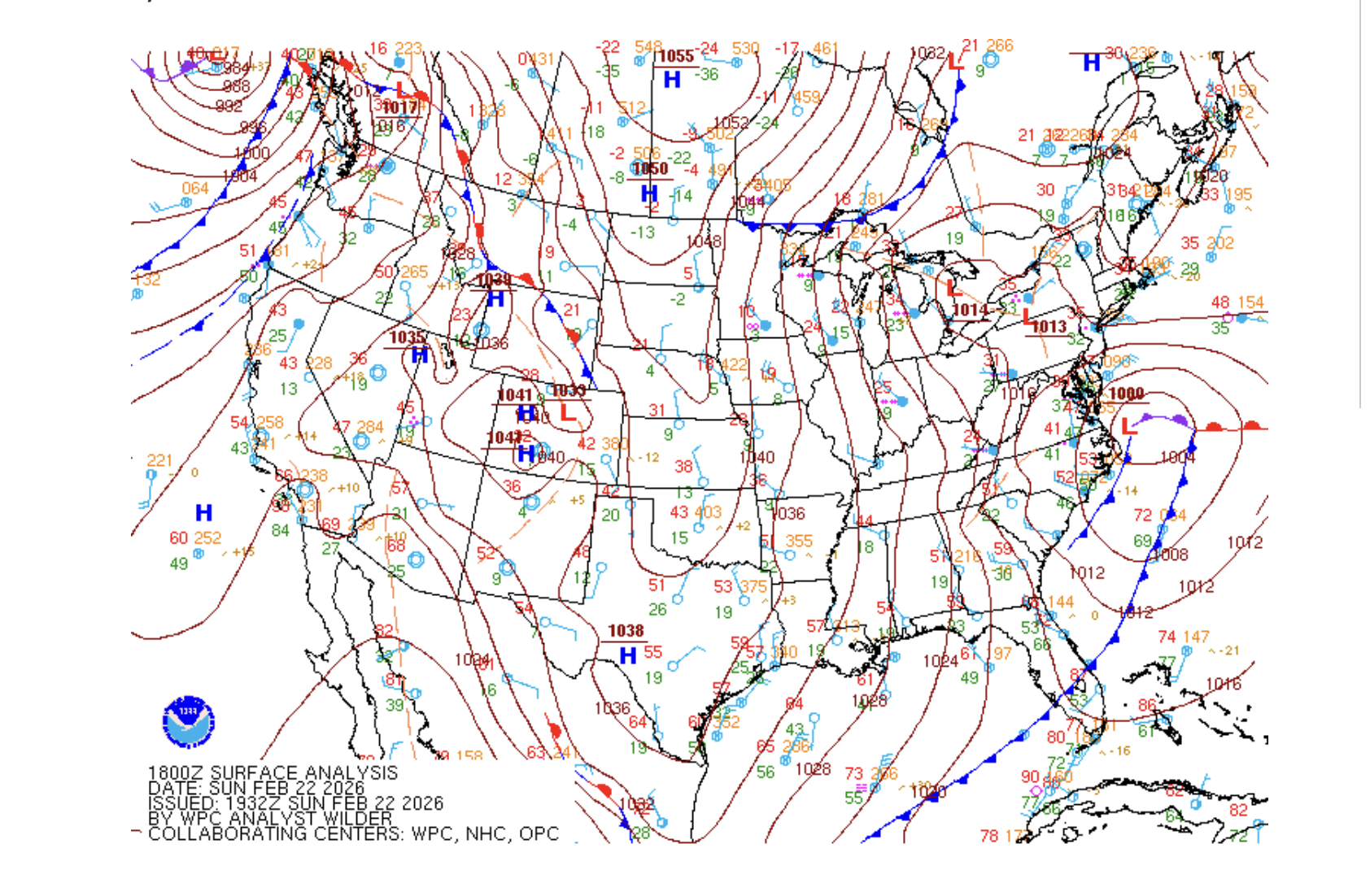
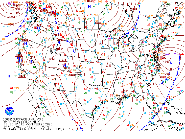
00z Surface Analysis, low at 992 millibars
-
NYC Central Park 6:00 PM February 22, 2026. Temp down to 30, pressure falling fast and snow intensity increased from past hour. Date/Time (L) Temp. (°F) Dew Point (°F) Relative Humidity (%) Wind Chill (°F) Wind Direction Wind Speed (mph) Visibility (miles) Weather Clouds (x100 ft) Sea Level Pressure (mb) Station Pressure (in Hg) Altimeter Setting (in Hg) 1 Hour Precip (in) 3 Hour Precip (in) 6 Hour Precip (in) 24 Hour Precip (in) 6 Hr Max (°F) 6 Hr Min (°F) 24 Hr Max (°F) 24 Hr Min (°F) Feb 22, 5:51 pm 30 29 96 20 NE 13G29 0.25 Snow, Freezing Fog OVC006 1011.00 29.71 29.88 0.08
-
-
its paid for the more advance features
-
No worries, all is good.
-
-
436 PM EST Sun Feb 22 2026 NWS Special Weather Statement ***Moderate to Heavy Snow Early This Evening*** Bands of moderate to heavy snow will move across the area through 8pm. Snowfall rates will increase to one half to one inch per hour in the heaviest snow. Conditions will begin deteriorating, especially after sunset, as temperatures continue falling below freezing. This will allow the snow to accumulate on all surfaces. Travel is not recommended as roads will become snow covered and hazardous.
-
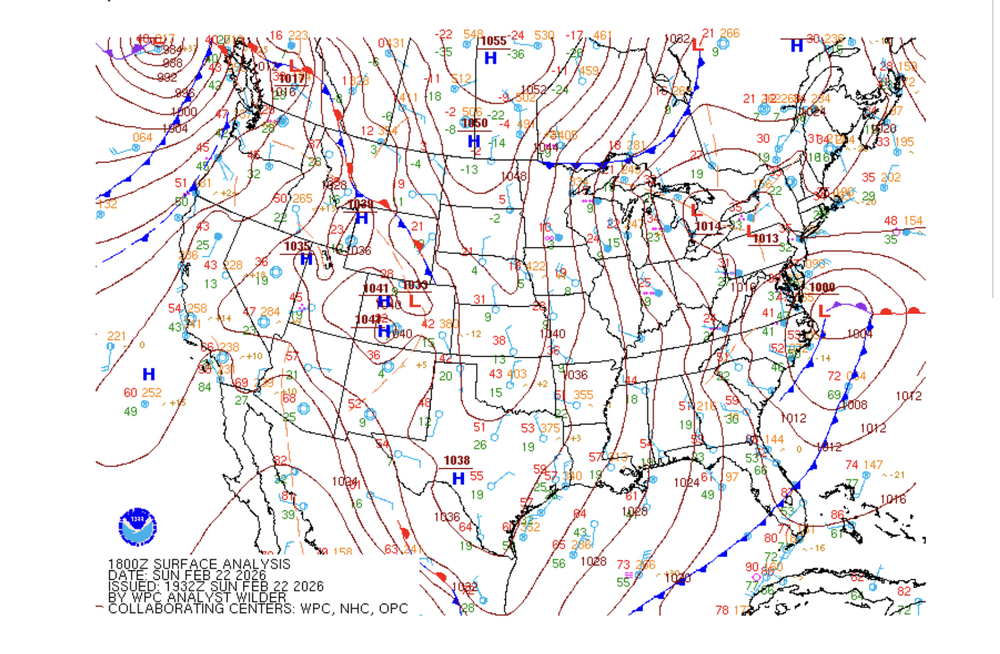
18Z Surface Analysis
-
.AVIATION /21Z SUNDAY THROUGH FRIDAY/... -- Changed Discussion --3:32 February 22, 2026 **HIGH IMPACT WINTER STORM INTO MONDAY** Conditions continue deteriorating this evening with snow overspreading the terminals from south to north. The snow intensity ramps up after 00z with blizzard conditions expected with 1/4SM visibilities and strong wind gusts. The snow intensity should start weakening on Monday with snow ending from west to east Monday afternoon. LIFR/VLIFR overnight and Monday morning. Improvements to MVFR likely Monday afternoon. Areas of blowing snow likely tonight into Monday. NE winds increase through this evening, becoming 15-20kt with gusts 25-30 kt after sunset, then quickly ramping up to 25-35 kt with gusts 35-45 kt overnight into Monday morning. The strongest winds will occur for NYC metro terminals, Long Island and southern CT terminals. Gusts 50-55 kt possible at KJFK, KLGA, KISP, KBDR and KGON late tonight into Monday morning. LLWS also expected tonight and early Monday morning with wind speeds at 2kft 50-60 kt. Total Forecast Snow Amounts KJFK/KLGA/KEWR: 18-22 inches KISP: 20-24 inches
-
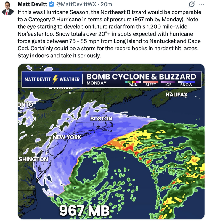
posted again if no one put it up earlier: .DISCUSSION... -- Changed Discussion --3:32 PM February 22, 2026 .KEY MESSAGE 1... A potential historic blizzard will impact the Tri-State area into Monday. This is a dangerous situation with conditions deteriorating quickly this evening into tonight. A potent upper level shortwave can be seen digging down towards the southeast coast on latest water vapor satellite imagery. Out ahead of it, surface cyclogenesis is underway and right on track off the Mid-Atlantic coast as seen in latest surface obs and even on visible satellite. While little wobbles in track/qpf trends were seen in some 12z guidance, there is still excellent agreement on this low rapidly intensifying to an impressive ~970mb central pressure before passing somewhere near the 40N/70W benchmark Monday morning. While the latest 12z GFS is now lower with QPF and more in line with the Canadian and ECMWF, these global models are struggling with banding. Current forecast QPF and Snow Amounts remained similar to previous forecast which is more in line with hi res/HREF guidance. Snow amount was derived using similar snow ratios to the previous forecast. Much of the guidance including the NBM appears to be too high. This was manually adjusted down to 10:1 or even a bit lower today, then increasing to 12-14:1 by late tonight into daybreak Monday as colder air wraps around the system. Using these ratios with generally 1.25 to 1.50 inches of QPF across the interior and 1.75 to 2.00 inches along the coast resulted in a swath of about 20 to 24 inches of snow for NYC and Long Island and 16 to 20 inches elsewhere. While this is the expected amount, a few isolated readings of 30 inches are possible in the heaviest banding, mainly along the coast. As for winds, the forecast remained the same for much of the area. Out east, for eastern LI and southern New London, confidence increased enough to bump up a few knots. There will likely be a brief period here where a 65-70kt LLJ at 950mb will aid in isolated 70 mph gusts at the surface. As a general timeline for how this will play out: Light snow will continue over the next few hours with little impact, especially because of marginal surface temperatures. However, conditions rapidly deteriorate this evening into tonight, with heavy snow and 1/4 mile visibility expected by around 7pm. Through the night, winds will continue to increase as heavy snow bands work through the area. White out conditions are expected during this time resulting in traveling becoming dangerous, if not impossible. Given latest hi res/HREF guidance and model time heights of impressive lift in the DGZ, snowfall rates in the heaviest bands will likely be 2 inches per hour for the coast and 1-2 inches per hours inland. Brief rates of 3 inches in one hour is not out of the question. Conditions start to gradually improve Monday afternoon although winds remain gusty. Even if we do dry out a bit earlier than forecast, blowing snow could be an issue into Monday afternoon. Have continued to keep mention of thunder out of the forecast but it can not be completely ruled out along the coast late tonight into early Monday morning. .KEY MESSAGE 2... Strengthening E-NE winds today into tonight could produce a surge of 2.5-3.5 ft, producing widespread moderate to locally major coastal flooding along the back bays of western Suffolk and srn Nassau, Peconic Bay, and western Long Island Sound, and widespread minor to locally moderate flooding in NY Harbor and Jamaica Bay, the lower Hudson River, and ern Long Island Sound. The main high tide cycle of concern is Sunday night. Areas of dune erosion are likely, with localized overwashes possible along the ocean beachfront Sunday night into Monday morning. Additional coastal flooding will likely linger into the Monday afternoon high tide cycle, with a strong northerly flow limiting impacts somewhat to minor/locally moderate categories. .KEY MESSAGE 3... As a clipper low passes to the north on Wednesday, an associated warm front should bring some light snow and rain on Wed. Accumulations should be on the light side, ranging from less than an inch across Long Island, to around an inch in NYC and along the CT coastline, to 1-2 inches north/west of there. A stronger low moving from the OH valley to the lower Great Lakes on Thu could bring more wintry precip. NBM thermal profiles were mainly supportive of snow and/or rain, while blend of 12Z GFS/00Z ECMWF thermal profiles shows temps warming aloft and are more in favor of light snow changing to a wintry mix inland, and rain in the NYC metro area and along the coast. Any snow/ice amts should be light, no more than an inch or two of snow most places and a light glaze of ice inland NW of NYC. Either way advisories could be needed for parts of the interior north/west of I-287 in NJ/NY and along the I-84 corridor in CT. High temperatures Tuesday range from the upper 20s to lower 30s, then trend closer to normal the rest of the week. This will allow for gradual snow melt each day, and with mostly sub-freezing temperatures at night into early morning, subsequent re-freeze of snow melt. -- End Changed Discussion --
-

-
Lets get that band to our south up to NYC area!
-
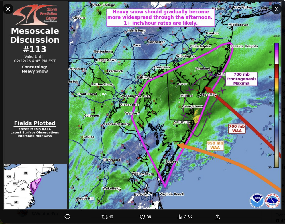
From the Storm Prediction Center
-
that radar in motion shows the storm beginning to wrap up (fill in, organize & strengthen). Moderate snow over central & southern NJ, Delaware