NJHurricane
-
Posts
2,176 -
Joined
-
Last visited
About NJHurricane

-
Blizzard of 2026 Storm Thread/OBS
NJHurricane replied to Mikeymac5306's topic in Philadelphia Region
This was around 12:40am National Park NJ, across from PHL Alright….took some measurements (misplaced my ruler had to use a tape measure) Walked down to a little used ball field located on Hessian Ave just outside Red Bank Battlefield county park (no not the Monmouth County battle) Field is large and partially shielded by home plate fencing on one end and a stand of trees on the other…. Walked out past what I estimated to be the infield and took eleven measurements around an approximately 30 foot box I walked. One on each corner, one on each side and two in the middle ish. Came up with an average depth of 10.7 inches. I drive past it every day and can confirm it was snow free at the start of the storm. -
Blizzard of 2026 Storm Thread/OBS
NJHurricane replied to Mikeymac5306's topic in Philadelphia Region
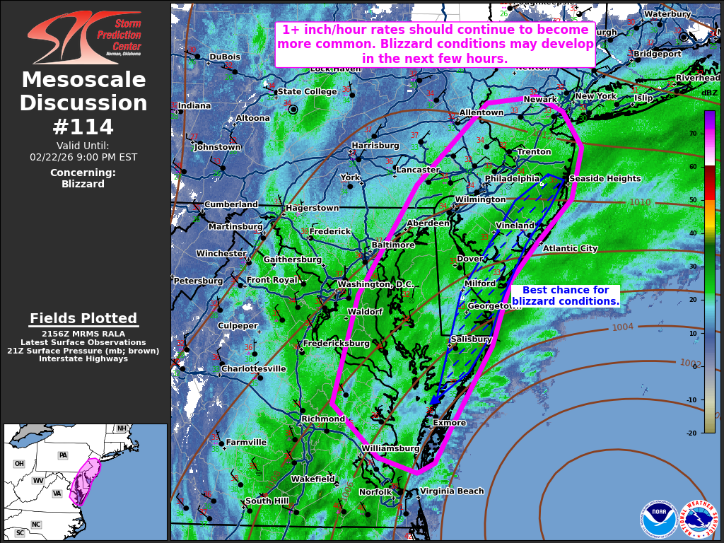
https://www.spc.noaa.gov/products/md/md0114.html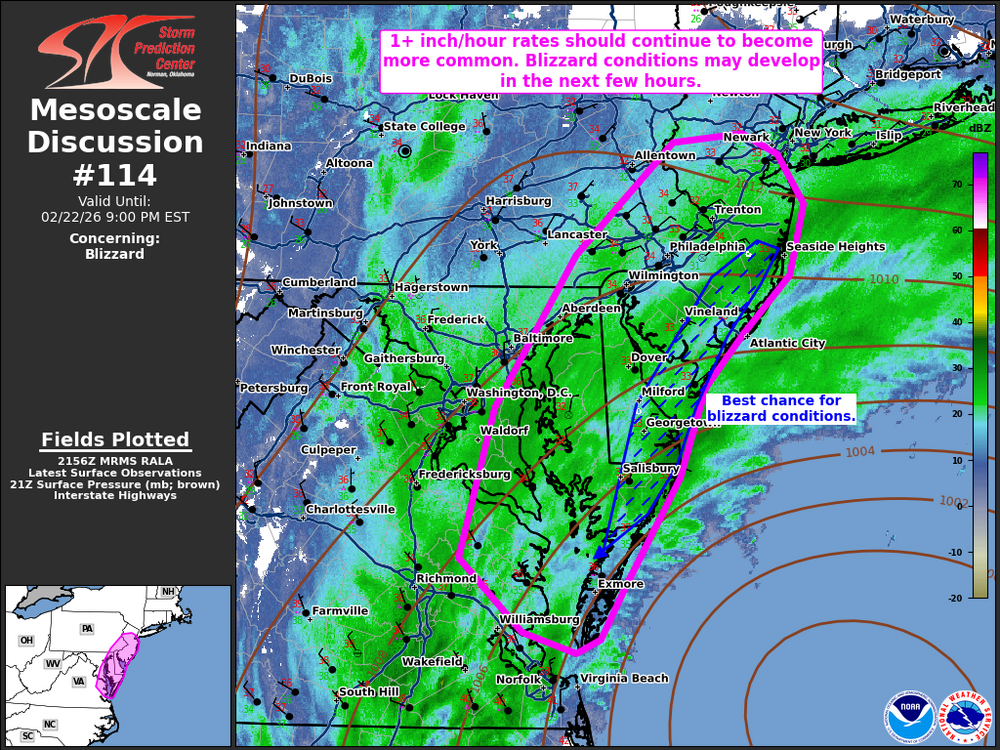
-
Blizzard of 2026 Storm Thread/OBS
NJHurricane replied to Mikeymac5306's topic in Philadelphia Region
4pm National Park NJ Across from Philadelphia International Airport Steady light to moderate snow 33f Wind picking up from the Northeast Note: Moved our cars, went inside, back out because I forgot to raise the windshield wipers, and in that one minute windshields were completely covered again -
Blizzard of 2026 Storm Thread/OBS
NJHurricane replied to Mikeymac5306's topic in Philadelphia Region
3pm National Park NJ, across from Philadelphia International Airport First mangled snowflakes mixing in with rain. Temperature: 36f -
Blizzard of 2026 Storm Thread/OBS
NJHurricane replied to Mikeymac5306's topic in Philadelphia Region
My aura when waiting for rain to change to snow
-
Blizzard of 2026 Storm Thread/OBS
NJHurricane replied to Mikeymac5306's topic in Philadelphia Region
National Park NJ, across the river from PHL 6:30 am Light rain/drizzle 36f -
If you view the Euro as being somewhat of an outlier, and GFS/NAM as being steroid outliers and weave in the other guidance, it’s a pretty reasonable forecast.
-
Never really liked it or didn’t like it as much as the GFS?
-
January 25-26 Winter Storm Potential
NJHurricane replied to Ralph Wiggum's topic in Philadelphia Region
Seems like ages since I got to see a solid warning criteria snowfall mostly falling in daylight, but here it comes. Intensity picking up in National Park NJ, looks like we are past an inch now. -
January 25-26 Winter Storm Potential
NJHurricane replied to Ralph Wiggum's topic in Philadelphia Region
6am National Park NJ Light and steady snow 3/4” accumulation Wind starting to pick up from the east northeast Temperature 14f -
Meh…what time had sleet been predicted to enter the chat?
-
January 25-26 Winter Storm Potential
NJHurricane replied to Ralph Wiggum's topic in Philadelphia Region
It’s pixie dust to start, but it’s dusting up cars and railings instantly and if you have a lighted and somewhat distant point of reference you can see the air is thick with it. -
January 25-26 Winter Storm Potential
NJHurricane replied to Ralph Wiggum's topic in Philadelphia Region
3:03 am National Park NJ Flurries/first flakes Temperature 16f -
January 25-26 Winter Storm Potential
NJHurricane replied to Ralph Wiggum's topic in Philadelphia Region
Yes….newest one mentioned nudging amounts up slightly -
That’s what she said. Hope you see many more, would bode well for me in South Jersey near Philly.