Search the Community
Showing results for tags 'wind gusts'.
Found 4 results
-
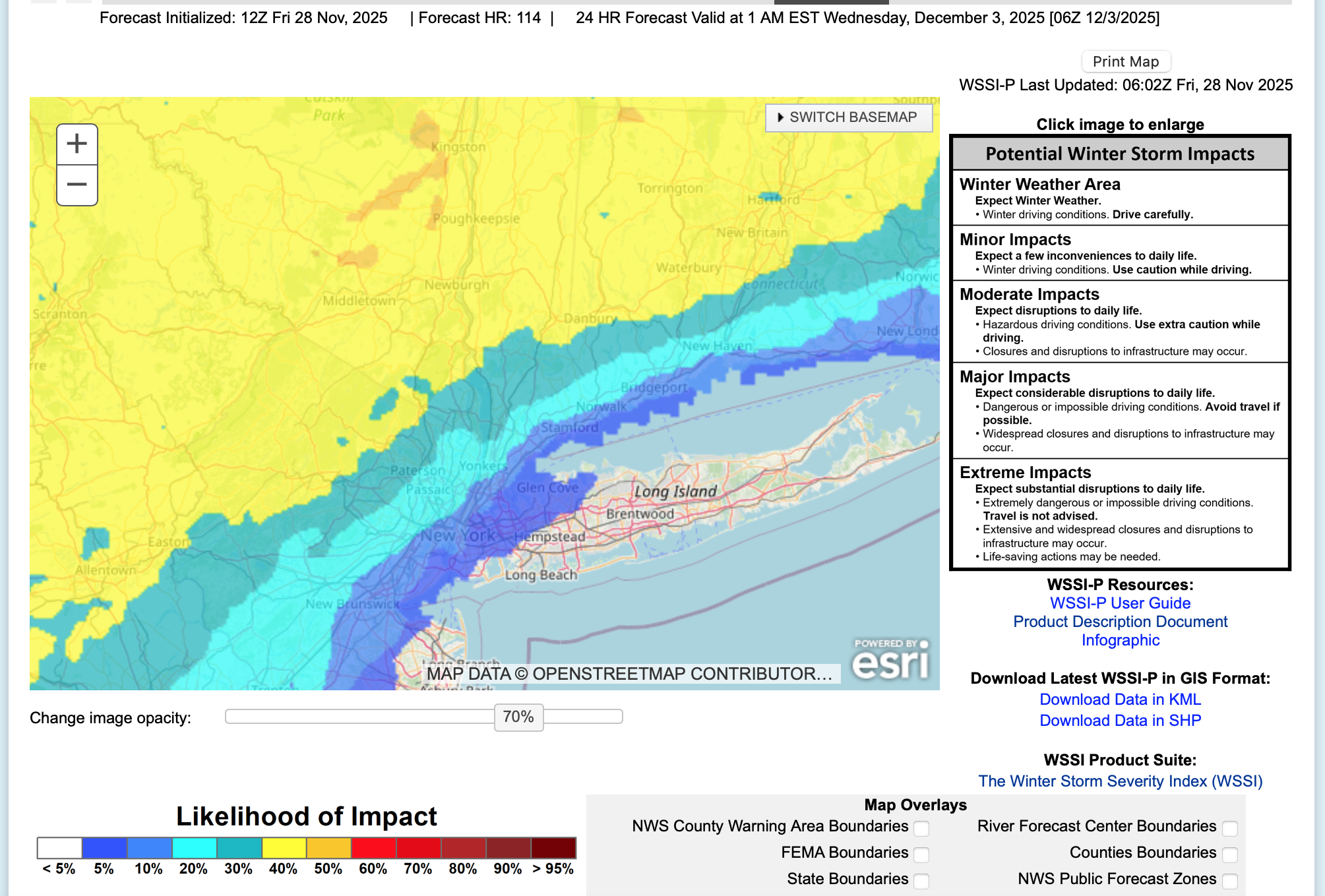
 Based on ensemble guidance seen through 06z/28, a rapidly intensifying and fast moving coastal low will bring a variety of weather elements to the NYC subforum. Periods of moderate to heavy rain are expected coastal areas- preceded by a little snow-sleet near dawn Tuesday and to closeout the storm Tuesday evening, while a period of heavy snow-sleet seems likely for the interior, especially the I84 corridor. Gusty northerly winds to 45 MPH are possible for eastern Long Island in the early Wednesday morning departure. Due to the late development and rapid departure of the storm, the chance of coastal flooding is minimal. All ensembles including ECAI have significant precipitation. This may be Central Parks first measurable snow-sleet of the season, though temps at or just above freezing at sunrise Tuesday may preclude onset measurable in the city. Delays are anticipated over the interior hilly terrain with possible school closings or early dismissals along and north of I80, especially the I84 corridor from the Poconos across se NYS into CT. One attached graphic (WSSI-P) shows the potential for a minor impact event per the NWS inputs for the their 1AM Friday forecast.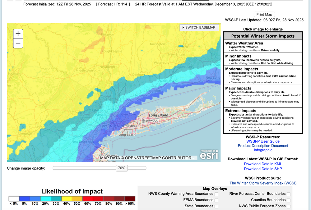
-
Not a major wind event, it still will have it's impacts- probably as the third wind event in the past three weeks. While many model gust tools do not forecast wind gusts above 45 MPH Sunday afternoon, the ECMWF gust tool does (seen on Pivotal) as do the soundings of the 00z/15 ECMWF and 06z/15 HRRR. Presuming these scattered gusts in excess of 45 MPH occur, there would be isolated power outages in our NYC subforum from a few broken tree branches or wind knocking down a few dead trees. Plan on air travel impact-delays Sunday afternoon, and possibly needing a little extra time to arrive at destinations (isolated detours?). Afternoon football games in NYS/NJ may be impacted by wind gusts? 535A/15
-
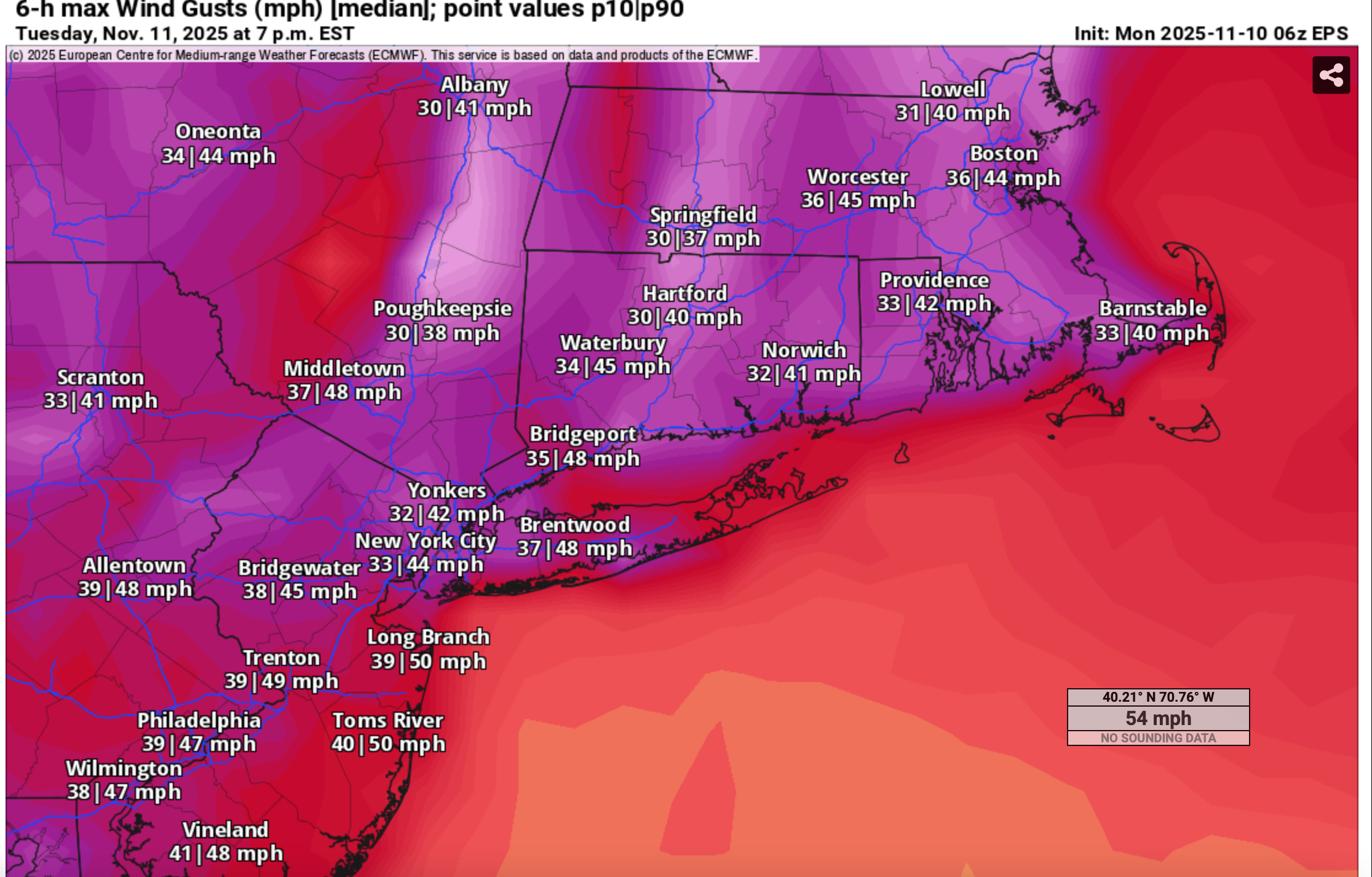
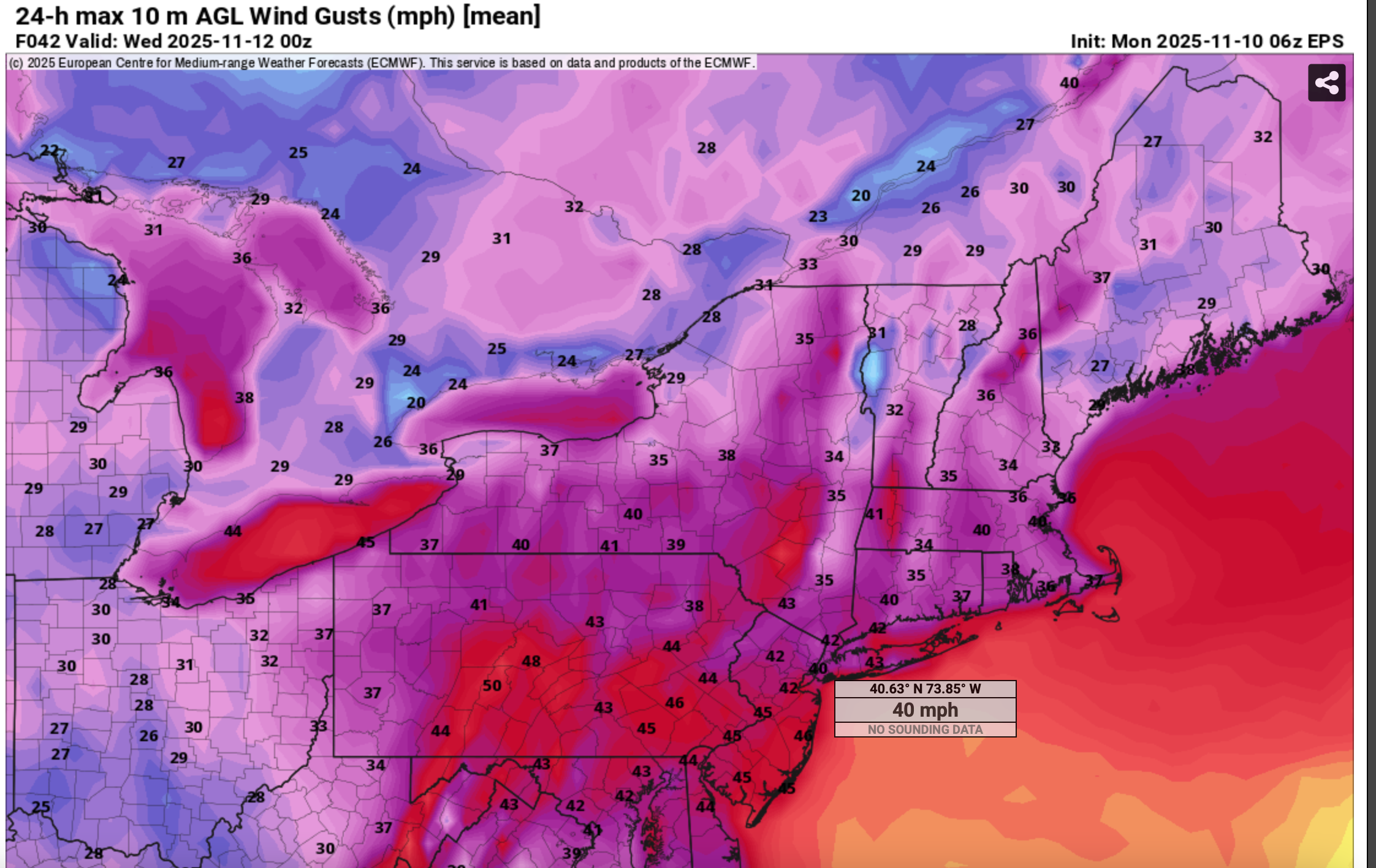
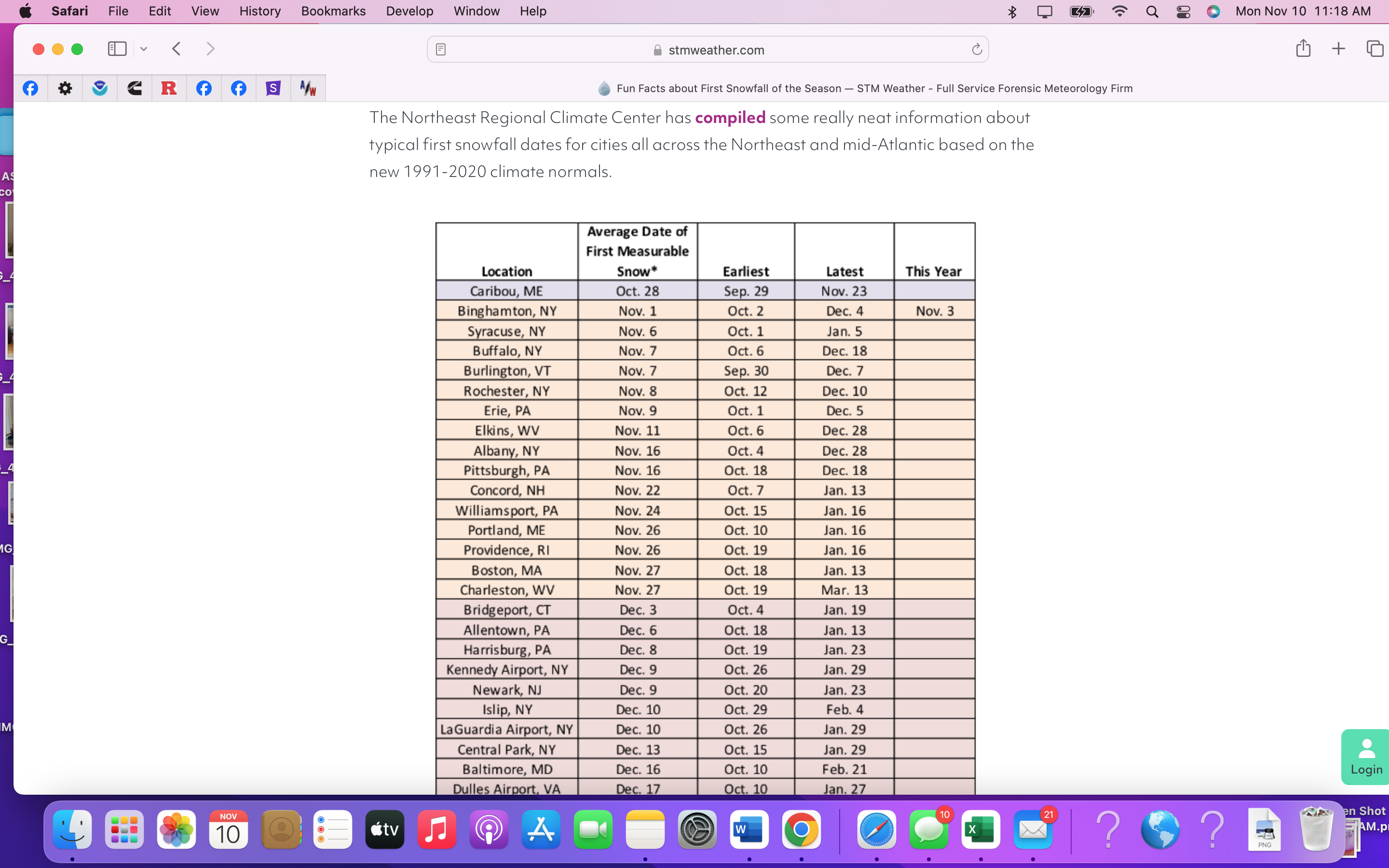
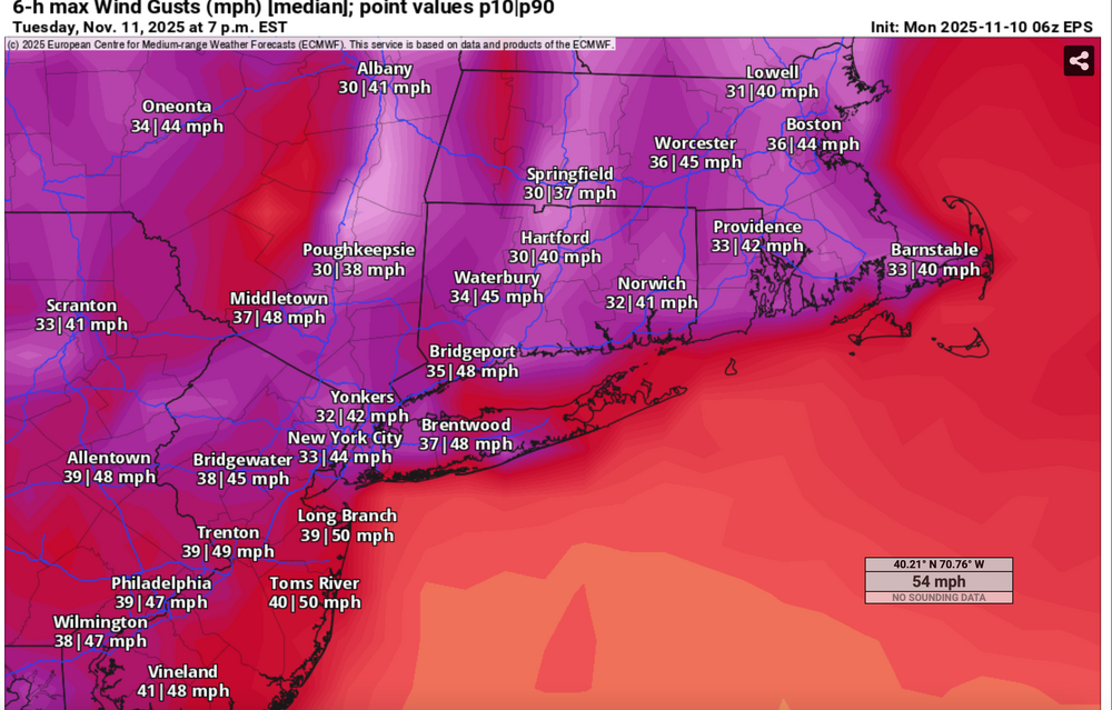
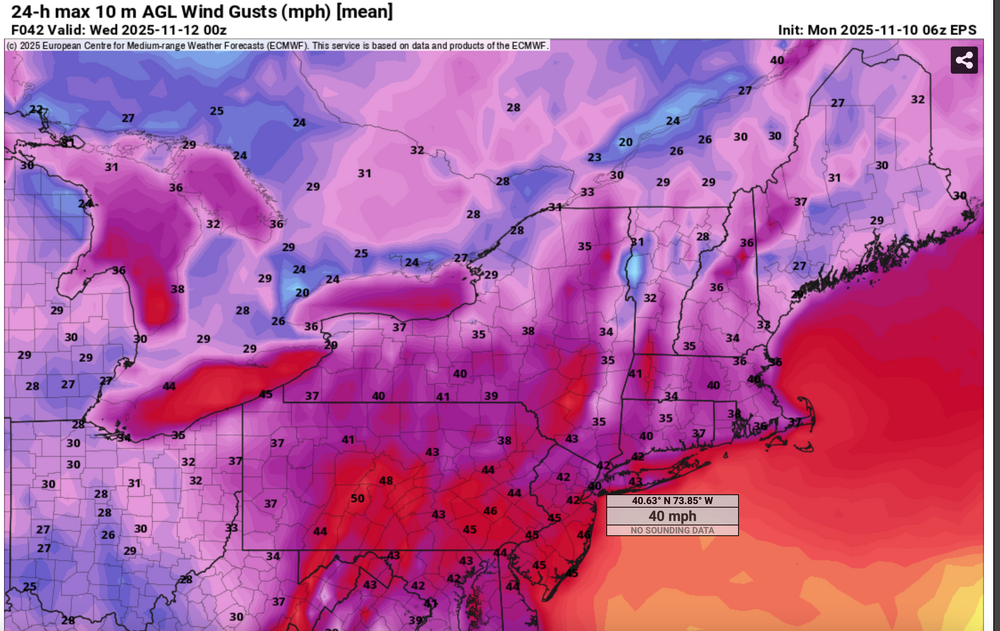
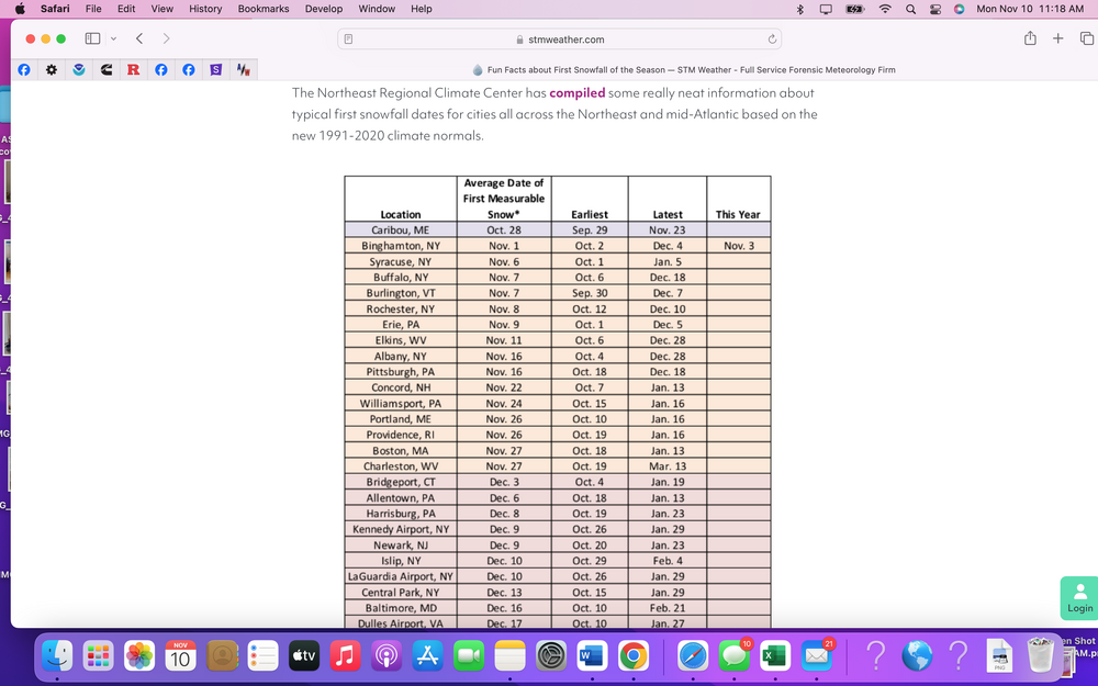
For fun, since we have modeled guidance posts the past several days of a deep highly anomalous cold unstable trough passage Tuesday. Momentum transfer via the NAM FOUS BL Wind hreshold of 27 kt and the Richardson Number as viewed on Bob Harts web pages, suggests winds do not exceed 45 MPH . However ECMWF EPS suggests marginal gusts 45-50 MPH southern part of the NYC subforum midday spreading into the NYC-Long Island and ridges above 1000 feet late in the day or evening. Impact mainly air travel and possibly isolated or scattered broken branches impeding traffic here and there. Of greater interest to the NYC subforum is the likelihood of flurries or even scattered light snow showers moving across the forum area including NYC-Li midday-afternoon. Could this be CP's first trace of snow for the 25-26 winter? 06z/10 EPS range via prob 10% (high gust) and 90% (low gust) 06z/10 median wind gust (marginal) and First measurable snow history Posted fina 1218PM/10 (0718z/10
-
Another significant weather event is headed our way, about 7-8 days after the last. By the time the first day of winter officially starts, we may see a little snow or ice for the interior and substantial rainfall that could prompt flood and coastal flood statements for our area. Sunday-Thursday "potential pair" of wet events that could eventually change to ice or wet snow, especially I84 elevations Tuesday-Wednesday. Substantial rainfall is outlooked... probably at least an inch for virtually the entire NYC subforum and possibly """isolated 6"""" worst case. Not saying 6" will occur but it's in some of the advance modeling and it could end up over the fish. Persistent northeast winds for possibly up to 4-5 days could be a coastal flood problem. A disturbance in the southwest USA today-Wednesday 12/13 migrates east, ingesting short waves from the northern stream and a juicy one out of the Gulf of Mexico. Then it apparently plods northeast along the east coast. How close the upper low comes up here before fading east is with the traditional uncertainty and TBD, but it will be interesting to monitor. There could be a significant banding signal well to the northwest of the upper low and if that upper low holds together longer and eventually makes it up to the south of LI by the start of winter., it will have produced quite bit of impact here. That is still very uncertain and not a lock. Modeling seen through 06z/13: EC-EPS is basically one and done by late Tuesday, but it even flags interior snowfall, the GEFS is most robust for wintry weather and the CMCE, a slightly warmer model, also has some wintry stuff a little further north of I84. All ensembles agree on accumulations Adirondacks. This is another El Niño event, that is particularly juicy (see FL coast pressure intensity), and has a noticeable RRQ of the upper jet near the Canadian Maritimes (southern-northern stream merge) to assist upward motion. Will there be two events next week? or just one centered on Monday? Title update 6AM Saturday from the original that follows: added Damaging gusts LI/CT. A single or pair of nor'easters Noon Sun Dec 17, 2023 - Thu evening Dec 21. Potential: flooding rain I95 corridor, persistent gusty ne wind driven tidal flooding episodes next week, change to ice or snow interior elevations by Tue morning.
- 489 replies
-
- 11
-

-

-
- flooding rains
- coastal flooding
- (and 4 more)