Search the Community
Showing results for tags 'power outages'.
Found 8 results
-
 Not a major wind event, it still will have it's impacts- probably as the third wind event in the past three weeks. While many model gust tools do not forecast wind gusts above 45 MPH Sunday afternoon, the ECMWF gust tool does (seen on Pivotal) as do the soundings of the 00z/15 ECMWF and 06z/15 HRRR. Presuming these scattered gusts in excess of 45 MPH occur, there would be isolated power outages in our NYC subforum from a few broken tree branches or wind knocking down a few dead trees. Plan on air travel impact-delays Sunday afternoon, and possibly needing a little extra time to arrive at destinations (isolated detours?). Afternoon football games in NYS/NJ may be impacted by wind gusts? 535A/15
 -
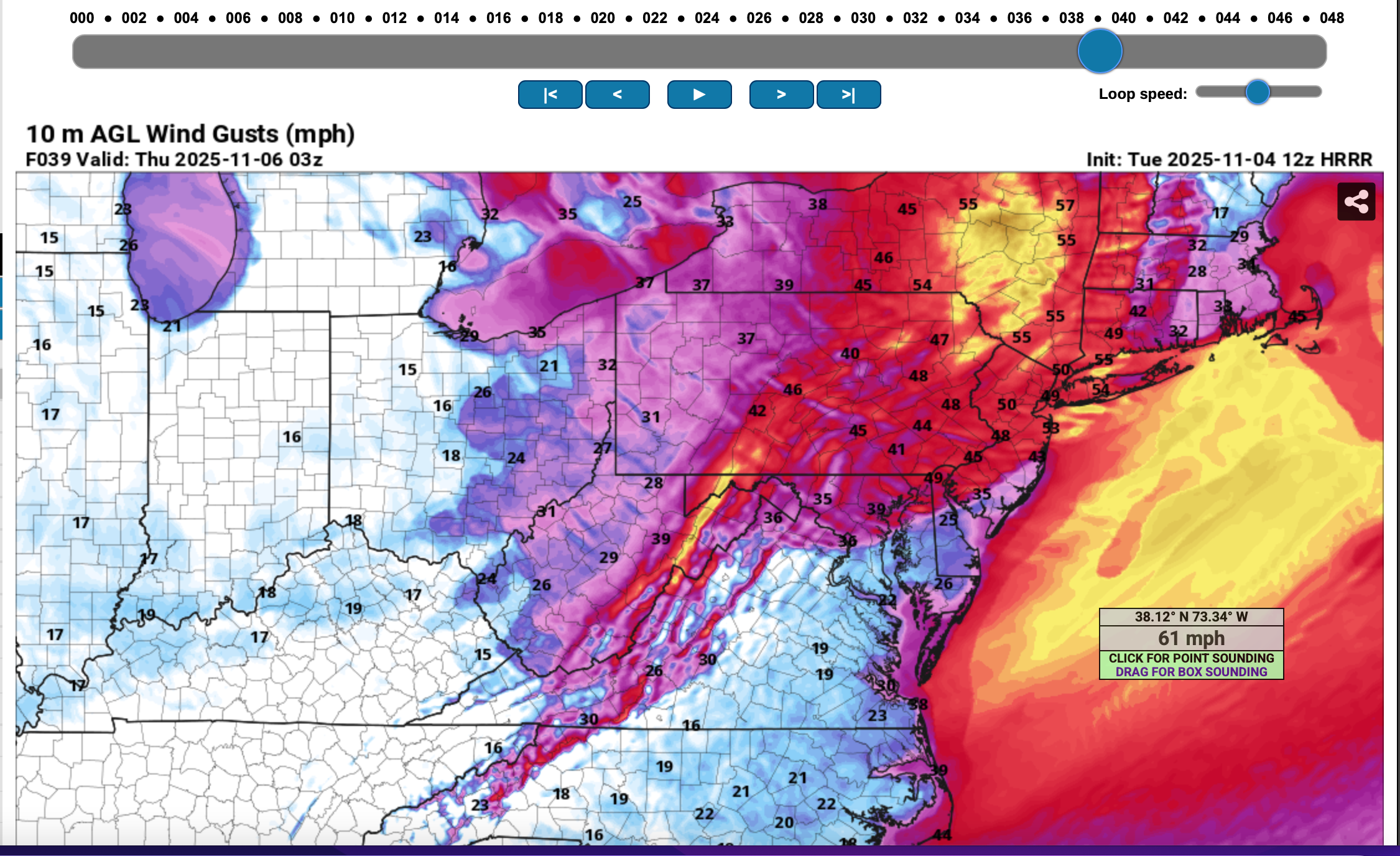
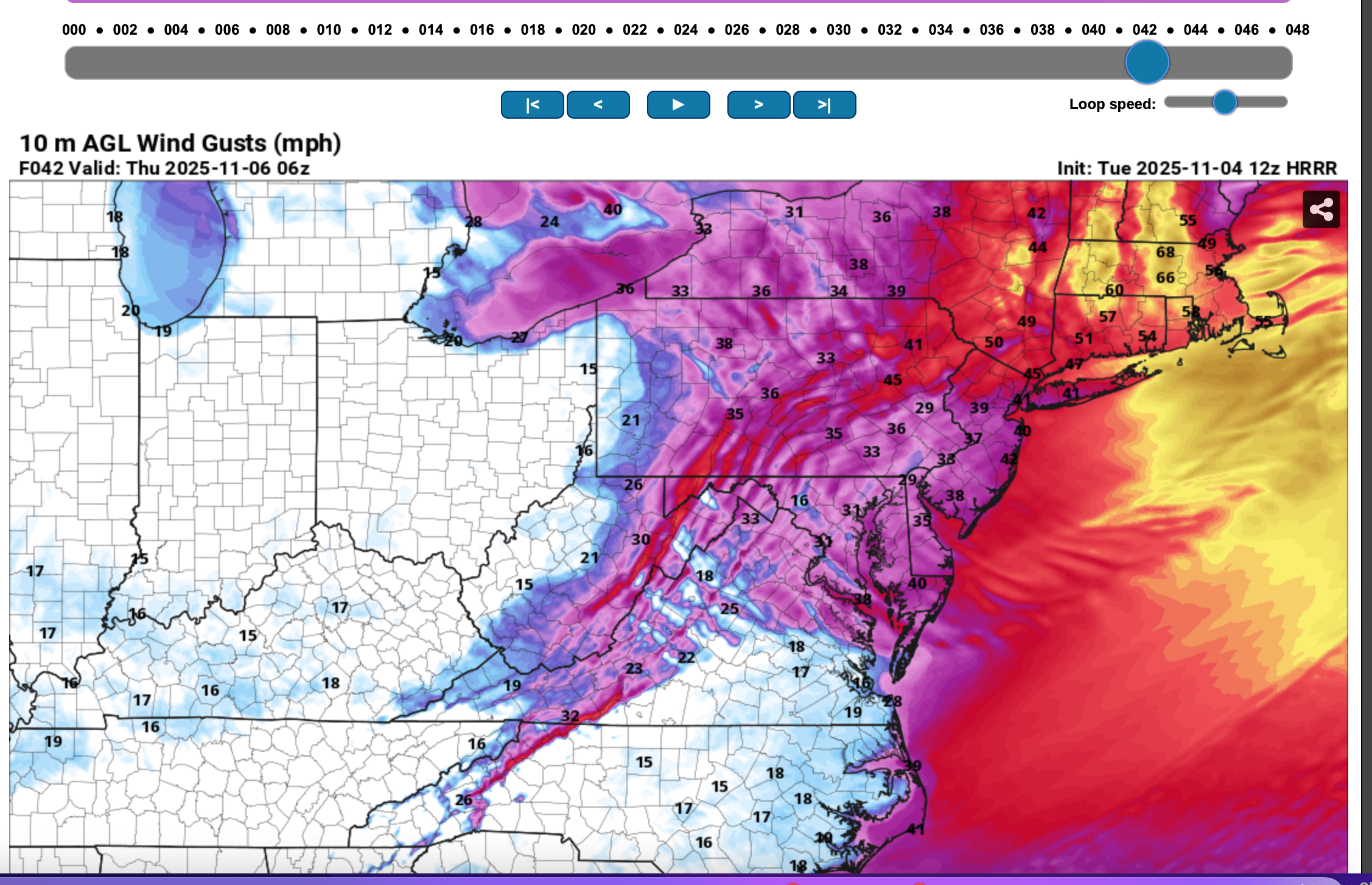
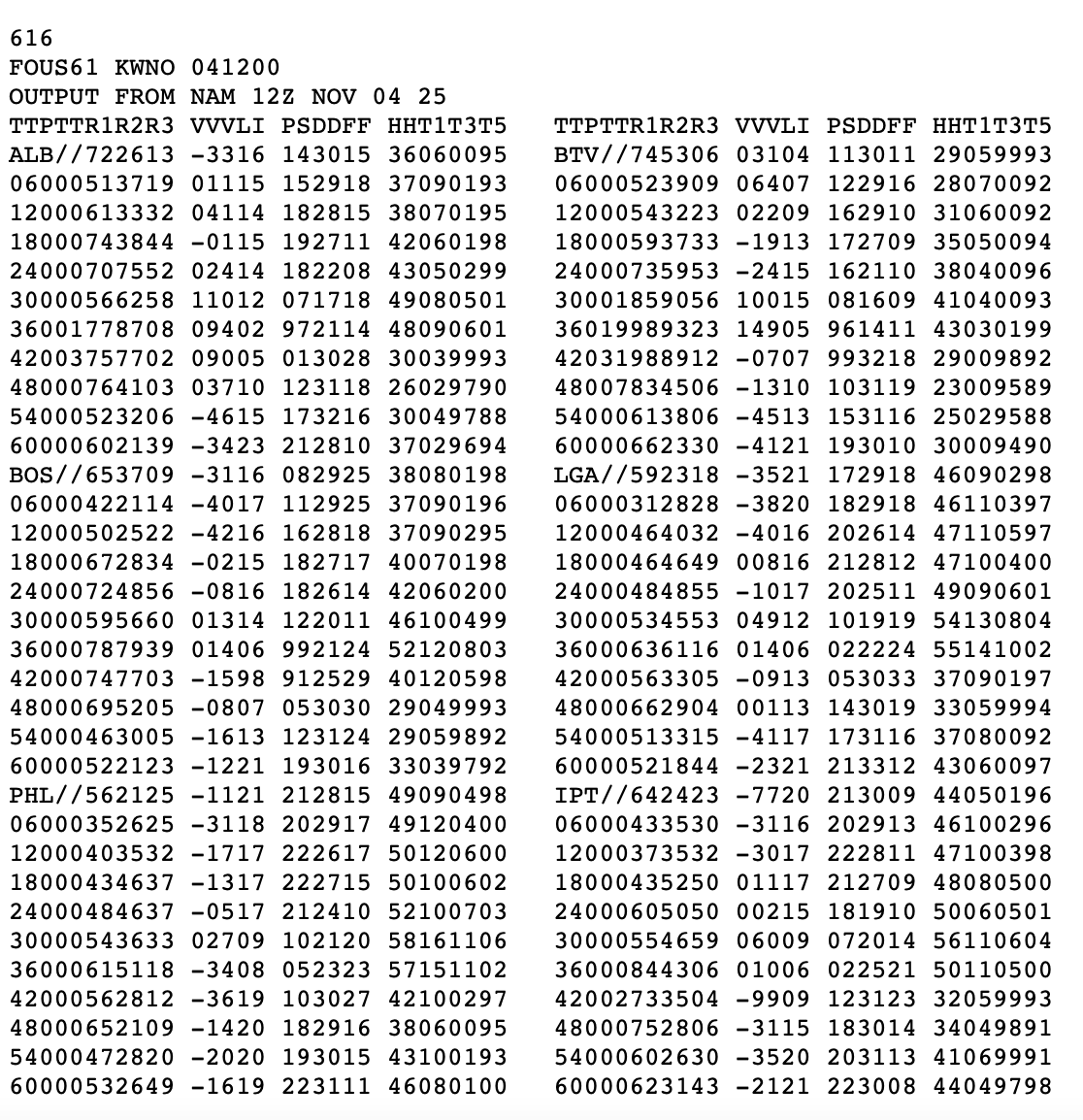
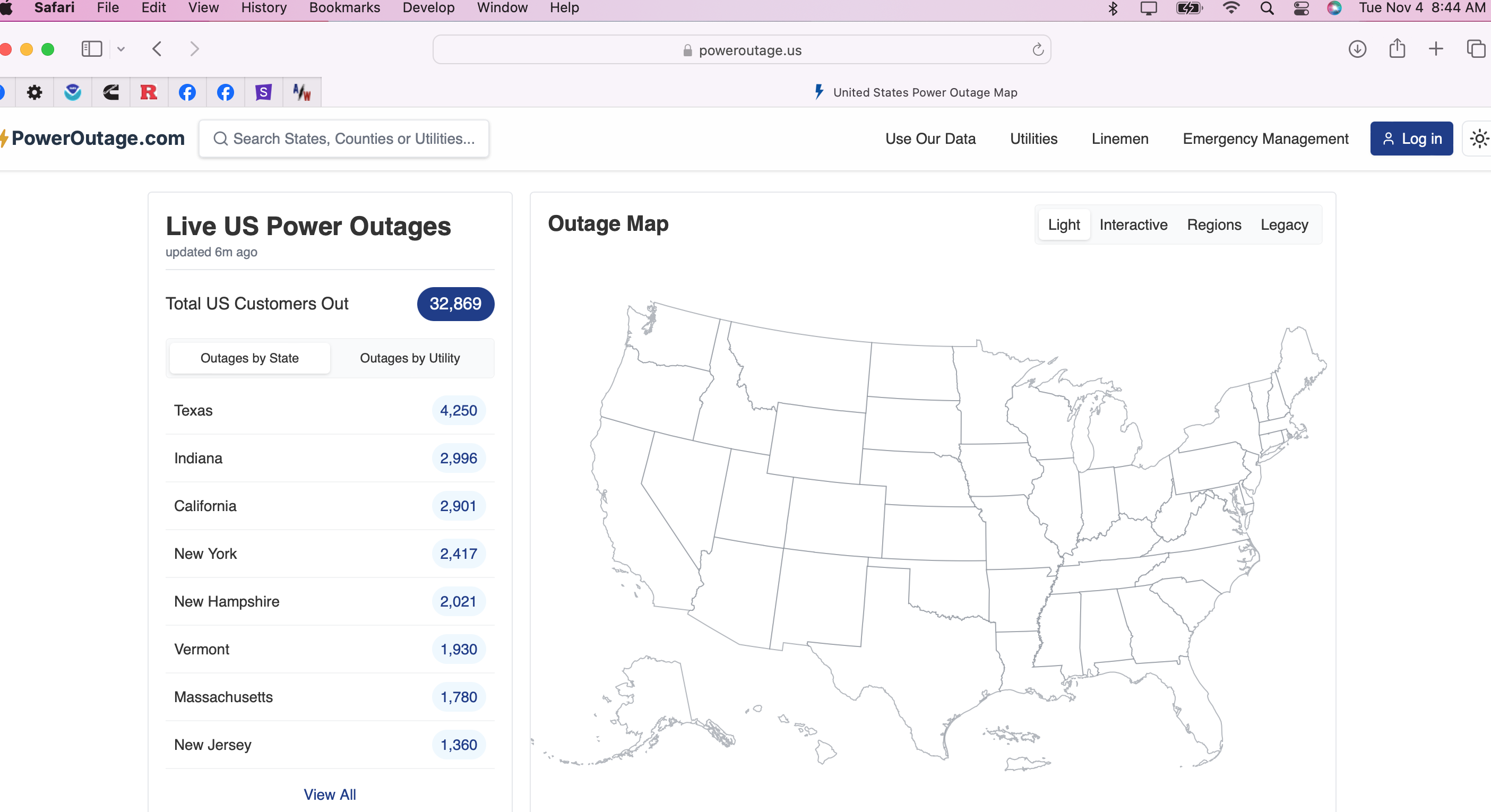
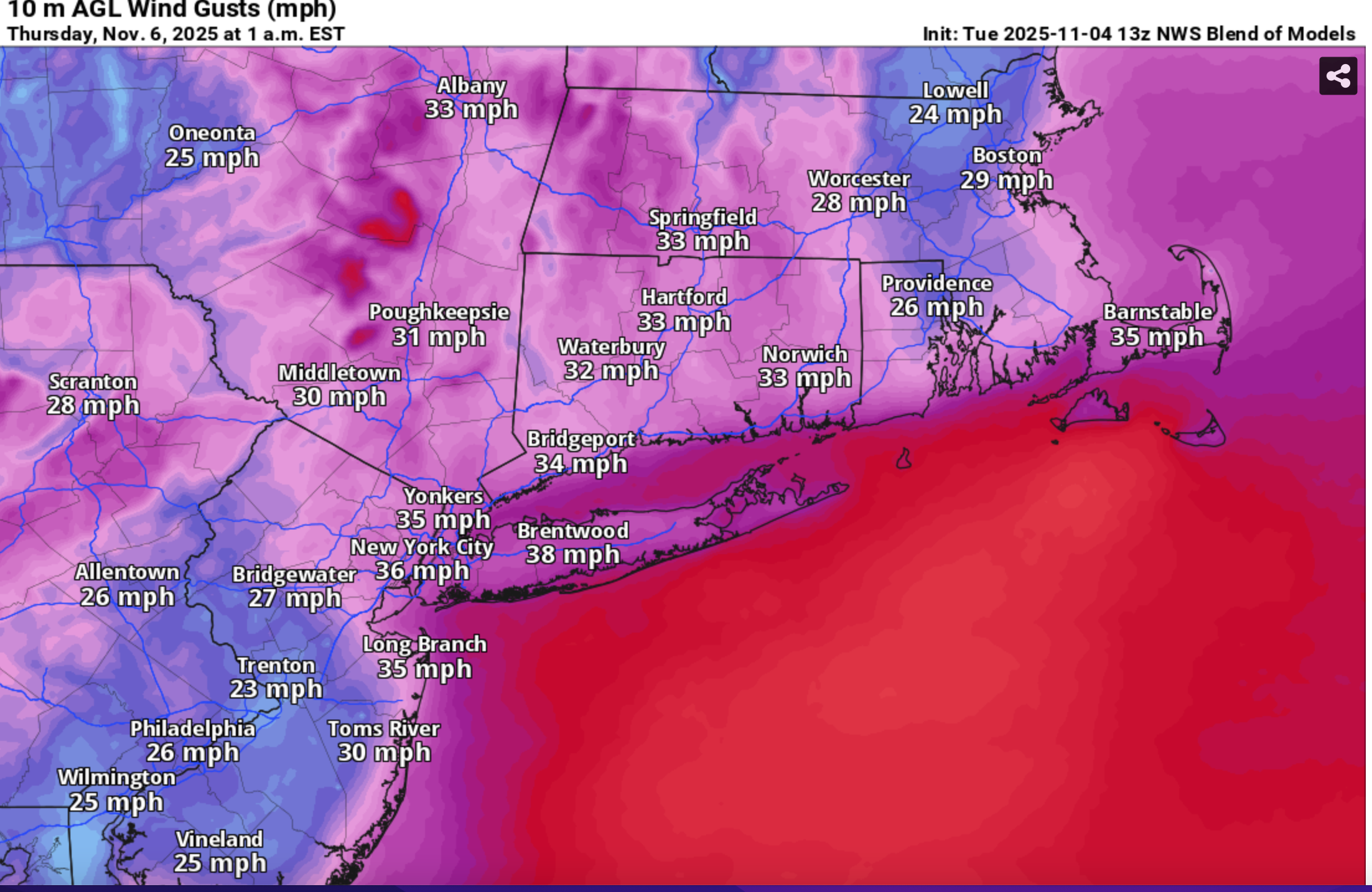
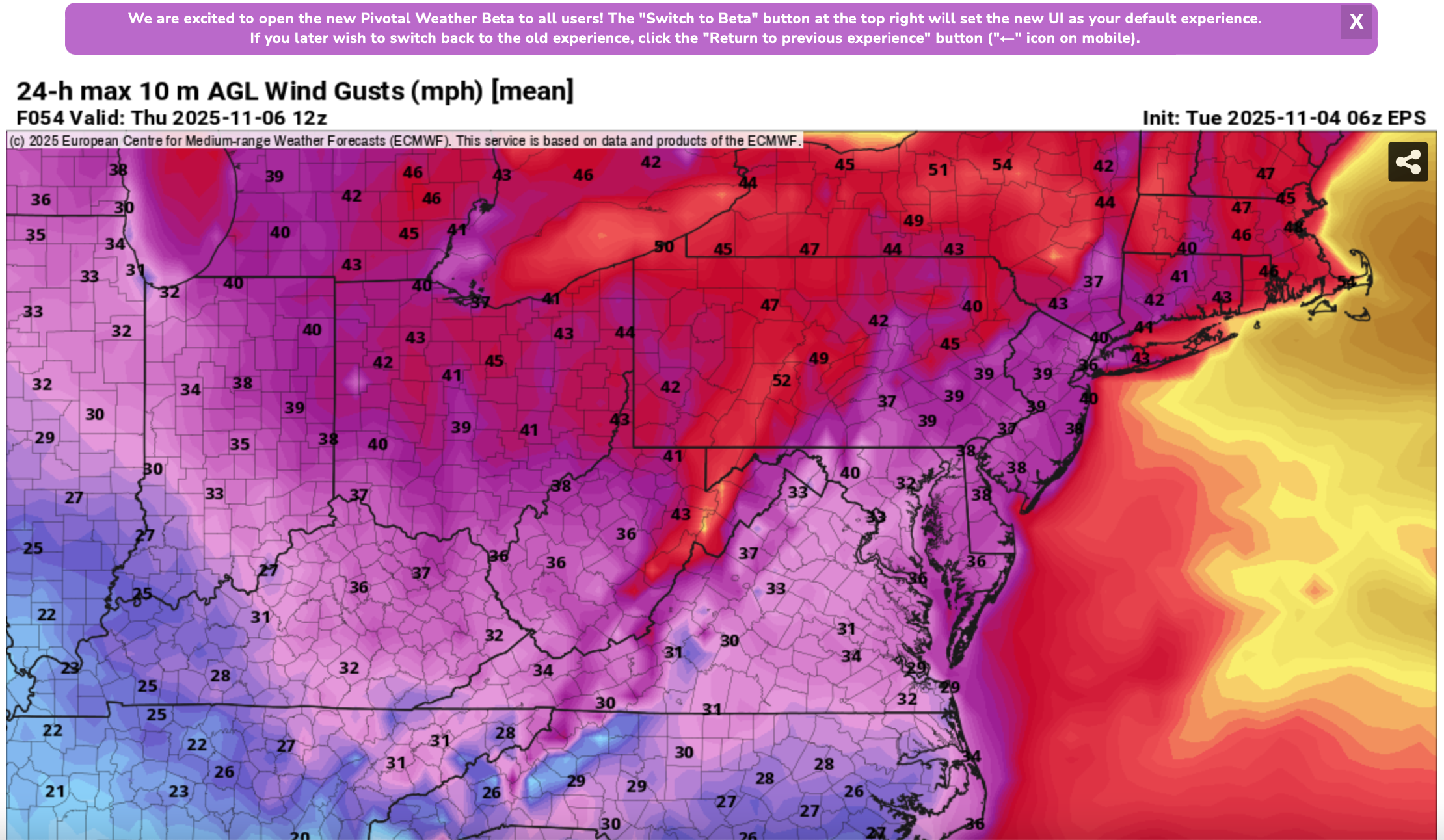
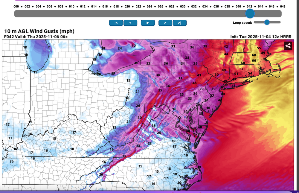
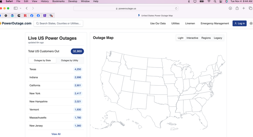
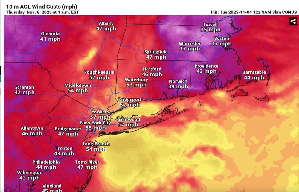
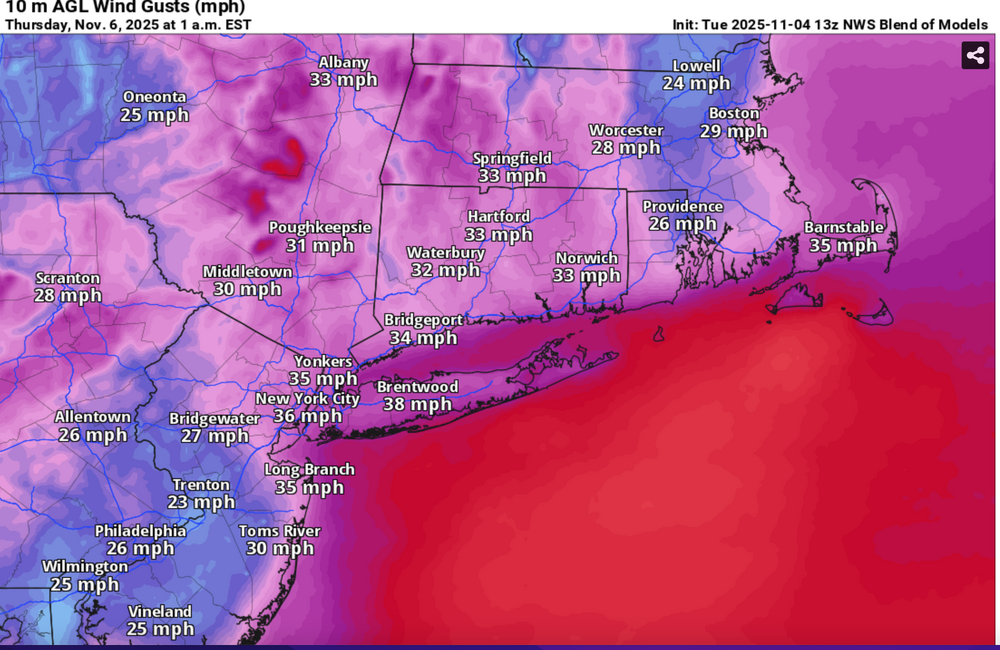
Please follow whatever NWS OKX PHI ALY and BOX issues on the coming Wednesday night wind and tides. From our subforum standpoint have tagged wind damage for Wednesday night's brief but significant wind event associated with a 55-65KT 850 MB Cold Air Advection jet overhead. No guarantees, so the worst case 12z/4 HRRR and NAM suite max wind gusts should be 5 MPH too high but nevertheless, we should see more power outages than this morning (attached), and I expect at least a few night time -Thursday morning detours travel delays due to downed tree branches especially ridges and through NYS-CT. This will impact air travel for arrival departures Wednesday evening possibly into Thursday morning. Lapse rates look unstable for a few hours Wednesday evening up to at least 900MB, with strong subsidence drying in the wake of the Wednesday evening cold frontal passage adding to momentum transfer. A 12 hour 500MB HFC of over 150M amplifies in its east-southeast trek across NYS into New England Wednesday evening, briefly increasing the nw 850MB jet behind it to 65 kt or a bit higher. PA/NJ look to be on the southern fringe of the greatest impact which should be NYS and New England. It's an early call so no guarantees but I think its worth an eventual wind Watch or Advisory. I expect at least half the airports in the NYC metro area to hit at least 40 kt, possibly reaching 50 KT? Wind gust potential diminishes rapidly in our NYC subforum area by dawn Thursday. BLOWOUT Tide Thursday morning?: There is a chance that parts of the east facing coasts at just after midnight Thursday morning's LOW tide cycle will see a blow out tide less than -1.6' MLLW because of this brief period of wnw wind. Added HRRR max gusts at 10P/5 and 1A/6, the 12z/4 FOUS with my own personal trigger of 27KT BL wind as a threshold of wind event concerns, the 844AM today power outages with the relatively light sub 40KT gusts. Then I added the 3K NAM sampler max wind gusts, the more conservative Blend Of Models wind gust forecast and the the EPS marginal advisory wind gust modeled prediction. 1058A/4


- 68 replies
-
- 5
-

-

-
- wind damage
- power outages
- (and 1 more)
-
Follow and. further NWS updated advisory statements and possible police detours. Now that yesterdays has passed, backside wind gusts will be increasing to 40 MPH throughout the area this afternoon, with scattered or isolated gusts to 50 MPH breaking a few tree limbs and even causing rain softened ground to permit fully leaved trees to possibly topple. This would be life threatening to those unfortunately in the path of limbs breaking. Be aware of possible detours and delays this afternoon-evening. Air travel continues to be impacted, especially Noon to near midnight with certainly delays, and probably some cancels. Using the 00z/31 EPS max wind gust tool, max gusts are anticipated to be 45-50 MPH with the SPC HREF Fire MINIMUM wind gust tool offering at a minimum, near 40MPH gusts on land, except 50 MPH one the ridges and of course on the water. I do not have access to other sounding wind gust tools. 714A/31
-
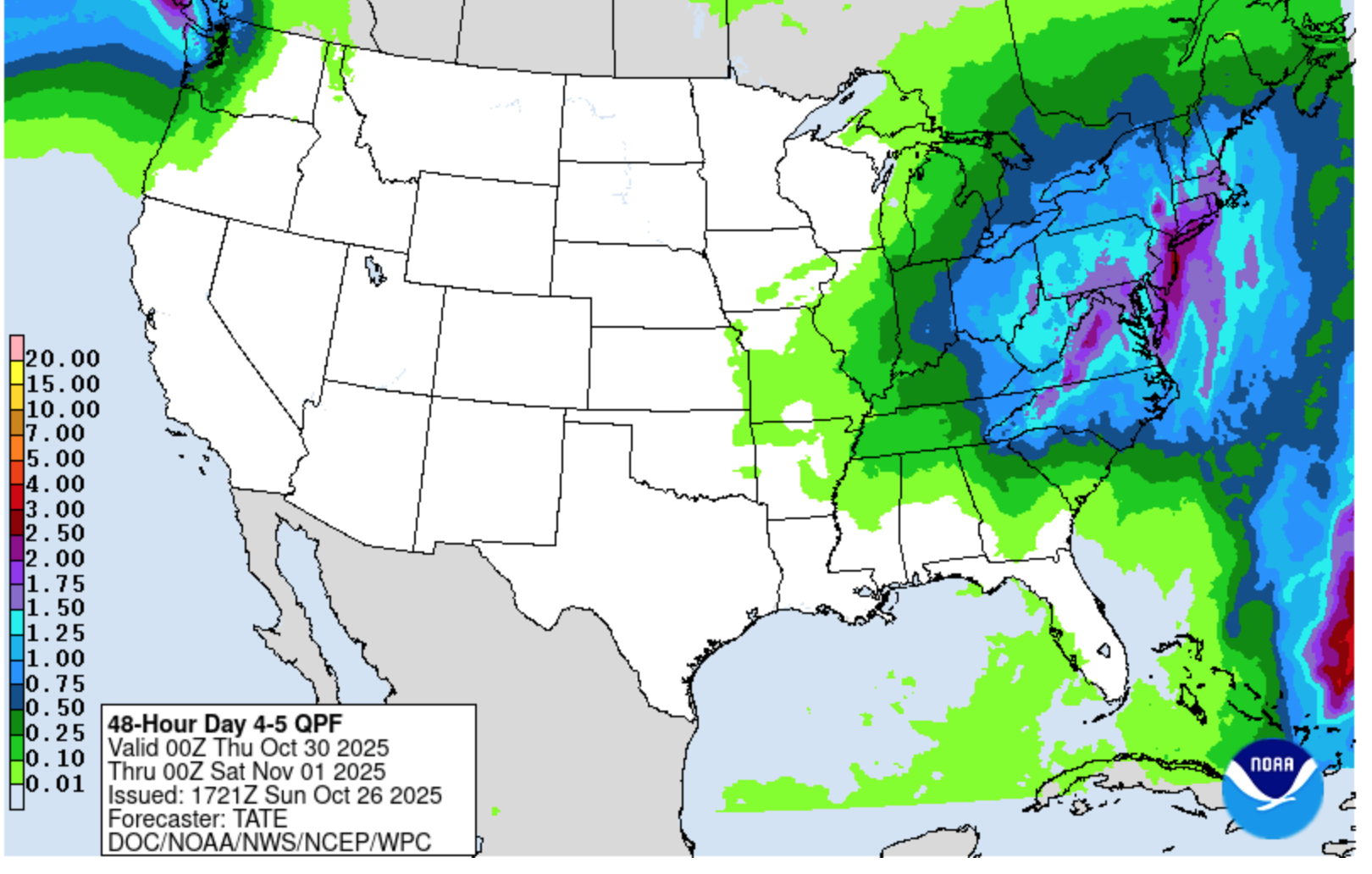
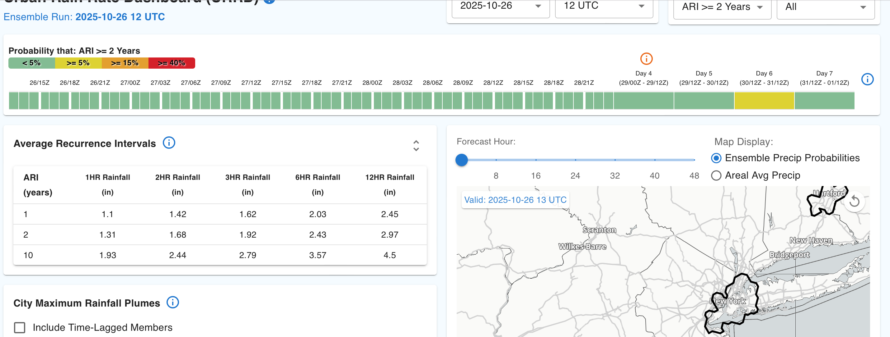
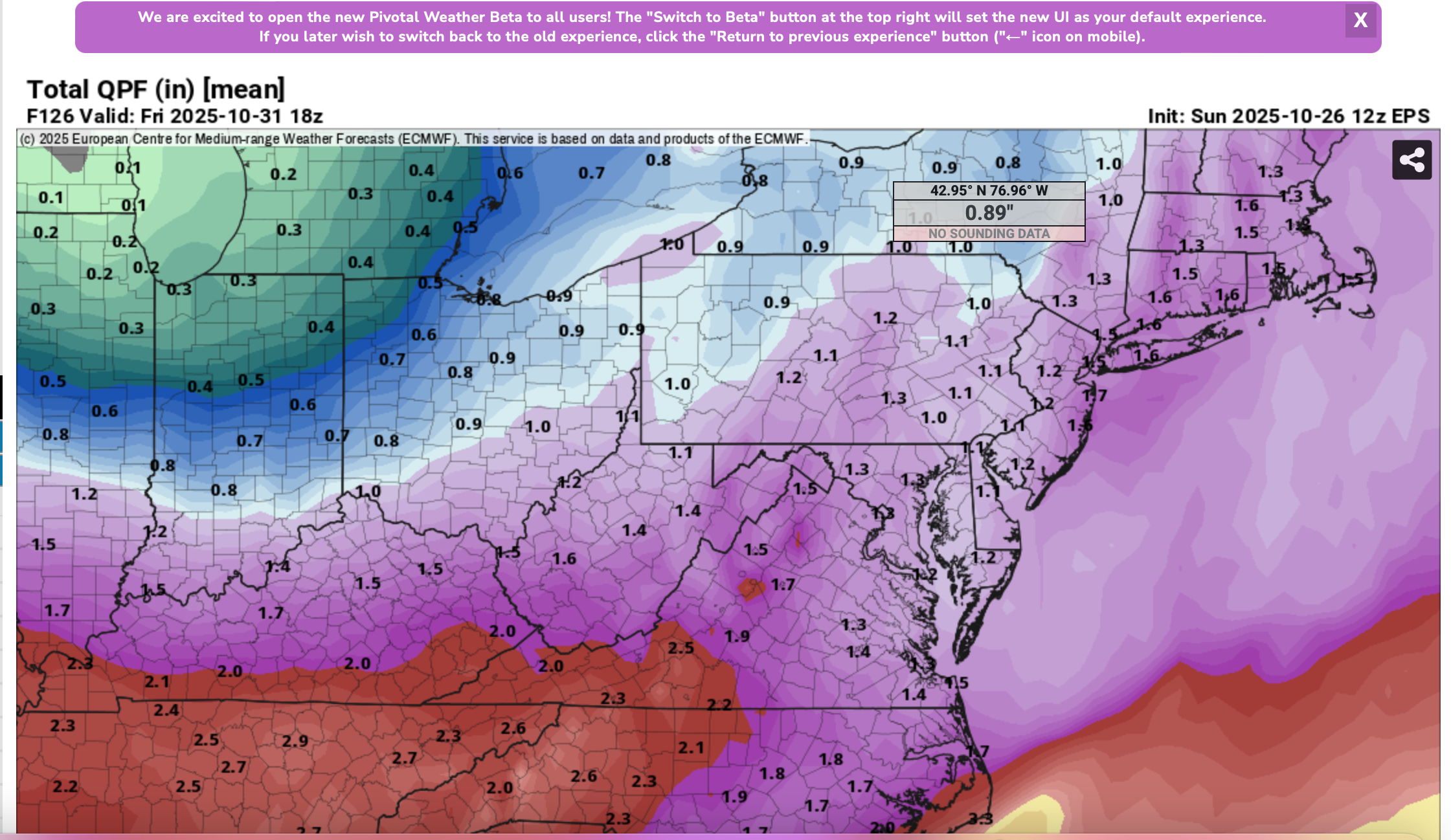
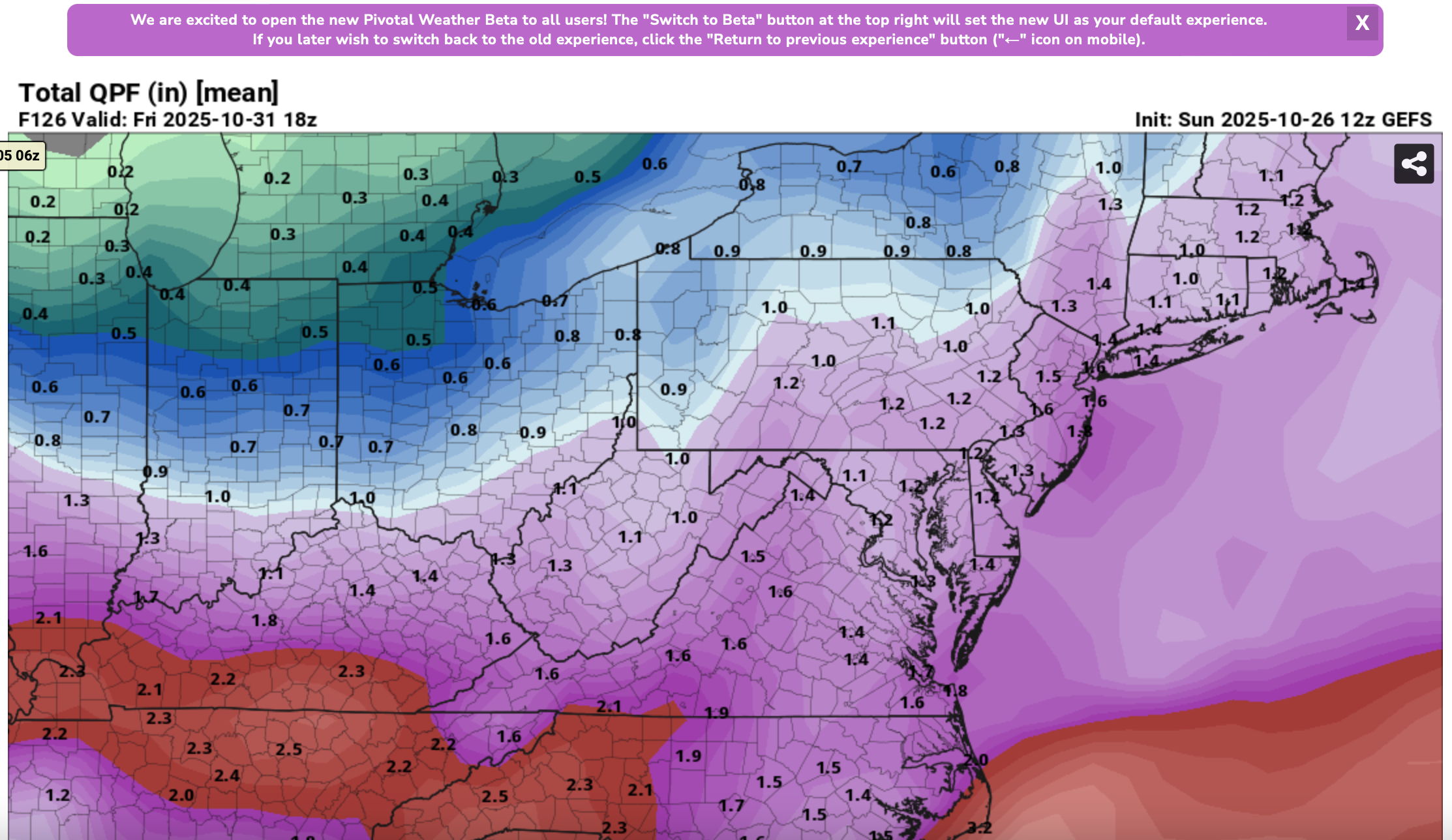
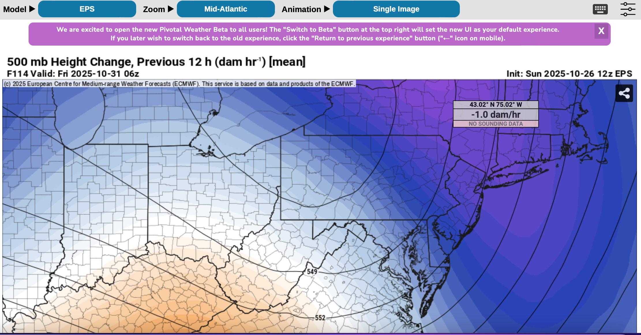
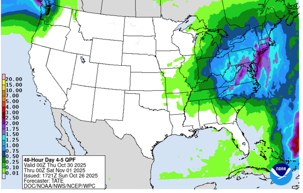
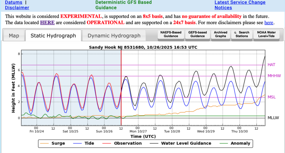
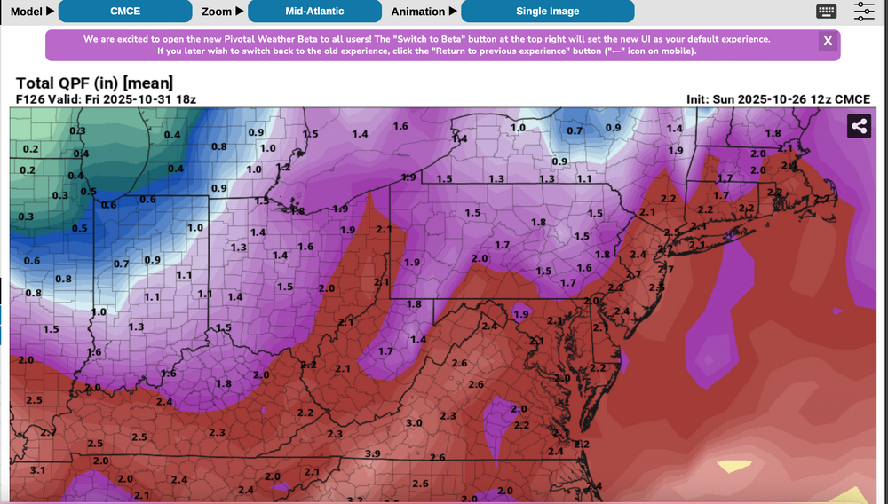
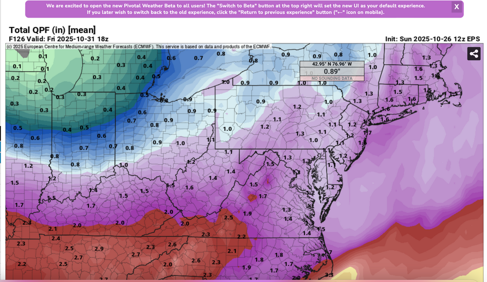
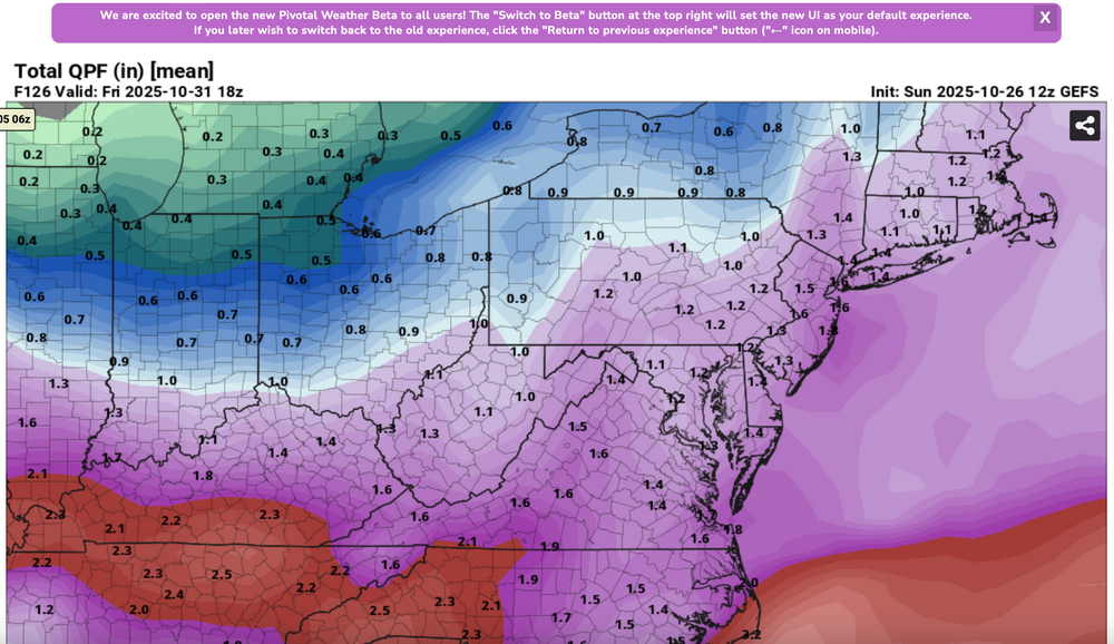
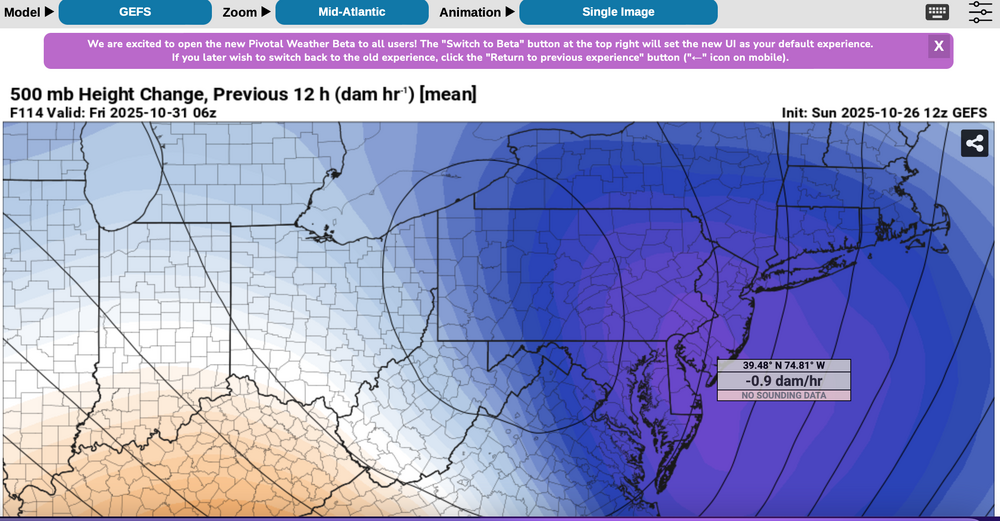
Please follow any NWS Watches, warnings, statements that may arise from this coming minor or moderate event. This is a D4-5 advance heads-up thread for those who have a need to be advised. Modeling has plenty of spread in solutions so that the ensembles are somewhat muted. There is no doubt in my mind that some sort of minor or possibly moderate impact event is coming. Modeling has been wavering for the past 4 days and hopefully uncertainties resolve by mid week. If I had plans as a motorist or via air travel Thursday-early Friday, I'd think about delays and how to minimize adverse impact, then possibly implement changes Tuesday or Wednesday Timing of the 6-10 hour worst case is uncertain. Beneficial rainfall should result in October totals at all NWS OKX-Upton climate sites roughly 3.3-4.3", within about 1/2" of normal. Not everyone will get 1"+ but the attached Sunday afternoon 10/26 WPC guidance is a best estimate for D4-5. Rainfall still could end up less than indicated. A graphic of average return interval (ARI) for various event amounts, at NYC, is attached-not alarming. This could still end up a routine event although I think wind can add impact. Rainfall intensity during one of the rush hours combined with potential for a period of east-southeast wind gusts 45-55 mph on the remaining wet fully leaved trees may result in a scattering of broken limb caused power outages, similar to the 10/12-13 event. Lunar cycle argues for maximum worst case coastal flooding in the minor category. Modeling from P-Surge is attached. It might be too robust (follow NWS), suggesting a worst cause 3 ft surge along parts of the coasts during the Thursday afternoon-evening high tide cycle (using Sandy Hook as example). Lowered pressure this time compared to 10/12-13 contributes to the surge. Please be aware ensembles are not showing much more than 50-55knot se inflow here, limiting potential for excessive rainfall and surge. There is a slightest chance for isolated severe however CAPE seems to be very limited, despite the favorable strong shear and diffluent upper level flow. A 100-150M 12 hour 500 MB Height Fall Center circles northeastward from the southeast central USA into PA/NJ early Friday. That helps drive the relatively short duration heavy rain event. Presuming the upper Low continues to evolve northward through PA into NYS the eastern Great Lakes there should be a progressive rapid improvement sometime Friday morning. Westerly winds may gust 25-35 MPH at times during Halloween evening but hopefully without any showers in the area. Ensemble rainfall from several modeling centers has been attached as something to look back upon Saturday 11/1 when all the totals are in. The 500MB ensembles attached also show the 12 hr HFC. Fairly modest in comparison to some of the operational cycles we've been seeing the past several days. If the 5h ensemble pattern prevails or is further west, then we've tracked a routine event. The thread current headline will eventually update if moderate impact potential decreases. For now this hopefully adequately summarizes what is on the table for rain/wind/coastal concerns. Let's see if its worth tracking. 620P/26


- 246 replies
-
- 12
-
-
-
- heavy rain
- damaging wind? squalls?
- (and 2 more)
-
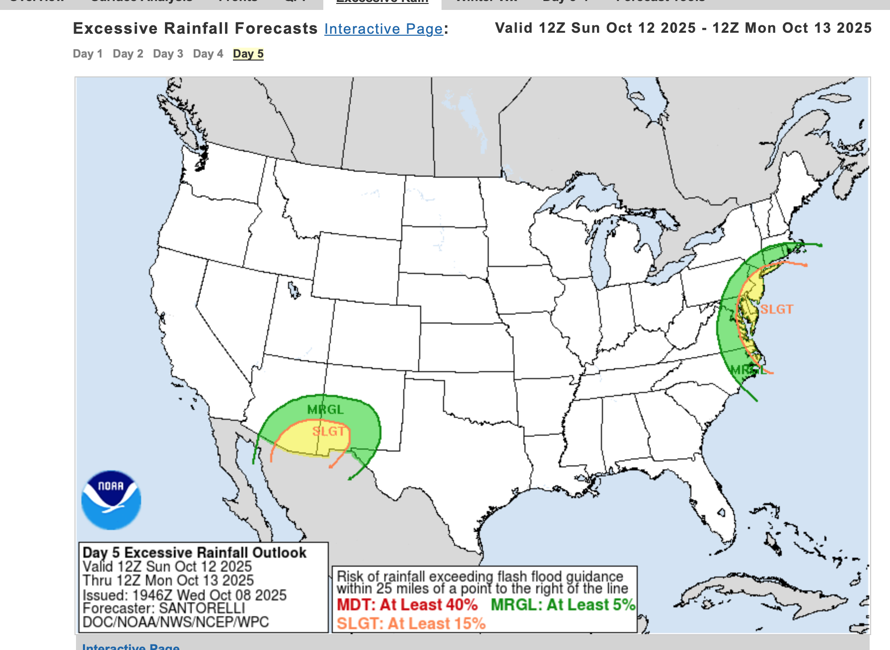
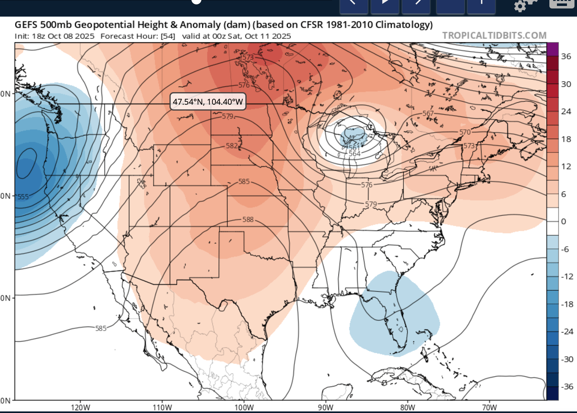
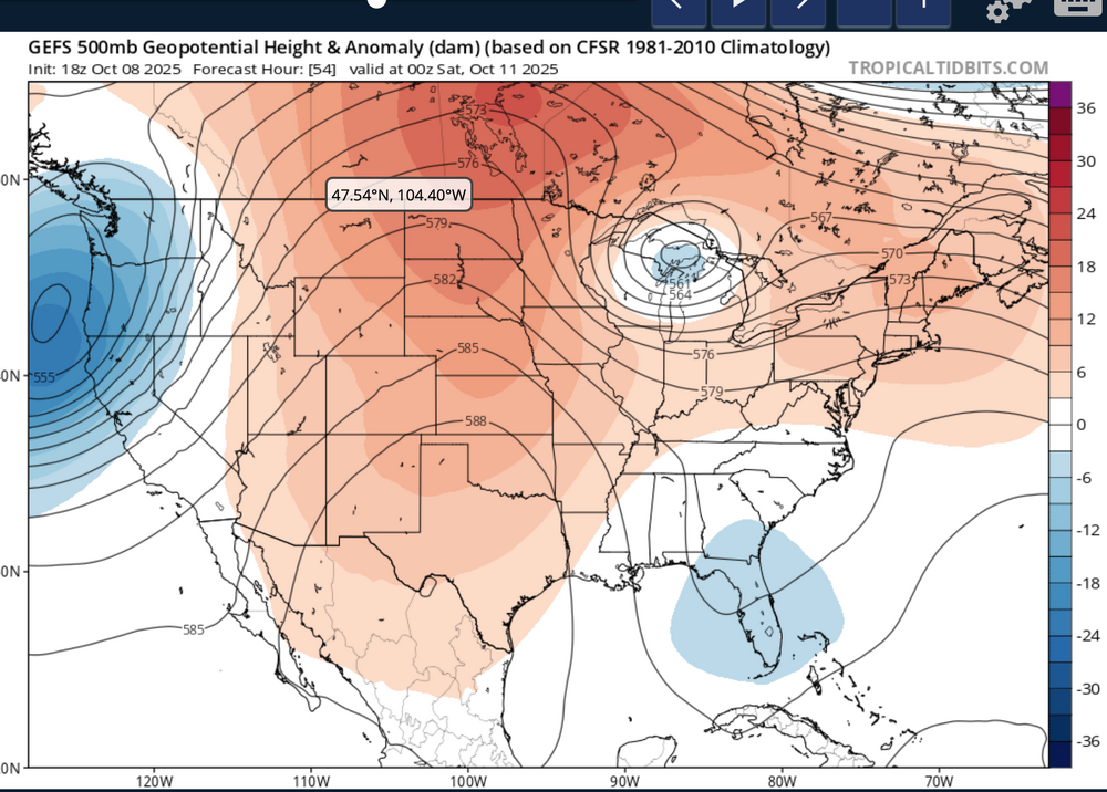
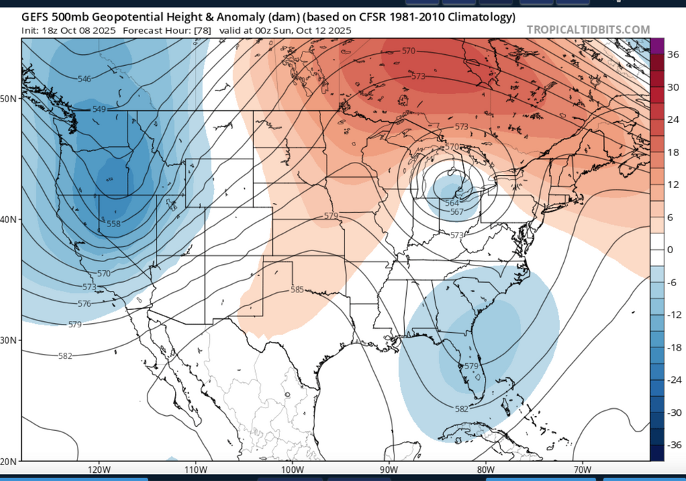
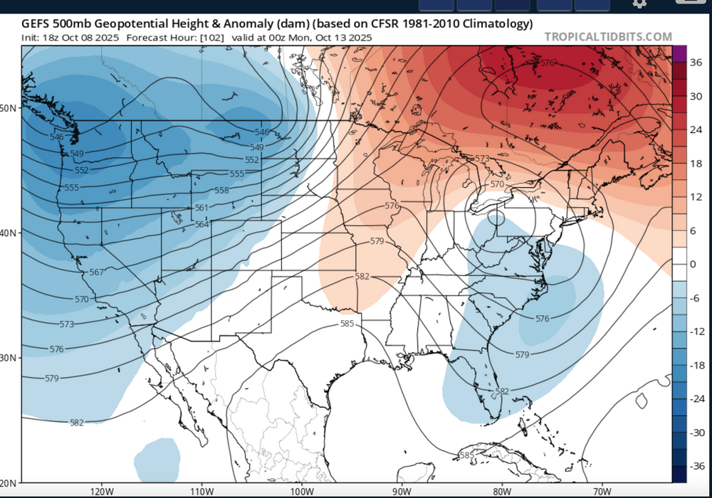
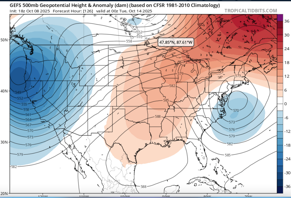
Nor'easter coming Sunday-Monday though track uncertain ranging from coastal hugger e of NJ worst case scenario to further southeast and less impact. Graphics added are the Wednesday afternoon's WPC 5 day rainfall forecast ending 00z Tue 10/14, The WPC D5 concerns for excessive rainfall issued this Wednesday afternoon - Isolated 4" in the slight risk area but general 1-2" foreseen for much of the NYC subforum between 6AM EDT Sunday and 6AM Tuesday. Also added 4 successive 24 hr forecasts of the evolving 18z/8 GEFS 5H field which I hope repeats this winter... a phaser with a southeastward diving cold core strong short wave through the Great Lakes this weekend that ingests-draws northward - the moist trough currently developing along the se USA coast and results in a fairly intense storm along the mid Atlantic coast by Sunday. The EC EPS 24 hr max wind gust tool has been cyclically consistently offering 60+ MPH in the western Atlantic and 50+ MPH along parts of the NJ-LI coasts. If this occurs, in conjunction with heavy rainfall, fully leaved tree branches would break or even uproot in some locations. No guarantees on wind strength at this time The strong chilly high pressure system that is developing into our area now will become part of a eastern Canada block and set up a strong easterly gradient over our area and should result in multiple cycles of at least minor coastal flooding with a pretty strong potential for at least one high tide cycle moderate coastal flooding (even outlier LOW PROB spotty major) for either the midday Sunday or midday Monday high tide cycle along the NJ coast. Full moon is past us so the astronomical higher tide cycles are lowering and helps reduce the chance of more than moderate coastal flooding. Still this is 4-5 days away, so intensity, track and system evolution are not locked into a worst case scenario and will ultimately determine impacts. Erosion will occur...severity unknown. It appears the ECAI has been most cyclically stable predicting this storm for our NYC subforum dating back to I think the 00z/4 cycle. Did not look at standard deviations departures of the 850 MB inflow but suffice to say, its stronger that normal. PWAT generally near 1.5" minimizes potential for much greater than 4" though the 2" PWAT axis lies just offshore. Thread headline Original thread headline below, adjusted 422 PM Saturday 10/11 "Potentially" powerful Nor'easter Sun-Mon 10/12-13/25 with needed rain-especially south of I84, and fairly high impact sct coastal gusts 50+ MPH and possibly moderate or greater coastal flooding at the midday Sun and Monday high tide cycles. posted 741PM/8

- 731 replies
-
- 9
-
-
-
- heavy rain
- damaging wind
- (and 2 more)
-
Periods of rain, some of it heavy at times is destined for most of the NYC subforum Friday-Saturday as low pressure develops off the mid Atlantic coast into a vertically deep slow moving cyclone. PW increases at times to near 1.7" in warm advection along the inverted trough Friday then the pinwheeling PWAT circles back around our area Saturday. Gusty northeast-east winds Friday morning to 35 MPH and the constancy of northeast flow this week at the time of the highest tides in Sept should yield at least minor coastal Flooding within 2 hours of high tides Friday and possibly moderate coastal flooding at the highest tide cycle Saturday or Sunday as the backwash of the offshore storm shoots some 45 MPH north-northeast winds down the NJ coast by Sunday morning. The previous 3-4 day rains are attached, and the numbers for this coming one may exceed 6" again in parts of the NYC subforum. If so, where? It's possible, despite all this projected rain, that flooding might be imited to a few small areas. Too early to be sure as of 447PM/27. The EPS has been most aggressive with this system since 9/24 cycles and the 12z/27 EPS mean rainfall is attached. These values are quite high and much higher than the GEFS 12z/27 cycle with the GEPS midway between. If it causes fresh water flooding---where? Not sure this will be very much freshwater flooding except possibly NJ/CT/urban LI. This topic should serve also for the rainfall reports. at 505PM added the tag power outages. If this rainfall develops per the more aggressive 12z/27 EPS mean, rain softened ground from this past weekend combined with new 2+" rainfall may allow spotty power outages due to tree uproots of still fully leaved trees.
- 886 replies
-
- 3
-
-
- heavy rain
- flooding potential
- (and 2 more)
-
Monitor NWS products including NHC and local offices from OKX and PHI. This Topic doesn't guarantee anything but serves as a platform for comment. Suggest starting with actual 5+" rainfalls, or unusual flooding. Note: WPC is already bullish on Tuesday's rainfall. Tropical Debby remnants-east coast trough-RRQ upper level jet related pattern this week had WPC intermittently forecasting 7+" of rain in NJ and possibly coastal CT/LI. PA and se NYS may also be involved in big rain. PRE conditions may??? exist late this week (Fri-Sat?) but uncertain in our NYC subforum. Added a few graphics. WPC overall has been advertising 5+ in its graphics for our area since 06z/4. Below is the WPC 7 day rainfall forecast based on ensembles etc. Sampler past 3 days rainfall via CoCoRaHs. Machine ECMWF EFI, Machine GEFS ARI and UFHS, WPC D2 excessive and their D5. You'll note the GEFS machine tools extend beyond D5. This weeklong accumulative event may be over by Sunday the 11th. FFG is very dry south of I80, so far. This could. change radically by Friday night. Ensemble river stage products right now are conservative but highlight I95 corridor in our area. FFG for now is most vulnerable I80 northward in NJ. What to do? Just think of what you may??? need to alter in your plans due to flooded roads/streams, cellars. Potential doesn't mean it occurs. 727A/5 Initial title Potential POCKETS 5-12" of rain by 18z Sunday. Suggest OBS Tue-Sunday only when exceeding 5".123411
- 527 replies
-
- 2
-
-
- flash flooding
- river flooding
- (and 2 more)
-
This first event is slated mainly for Monday night-early Tuesday night but with a pulse of showers, some heavy occurring overnight Sunday night and potential for bands of high wind and or heavy rain remaining in the NYC subforum into early Wednesday, depending on the departure of the eventual nor'easter. Max gust for e LI may get close to 70 MPH with wind damage 'potential' of 50 MPH gusts s of I84 in CT into far se NYS through ne NJ. Fully leaved tree branches with potential for sodden ground uproots Tuesday due to heavy rainfall and the gusts should result in pockets of power outages from simply broken branches. If it looks extensive, we will update the topic title. Max rainfall seems to be targeting CT/se NYS/NYC metro-ne NJ but proximity of max inflow-moisture transport still showing modeling variability for the primary target. In any case... it appears likely that along and north of I78 there will be periodic showers overnight with new rainfall by sunrise ranging from a few hundredths to possibly 1". After a break Monday, bands of heavy showers should be developing north and northwest into the area Monday evening and slow their northwest to west progress Tuesday before turning southward later Tuesday night. By 8AM Wed, isolated 6" rains may have occurred with a general 1.5-3" in the subforum. FF potential while initially limited by recent dryness, the rainfall rates and amounts in banding will eventually determine where any FF potential will be realized-it's just too early to determine, as of this 720PM Sunday writing. Please follow all future NWS warnings/statements. Let's see what the OBS herein tell us about the modeling by Tuesday night. Edited title rainfall up from 1.5-4 iso 6, to 2-5, iso 8. Edited title at 1025A/26 to like 40-60KT gust focused on CT-LI.
- 228 replies
-
- 4
-
-
- heavy rain
- flash flooding
- (and 2 more)