

brooklynwx99
-
Posts
4,599 -
Joined
-
Last visited
Content Type
Profiles
Blogs
Forums
American Weather
Media Demo
Store
Gallery
Posts posted by brooklynwx99
-
-
1 minute ago, psuhoffman said:
@brooklynwx99 I was saying a lot of the same things you are years ago when people were alarmed. Nothing you’re saying is wrong when taken in a vacuum. But it’s been warm with very little snow for a long time now. If it doesn’t snow soon those statements just start to wear thin. It’s not you.
trust me, I get what you're saying... I just think we need to give this another several years to really make legit conclusions on it. the sample size is just too low, especially for commenting on the efficacy of Ninos at large. we just don't have enough data
-
 2
2
-
-
Just now, CAPE said:
Once in a blue moon, and mostly because of a KU and a few nickel and dimers. But I am afraid that Ninos have largely become impotent.

Still have to test the Modoki with blocking, if that is even possible anymore. If we get that, and it fails, well, you know.
I think this is recency bias. 2016 produced one of the biggest HECS in history and 2018-19 was literally weak sauce from the get-go
-
my point is that all of this broad scale stuff about the state of winters to come for the next decade or whatever shouldn't be looked at as anything more than pure speculation. the declarative statements are a bit grating
-
4
-
-
1 minute ago, psuhoffman said:
I feel like I’m looking at the scoreboard and we’re losing by 50 at the 2 min warning and the coach is saying “it’s ok guys, everything’s fine, focus on the next play”.
lol that is the nature of the weather, dude. nobody really knows what's going to happen. also doesn't help that the two legit Ninos that we had were either the strongest ever or still super. one of them produced the largest EC storm in 30 years
-
2
-
-
8 minutes ago, psuhoffman said:
OK then...explain to me the longwave configuration that would work with that above? You realize the pac is actually GOOD there and the trough is over us...but none of that matters if its F'ing hot EVERYWEHERE
lol dude it is a smoothed +2 meter anomaly. come on
-
1
-
-
8 minutes ago, the_other_guy said:
40 degree back to back winters with plenty of precip.
There’s absolutely no comparison whatsoever to the 60s or 70s or 80s. that’s just trying to gloss over and compromise with reality
We lost the snow because it’s too warm.
yeah, there definitely is no comparison. there is a much higher frequency of larger storms than there ever was in those decades. LI was also a lot less snowy. unless you guys want nickel and dime winters with 10-20" of snow
-
5 minutes ago, LongBeachSurfFreak said:
What I would really like to see before we pass the tipping point is an area wide 30”+ mega storm. What we really need is a reshuffle to get us back to a more -epo pattern again. Hopefully this will El Niño reshuffled the deck.
A super high ACE season looks like a lock, which often precedes a good winter. We don’t need much to beat the last 3.the Jan 2018 bomb cyclone could have done it if it was just closer to the coast. was a triple phaser like 250 miles offshore and still brought major snow
-
1
-
-
1 minute ago, Brian5671 said:
Brutal....
yeah we've dealt with worse. this is a crappy stretch, don't get me wrong, but we also just had 2020-21 and likely have some more winters that break that 30" mark in the future soon enough
-
i think people are forgetting that there have been similarly lame stretches. yes, we don't get the 10-20" years as much, but who cares
KNYC had one winter with over 30" from 1969-70 through 1993-94. one! that is an absolutely dry stretch. we have had 13 such winters since 2000
-
 1
1
-
-
1 hour ago, snowman19 said:
Guess the early March SSW is going to go down in flames….again. Doesn’t look like it’s going to downwell into the lower stratosphere and couple with the troposphere. Surprise, surprise….another hyped fail incoming. Time to declare this winter dead
probably best to let things play out. wouldn’t be surprising to see a -NAO form from a retrograding Scandi high around the 10-15th or so. it’s been showing up on ensembles
not saying it’s going to produce winter weather, but there’s no real point in ruling it out totally at this range
-
2
-
-
really would not be shocking to see a Scandi ridge -NAO pop up around the 10-15th or so. if it produces winter weather is to be seen, but it’s something
-
4
-
 1
1
-
-
7 minutes ago, snowman19 said:
Lol @the_other_guy Apparently a freak mesoscale, narrow band means all the February hype verified!!
i never said it verified. it busted pretty bad. but to say that the can has been kicked the whole winter is quite disingenuous
some saw two significant events in a week… the immediate NYC area isn’t representative of the whole metro region
-
4
-
-
4 minutes ago, snowman19 said:
Yep. Now it’s “mid-March onwards”. How many times is this now? Just keep kicking the can down the road….
some places in central NJ got 20” of snow in a week. stop it lmao
-
5
-
3
-
-
2 minutes ago, Brian5671 said:
Not much cold air around (snow/ice cover lacking nationwide) and by mid march normals are in the 50's...
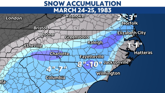
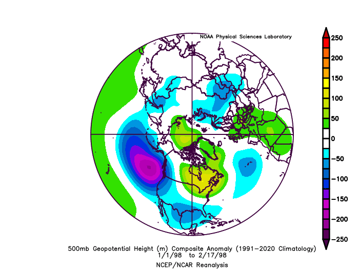
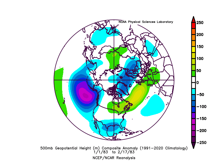
yeah, it'll be an uphill battle to get snow, but it's happened before. 1998 and 1983 both had abnormal snowfalls... 1983 had this in the southeast during the last week of March
-
4
-
-
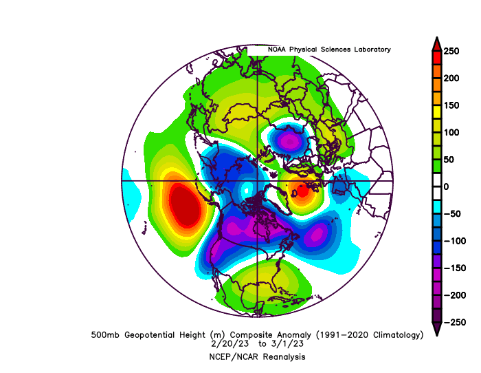
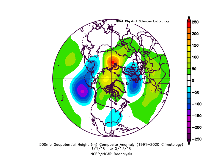
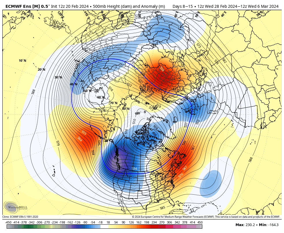
you can see the resemblance to the patterns before the 2018 and 2023 blocking events. pretty similar stuff
.webp.81aa892757a149d2a8d34f090395fedd.webp)

-
5
-
 1
1
-
-
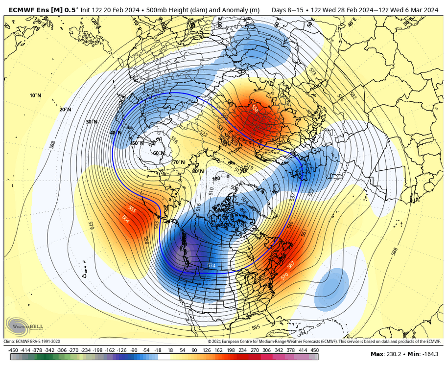
wouldn't shock me to see blocking return in some fashion in mid-late March. a brief reversal of 10mb winds already occurred, and another is expected to occur during the first week of March. the upcoming 500mb pattern fits that of the 2018 and 2023 blocking events quite well, which were also from SSWs. not sure if it means any more winter weather, but it's something to note
.webp.0a5d79160fb19a11f3739fc571ae2f6b.webp)

-
1
-
 1
1
-
-
3 minutes ago, Stormlover74 said:
Here we go again lol
it wouldn't shock me to see blocking return in mid to late March. whether that means winter weather or not is a different story, but it wouldn't be surprising at all IMO
-
4
-
2
-
-
36 minutes ago, EastonSN+ said:
I know it's not completely over, however it's not look great for more snowfall.
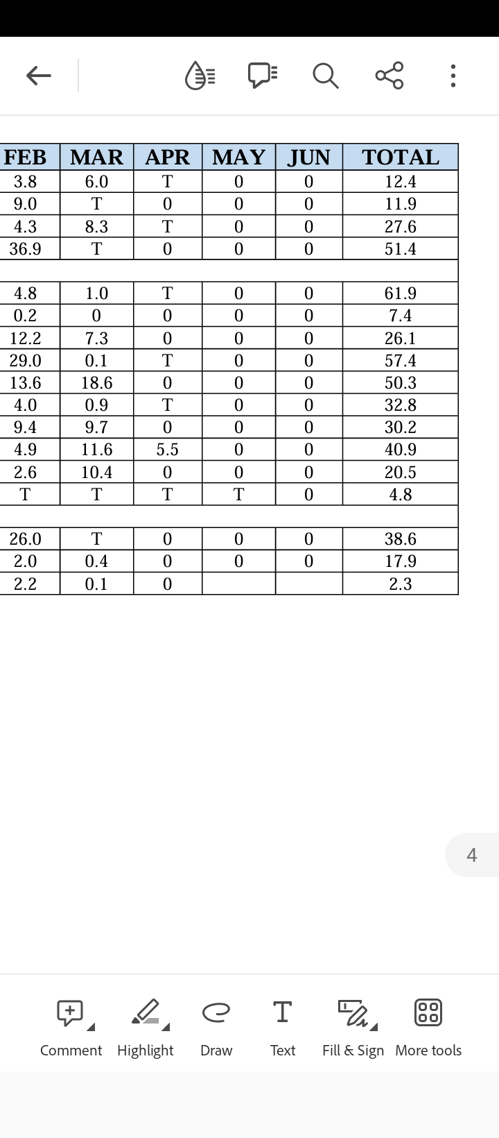
That would put this decade at 3 below average snowfall winters, only better than last years total. Average this decade before this winter was 19.6 and will take a hit when this year is ultimately added.
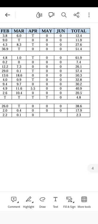
look at the decade before with the 33.2" average and you can see why we likely regress to under the ~29" 30-year average this decade
-
1
-
-
hell, even that favorable pattern in mid-Jan looked like a good Nina configuration. AK ridge with no Aleutian low to be found. along with the historic cold outbreak in the Rockies and Plains. so odd

-
4 minutes ago, 40/70 Benchmark said:
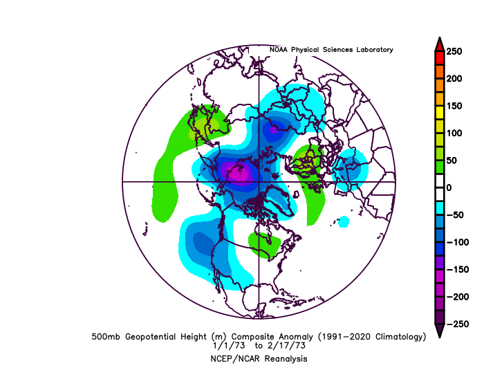
1973 is a pretty good match. I liked that analog with respect to everthing but the polar domain, which has worked out. I just wish that I hadn't factored the polar fields so heavily into my snowfall totals because as it turned out it didn't matter.
1973 was definitely the best match out of those winters, especially given the -PDO. even then, there's still barely any low pressure signature where there should be one. would have made a difference if the blocking had worked out, but it makes sense that we would see one of the biggest medium to long range pattern collapses in recent memory
-
15 minutes ago, 40/70 Benchmark said:
Yea, the issue wasn't El Nino...had nothing to do with that. The issue was the same one that has been plauging our winters for several years now independent of ENSO and that is an unsavory extra tropical Pacific. But its a fruitless endeavor to logic with the butt-hurt types that swore up and down that winter would suck because of the strong El Nino, as a preemptive defense....now that winter has in fact sucked, they want their validation in lieu of winter and good luck depriving them of that-
lol the Aleutian / Gulf of AK low is non-existent. absolutely infuriating. just not even close to the others, even the ones that did torch


-
1
-
-
1 minute ago, Terpeast said:
Could the marine heat wave off Japan have anything to do with this?
If it’s not MJO4, if it’s not EAMT, then what…?
PDO definitely has something to do with it, just thought the Nino would be a bigger factor in forcing a +PNA
-
1
-
-
all of the other super Ninos had at least some kind of persistent low pressure in the GoA or nearby. seems like 1973 was the best fit, but this year still has much less of a signature there


-
1
-
-
hell, even the great pattern that developed in mid-Jan looked like a blocky Nina pattern. there was a historic cold outbreak in the Rockies, which is not supposed to happen in these borderline super Ninos. something is off
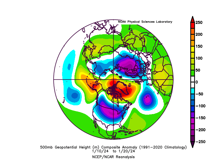
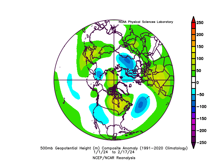
this might look like a super Nino on the DJF temp aggregate, but it's like getting a multiple choice answer right without showing work. Dec is the only stretch that behaved like it should have. like where the hell is the low in the GoAK or Aleutians at all? it just doesn't exist on the mean
-
3
-

Late Feb/March Medium/Long Range Discussion
in Mid Atlantic
Posted
IMO, there are only two things that CC has done that are pretty much indisputable:
that's about it. anything else is speculative at best