baroclinic_instability
-
Posts
7,869 -
Joined
-
Last visited
Content Type
Profiles
Blogs
Forums
American Weather
Media Demo
Store
Gallery
Everything posted by baroclinic_instability
-
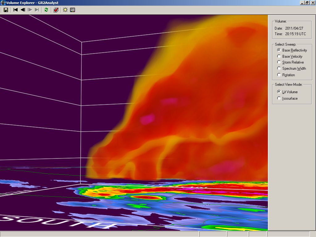
 Wow--another great closeup vid. This tornado will likely have a lot more vids showing up in the coming days as folks upload and share them.
 -
That is great information to have. That type of stuff saves lives--and being prepared like that is something great to see. I loved how they posted continuous updates through the day as things were ongoing.
-
Great to see this. University of Alabama at Tuscaloosa was prepared. Shows how prep can really make a difference. Read from the bottom up. http://www.ua.edu/weather/
-
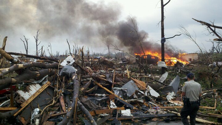
Yeah I agree--the devastation is just absurd.
-
Cmichweather posted this earlier comparing it to Moore. Check this image too:
-
I am no tornado expert and I have yet to have any experience doing surveys, but the damage has to be representative of at least EF4 based on pics, possibly EF5. We will see. Totally stripped trees with no branches, destroyed buildings of decent size, rubble everywhere, etc.
-
It is. I guess I should remember how much CNN sucks anyways--maybe not the best example to use.
-
Shows how pathetic news is here in the US. BBC and and other European news sites have their front page news stories about this event. Here--CNN has the Obama birth certificate/Donald Trump crap as the front page news. What a joke.
-
Wow amazing that made front page news overseas. I am still in awe of this event myself.
-
An MCD I will never forget just as this was getting going. MESOSCALE DISCUSSION 0629 NWS STORM PREDICTION CENTER NORMAN OK 0256 PM CDT WED APR 27 2011 AREAS AFFECTED...MUCH OF MS/AL INTO SOUTHERN TN AND NORTHWEST GA CONCERNING...TORNADO WATCH 232...235... VALID 271956Z - 272200Z THE SEVERE WEATHER THREAT FOR TORNADO WATCH 232...235...CONTINUES. PARTICULARLY DANGEROUS SITUATION /PDS/ TORNADO WATCHES 232/235 CONTINUE UNTIL 00Z/03Z RESPECTIVELY. THIS INCLUDES THE POTENTIAL FOR LONG-TRACK STRONG/PERHAPS VIOLENT TORNADOES INTO THIS EVENING AS A SEVERE WEATHER OUTBREAK ONLY INCREASES IN MAGNITUDE/RISK. AN EXTREMELY DANGEROUS/LIFE-THREATENING SITUATION CONTINUES TO UNFOLD THIS AFTERNOON ACROSS A LARGE PART OF MS/AL...WITH ADJACENT PORTIONS OF TN/NORTHWEST GA ALSO EXPECTED TO BECOME A CONCERN LATE THIS AFTERNOON/EVENING. CURRENT OBSERVATIONAL TRENDS...REASONABLY SUPPORTED BY EXPERIMENTAL HRRR GUIDANCE...IMPLY THAT SCATTERED SUPERCELLS WILL CONTINUE TO FORM IN BROKEN NNE-SSW ORIENTED CORRIDORS OF SUBTLE CONFLUENCE AHEAD /EAST/ OF MORE STORMS/SUPERCELLS THAT ARE DEVELOPING ALONG A PRE-COLD FRONTAL TROUGH/DRYLINE GENERALLY NEARING I-55 IN MS. THE WARM SECTOR AIRMASS HAS AGGRESSIVELY DESTABILIZED THIS AFTERNOON AMID NEAR 70F/LOWER 70S F SURFACE DEWPOINTS...REFERENCE SPECIAL 18Z OBSERVED RAOBS FROM JACKSON MS/BIRMINGHAM AL...WITH A WIDE/HIGHLY SHEARED MOIST SECTOR IN PLACE ALONG/SOUTH OF A MODIFYING WEST-EAST OUTFLOW BOUNDARY /NOW AN EFFECTIVE WARM FRONT/ ACROSS FAR NORTHERN PORTIONS OF AL/MS. EXTREME LOW LEVEL SHEAR...VIA LONG/CURVING LOW LEVEL HODOGRAPHS...WILL REMAIN HIGHLY CONDUCIVE FOR SUPERCELLS CAPABLE OF LONG-TRACK STRONG/VIOLENT TORNADOES INTO THIS EVENING AMID 0-1 KM SRH OF 300-500 M2/S2 OR GREATER /ESPECIALLY NEAR THE AFOREMENTIONED NORTHERN MS AND AL BOUNDARY/. ..GUYER.. 04/27/2011
-
I agree. I love meteorology and I am fascinated by it--but an event like this is so sobering. Just think how bad it would have been before the advent of warning systems, etc. I agree a large majority of lives lost were likely folks who couldn't do anything about.
-
The images of destruction are mind blowing and sad. http://www.hamwx.com/?page_id=3969
-
Welcome to the board. It was/is a historic outbreak. I will never forget this one. It reminds me how important the job of a meteorologist truly is. Kudos to the NWS offices, SPC, emergency managers, news outlets, etc for saving countless lives today.
-
Or if you have tornadoes that rip houses off foundations and destroy large buildings...
-
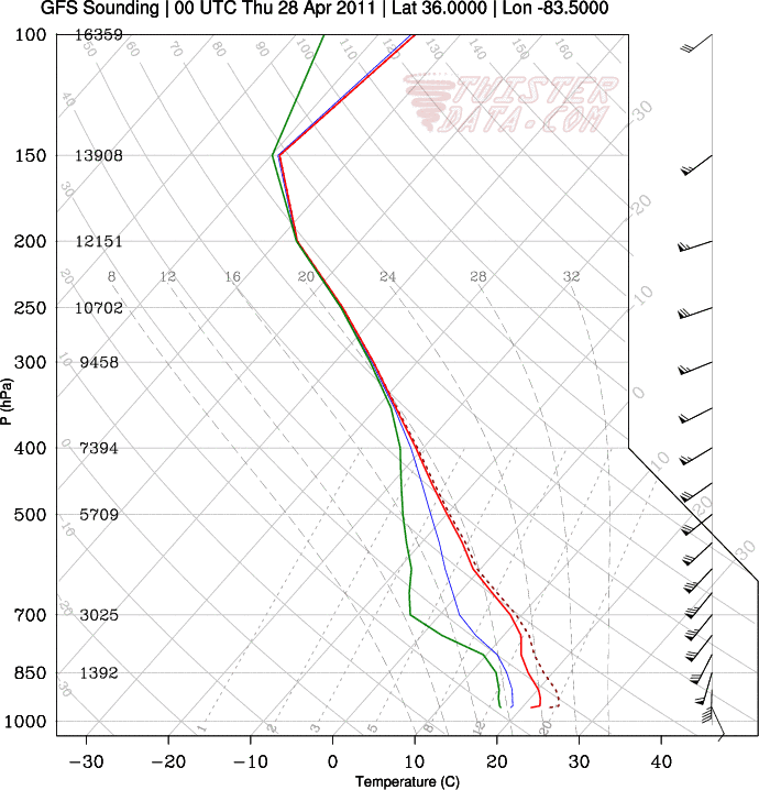
The Birmingham 0Z sounding is still juiced with some outrageous shear/helicity values.
-
Expanded high risk east to include Atlanta.
-
Anymore silly posts from anyone (yes you mongoose) and you will be immediately 5 posted.
-
My gosh. I hope those folks heeded warnings. Just scary stuff here. This is sickening--my stomach is turning watching this unfold.
-
The 18Z special ROAb flight from Jackson is just insanity.
-
you beat me, and that one is better.
-
This storm is hauling quite a stratospheric intrusion. It just looks absolutely disgusting on WV.
-
Good discussion thewxmann, CUmet, Fred, tornadotony, etc. Going to be an interesting forecast for tomorrow no doubt. I don't think large convective cold pools will be a large worry by the afternoon in this flow regime and the strength of the low level theta-e inflow. The bigger questions, imo, seem to be on the synoptic scale flow and the way the models handle the upper pv anomaly and how it ejects north tomorrow afternoon and evening and the associated upper level jet configuration and associated mesoscale circulations/low level mass response (and subsequent hodograph curvature). I wouldn't be surprised if SPC holds on a high until tomorrow when some of the synoptic and subsequent mesoscale forcing details are better known. That said--seems that a high risk will be highly possible over portions of TN and northern AL at some juncture.
-
I don't think the RUC will be right.
-
GFS just bombed this run with the northern stream upper low displaced farther W allowing for more growth of the secondary main impulse Wednesday. Main result is even stronger mid level mass response and a slightly larger occlusion/dry slot, as expected. The hodos are almost unrealistic.