

BoulderWX
-
Posts
632 -
Joined
-
Last visited
Content Type
Profiles
Blogs
Forums
American Weather
Media Demo
Store
Gallery
Posts posted by BoulderWX
-
-
-
Just now, MJO812 said:
Yep a nice snowfall for burbs.
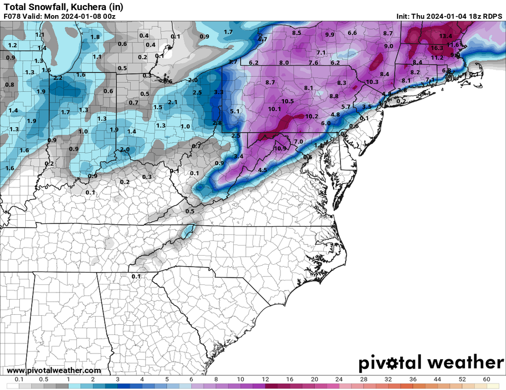
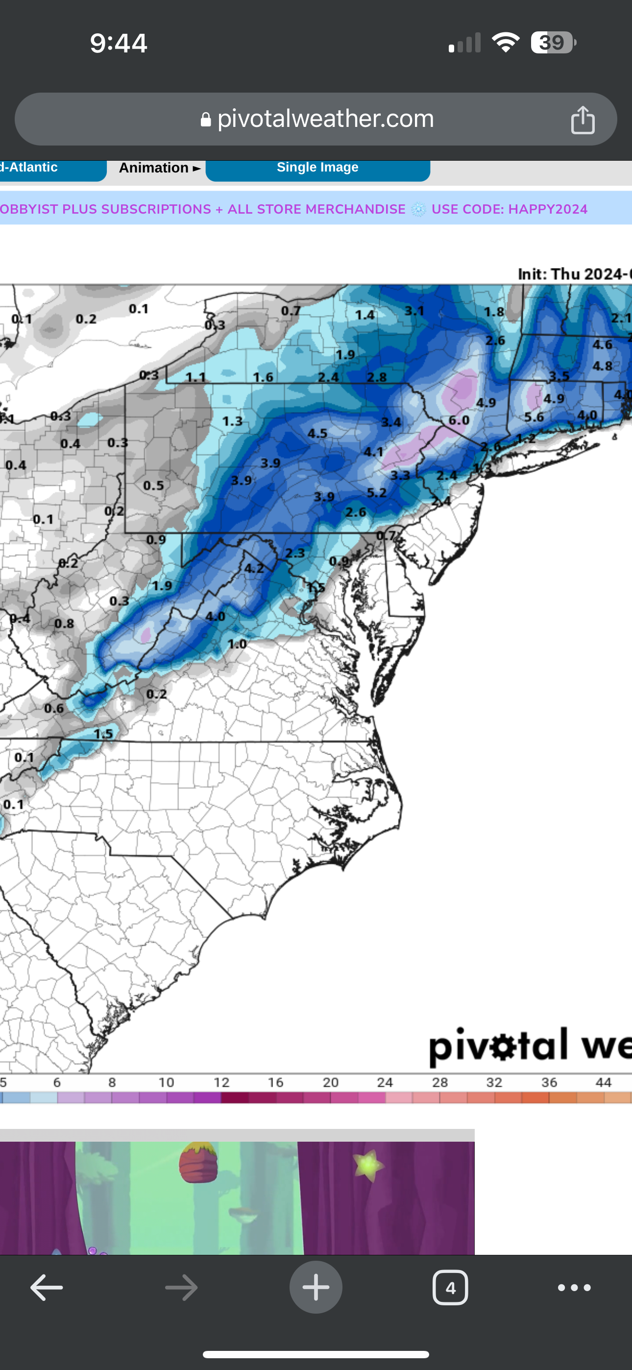
Yup. Poconos and Catskills and Hudson Valley should see a nice 4-8 from this with areas up to 10-12” isolated. Just need to figure out what location to go to.
-
1 minute ago, Nibor said:
wut…?
No worries. It was another poster who seemed to dislike a post I made that was directly from the NWS. no biggie.
-
2 minutes ago, MJO812 said:
Rgem is also colder and further south and east.
Similar axis as all models but brutal cut off
-
 2
2
-
-
4 minutes ago, BoulderWX said:
Weird flex but I don’t take it personally. They’re is a reason they have their degrees and were casual observers (most of us). But posting colorful maps gets more interest despite being wildly misleading. Everyone’s entitled to their own opinions, just not facts *shrug*
Also this FWIW…. Subject to change of course as new guidance rolls in..
-
 1
1
-
-
4 minutes ago, Stormlover74 said:
He weenie'd your post showing the nws snow forecast
Weird flex but I don’t take it personally. They’re is a reason they have their degrees and were casual observers (most of us). But posting colorful maps gets more interest despite being wildly misleading. Everyone’s entitled to their own opinions, just not facts *shrug*
-
1
-
-
1 minute ago, Stormlover74 said:
Damn weenieing the nws
Huh?
-
6 minutes ago, Franklin0529 said:
That second wave. It's becoming stronger a stronger dampening out the first wave. Something to watch like tip said yesterday in here. If it trends stronger city gets in on the goods
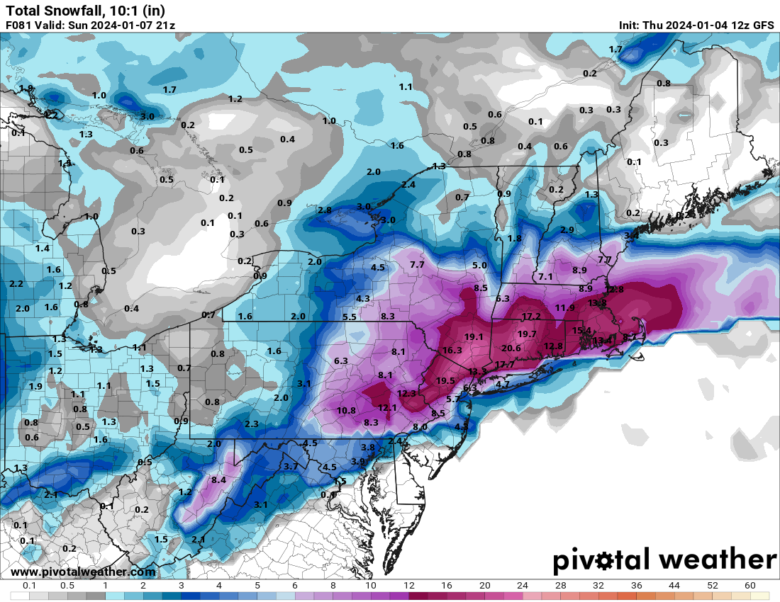
This is hilarious and never will happen with marginal temps and all that but even half of this at 5:1 would be amazing for most.
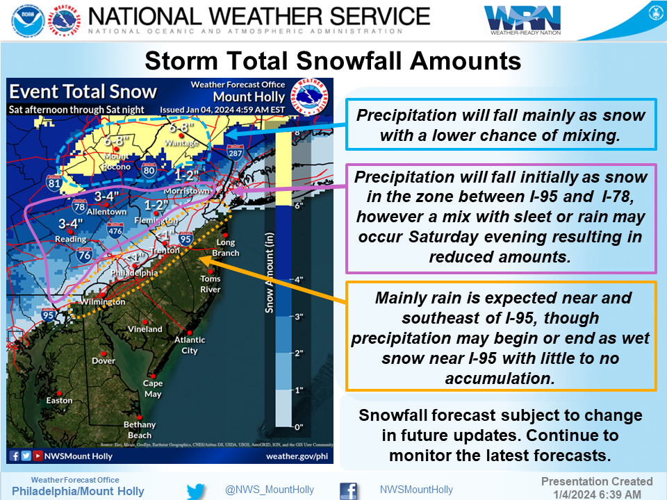
I think NWS is playing it smart with the WSW for morris county of 4-8: https://forecast.weather.gov/showsigwx.php?warnzone=NJZ008&warncounty=NJC027&firewxzone=NJZ008&local_place1=Morristown NJ&product1=Winter+Storm+Watch&lat=40.7979&lon=-74.4782
-
1
-
-
10 minutes ago, forkyfork said:
snow maps are useless junk. look under the hood
Completely agree. People posting 10:1 verbatim when many locales will be half of that. And compacting. Just not realistic. I’d cut 10:1 in half if you’re within 50 miles of the coast. 8:1 seems reasonable well north and west IMO
-
2
-
-
45 minutes ago, ForestHillWx said:
The ensembles haven’t moved much for my area; arguably they have increased chances for significant snows.
MMU and points north/west should be in the game.
I’m in Morristown and right in the line. Either way ratios will be very low but would be nice to see flakes fly.
-
1 hour ago, binbisso said:

This is hilarious and without any support. Also be careful with 10:1 as many have stated before, looking closer to 5/6:1 along coast and other marginal areas.
-
15 minutes ago, nightknights said:
When will you ever learn if you are in the bullseye 6 days out you will not be in the bullseye game time
Said this yesterday and one poster thought I was just being pessimistic. Have a place booked in the poconos but now thinking Catskills might be a better bet.
-
1
-
-
I meant “not” very impressive. Fixed in previous post.
-
13 minutes ago, TriPol said:
I don’t think nyc sees its first inch of snow yet. Too warm.
Maybe a slushy mix. Doubt most places in NYC see more than a slushy inch or two.
-
NAM long range - its not very impressive but at the end of its range
-
 1
1
-
-
10 minutes ago, qg_omega said:
This looks pretty reasonable
Agree
-
2
-
-
Just now, Allsnow said:
Further south this run leads to more snow by the coast

Yikes.
-
2 minutes ago, Typhoon Tip said:
Sure... there are two short waves really in contention for the Jan 7 event.
The first is being influence by the 2nd, further upstream.
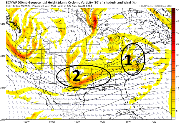
The 2nd one labeled "2" ...overtakes the lead ( complex physical interaction involving wave mechanics) and eventually subsumes the wave space, which you can see below ...
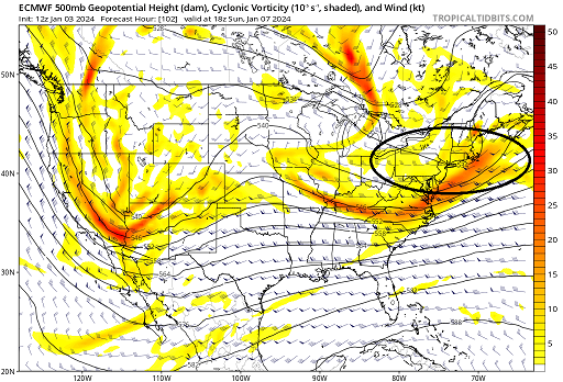
If you go any of the sites that carry these free graphics and animate the 72 thru 108 hour Euro solution from 12z, you can get a sense of how this happens in fluidity.
But ...this 102 hour chart above has captured the surface low that the original "1" triggered, and gives it a goose ( so to speak...) intensifying it further.
“Gives it a goose” - best comment of the thread and great, easy to understand explanation.
-
2
-
 1
1
-
-
Improvement from 12Z. All I can take away from it. Ping pong continues.
-
1
-
-
81 is pretty for the NYC folks
-
Just now, Stormlover74 said:
No
At 69 it was. Next two frames looking promising.
-
Through 69, GFS looks like a strung out mess
edit: won’t let me upload image
-
Just booked a place in the poconos just in case. Let’s go!!!
-
2
-
 2
2
-
-
GFS rolling… let’s see what kind of solution it spits out this time
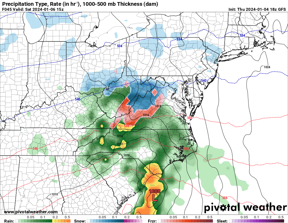


Two Mdt to high impact events NYC subforum; wknd Jan 6-7 Incl OBS, and mid week Jan 9-10 (incl OBS). Total water equiv by 00z/11 general 2", possibly 6" includes snow-ice mainly interior. RVR flood potential increases Jan 10 and beyond. Damaging wind.
in New York City Metro
Posted
51 - low in proximity/heading towards OBX. Let’s see what next few frames bring