

White Gorilla
-
Posts
2,674 -
Joined
-
Last visited
Content Type
Profiles
Blogs
Forums
American Weather
Media Demo
Store
Gallery
Posts posted by White Gorilla
-
-
3 hours ago, EastonSN+ said:
Thanks for this Don, a break from the cold with energy savings will be welcome!
I am rooting for an earlier flip to warm to allow for a better chance for a possible late winter return.
A break from the cold will feel nice.
-
51 minutes ago, MJO812 said:
Long ways to go for winter
You said long way to go for winter. I declare you a weenie because I can.
")
-
 1
1
-
 1
1
-
-
42 minutes ago, eduggs said:
I hate this winter. Still waiting for a solid snow and nothing promising to track. Monday doesn't have much of a ceiling. The wettest models (and ens individuals) are rain. It's a lousy setup. Maybe interior SNE and especially NNE has a shot.
I hate this winter too so far, though I realize it could be worse. But constant shaft city is no bueno.
-
20 minutes ago, wdrag said:
I disagree... I'll post a one liner when I admit winter over.
I'll need updated info on 3/1 Stratwarm possibilities ( not skilled at new EC methodology). IF that stratwarm doesn't materialize, then winter possibly done, but for now... I am not believing 00z/5 EPS at 360 hours.
If I'm not mistaken 2-3 weeks ago posters were looking for a warmup soon after the first week of Feb. Becoming clearer (to me) that this persistently warmer than normal (no winter here) warmup is delayed til at least the 19th (maybe even the 23rd since AK troughs have a delayed 4-5 day east coast response).
Keeping in mind that this LaNina is not behaving traditionally and that there is so much we don't know...I am holding off on pronouncing winter over. Clearly the 06z/5 GEFS is not winter over as the broad trough with multiple embedded short waves covers N. AM with ridging near both coasts. Modeled ensemble EPO are nearly polar opposites by 336 hours.
If you want some confidence in the GEFS EPO at 336 hours... take a look at this Relative Measure Of Predictability (RMOP) attached. Reds are above normal chance of verifying. The Blues below normal., So if you look at AK, the blues might end up warmer (ridging)... I sort of doubt that the 500MB heights will end up as a colder trough there...my thinking the error is that the GEFS heights are too low there.
I always end with that I could be wrong-corrected but for now... am reluctant to be a downer.
14.4" Wantage as of 908A/5(keep an eye on 7-8 coastal... it should produce snow and ice near or just west of I95 RDU-ORH)

Thanks for your post Walt, but careful, Snowman19 might put a weenie tag on you saying winter isn't over....

-
 1
1
-
9
-
1
-
-
Finally turned to snow here in Poughkeepsie. Large fluffy flakes. If only the whole show was that. Lucky those who got that north and west.
-
3
-
-
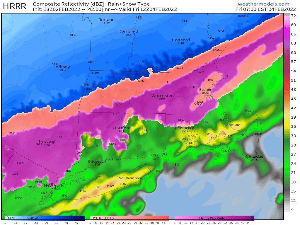
6 minutes ago, HVSnowLover said:
I'm surprised it didn't mix with a lot of sleet up there or maybe it did and still didn't matter, either way rough storm.
I had more sleet here in Dutchess at lower elevation at the same latitude.
-
State of emergency for Ulster County just to my west with up to half inch radial ice accretion there, half the county without power, many limbs and wires down, reports of people trapped in trailers. Praying for the most vulnerable there. They really got the worst. Grateful my area in Dutchess escaped the worst by an icy hair.
-
1
-
-
37 minutes ago, IrishRob17 said:
Glad to here you’ve flipped for now, really hoping for the same down here
Stay safe and warm
-
1
-
-
4 minutes ago, IrishRob17 said:
I hope you guys in Dutchess are holding up well…
Thanks. ZR has turned to a sleet snow mix for now at 26F. Power outages are exploding everywhere, sparks of light from transformers were seen earlier
-
26F here in Poughkeepsie. ZR has turned to sleet. Power outages exploding all around
-
12 minutes ago, HVSnowLover said:
The frontal boundary seems to be around Southern Ulster/Southern Dutchess right now.
34F in Poughkeepsie
-
8 minutes ago, chietanen said:
I’m about ten miles north of Poughkeepsie and my PWS temp has dropped from 40 to 31 in the past two hours or so. Also up to 0.96” of rain today.
Good to see you back. In Poughkeepsie at 37F currently, was 39 an hour ago.
-
-
9 minutes ago, wthrmn654 said:
Hrrr seems to of drastically changed at 00z. Not surprising
How so?
-
-
27 minutes ago, Monmouth_County_Jacpot said:
Can’t do anything else he’s a limited poster I wonder why. LOL
Like I said before, trolling on a weather forum is the last place I would expect to see it, but here we have one. It's sad.
-
1
-
 2
2
-
1
-
-
7 minutes ago, Juliancolton said:
As always, it bears remembering that QPF falling as freezing rain isn't the same as the eventual glaze thickness. In excellent conditions, radial ice accretion to liquid ratios are around 0.3:1 or 0.4:1, with horizontal accretion around 0.75:1. So 0.5" of "freezing rain QPF" will not be half an inch of ice sitting on power lines.
Thank God!
-
30 minutes ago, Juliancolton said:
This winter has been ok, despite the rather dismal YTD snowfall totals. A cold January with no major thaws is like winning the lottery these days. A couple respectable snowfalls in the next 6-8 weeks will make it a tolerable season.
I appreciate the cold and semi snow cover. I just want 1-2 winter storm warnings and 6+ inch snowfalls, ideally one of those a foot plus. I realize there have been winters when we have done a lot worse, but it's a bit tougher when the screw zones are so loud. The rest of Feb looks like decent potential for us, fingers crossed.
-
1
-
-
30 minutes ago, SnoSki14 said:
Feb 10-20 could be a good period. PNA expansion out west into Alaska giving us colder air downstream.
Maybe that will be the miracle time when my area doesn't get the shaft for once
-
1
-
-
I see a theme this winter. Poughkeepsie is the screw zone capital of NYS. Too far north, too far west, too far East, now Friday, too far South. We covered all the directions, yaaay!!!
Giving this winter my middle finger
-
1
-
-
27 minutes ago, HeadInTheClouds said:
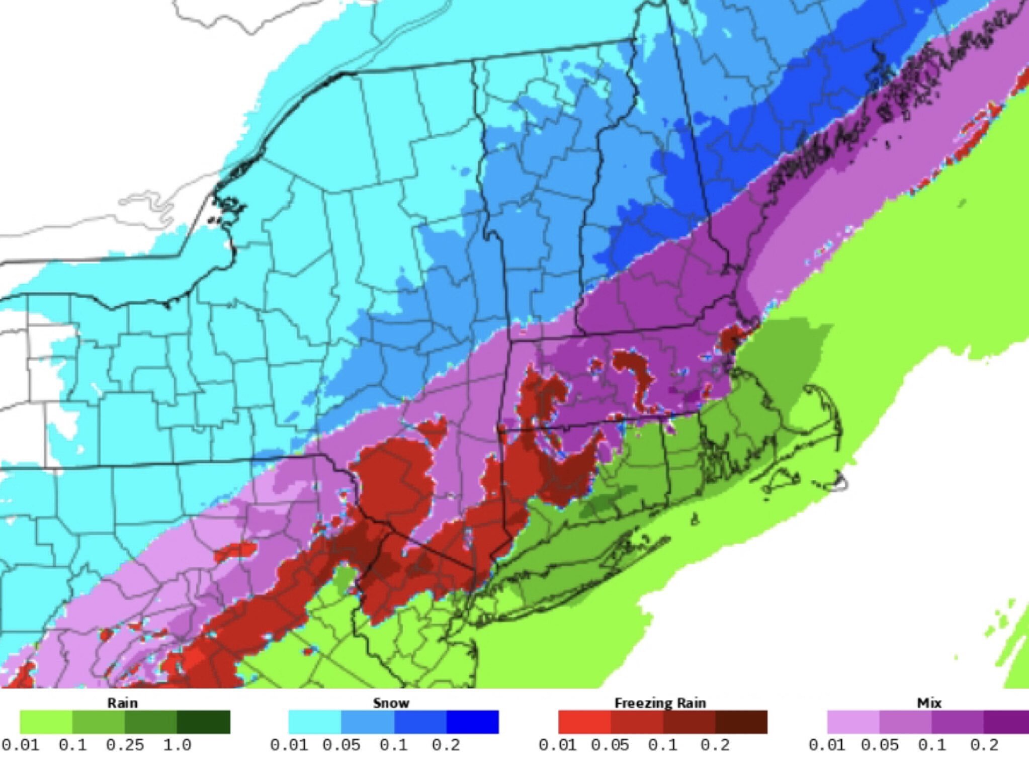
When I said somebody is going to get a serious ice storm I didn't mean NYC in particular and the 1 inch is likely way overdone. You are right though, right now N and W most likely and I'm 80 miles north so I'm concerned.
Hoping more sleet than ZR
-
2
-
-
22 minutes ago, gpsnavigator said:
Apocalypse if the GFS is right about the ice, especially eastern PA into north Jersey.
Iceocalypse? Let's hope not
-
2 hours ago, EastonSN+ said:
Yikes so this would be a disaster and take effect late March and potential ruin spring.
Cold and rainy spring with maybe an April snowstorm thrown in
-
4
-
 1
1
-
-
9 minutes ago, HVSnowLover said:
I think we just keep have to follow the track of the low and placement/strength of high, that should ultimately tell the story in terms of precip types.
If ice it is, let's hope more sleet than ZR.

Winter Banter
in New York City Metro
Posted
Hats off to pro mets, you math geniuses. I wanted to become a pro met as a kid but my math skills weren't my greatest strength.