

White Gorilla
-
Posts
2,674 -
Joined
-
Last visited
Content Type
Profiles
Blogs
Forums
American Weather
Media Demo
Store
Gallery
Posts posted by White Gorilla
-
-
Even if so, question is still where this exactly sets up
-
11 minutes ago, wishcast_hater said:
Maybe an inch of snow in Dutchess. Very light. Kinda lame
Stupid shadowing off the Taconics.
-
19 minutes ago, HVSnowLover said:
12Z GFS says yes but a day later
12Z CMC says yes
12Z Euro says no
Going to be a long week of model tracking
Hopefully we all get the result we want this time around
-
 2
2
-
-
1 hour ago, wdrag said:
The moderators should collaborate and let me know if they want me to change the thread strategy. If they feel this is not of detrimental value, then they will let me know. Moderators: all yours.
Walter, your posts and threads are the ones I look most forward to seeing here. Your wealth of knowledge and analysis is gold. Please continue as you were. Most of us here are super grateful for your contributions.
-
7
-
-
3 minutes ago, MJO812 said:
So you are going with an op run that's definitely going to change instead of a well thought post by a meteorologist?
I like LC too. I definitely take his posts with attention.
-
1
-
-
-
3 minutes ago, HVSnowLover said:
The good news: Models bringing in precip slightly faster around 7/8 pm which means metro area may get an hour of frozen at the start
Bad News: Upper levels torching so fast that now even I84 corridor is pingling before midnight tomorrow.
Wow, pinging earlier than thought? What a shocker.... Not!
-
 3
3
-
-
13 minutes ago, HeadInTheClouds said:
I saw 84, my bad. I'll put you back on ignore and save us both the headache. It's still not a non event whether it's rain, mix, or snow. It will still have an impact especially with that wind potential.
Definitely going to be a lot of impact
-
Looking forward to later Monday when this disappointing and painful mess gets out of the way and we can look forward to more snow potential the rest of the month. Tracking this thing all week is tiring especially when the results are putrid.
-
3
-
-
32 minutes ago, jm1220 said:
With this map at 850mb you aren't staying snow for very long in this subforum. It shows 70-80 knot ESE flow at that level. 700mb shows 60-70 knot SE winds. That warms mid levels in a hurry. I don't think it rains well inland, like near I-84 but prepare for a letdown if this happens and you're expecting much snow.
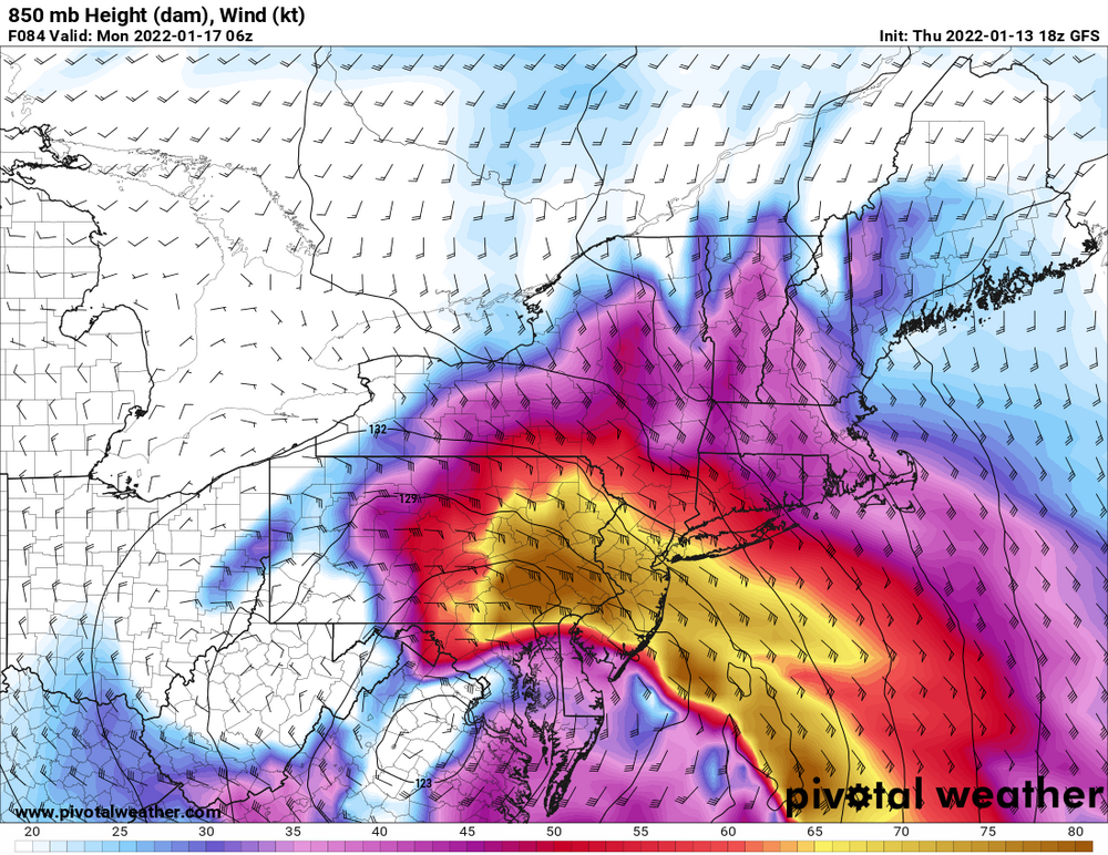
Only expecting a few inches at best up here
-
3 minutes ago, jm1220 said:
Those snow maps are likely showing a lot of sleet as snow until you're well north in New England or west in PA/NY. The mid level low tracks are horrible- winds at mid levels are out of the E/SE and strengthening. And the GFS usually doesn't see the mid level warming soon enough. NAM is better with that which we'll see a few runs from now (if the overall setup doesn't improve). I've gotten burned numerous times with seeing big snow totals on maps with bad mid level low tracks. It'll change over way sooner than it thinks now.
I learned my lesson a long time ago to expect a sleet change over much sooner than forecasted. Will never make that mistake again to underestimate mid level warming.
-
2
-
-
16 minutes ago, HVSnowLover said:
On a positive note at least the pattern is still fast flow and we are not missing out on an absolute monster, this is even 12-18 inches in the jackpot zone which isn't that high for a storm of this intensity.
Remember last December 17 2020 when a coastal storm way over performed for the Binghamton, NY area? They were only progged at 12-18 but they received 30-40 inches, what many attributed to higher SSTs and moisture influx.
-
9 minutes ago, mikem81 said:
THe entire h5 would need to shift 100 miles southeast to avoid sleet at this point.

-
14 minutes ago, IrishRob17 said:
Its a base builder.
Yeah, good snow preserver too. Any few inches of snow we get will be protected for a while especially with the current pattern holding
-
1
-
-
14 minutes ago, wishcast_hater said:
I will take sleet over rain - the kids can still go sledding.
80’s and early 90’s all over again. Except this time I’m 70 miles North of Manhattan
I am in Poughkeepsie. Yeah, sleet is a nice snow preserver, so whatever snow we get will stay for a while
-
3 minutes ago, snowman19 said:
Beware those 10:1 ratio maps on Pivotal weather, it’s counting sleet as snow. Look at the mid-level low tracks, they are west of us. The midlevels are going to torch, a lot of that is going to be sleet and not snow
Have to agree even up here near 84. More sleet than snow sadly.
-
Everyone up here ready for another sleet fest Sunday night?
-
1
-
-
A lot of mental gymnastics here to the point we pretzel ourselves.
-
5 minutes ago, Brian5671 said:
and remember the mid levels often torch faster than modeled-how many times do we go to sleet much earlier than forecast (or go to sleet when no forecast existed for sleet)
Yup, expecting only a few inches of snow up here near 84 before a sleet fest
-
-
4 minutes ago, eduggs said:
I'll pass. mid-level lows ticked west. The surface features are deceptive. It doesn't really matter where the L is placed on the surface chart. There can be many relative minimums in the pressure field. This still tracks and occludes too far west for anything more than a relatively brief thump. We need real shifts, not wishcasting ones.
Mid level lows going west means more ice than snow up here near 84
-
6 minutes ago, jm1220 said:
Pretty straightforward for us actually. This strongly favors a rain event for people near the coast and a mix or mix to rain inland. We need for the Op runs to be a huge error at this point or a major trend east starting today. It’s unfortunate but it’s what it is.
Problem is that we really don't know yet what it is given the high divergence of solutions still.
-
1
-
-
5 minutes ago, HeadInTheClouds said:
This thread has seemed to have gone off the rails
Look, I know model chasing is stressful, but come on now...
-
 1
1
-
-
38 minutes ago, VideoBufferMX said:
The problem here is (some people do not like snowing). SNOW helps better than cold rain cooling these abnormal summer heat waves at 2m levels rising IR (hot air parcels). Heavy rain in the month of January is not OK. Otherwise we deal with bow echoes... derechos significantly enhanced tornadoes. Something extraordinary we do not want to deal it. Thunderstorms are lightning abundant (abnormal as well). We do not want to deal with excessive lightning and excessive electrostatic discharge at the pole grounding wires inside apartments, buildings, houses.
So this is another storm which I believe better produce the snow and move out as usual this means possibly 12-18in event for I-95 (Central NJ) not saying 24"+ not out of the question. It will move out as usually quickly...
This wave is strong and I haven't seen an analog looking like this. This energy might just be small piece of a big puzzle or larger system that seems like a long duration opportunity and having stalling characteristics.
COMMENT: FUNNY ISN'T IT? THEY TALK LIKE THAT ::: SOME OF THESE WAVES ARE SO STRONG THAT THEY ACQUIRE VOICES AND RETURN BACK TO THE DROPSONDES...
I AM LIKE WORKING IN THIS AREA OF TALKING VIBRATIONS READING CRYPTOGRAPHY STATEMENTS BASED ON RECONS...Uhhh......

-
1
-


Interior NW & NE Burbs 2022
in New York City Metro
Posted
Certainly no over performance east of the river. Next please. The sooner this shush storm gets behind us, the better.