.JPG.b4e83aadd99c39a6a799f453c94452e8.JPG)
J.C.
-
Posts
761 -
Joined
-
Last visited
Content Type
Profiles
Blogs
Forums
American Weather
Media Demo
Store
Gallery
Everything posted by J.C.
-
If you haven't noticed, this is a Raleigh heavy subforum. Atlanta posters should probably spend as much time reading the Tennessee Valley su forum. Raleigh not getting any snow is the reason for this thread.
-
At least there is football...
-
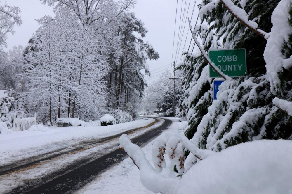
I stole the second pic.

-
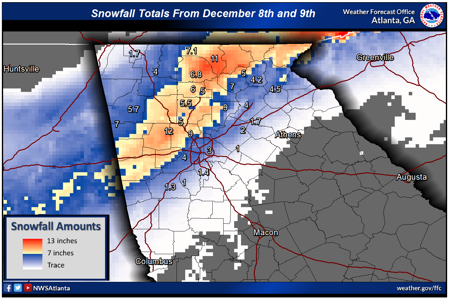
We had 10" The NWS map had a foot on the Cobb/Paulding line over a good chunk of area.
-
Mountain City, GA -18" Cobb County GA-12" Just two of many places around here.
-
It really does have to be a perfect set up. You need a parent high in the northeast and the storm a good ways off the coast for anything. Columbia only has one wind direction that can bring in cooler air and that is northeast. North and northwest are downsloping winds.
-
.thumb.JPG.31210124b742ef17be141b392a43be90.JPG)
The December to Remember 7th-8th blue turd winter threat thread.
J.C. replied to lilj4425's topic in Southeastern States
I can't believe the models are showing a deformation band for tonight, crazy. -
The December to Remember 7th-8th blue turd winter threat thread.
J.C. replied to lilj4425's topic in Southeastern States
Winter Storm warnings now from the western suburbs of Atlanta northeast to the mountains, I guess the models finally triggered it. -
The December to Remember 7th-8th blue turd winter threat thread.
J.C. replied to lilj4425's topic in Southeastern States
There is the cold front draped across the south right now just north of Atlanta, I'm sure as the storm moves east it will pull some drier/cooler air in from the north. -
The December to Remember 7th-8th blue turd winter threat thread.
J.C. replied to lilj4425's topic in Southeastern States
There isn't a map, just points on the map of major airports. http://www.spc.noaa.gov/exper/sref/srefplumes/ -
The December to Remember 7th-8th blue turd winter threat thread.
J.C. replied to lilj4425's topic in Southeastern States
SREF mean for ATL is 1.88" GVL 2.75" GSP 3.72" -
The December to Remember 7th-8th blue turd winter threat thread.
J.C. replied to lilj4425's topic in Southeastern States
Mine too! -
The December to Remember 7th-8th blue turd winter threat thread.
J.C. replied to lilj4425's topic in Southeastern States
RGEM 18z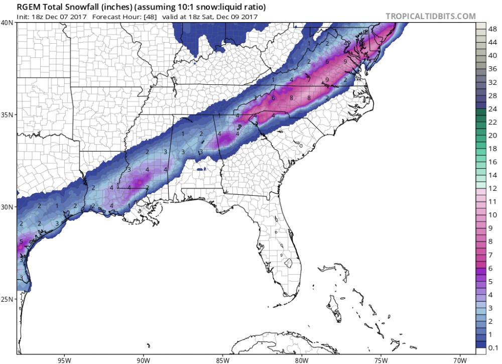
-
The December to Remember 7th-8th blue turd winter threat thread.
J.C. replied to lilj4425's topic in Southeastern States
Very interesting. Models must be picking up on some increased precipitation bursts. Thanks for sharing. -
The December to Remember 7th-8th blue turd winter threat thread.
J.C. replied to lilj4425's topic in Southeastern States
I didn't realize there was a second front that the low was going to ride from Texas, that front is currently stretched from San Antonio to Pittsburgh. Once that low passes to the south, the cold air will be brought in, to what extent is always a guess. -
The December to Remember 7th-8th blue turd winter threat thread.
J.C. replied to lilj4425's topic in Southeastern States
Euro looks good, but like others have said, it could shift slightly after one more run, but we are now inside of 24 hours. I would also take what you see here and divide by 3 outside the mountains. -
The December to Remember 7th-8th blue turd winter threat thread.
J.C. replied to lilj4425's topic in Southeastern States
There is no way to accurately forecast this, to many variables. Anywhere in Atlanta could see all mixing, or you could get lucky and get some heavy wet snow bursts that stick to elevated surfaces for a few hours. Folks on here could give you a much better analysis, but from what the models are telling us, expect nothing to a slushy inch that might hang around a few hours. Roads will be unaffected until after midnight Friday night. -
The December to Remember 7th-8th blue turd winter threat thread.
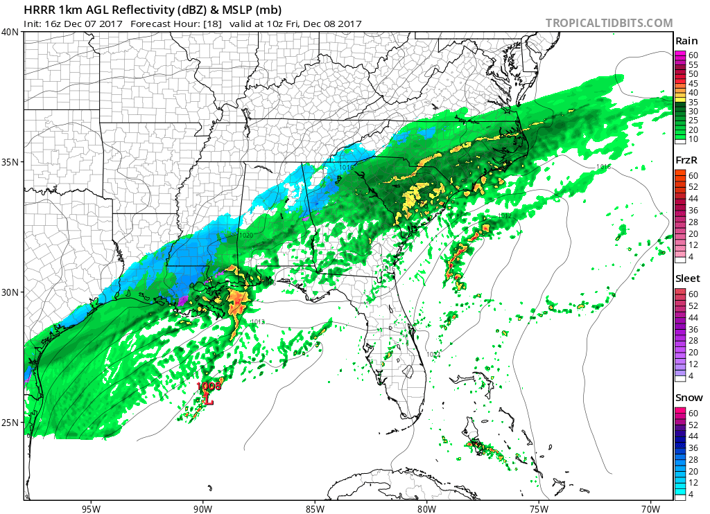
J.C. replied to lilj4425's topic in Southeastern States
16z HRRR
-
The December to Remember 7th-8th blue turd winter threat thread.
J.C. replied to lilj4425's topic in Southeastern States
http://www.spc.noaa.gov/exper/sref/srefplumes/ select total snow and use the map below to select a location -
The December to Remember 7th-8th blue turd winter threat thread.
J.C. replied to lilj4425's topic in Southeastern States
Rather big NW trend on the NAM, climo.... -
The December to Remember 7th-8th blue turd winter threat thread.
J.C. replied to lilj4425's topic in Southeastern States
SREF mean for ATL is 1.5" and GSP is 1.89" -
The December to Remember 7th-8th blue turd winter threat thread.
J.C. replied to lilj4425's topic in Southeastern States
I thought the Euro had kinda sat between the two... -
The December to Remember 7th-8th blue turd winter threat thread.
J.C. replied to lilj4425's topic in Southeastern States
I can't believe the original outlier GFS is going to win this one. Just goes to show you, pick the warmest or driest model when it comes to winter and stick with it. -
The December to Remember 7th-8th blue turd winter threat thread.
J.C. replied to lilj4425's topic in Southeastern States
Yep, all hail the GFS. -
The December to Remember 7th-8th blue turd winter threat thread.
J.C. replied to lilj4425's topic in Southeastern States
Precip shield further north at 22