
slow poke
-
Posts
360 -
Joined
-
Last visited
Content Type
Profiles
Blogs
Forums
American Weather
Media Demo
Store
Gallery
Posts posted by slow poke
-
-
7 hours ago, RogueWaves said:
It is amazing, and we're pretty fortunate to have this option during winter. Many states west of us don't. They don't get the extra snow from the GL's like we do. Even more contrasting can sometimes be seen in early spring. I remember back in the 90's we'd be downstate for Easter holiday visits and there would already be greened-up lawns in April due to T-storms. Then drive back home outside of Traverse and there'd be an iceberg of condensed snow a foot deep and Peeps crossing the hwy on snowmobiles. '86 was even more extreme. Folks going up to their cabin for Easter break and having to plow 24" out of their driveways just to get in. And that was in NEMI, not even the classic snowbelt zone. Do you remember the infamous ABC news footage back in May of '82? On World News Tonight they did a story about the Regan era military build-up and somehow decided on footage from Camp Grayling as their example of troops in training. Here it was a warm May day and these soldiers are running around in the 18" deep remainder of the awesome snow pack from that legendary winter! You want to see when Alpena was raking, check out their snow totals all thru the 80's.
Alpena has really been in a snow drought the past 10 years or so. My aunt and uncle used to live on Long Lake just just north of town, we would go there snowmobiling back in the early and mid 90’s before we had our own cabin. I remember back in the winter of 95/96 going up there and the big round bails of hay, the 5’+ tall ones, were almost completely covered out in the farm fields where we would ride, just incredible deep snow for anywhere in MI let alone north east Lower MI. North of Alpena around the Roger City area does get quite a bit of lake effect snow off of Huron though.
-
 1
1
-
-
3 hours ago, Snownado said:
2 months ? Met Spring begins in 26 days
I feel the “Met” seasons fit for the most part at least in south east MI. To me March-May are Spring ish months, can you get winter and summer weather during that time frame, absolutely. Just like we can get Fall and Spring type weather in the “Met” winter months of December-February. In northern MI, March is definitely a winter month, no question but down here it fits in the Spring category I feel. For what it’s worth my deepest snow depths up at our cabin have almost always been the first week of March since we’ve had a place up there the past 18 years.
-
1
-
-
On 1/30/2020 at 10:12 PM, michsnowfreak said:
Haha strictly just conversation. I love our entire state and all the lakes that surround it. I will be in Munising February 16-19, and looks active here before that, so hoping for lots of winter fun!
You should have decent snow up in Munising when you’re up there. My bro n law just got back from snowmobiling up there all weekend and said there’s pretty good snow but they could definitely use more. On our way home from our place up at Higgins yesterday there’s good snow till you get just south of west Branch, then it’s like a switch and someone turned off the snow. We have about 14” of really heavy snow at our place right now. It’s crazy that 175 miles north and 400 feet of elevation can look so different then around home, it’s like a totally different world with deep snow, people out ice fishing compared to home with extremely green grass for this time of year and no ice on any lakes to be found. It kinda reminds me of out west in the mountains when you can have warm weather and bare ground down in towns and valleys at lower elevations and deep snow just a hour or less just up the mountain.
-
1
-
-
1 hour ago, Hoosier said:
I would dispute the active part a little bit. I guess it depends on how you define the word and where you are. There were those couple unusually early storms in Oct/Nov. Then there were a couple significant storms in different parts of the sub in December, but I wouldn't really call that "active" overall. You expect some storminess... this isn't the desert. Recall that December was quite bad and boring in those areas that missed out on the bigger storms that month (ORD could hardly buy a drop of any kind of precip in the first 4 weeks). January has been better in terms of storm frequency and hopefully we build on it and get some bigger storms.
I agree, lots of rain during December and January doesn’t equal a active time to me. When I hear people say “ but we’ve had average snowfall to this point” I can’t stop thinking it sounds like a Detroit Lions fan when they say “but we had the lead in all of our losses this season so we’re so close to being a good team”
-
So does this mild stretch we’re in the next week or so count as our January thaw or do we actually need to be froze first before we can count this as a thaw? I’m really looking forward to spring, I can’t remember a warmer or wetter December and January for my area. There’s only been about 3 or 4 weeks of safe ice the past 3 winters combined out on Anchor Bay, that’s pretty crazy to think about, definitely not normal.
-
9 hours ago, michsnowfreak said:
Snowfall is absolutely increasing in the Great Lakes. Detroit just finished its snowiest decade on record, and without all the numbers in front of me I imagine most of the Lake belts did as well.
I would be interested to see how the lake belts are doing if it were broke down by decade. To me it seems like the belts in northern lower MI had more snow back in the 90's but that's just me thinking back with nothing to base that off of other then snowmobiling up there since the mid 80's and always trying to find the deepest snow to play in when we could. The UP MI belts seem like they haven't changed much over the years to me, they pretty much always have great snow in the areas I have been going to for the past 30+ years. The SW MI belts seem like they have seen a decline to me, growing up my best friend had family in Paw Paw that we would go visit often and I remember them having crazy deep snow a lot of the time when back here in SE MI we would have very little. Now it seems like they don't get all that much more then what we get out this way. A big question I would ask is have the measuring techniques of the snow changed over the years at all and could that have a effect on the overall increases in the long term averages? Like measuring 2x a day verse 1x or certain times of the day type thing. I have no idea how "official" measuring is done but have wondered if the techniques have changed at all over the years could that have any effect on the long term averages?
-
10 hours ago, josh_4184 said:
Ended up with around 12", if the LES would of panned out would of been better. Still looks like mid winter p here finally. around 20-22" OTG. Took about 2 1/2 hours to clean up the property. Haven't posed much pics this winter as been busy with family and renovations. But did take some today.


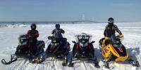
That’s about what we ended up getting around Higgins also, there was about 6-8” of really hard snow otg when we got up Friday evening and about 14-16” when we left last night. A pretty intense lake effect band nailed us for a few hours Saturday night, we picked up about 5” of fluff just from that. Great storm and great snow in northern MI right now. The snowmobiling is awesome right now up there, best January conditions in a few years our group thought.
-
1
-
-
1 hour ago, weatherbo said:
Nice pics. I don't think I've ever seen you post a pic of a sunny day. I know how you despise them.
Really enjoy the pics you and Will post, please guys keep posting them. It helps us snow starved trolls, a troll is what the Yooper's call us that live south of the bridge, remember what deep mid winter conditions are supposed to look like north of the 45th parallel. At our place at Higgins Lake which is about 30 miles south of the 45th parallel, we've had a decent amount of snow so far this season but we've had a lot of rain and warm weather in between the snows. Sounds like cooler weather "should" start kicking in latter this week into the weekend and hopefully that allow whatever snow that does fall stay around.
-
1
-
 1
1
-
-
1 hour ago, Jonger said:
Thinking about just forgetting midwest snowmobiling this year. Might do some Canadian Rocky long track riding.
Would be a good year for it.
-
1 hour ago, michsnowfreak said:
That all depends how far into Spring Winter lasts lol. November should not be discarded, that was literally as wintry is it can possibly get at this latitude at that time of year for that long. In fact, the irony of this entire thing is if November and December had been swapped, we would think nothing of it.
I would consider November having 7 days of true winter like conditions after the Veterans Day snow storm at my place where we had a little over 10” on the ground after that storm. It left the grass covered and looked and felt like winter for that week following the storm.
-
1
-
-
1 minute ago, michsnowfreak said:
Last Winter was not anything special in the snow department, but I cannot believe how many ice storms we had in the Detroit area. We never get ice storms and we had 3 or 4 last year. The late January historic cold snap is absolutely something engrained in my memory, but it will be the only thing i remember from that Winter years down the road, everything else was forgettable, especially with so many heavy snow records set the past 20 years. With a snowy November and another late Spring, it definitely seemed like a long Winter, however for most of December into the 1st half of January, Winter was a no show except for the usual mood flakes. The 2017-18 Winter was a much much much snowier Winter here in Detroit. In the UP however, last Winter was epic for snowpack, even more so epic when you consider it was wiped out before Christmas in most spots.
Good point snowfreak about the UP rebuilding their crazy deep snow depths after many areas were down to very little snow starting January out with. At our place at Higgins Lake there was no snow at Christmas and the snow really didn’t start kicking in till mid January, once it started snowing though it got deep up there till the second weekend in March. They also got a few big snow storms in April that added to the season totals but only stuck around for a couple weeks. I really thought we were due for a good snowy long winter this year but with December being a no show again this year even if we start getting winter weather in January it going to be another short winter season in lower MI.
-
6 hours ago, Jonger said:
Jesus. Looks like we're going to pay for last years good winter. Just canceled 2 weekend trips to the U.P.
All Michigan snow will be wiped out.
Funny how people can look at things so differently when it comes to weather. Just talking MI I thought last winter was “ok” at best except for the UP snow belts. Even there the season started a little later then normal I thought but once it got going it was good up there. The season seemed really short to me, about mid January to early March, in the lower even though snow fall was about average from West Branch north. Down state I thought the winter was really bad if you’re a fan of cold and snow. We had a cold outbreak in January for a little bit but I don’t remember anything other then that actually. As far as the snow being wiped out in the UP, I think they’ll be ok up there, they have a really good deep base already. I bet you would be fine to still go up and ride for the foreseeable future. Just my take but again, everyone looks at things different.
-
1
-
-
1 hour ago, weatherbo said:
Went to po box this morning. Took a couple pics of my road. It's been pretty much one vehicle at a time for a couple weeks. Luckily, rarely pass anyone on it this time of the year.


Awesome pics Bo, what's the elevation where your place is at and how long does it take you to get down into Marquette roughly? I would have to think the Huron's have some of the deepest snow depth right now not only in MI but the mid west. Not sure what its like out east in the higher elevations or snow belts right now but you might have some of the deepest depth east of the Rockies.
-
I really don’t have any thoughts making me think my state, MI, will be snowier/not or colder/warmer then normal this winter other then thinking everything “averages” out over time normally. Playing the average out with time game would have me thinking south east MI “should” have a little more snow then normal with average temps. Probably snow around the holidays to make up for last year even though Christmas of 2017 was incredibly snowy at my house in the southern Thumb area. Northern MI has really been a different situation though, the snow belts have been averaging about normal snow the past 20 years but outside the main snow belts it’s been a different story. Our place up north, 10 miles south of Grayling, averages about 90” of snow per season, 9 out of the past 19 seasons have been below average, 9 have been about average with only 1 season, 2008-2009, being above average. To say the non main snow belt areas are due for a above average snow season would be a understatement. Is this the new normal up there? Maybe but I feel northern MI is probably due for a above normal snow season with about average to slightly above temps. Just my thoughts as a weather observer for nearly 50 years, not a professional meteorologist.
-
1
-
-
Big chunk of the lake belt areas in MI are really starting to have it pile up. My cousin's place half way between Paradise and White fish point in the UP has 30" on the ground as of this morning according to his snow removal guy. Looks like these areas are picking up right where they left off last spring with a deep snow pack.
-
2
-
-
1 hour ago, weatherbo said:
No, not really.
Low of 2 overnight.
I was up in your neck of the woods Sun-Mon at Northern MI university, my son had a scholarship competition thing up there, man is that campus in a beautiful spot. Marquette is such a cool town, I can see why you choose to live up there Bo. Drove through a whiteout heading home Monday around lunch time on the Seney stretch, looked to be about 16"-20" in a spot along there and that was before all the snow they got Mon evening into yesterday.
-
We rode about 40 miles yesterday evening, just out to dinner to Grayling and back and hit some two tracks on the way back. They groomed Friday night so the trail we rode was really nice except that stretch right along the freeway going into town. About 6” of heavy snow up there but you don’t have to go very far south to start seeing grass. Houghton lake south is more grass then snow.
-
Starting to look like northern lower and the UP will be in good shape for outdoor winter sports activity after this storm hits tomorrow night with 2-4” of heavy wet snow in northern lower and 4-8” in the UP. It’s probably going to rain some in northern lower Monday for a while but with the snow on the ground now and what additional they get on top of it with this storm it should make a great base because of the high moisture content in it. System snow makes the best snowmobile trails base. After this storm some off and on lake effect snow should only help to get the trails and slopes in good shape moving forward into mid January and beyond. We’ll see how all this shakes out over the next few days but I feel it should be good for outdoor winter activity’s finally. South in mid Michigan and down I’m thinking it might be awhile before we see any decent cold or snow that sticks around. Wonder what the least amount of snow Detroit has ever had for December and January combined is because this past December and now January would have to rival it I would think. One good thing about hitting rock bottom is you can only go up from there so next December couldn’t be any worse could it?
-
1
-
-
6 minutes ago, BuffaloWeather said:
How much? Looking for a Double.
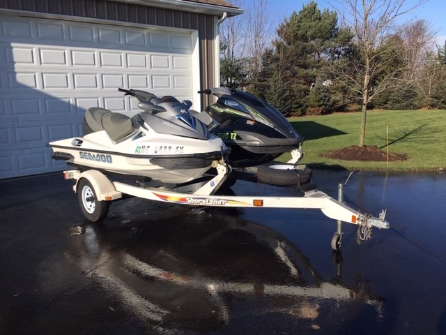
They are both 3 seaters, the Seadoo is a 05 with about 100 hrs on it, the Yamaha is a 09 with about 70 hrs on it. I'm going to ask $3,500 for the 05 and $5,500 for the 09 and $600 for the trailer. The 09 is supercharged and will go 70 mph on a gps, the 05 is not and will go around 55 mph.
-
3 hours ago, josh_4184 said:
You definitely picked a great year to head south as Hell week this year is not going to happen (feel bad for the businesses) , maybe small portion of the UP but if their is any snow will be toast with every rider heading that way. Hopefully Mid-Jan we can get some snow, but EL-Nino winters are historically pretty bad for Norther Lower.
It's tough for most of the small mom and pop places to make it up there with snow for us down state's to come up and ride on and spend money Dec-Mar. With no snow and people coming up in Dec and especially hell week it's going to be really tough for them.
-
1
-
-
1 hour ago, BuffaloWeather said:
Get some jet skis they’re more fun anyways. You can use them May-September every year. I plan to get one soon, a bunch of my buds ride every weekend all summer.
I have 2 of them for sale if anyone is interested, haven't used them much the past two summers and need the room in the barn.
-
This will be the first time since 1997 that we won’t be up north between Christmas and New Years, in 97 we didn’t go up because of the weather, this year it’s because we’re going to Florida. When we booked the trip back in May I wasn’t really happy because I thought we would be missing out on a week of snowmobiling, now it’s looking like we picked a good year to go down there. A group of us are heading to WY snowmobiling for a week in early Janurary, hopefully the cold and some snow will kick in by the time we get back from out there because it’s not looking to good between now and January. Probably should have kept our razor, at least we could have been out riding some and stayed warm when’s there’s no snow. I did put 25 miles on my TW 200 yesterday though on the back roads around home. Felt like a early spring day.
-
14 minutes ago, Jonger said:
Basically now through Dec 22nd is toast. Lots of guys riding around in circles in the Grand Marais to Paradise to Newberry triangle.
Some guy on my FB page said he put on 300 miles this weekend up there.
My cousin's place half way between town and the Point got a foot of fresh snow Thursday-Saturday morning on top of the hard crusty snow they had left. Down in town got less then half of that. Snow is pretty good north of town along the lake shore heading toward GM. People have been riding up there since Thanksgiving. It's not great but it's a start.
-
1
-


February 4th-7th Winter Storm Potential
in Lakes/Ohio Valley
Posted
Snowing hard here in the southern thumb in the Mitt, northern St Clair county, have between 5”-6” on the ground now. Actually looks like a mid winter morning out there for a change. Going to have to plow the driveway for only the 3rd time all winter, once in Nov, once in Jan and now today. We have to run into town tonight, Port Huron, there should be more snow over that way if this wind direction keeps up for a while.