

schoeppeya
-
Posts
579 -
Joined
-
Last visited
Content Type
Profiles
Blogs
Forums
American Weather
Media Demo
Store
Gallery
Everything posted by schoeppeya
-
Eye coming into view on the key west radar
-
I don’t know how much to value it but just for trend it’s basically steady state on intensity between now and landfall
-
Yeah have to think the next 10-12 hours are the best remaining window of higher water temps and lowish shear. Should be solidly over the loop current now
-
Does like maybe the beginnings of a new outer eyewall/secondary wind max as well?
-
Literally rides the northern side of Tampa Bay as well
-
18z HAFS B initialized about 35 mb too high
-
Don't be sorry, I am wrong all the time! ETA: I measured and youre right its pretty stable in size right now
-
The eye is really contracting again... I wonder if we will see another EWRC and intensification phase while conditions are still very favorable tonight into tomorrow morning
-
Almost perfect IR presentation again. I don't think we will get there but just given the overall look I wouldn't be shocked if we make a run at yesterdays numbers.
-
HAFS-B still wants to ride the north side of the bay but the hurricane models are becoming outliers on that at this point
-
Wow that IR presentation escalated quickly
-
I dont know if they missed it as much as the center was in between data readings because the eye is so small... waiting for that dropsonde
-
No signs of an ERC yet
-
They should be basically through a pass, last update on TT is from almost half an hour ago and they were just outside the CDO
-
Going to be a biblical run, eye still condensing and cloud tops still cooling
-
The stuff these hurricane hunters do inside storms makes me feel like an absolute fool for any type of flight anxiety I have.
-
Eye really clearing on IR, pressure likely going to continue to crater.
-
Considering we are on the cusp of 5 already I think that's almost a lock at this point
-
HWRF continues to show worse case scenario for TB. Actually re-deepens in a few mb before landfall.
-
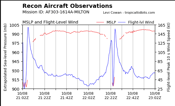
10mb drop in between passes?!
-
Looks like a steadily/rapidly intensifying hurricane to me.
-
Yeah, was implying if it already looked like that before the damn failure its probably going to be completely washed out for a long ways.
-
This this is beneath where the dam just failed, they have have to rebuild a huge stretch of it
-
That first plane earlier tried and decided thanks but no thanks and went home.
-
Pretty incredible to see the similarities between this storm and Michael. The IR presentation and evolution approaching landfall is even remarkably similar


