

NycStormChaser
-
Posts
2,374 -
Joined
-
Last visited
Content Type
Profiles
Blogs
Forums
American Weather
Media Demo
Store
Gallery
Posts posted by NycStormChaser
-
-
I'm not sure where you are but it's coming down nicely in Brooklyn.Not a flake has fallen the last two hours that weak stuff from Connecticut is not sticking.
Sent from my SM-N950U using Tapatalk
-
Impossible. Everyone here insisted it was over1.2" since the snow started about an hour ago
Sent from my SM-N950U using Tapatalk
-
Radar filling in nicely. All the stuff in CT should pivot around.
Sent from my SM-N950U using Tapatalk -
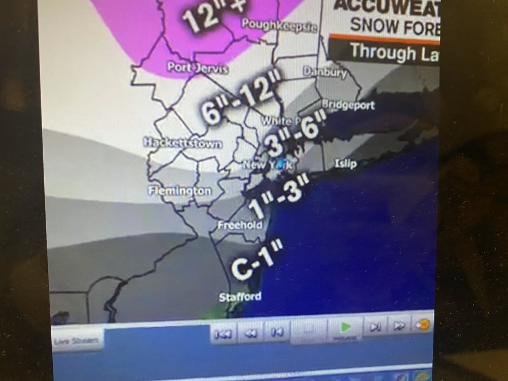
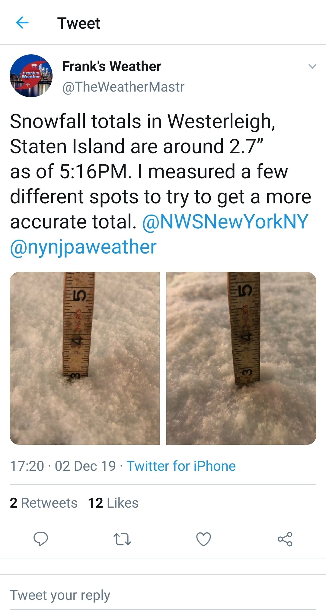
And there were a few 2 to 2.5 inch reports in Staten Island.Central park recorded 1 inch
Sent from my SM-N950U using Tapatalk
-
 1
1
-
-
-
People have been saying that every every time a storm bust the past 50 yearsThis storm has been nothing in Jersey City everything is wet no one will trust the weather people anymore.
Sent from my SM-N950U using Tapatalk
-
1
-
-
I'm live from Parsippany if anyone is interested. Fat flakes coming down www.twitch.tv/Nicholasisabella
Sent from my SM-N950U using Tapatalk -
ABC upping totals
-
2
-
 1
1
-
-
I wish we went back to storm mode where the admins deleted all the dumb replies in this thread.
Sent from my SM-N950U using Tapatalk-
2
-
-
To Imply nws let's what happen last year affect their forecast now is horse crap to be honest. Cmon that's just not true. And people have to let the storm finish up before jumping ship.Exactly. Will there be some places that end up under a band a get a few inches? Yep. But it's 2PM. And it's looking more and more to me like if you want to accept reality, this was way overblown (probably because of the mishap last year where that major storm was underforecast in advance). And I'm not so sure the NWS has been "decent". They started out with 6"-12" north/northwest of NYC. Then 3"-6". They're still showing 5"-10" for northern Westchester. Depends upon how you define "decent".
Sent from my SM-N950U using Tapatalk
-
2
-
-
Sorry. I just re read what I wrote. Yes there would be more cold air in our area.More snow on the back end quicker? I fail to understand your logic there.
Do you mean there's more cold air around and it's drying up the front edge of the storm and the deeper cold air means more snow on the back end? But as Long Beach Surfer said, the mid levels are warmer than they were forecast to be.
Sent from my SM-N950U using Tapatalk
-
That also means we will have more snow on the back end quicker.Not a big fan of the fact that the start time keeps getting pushed back. It’s more likely now that precip starts as a mix now rather than as snow.
Sent from my SM-N950U using Tapatalk
-
1
-
-
Latest from Upton

-
1
-
-
I think it's been mostly city talk because it's such a marginal location for this storm. Anyone north and west of the city will do great. 25 or 30 miles in either direction you'll really see an uptick in these numbersAny Indication on how this will turn out for MMU? Seems like a lot of city talk here.
.
Sent from my SM-N950U using Tapatalk
-
1
-
-
I don't see any reason except for getting dry slotted why NYC won't see a solid 2 to 4 inches of snow. Watch out where ever that heavy band of snow setups as well. That area will do the best. Almost all models have it happenening but we never know the location until it's now casting time. Enjoy the first snowstorm of the season everyone. I'll be heading north to gather some photos and videos today and back to do the same in the city tomorrow.
Sent from my SM-N950U using Tapatalk
-
1
-
 1
1
-
-
The snow flakes lasted about 10 minutes here in Brooklyn.Hrrr has this going until 2 or 3pm
Sent from my SM-N950U using Tapatalk
-
Looks like NJ and possibly NYC will see it's first flakes after all today around the 1pm hour as precipitation back builds a bit to our southwest
Sent from my SM-N950U using Tapatalk-
1
-
-
1 hour ago, donsutherland1 said:
Last year, was sort of a special case. One was dealing with a rare near-term forecasting failure. On account of the high impact of that failure, the effects of that outcome will likely continue to guide decision making for some time to come.
During the morning of November 15, moderate snow dumped more than the anticipated amounts in both Baltimore and Washington, DC where 1.7" and 1.4" snow fell respectively. Neither city had expected more than a coating of snow.
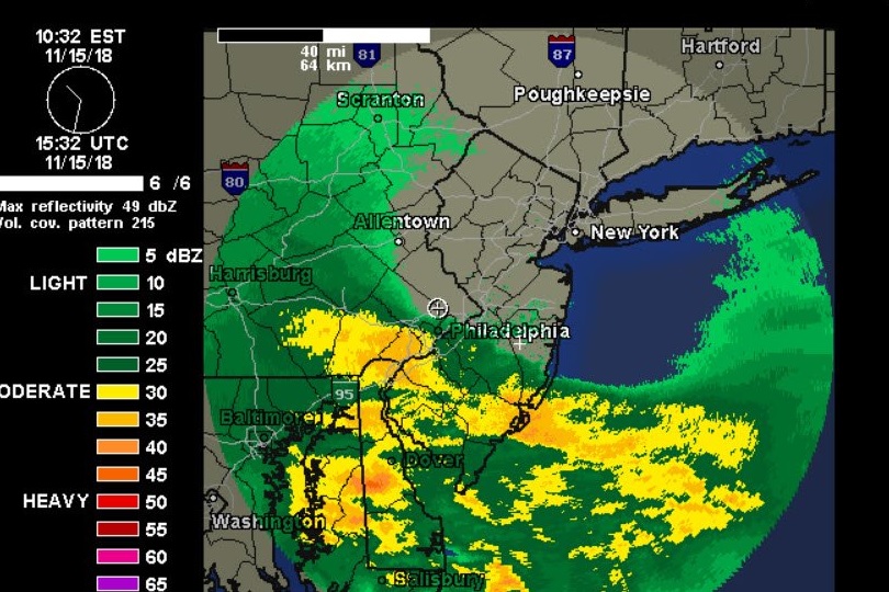
By late morning, heavy snow was moving into the Philadelphia region:
By 1 pm, Philadelphia had experienced 1/4-mile visibility and 2" of snow had fallen.
At that point, based on an absence of news reports noting significant pre-positioning of equipment and pre-treatment of roads prior to the onset of the heavy snow in the New York City area during the afternoon, either the NYC Sanitation's forecasters were largely oblivious to what was going on south of the City or the NYC Department of Sanitation was taking things too lightly. More than likely, one was dealing with a combination of those two scenarios: low forecaster and Department awareness of real-time events.
The New York Times would report a situation that implied that New York City's leadership had been governed by the early forecasts. The newspaper reported, "Leaders in New York and New Jersey came under heavy criticism, but insisted that they had been caught off guard by the ferocity of the storm after early forecasts predicted just a dusting."
https://www.nytimes.com/2018/11/16/nyregion/snowstorm-total-delays-commute.html
Largely unaware of how things were evolving, the City was caught unprepared for what proved to be a moderate snowstorm (though record-breaking for the date).
Around 2 pm, heavy snow pushed into midtown Manhattan. Streets were then rapidly covered by the heavy snow. By the time the storm ended, New York City had picked up a November 15 daily record 6.4" snowfall.
In the post-mortem, the City's political leaders shifted significant blame onto commuters for clogging the streets. That happened after the heavy snow was underway. None of that takes away the reality that the City still had several hours to react to a situation that would wind up much worse than the early forecasts had its forecasters and decision makers observed what had happened in Baltimore and Washington and what was underway in Philadelphia.
Not to blame commuters, but most people who turned on the morning news weather reports only saw an inch or two in the forecast. If the idea of this storm over performing could have been relayed before the morning commute then 50 percent of the cars and trucks would not have been out there.
-
1
-
-
Just now, Snow88 said:
It's certainly possible if the cold air comes rushing in with a few hours to go. Flash freezes can cause some accumulations but I'm not expecting anything here. I do think everyone will see a change to snow .
But none of the models show NYC getting an inch. Be realistic or this is going to be a painfully long winter.
-
4
-
-
11 minutes ago, Snow88 said:
Nam has about an inch for the city
Not even close to that. Stop exaggerating. 3k nam has 0.2 for the city. But it will be 39 degrees or so when the precip moves through so I doubt it sticks.

-
1
-
 1
1
-
-
Long term forecast are a joke and hardly verify.88, long term predictions are hard ? How about one of us try and figure out what is hell is going to happen short term / the 13th and 14th of next week ?????????

Sent from my SM-N950U using Tapatalk
-
2
-
-
9 minutes ago, NYCweatherNOW said:
GEFS IS A SNOWSTORM FOR NEXT WEEK 6-12 inches
It's going to be a long winter
-
1
-
6
-
-

Sent from my SM-N950U using Tapatalk -
Ef2 confirmed last night near Philly. https://forecast.weather.gov/product.php?site=phi&issuedby=PHI&product=PNS
Sent from my SM-N950U using Tapatalk-
3
-

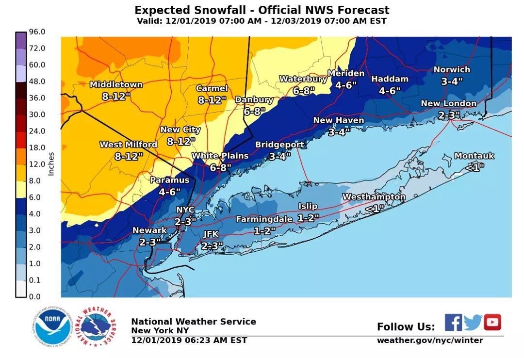
Possible Dec 1-3 Winter Storm
in New York City Metro
Posted
Sent from my SM-N950U using Tapatalk