
MIstorm97
-
Posts
363 -
Joined
-
Last visited
Content Type
Profiles
Blogs
Forums
American Weather
Media Demo
Store
Gallery
Posts posted by MIstorm97
-
-
Got an amazing 1.0” in Berkley so far for an event total. Underperforming even my low expectations. Really hate to see it.
-
50 minutes ago, michsnowfreak said:
all snow here but not sticking. can't complain as east side should get the best snow tonight.
Same for here, had good rates but just couldn't stick. The snow board and some grassy surfaces had a slushy tenth for like 15 minutes. A friend in Novi posted a picture in a Twitter chat I'm in and they have about a solid inch covering all grassy and elevated surfaces. That extra few hundred feet of elevation really helps in these scenarios, plus being farther away from the water.
-
 1
1
-
-
3 hours ago, Hoosier said:
Rough times for the shoreline
Lakeshore Hazard Message
National Weather Service Chicago IL
942 AM CST Sun Nov 29 2020

INZ001-002-292345-
/O.CON.KLOT.LS.W.0009.201130T0600Z-201201T1800Z/
Lake IN-Porter-
942 AM CST Sun Nov 29 2020

...LAKESHORE FLOOD WARNING REMAINS IN EFFECT FROM MIDNIGHT
TONIGHT TO NOON CST TUESDAY...

* WHAT...Significant lakeshore flooding and shoreline erosion
  expected due to large waves of 13 to 17 feet and high lake
  levels.

* WHERE...Lake IN and Porter Counties.

* WHEN...From midnight tonight to noon CST Tuesday. The worst
  conditions are expected Monday and Monday evening.

* IMPACTS...Numerous roads closed and low lying property
  including parking lots, lawns, and homes and businesses will
  be inundated near the lake. Some shoreline erosion will occur.

* IMPACTS...The large waves combined with high lake levels will
  exacerbate beach and shoreline erosion. Additionally, a one foot
  increase in the water levels is possible along river mouths,
  canals, and ports along Lake Michigan. Low-lying property
  including parking lots, parks, paths, lawns, and structures
  along the immediate lakeshore will likely be inundated. Numerous
  road closures are possible. This includes East Lake Front Drive
  in the Beverly Hills area. Stay dry when waves are high!
The parking lot at the beach in New Buffalo is still partially destroyed from the spring. That’s probably going to get wrecked more tomorrow. Wonder if Lake Front Drive in Beverly Hills will crumble away more. Between the lakeshore flooding/waves and the LES, it should be intense tomorrow
-
1 minute ago, IllinoisWedges said:
HRRRV4 has a pretty insane LES band all day Monday and getting even more juicy by sundown.
You already know we're gonna be in that band intercepting and seeing the large waves. Should be a fun day, then I arrive home as the snow is ramping up in DET.
-
1
-
-
Lakeshore flooding aspect of this storm looks decently significant for Southern Lake Michigan. A recent comparable event would be March 6th, 2020, which had significant erosion, flooding, and damage in NW IN and far SW MI. I'll probably go check out the high waves and flooding, especially since there should be some decent LES as well.
-
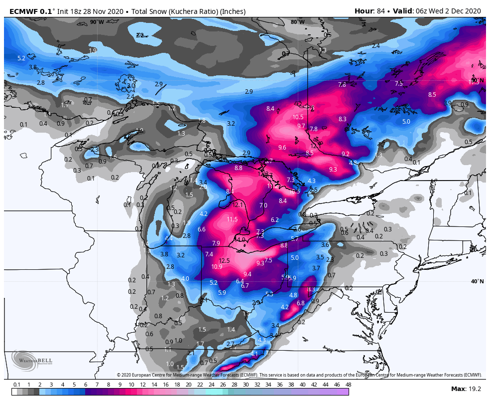
Some 18z Euro weenie hype for the board
-
3
-
 1
1
-
-
Old habits die hard
last winter was missed phase after missed phase. Why change that now
-
2 hours ago, thomp2mp said:
Can confirm, I've got a little over an inch here in White Lake at 1050 ft. Starting to stick a little on the pavement as well.
Just now got to 1.0” in Berkley. Been sitting just south of the best FGEN banding all day except for like a 30 min burst. Also have been right on the edge of the marine air influence. Warmer by the lake comes back to bite. At least it’s November
-
Flake size has been improving over the last hour. It’s a shame this event is happening with marginal thermos. The extra 500’ of elevation in the NW suburbs appears to be helping things stick more than downwind of the glacial ridge.

-
Been a minute since I’ve come on here. Life has been extremely busy with finishing college. Graduate in just a couple weeks.
Got my first 0.1” of snow for the season on the 16th.
I was on the Lake Michigan shore for the wind/wave event on Sunday. While *quite* as impressive as what happened on Lake Erie, there were still 15-20 footers on the lake. Gusts around 60mph caused tree damage and minor structural damage. The waves lashing the shore were just insane. Definitely a little larger waves than the November 1st gale.


Video:
-
12
-
-
Last weekend was perfect for fall colors in Munising and Pictured Rocks. Will send a couple shots here. Going to continue to enjoy this beautiful weather before it turns colder again.
-
1
-
-
Starting off October with a sweet foggy sunrise
.thumb.jpeg.56c598054e760028cca2c8199ecd0bf4.jpeg)
-
5
-
-
20 hours ago, weatherbo said:
I'm sure there's decent color, just maybe not peak yet. Although I'd imagine there are areas along Newberry/The Seney Stretch that are peaking. The progression of the change is rapid day to day right now. Leaves are falling quite a bit here , even with no breeze.

I'm very torn on whether to head up this weekend. The weather isn't looking great, but clouds can still work for fall foliage. I really want to get the fall colors with multiple waterfalls in the Pictured Rocks area (Miners Falls, Sable Falls, etc). I'm limited in my time being up in the UP because I'm doing student teaching right now. For sure next weekend, but maybe this weekend too.
-
11 hours ago, michsnowfreak said:
Actually that's not too difficult for DTX or GRR because of how much they love the old "Winter weather advisory" . We had at least one, maybe 2 of those busts last Winter alone. But in a great Winter we would see many more. I notice that GRR as the worst. 1 to 3" of Lake effect snow? They issue a Winter weather advisory. 5 to 8" of synoptic snow? Winter weather advisory lol
I do love the November storm that had widespread 8-12" totals and only a Winter Weather Advisory lol
-
 2
2
-
-
17 hours ago, weatherbo said:
The sat pic today shows the color in the high terrain of the UP nicely... my backyard is pretty much at peak. With the hard freeze and numerous frosts, it's a few days early this year.

.jpg.a84547c73406e0afd3c3ca2dd79a7485.jpg)
What does sat show for colors in the central part of the UP?
-
39 minutes ago, hlcater said:
the 2020 severe season started and ended in 45 minutes.
4/7 was okay locally, and 5/23 was fair. But the census for this season yields 2 mediocre severe events, and one exceptional one. I'd honestly trade the derecho for more/better tornado days than we had this year.
We could've dominated a massive day on 3/28 if we ended up having the forecast moisture. So close yet so far.
5/23 was decent, but definitely could've been better. Would've been nice if the NW IL tors fully condensed.
Need a Pella repeat followed by Traer the next day...with a few Rochelle and Roanoke events in IL.
-
2
-
2
-
 1
1
-
-
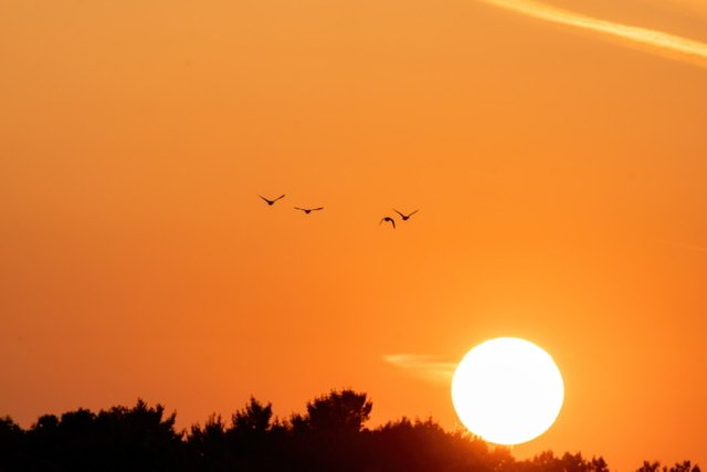
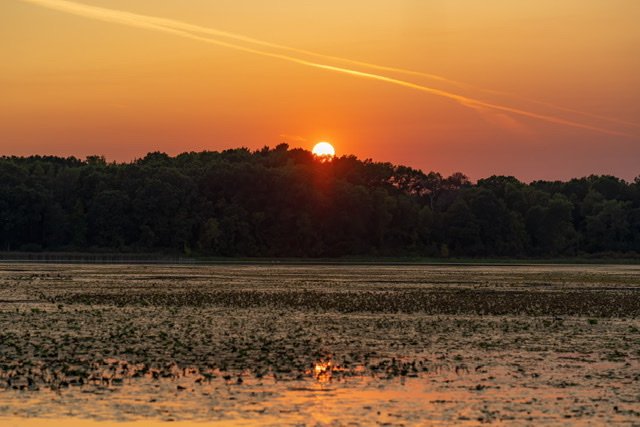
Yesterday’s smoky sunset at Kensington Metropark. This stretch of weather has been top shelf for doing anything outside.
Image compression is really doing a number on these pics

-
5
-
 1
1
-
-
1 hour ago, Snownado said:
Yeah it seems like the news is quick to point things out when things are going bad, but when things are going better they don't mention it as much.
17 minutes ago, BuffaloWeather said:Negative news sells. I wish there was a dedicated new station with all the positive things going on around the country.
Dirty Laundry sums this up pretty well.
-
On 9/19/2020 at 8:43 AM, Danny8 said:
I'm in St Helen and was in Grayling yesterday, colors have only just started up here. Maybe ~10% of trees
I'm thinking Munising area this weekend (if the weather isn't bottom shelf) and then Northern Lower the next weekend. There's multiple waterfalls I want to get with fall colors.
-
1
-
-
Thinking of heading up north next weekend for fall colors. Loving these crisp sunny days and cool nights.
-
12 hours ago, roardog said:
Strep throat? I’ve had those symptoms with strep throat before. One way to tell the difference between a sore throat from strep throat and from other illnesses such as a cold is with strep you won’t get any kind of congestion in your nose/lungs. I learned that tidbit from a doctor one time when I had it about 20 years ago.
The strep tests came back negative, but both my primary doctor and Beaumont hospital urgent care suspected it was probably still strep or a similar bacterial infection. I was tested for strep on Friday, and told that if I didn't improve in a couple days to start antibiotics. Long story short, I only got worse, so I started the antibiotics on Monday. They seem to have really helped, so I assume it did end up being strep or a similar bacterial infection. I'm not 100% better, but I'm way improved over how I was on Monday.
-
Had a scare with the virus. Got tested because of a 104F fever, terrible body pain, very bad sore throat, etc. Luckily no chest or breathing problems. The test came back negative yesterday evening luckily. Whatever I have though has worn me down to dirt. I've been doing my best with mask wearing and avoiding high risk areas. This whole situation is serious.
-
Probably should get some waterspouts this weekend on and off starting Friday with these cold shots coming in. Should get steep lapse rates and high delta T's with 850mb temps diving below 10C.
-
9 hours ago, Stebo said:
Perfect, sounds like it will be near peak when I am up there. Very excited!
Yeesh already? Been scouting out locations in Northern Lower and the UP for fall colors this year. Going to have to make a couple weekend trips this fall.
-
2
-
.jpeg.caba4f7193d3f31fee7f24ecad8eef9e.jpeg)


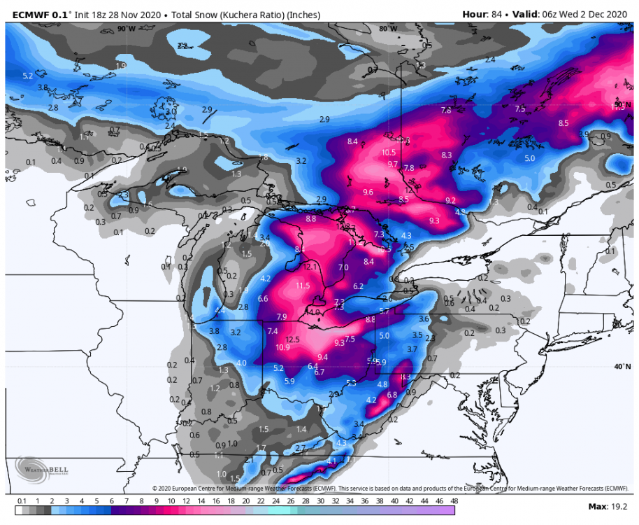
November 30-December 2 *Potential* Winter Storm
in Lakes/Ohio Valley
Posted
That donut hole over SE Oakland County into far N Wayne County on every model appears to have come true haha. Grass tips are poking out still and everything here. Probably added a couple tenths but that is it. This is what I get for being in the jackpot several times the previous few winters. It's still frustrating to be surrounded by 2.5-4" amounts and have just over an inch.