
Hoth
-
Posts
9,902 -
Joined
-
Last visited
Content Type
Profiles
Blogs
Forums
American Weather
Media Demo
Store
Gallery
Posts posted by Hoth
-
-
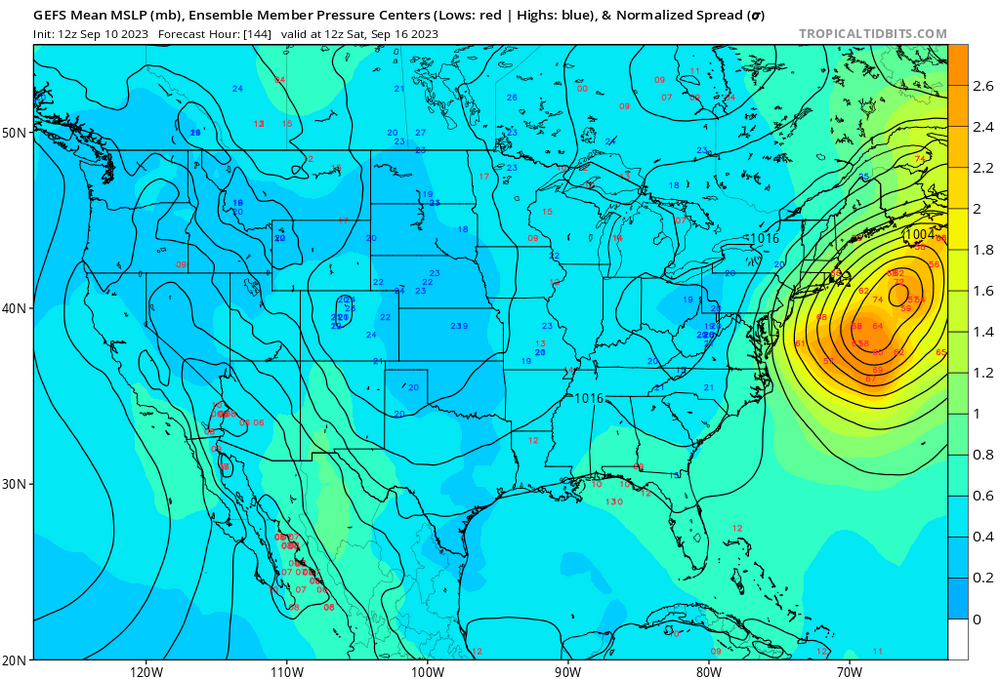
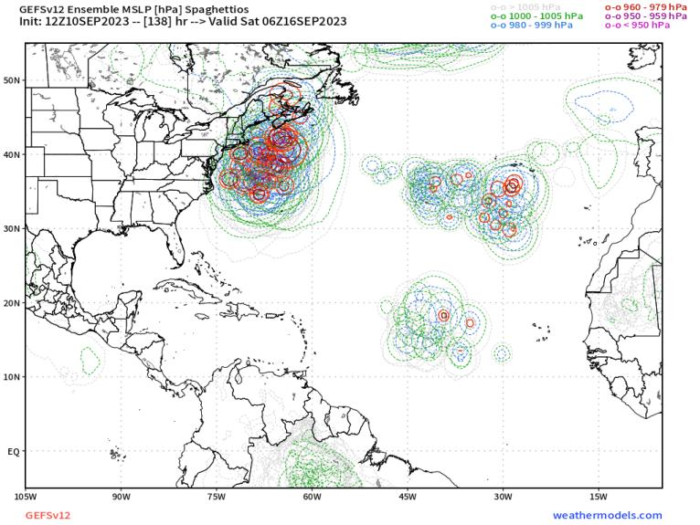
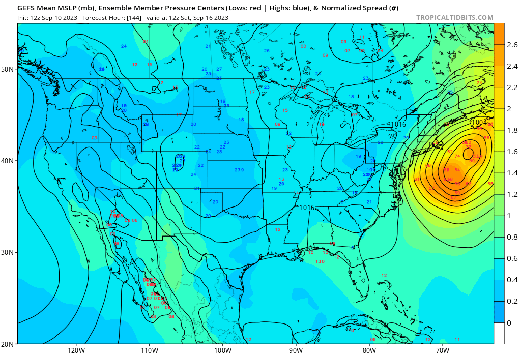
Storm already has a pretty big wind field. Is this thing getting a baroclinic assist up this way?
-
 4
4
-
-
8 minutes ago, GaWx said:
Is there a NH landfall on record? Anyone know? The 18Z GEFS has one member that just about does that. Also, two of the 18Z EPS come within ~5-10 miles.
The best part is TauntonBlizz is in NH this weekend. Would be absolutely hilarious if he got the eye up there.
-
 3
3
-
-
35 minutes ago, DavisStraight said:
Don't like golfing with wind, messes up my club selection, unless it's to my back then I can really drive the ball

As they say in Scotland, nay wind, nay golf.
-
1
-
-
10 minutes ago, Typhoon Tip said:
Until the 18z got that memo …
Almost a Fiona repeat verbatim. Imagine if that pressure record got taken down after less than a year?
-
 1
1
-
-
10 minutes ago, dendrite said:
Almost the rare NH landfall. I’m not sure if that’s ever even happened on modeling. lol
Well, TauntonBlizz did say he's going to be in NH next weekend. We know he has an uncanny ability to draw jackpots to himself, though usually he needs to whinge a bit more first.
-
2
-
2
-
-
1 hour ago, Rtd208 said:
You have my attention.
-
1
-
-
8 minutes ago, NorEastermass128 said:
There definitely seems to be a mainstream OTS camp and western camp now on the models and ENS. Interest rising.
Just interest rising?
-
EMAATT may hold true here, too.
-
Hear the thunder, but no cells within 15 miles.
-
Just oppressive down here today. Yuck. I thought we were going to get some relief this weekend, but this is just as bad as it was a few days ago.
-
5 hours ago, George001 said:
This is starting to get interesting. I haven’t really checked the models much over the past couple of days, but since I last time I looked the low location is more west than it was last time I looked. I don’t think a SNE landfall is likely, but the risk of the storm getting close enough to give us a lot of rain is increasing.
Welcome back, Georgie!
-
Just now, Cuteirishgirl25 said:
Why are you giving up? It’s seven days away.
Because our odds of getting a cane are not much better than yours.
-
Very frequent lightning from those cells to my north towards Hartford.
-
1
-
-
She gone. On to Stein!
-
23 minutes ago, Hotair said:
New England has never seen even a Cat 4 storm come onshore. Most powerful one was a Cat 3 in 1938 (New England hurricane ) which caused significant damage throughout Long Island. Needless to say, all the stick built homes and above ground utilities would be utterly destroyed if a powerful cane like Lee were to come onshore as a Cat 4 anywhere along the New England coast.
1635 would like a word.
-
2
-
-
10 minutes ago, CoastalWx said:
I'd rather see it modeled into BDR right now because of the ticks east that can happen.
Send it to Buffalo for now.
-
1
-
-
45 minutes ago, Cyclone-68 said:
Not to make light of our CT friends but the resulting power outages would probably last until the next hurricane
I’m still waiting for UI to get the power back from Isaias, so Lee doesn’t concern me.
-
1
-
1
-
-
37 minutes ago, WinterWolf said:
Ya, I don’t know about that? A big winter storm/blizzard possibility is pretty exciting, and has much better odds than a major Cane for SNE.
But, if this trends to something significant for us, then it will become very interesting, and potentially exciting if that indeed begins to unfold. But as of now I don’t feel that way. Pump the brakes currently…long way to go.
There is something special about tracking a cane. I think the most sleep deprived I've ever been was the week leading up to Sandy.
-
2
-
-
All runs are entertainment at this range. We’ll start taking them more seriously when this thing is north of USVI.
-
1
-
-
1 minute ago, ineedsnow said:
are you getting anymore interested? good trends today
Good for those without waterfront property anyway.
-
1
-
-
What's the return period for Atlantic Canada canes? Seems like they do better than down here for sure.
-
Damn what a hit for Hazey.
-
Seems like a gradual trend towards lower heights in the GL the last several runs.
-
25 minutes ago, WinterWolf said:
Off topic some, but Was just thinking how the “I” named Tropical cyclones have been so notorious….Ione, Inez, Isabel, Irene, Ian, Isaias, Isidore, Igor, Ike, Ida, Irma, Ivan, Idalia. I mean that I storm has been a bitch and infamous for many. That’s amazing when you think about it. “I” has the most retired names of any letter in the Atlantic.
Ok, back to our originally scheduled programming.
Kinda makes sense? Deep enough in the alphabet that it tends to show up near the peak of the season when climo is most favorable for powerful storms.
-
2
-
Hurricane Lee--Glorified Nor'Easter or Legit Tropical? Near Miss or Direct Hit?
in New England
Posted
ARW7 would make a lot of us sickos happy...and put us in the dark for a while.