

DeltaT13
-
Posts
3,006 -
Joined
-
Last visited
Content Type
Profiles
Blogs
Forums
American Weather
Media Demo
Store
Gallery
Posts posted by DeltaT13
-
-
5 minutes ago, tim123 said:
Winter storm warning only go to 6pm sunday will probally have to be extended till at least 12 Monday I would guess
i really want to believe that LES will last into Monday but the vertical profiles are really lacking in moisture.....seems hard to believe. That said, lake induced instability will be extreme so perhaps some extremely low level grit will be ongoing with hazy sun shining through. There is only a few thousand feet of atmosphere to work with.

-
3 minutes ago, Thinksnow18 said:
Honestly does Cuomo have many upstate supporters?
He's better than any republican. We havent found a better alternative democrat that has a chance to win so I vote for him, somewhat reluctantly....
-
 2
2
-
-
32 minutes ago, CNY-WXFREAK said:
It does.
This is from the nws website. I just took the training. There is a critical “or” in the wind section
Blizzard Warning
A Blizzard Warning means that the following conditions are occurring or expected within the next 12 to 18 hours.
1) Snow and/or blowing snow reducing visibility to 1/4 mile or less for 3 hours or longer
AND
2) Sustained winds of 35 mph or greater or frequent gusts to 35 mph or greater.
There is no temperature requirement that must be met to achieve blizzard conditions.https://www.weather.gov/lwx/WarningsDefined
-
Blizzard criteria is sometimes listed as only needing to have frequent gusts above 35 for the wind component. In that case we verify sometime overnight Saturday.
-
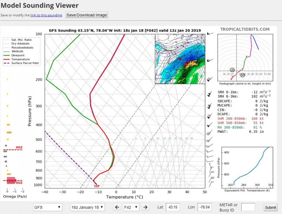
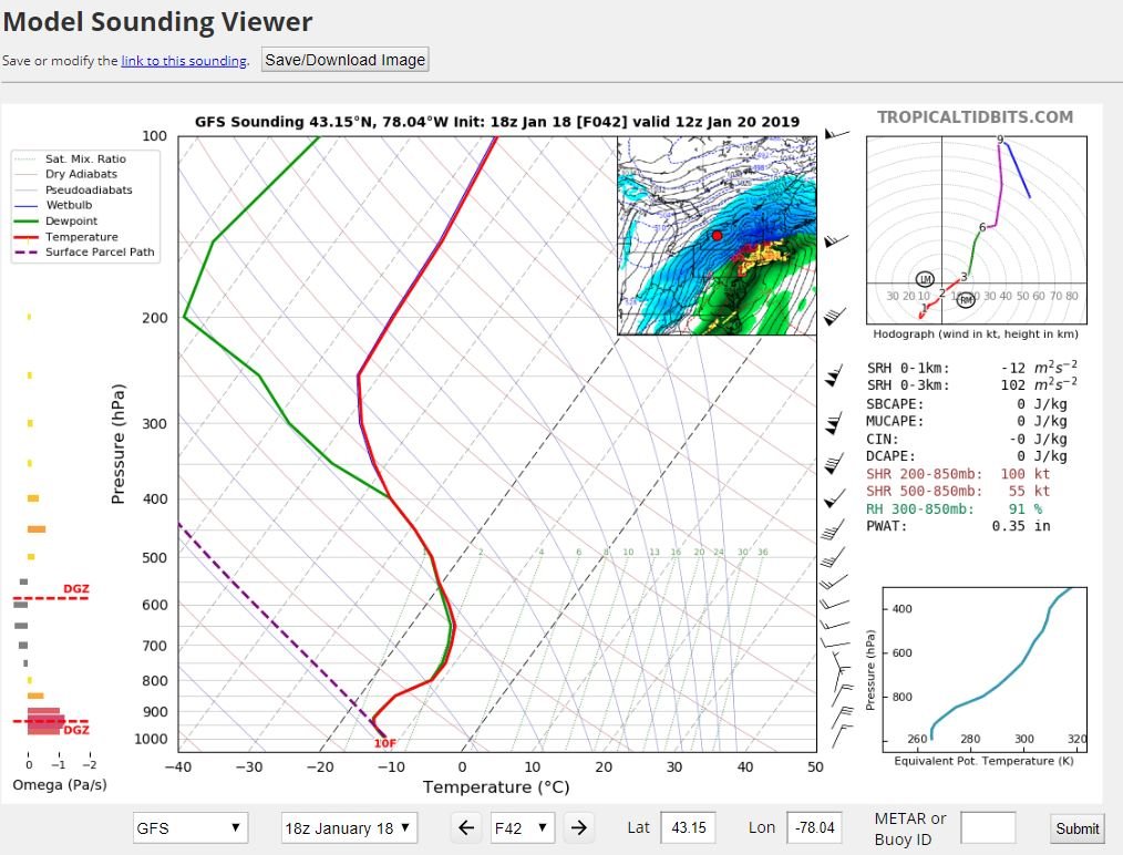
Sunday morning looks like the South Shore should really get some good lake enhancement. Unidirectional winds from the surface to 800, Delta T's near of almost 20 degrees and a column saturated to 400mb. Hot damn!
-
2
-
-
13 minutes ago, Syrmax said:
I'm probably wrong but I'm not seeing a whole lot of "redevelopmen" on these model runs...more of a Miller A system blazing by. I realize that even Miller A's often have center jumps or quasi redevelopments but not seeing that so much. Maybe a met can comment.
The further NW the low track the slower and lesser the transfer. Also, stronger systems with better upper level support (like the nearly perfectly coupled upper level jets in this one) allow the primary to maintain strength and prevent a secondary low from developing. That said, you can see this surface low getting real baggy and expanding South, especially as the front crosses the coast. It's trying, thankfully its just not happening on the these NW runs.
-
1
-
-
Been busy as hell at work all day which was actually a welcome relief from stressing about this storm, haha. Looks like things are on track though and sentiment is positive around here. Just give me a solid foot in the ROC and I'll be happy.
-
2
-
-
Just now, CNY-WXFREAK said:
I'm going to bed, I ain't doing this, no way!
I am as well, lets pray those 6z runs throw a hail mary.
-
The difference in those frames is .2 of an inch. Seems quite plausible, just not what we want. We've known that we are on a razors edge for days with this one.
-
The NAV GEM has been down in Georgia since the 6z run this morning. That model seems out to lunch.
-
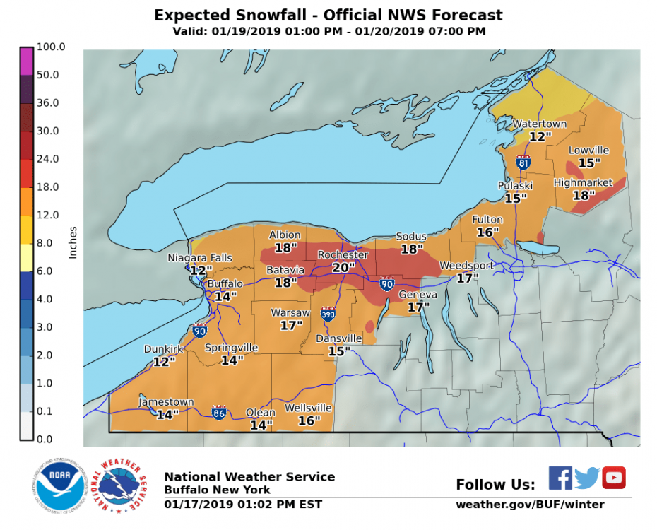
Are we starting the totals?
Buf - 9
Roc - 12
Syr - 15
-
I've seen this psuedo dry slot punching through the system the last few days. The back edge comes fast and is sharp as well so I think things will wind down fast early sunday. 9pm-3am will be the sweet spot for this one. Trying to figure out if I want to stay up driving around or get some good sleep so I can hit Bristol very early Sunday. This will be delicate balance, haha.

-
10 minutes ago, CNY-WXFREAK said:
Wow, RGEM goes into Central OH, lol!

That’s what I’m talking about! Prolong that transfer as long as possible. Would love to see more models move this way. Haha. It’s deep too!
-
1
-
-
8 minutes ago, Syrmax said:
Tonight's 00Z runs will be the first ones with our system ashore and "fully sampled." Will be interested to see if any changes show up in 00Z or 12Z upcoming runs.
The makings of our storm are currently crossing the continental divide and just about to drop out of the Rockies for some Lee Side Cyclogenesis.
-
 1
1
-
-
Just now, rochesterdave said:
It’s early, but what are the chances of a BLizzard Warning? I don’t pay attention to wind speed fcst.
I mentioned this earlier. I think we will hit the visibility aspect easily, but Gusts to 35 will be tough. I thought it would be windier but most outputs keep us in the 20's.
-
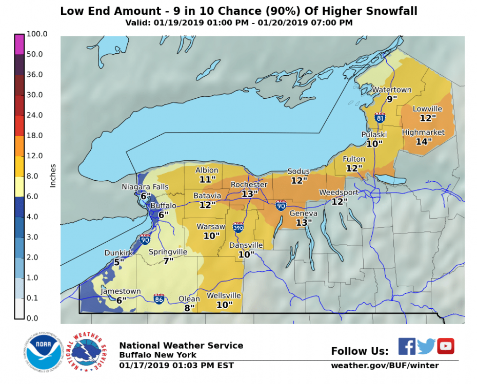
Buffalo's probabilistic forecasts have improved greatly since this AM. Very bullish.
-
3
-
-
Don't shoot the messenger, but it would seem like baseline blizzard criteria would easily be met with this system for most of us. I'm not advocating for it per se, but it would be fun to see.
-
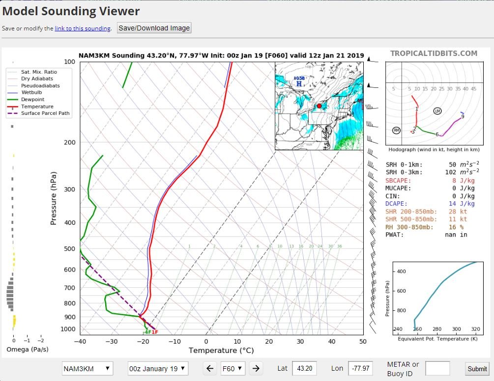
0z Nam looks the best it has been since we started tracking.....so I'll go to bed on that note.
-
26 minutes ago, Thinksnow18 said:
So is the winter storm watch awfully long in duration? Most local models have snow ending sunday afternoon and long range models do not do well with lake effect/enhancement so what would be the reason for the Sunday night and Monday time frame?
I think they would rather run it long and just cancel it once the lake dies down rather than have to extend it. And as someone else stated, blowing snow will remain a concern through the afternoon and into the evening as well.
-
5 minutes ago, wolfie09 said:

That map epitomizes Toronto's uncanny ability to avoid every storm
-
4
-
-
17 minutes ago, OSUmetstud said:
Im not going to die on a hill about this but 99.99 percent of the data in the models is not from balloons. So there's no reliability issues between 12z and 18z. In fact, model verification scores would tell you that an 18z 78 hr prog should have less error than the 12z 84 hr prog from 6 hours earlier. Occasionally you will see an abrupt change at 12z or 00z because a ballon happened to catch a poorly sampled shortwave out of the arctic. The cold temps and paralax error in the arctic make mid level shortwaves difficult to "see" via remote sensing from goes satellite.
Good post. I was just going on the answer I was told many years ago. The lack of balloons in off hour runs likely had much greater impact before the advent of recent models.
-
11 minutes ago, rochesterdave said:
Why are 6/18z models less reliable? Lower resolution? Less data input? I’ve always heard less reliable but I never know why?
No weather balloons is the big one right out of the gates. Upper atmosphere isnt sampled well.
-
1
-
-
I take it back, I just compared the wrong images.... too many tabs open
-
Just now, rochesterdave said:
So that’s an improvement. No?
There are some subtle things about the presentation of that sfc low on 18z that definitely make it better. I mean its nothing spectacular, its just in the right direction. That said, its the 18z...


Upstate/Eastern New York
in Upstate New York/Pennsylvania
Posted
We shall see. Even if it does, i don't think we accumulate more than 2 inches from noon sunday through noon Monday even if it "snows" the whole time. That backend grit won't be much but it will keep roads slick and that wintry feel in the air so that will be nice.
I hope I'm wrong and extreme temps can overcome the obscenely dry air, but I'm doubtful.