
CryHavoc
-
Posts
255 -
Joined
-
Last visited
Content Type
Profiles
Blogs
Forums
American Weather
Media Demo
Store
Gallery
Posts posted by CryHavoc
-
-
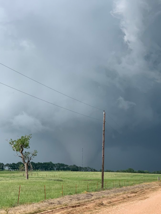
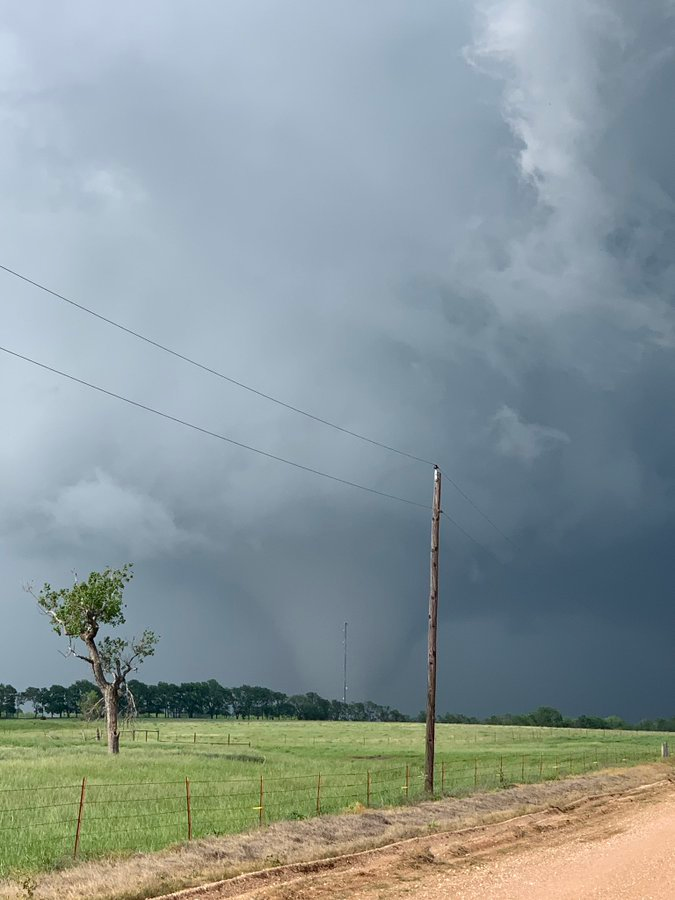
LARGE funnel cloud on stream on abc3340.com/watch
Looks like it could be OTG anytime now. -
Just now, SmokeEater said:
Huge wedge on the storm north of Coffeeville.
Sent from my SM-G973U using Tapatalk
Is there a stream?
-

When the weather program has had a few too many drinks...
-
 1
1
-
 7
7
-
-
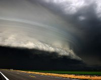
My goodness that hook on the storm near Manila/Brantley....
-
A large number of cars on John Humphress stream are driving directly toward a tornado that's on the ground. Insanity.
-
Met for WSFA just stated that he expects long track violent tornadoes in Alabama in the next 1-3 hours.
-
https://www.severestudios.com/storm-chasers/john.humphress.html
John has a seriously nasty looking storm on his livestream atm. -
First round of storms shifting into Alabama. Looks like a really bad situation.
-
6 minutes ago, tiger_deF said:
So far is this busting above, below, or right around what was forecast? I have a great deal of family in GA anxiously watching these developments and any insight would be very helpful
I don't know what would be considered "above" a high risk with 45% tor contours. It's very close to the highest risk possible that they could issue. So far that call seems to be dead on accurate, this looks like a major outbreak of tornadoes, possibly the largest in many years.
FYI be careful with the word "bust", that generally means a storm system falls way short of expectations.
-
3
-
-
Very intense storm about to track through Birmingham, AL.
-
Clinton OK now reporting 78 degrees. Dew points in the mid 60s. Could be a decent day for sig svr.
-
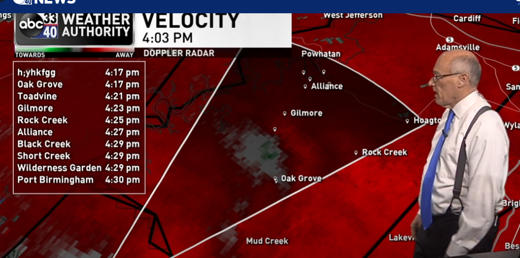
Is anyone seeing rotation on the cell SW of Talala? Looks like a fairly potent storm on reflectivity and looks decent on velocity as well.
-
-
3 minutes ago, Jackstraw said:
Massive hook on radar on that storm
Very decent rotation heading toward Stringtown as well.
-
Four separate tornado warnings across Oklahoma right now. Pretty solid day for the lack of chatter it's getting.
-
Confirmed large tornado on the ground -- Madill may have taken a direct impact.
-
Not for the 23, but there is a very nasty cell with a hook to the NW of Elk City atm. Rotation evident on velocity.
-
TOG for Texas near west columbia.
-
Tornado Warning for... West central Brazoria County in southeastern Texas... Northeastern Matagorda County in southeastern Texas...Until 2:30 PM CDT
VERY clear hook echo on this cell. -
Tornado warning for just south of Natchitoches, LA.
-
...SUMMARY...
   An outbreak of tornadoes and severe thunderstorms is expected today
   from parts of the lower Mississippi Valley across much of the the
   Southeast. In addition to tornadoes, many of the storms will have
   very large hail and wind damage. The severe threat will be greatest
   from north-central Louisiana eastward to southern and central
   Mississippi, southern and central Alabama into south-central
   Georgia. Additional severe storms with a threat for tornadoes, wind
   damage and hail will be possible in parts of east Texas this morning
   and in the Carolinas tonight.


Seems like the strongest wording possible that wouldn't include a high risk for 4/19.
-
1 minute ago, StormChaser4Life said:
Twitter is entertaining tonight. Apparently BMX talked SPC out of issuing the high risk. Can't confirm anything. Rumor mill a spinning hard tonight. Lol
I just don't get it.
If we see 60+ tornadoes tomorrow, it's going to be two undersold predictions in a row, all in the name of trying to be careful. -
1 minute ago, jojo762 said:
Just seems silly given the uncertainties with regard to convective evolution and storm mode. Tornadoes WILL happen, but there’s not a well defined corridor imo where the conditional probability would warrant a 30% sig-tor contour.
Seems like it would be issued as a result of recency bias due to last Sunday.
Yeah. I'm not trying to advocate for a HGH risk tomorrow, especially since the setup doesn't look as promising as last week.
However... all that said...I think NWS is significantly too conservative in much of their predictions. A lot of people died last week who were out of the MDT risk area. I sincerely believe we are still years if not decades away from understanding the underlying synoptic conditions that make one event a bust and another an outbreak. As someone who's spent much of his career attempting to protect people from harm, they take the under on a given day far too often. I understand there's no easy solution here with respect to being a service who cries "wolf" too often, but it's my sincere belief that giving space to the best possible setup is far more important than trying to play it safe for fear of casting out a high risk on a bust day.
-
1 minute ago, jojo762 said:
Good lord, again? Can’t wait to see all the pissed off people when/if they don’t go high risk. Wx twitter has been a disaster lately.
edit: allegedly was stated on the NWS chat, but nobody has actually verified this...
I mean.... high risk would have absolutely verified last week....
-
1
-
March 17-18 Severe Weather Event
in Southeastern States
Posted
LARGE tornado on the ground on Joseph Pisani's stream in Jemison AL.
https://livestormchasing.com/map