stormtracker
-
Posts
64,383 -
Joined
-
Last visited
Content Type
Profiles
Blogs
Forums
American Weather
Media Demo
Store
Gallery
Everything posted by stormtracker
-
I do too, but I'm way more conservative in trying to call things..so I like to wait
-
I can almost feel the anxiety and sweat from you all right now.
-
I got nothing notable to say. GFS nearly identical through 66hr
-
Tread lightly
-
-
In a normal year, maybe. This year? For me, lock in time is 84 hours or less
-
Yup. For me, the Euro did what it needed to do...lend some credence to the GFS and the idea of a storm in the area.
-
Shut the fuck up
-
It’s yours buddy. Sorry.
-
At a work thingy. Won’t be able to pbp until 18z. Hopefully I’ll get a break for the euro. It’s good vibes today. Seems to usually be the case when Ji misses a cycle. Coincidence.
-
This is what is tempering any enthusiasm whatsoever from me. Show me more guidance with this or even close to it then I’m there. But now, it’s fun and exciting to see, but eh
-

-
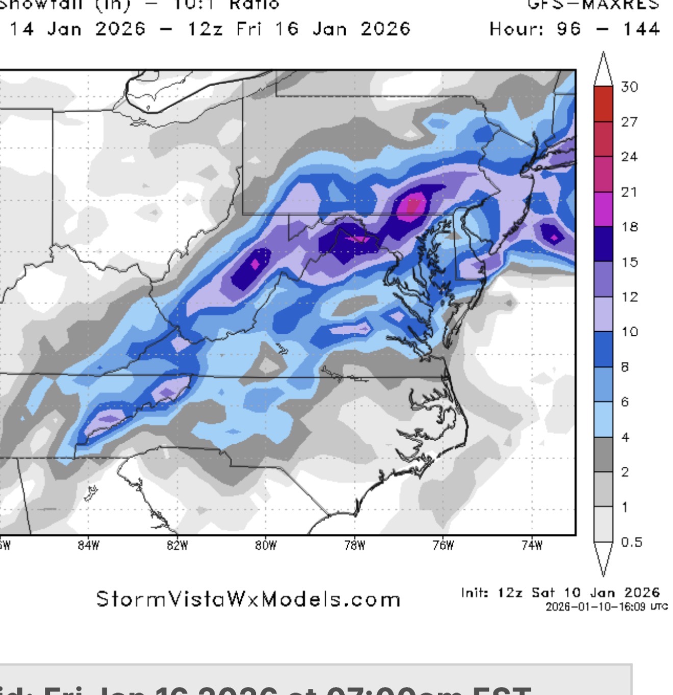
It’s an area wide shellacking.
-
lol. Snow maps. It’s too warm on the plain. At first. Hahahaha. But we do get accumulations. And it’s pretty good. Just more n and w
-
Yeah. I peeked. It’s doing a thing. Waiting to see full impact
-
Lead us on. I’m at a work thing and I’m not doing pbp on this damn phone.
-
Wanna believe that would be good extrapolated, but I mean....2026. Mid Atlantic
-
But can already tell, Euro is a whole lot of nothing. For both.
-
wtf is up with these skipping panels on the models lately. SV is particularly bad with the GFS. goes from like 210 to 252
-
AH, you show up for the bad stuff
-
Just do like most of us do...look to the left, see the avatar and just scroll past accordingly
-
Yeah, I'd take this trade off. Hope the weenies aren't mad that it's going to be totally different by tomorrow this time.
-
Not seeing it
-
Yeah, capetown storm is gonna be a dud on this run.
-
I'd be fine with that. Nice storm, closer time frame. SOLD