
stormtracker
-
Posts
64,402 -
Joined
-
Last visited
Content Type
Profiles
Blogs
Forums
American Weather
Media Demo
Store
Gallery
Everything posted by stormtracker
-

Jan 15-16 Storm Threat Thread: The Return of Hope??
stormtracker replied to stormtracker's topic in Mid Atlantic
Precip extent is wider. going from SW to NE..still light/mod at 60 -
Jan 15-16 Storm Threat Thread: The Return of Hope??
stormtracker replied to stormtracker's topic in Mid Atlantic
Nice solid area of precip over the area at 51 hours...light/mod -
Jan 15-16 Storm Threat Thread: The Return of Hope??
stormtracker replied to stormtracker's topic in Mid Atlantic
H5 appears to be slightly better than 18z so far. Not sure how that translates to the surface/precip -
Jan 15-16 Storm Threat Thread: The Return of Hope??
stormtracker replied to stormtracker's topic in Mid Atlantic
Little heavier snow at 48...not heavy...just heavier. I just can't make out if it's gonna be better yet, so I'll wait -
Jan 15-16 Storm Threat Thread: The Return of Hope??
stormtracker replied to stormtracker's topic in Mid Atlantic
Yup. I have nothing until 21z -
Jan 15-16 Storm Threat Thread: The Return of Hope??
stormtracker replied to stormtracker's topic in Mid Atlantic
Snow enters the area at 21z...heights are a tad higher out front...lets see if it's a positive or net hold -
Jan 15-16 Storm Threat Thread: The Return of Hope??
stormtracker replied to stormtracker's topic in Mid Atlantic
Interesting. SV has zip for that time -
Jan 15-16 Storm Threat Thread: The Return of Hope??
stormtracker replied to stormtracker's topic in Mid Atlantic
It's not terrible -
Jan 15-16 Storm Threat Thread: The Return of Hope??
stormtracker replied to stormtracker's topic in Mid Atlantic
So far, 0z NAM is a bit flatter out front. Sigh -
Jan 15-16 Storm Threat Thread: The Return of Hope??
stormtracker replied to stormtracker's topic in Mid Atlantic
I think our upside is 3"? I mean, it's not what we wanted, but I'd take 1-3 -
Jan Medium/Long Range Disco 2: Total Obliteration is Coming
stormtracker replied to Jebman's topic in Mid Atlantic
lil cute 1 to 2" if the GFS is to be believed. We only lost like what? 10" of snow from one run to the next -
Jan Medium/Long Range Disco 2: Total Obliteration is Coming
stormtracker replied to Jebman's topic in Mid Atlantic
Some festive light snow at hours 138-144 -
Jan Medium/Long Range Disco 2: Total Obliteration is Coming
stormtracker replied to Jebman's topic in Mid Atlantic
Oh well. Nothing like 12z. This run is a dead ratter. We got time -
Jan Medium/Long Range Disco 2: Total Obliteration is Coming
stormtracker replied to Jebman's topic in Mid Atlantic
Big differences in the west now....likely not positive -
Jan Medium/Long Range Disco 2: Total Obliteration is Coming
stormtracker replied to Jebman's topic in Mid Atlantic
DIfferences out west so far, our s/w is further west than 12z so far -
Jan Medium/Long Range Disco 2: Total Obliteration is Coming
stormtracker replied to Jebman's topic in Mid Atlantic
Now on to this Friday thang....still out of range on the GFS... -
Jan 15-16 Storm Threat Thread: The Return of Hope??
stormtracker replied to stormtracker's topic in Mid Atlantic
-
Jan 15-16 Storm Threat Thread: The Return of Hope??
stormtracker replied to stormtracker's topic in Mid Atlantic
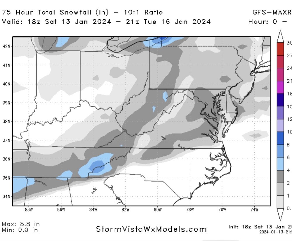
2 to 4 most of the area -
Jan 15-16 Storm Threat Thread: The Return of Hope??
stormtracker replied to stormtracker's topic in Mid Atlantic
Light stuff at 72, about to pull away -
Jan 15-16 Storm Threat Thread: The Return of Hope??
stormtracker replied to stormtracker's topic in Mid Atlantic
Still some light stuff at 69 -
Jan 15-16 Storm Threat Thread: The Return of Hope??
stormtracker replied to stormtracker's topic in Mid Atlantic
Heavier precip 63 and 66 over DC and then expands just a bit over the Central of the forum -
Jan 15-16 Storm Threat Thread: The Return of Hope??
stormtracker replied to stormtracker's topic in Mid Atlantic
There are some slight and I mean slight changes in the middle of the country..tiny bit more height rise. out in front...and I'm me just an ass hair tiny -
Jan 15-16 Storm Threat Thread: The Return of Hope??
stormtracker replied to stormtracker's topic in Mid Atlantic
no notable changes through 39hr -
Jan 15-16 Storm Threat Thread: The Return of Hope??
stormtracker replied to stormtracker's topic in Mid Atlantic
Let's see if the GFS bites... -
Jan Medium/Long Range Disco 2: Total Obliteration is Coming
stormtracker replied to Jebman's topic in Mid Atlantic
Let's hope GFS is leading the way. Because Euro is a meh with flurries