
stormtracker
-
Posts
64,402 -
Joined
-
Last visited
Content Type
Profiles
Blogs
Forums
American Weather
Media Demo
Store
Gallery
Everything posted by stormtracker
-

Jan Medium/Long Range Disco 2: Total Obliteration is Coming
stormtracker replied to Jebman's topic in Mid Atlantic
Def some coast enhancement tho from 126-132 -
Jan Medium/Long Range Disco 2: Total Obliteration is Coming
stormtracker replied to Jebman's topic in Mid Atlantic
Low develops on NC coast but goes NE away from the area.. -
Jan Medium/Long Range Disco 2: Total Obliteration is Coming
stormtracker replied to Jebman's topic in Mid Atlantic
snow still going at 18z Friday -
Jan Medium/Long Range Disco 2: Total Obliteration is Coming
stormtracker replied to Jebman's topic in Mid Atlantic
not bad, but not as good as 6z -
Jan Medium/Long Range Disco 2: Total Obliteration is Coming
stormtracker replied to Jebman's topic in Mid Atlantic
precip over the area at 12z Friday. -
Jan Medium/Long Range Disco 2: Total Obliteration is Coming
stormtracker replied to Jebman's topic in Mid Atlantic
There are differences in the nrn stream...s/w seems stretched further west/back -
Jan Medium/Long Range Disco 2: Total Obliteration is Coming
stormtracker replied to Jebman's topic in Mid Atlantic
I can't characterize it yet. I'm gonna wait and see what the nrn stream does -
Jan Medium/Long Range Disco 2: Total Obliteration is Coming
stormtracker replied to Jebman's topic in Mid Atlantic
I forgot this is nrn stream dominant so the s/w back west isn't the focus. Anyway, the egg thingy up north over eastern Canada is less pressing. You can't get this kinda analysis anywhere else folks -
Jan Medium/Long Range Disco 2: Total Obliteration is Coming
stormtracker replied to Jebman's topic in Mid Atlantic
on the gfs, s/w out west is less diggy -
Jan 15-16 Storm Threat Thread: The Return of Hope??
stormtracker replied to stormtracker's topic in Mid Atlantic
Ok bailing over to the LR thread to shit up that one with pbp for our next blizzard on the 19/20 -
Jan 15-16 Storm Threat Thread: The Return of Hope??
stormtracker replied to stormtracker's topic in Mid Atlantic
-
Jan 15-16 Storm Threat Thread: The Return of Hope??
stormtracker replied to stormtracker's topic in Mid Atlantic
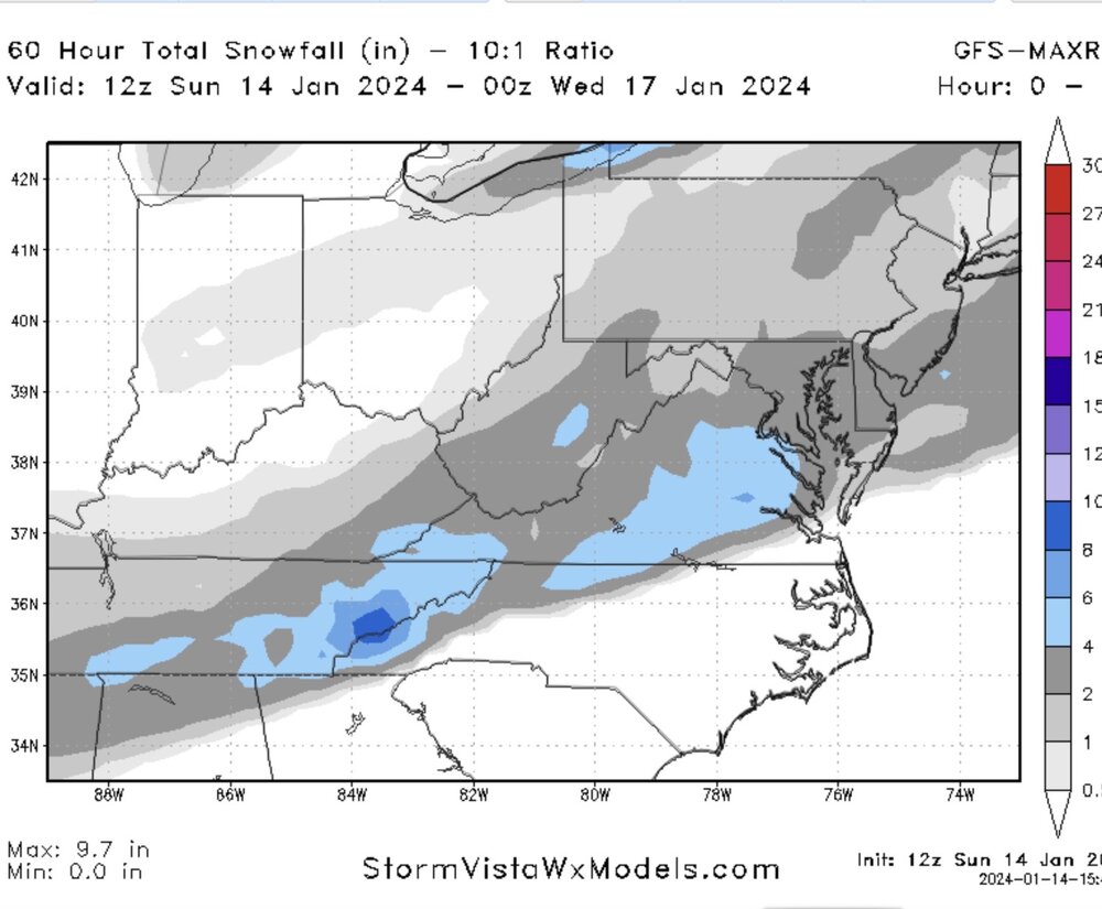
area wide 2-4, with 4 to 6 over Northern neck area -
Jan 15-16 Storm Threat Thread: The Return of Hope??
stormtracker replied to stormtracker's topic in Mid Atlantic
Done at 21z -
Jan 15-16 Storm Threat Thread: The Return of Hope??
stormtracker replied to stormtracker's topic in Mid Atlantic
still going at 51, back to light. 850s are fine...freezing is S and E of DC by like 15 miles -
Jan 15-16 Storm Threat Thread: The Return of Hope??
stormtracker replied to stormtracker's topic in Mid Atlantic
Moderate for all at 48 -
Jan 15-16 Storm Threat Thread: The Return of Hope??
stormtracker replied to stormtracker's topic in Mid Atlantic
still going at 45, lighter snow vs 6z. And then the next panel comes out and we're back on heavier returns...not HEAVY, but you know..heavier. Less aerial coverage tho of the heavier stuff. DC is under it, but mt psu is lighter rn than 6z -
Jan 15-16 Storm Threat Thread: The Return of Hope??
stormtracker replied to stormtracker's topic in Mid Atlantic
A little moderate stuff just south of DC so far. Temps are good -
Jan 15-16 Storm Threat Thread: The Return of Hope??
stormtracker replied to stormtracker's topic in Mid Atlantic
starting now at 9z and continues -
Jan 15-16 Storm Threat Thread: The Return of Hope??
stormtracker replied to stormtracker's topic in Mid Atlantic
lol, snow begins around 4am tomorrow. Last run it started a little later and there was a break at like 10 am -
Jan 15-16 Storm Threat Thread: The Return of Hope??
stormtracker replied to stormtracker's topic in Mid Atlantic
GFS a tick with higher heights in front at H5 @27hr -
Jan 15-16 Storm Threat Thread: The Return of Hope??
stormtracker replied to stormtracker's topic in Mid Atlantic
Yeah, it's a slight worry creeping in. It can't ever be simple for us! It's still gonna snow so I'm ok -
Jan 15-16 Storm Threat Thread: The Return of Hope??
stormtracker replied to stormtracker's topic in Mid Atlantic
Per NAM, starts at like 4pm tomm and wraps up around 5pm Tuesday -
Jan 15-16 Storm Threat Thread: The Return of Hope??
stormtracker replied to stormtracker's topic in Mid Atlantic
yeah, was right..NW areas heaviest. Surprise Surprise. I mean, I'd still take it in a heartbeat. -
Jan 15-16 Storm Threat Thread: The Return of Hope??
stormtracker replied to stormtracker's topic in Mid Atlantic
Back edge at 21z. Somebody else post the purty snow maps -
Jan 15-16 Storm Threat Thread: The Return of Hope??
stormtracker replied to stormtracker's topic in Mid Atlantic
Outcome would seem to favor NW in terms of heaviest snow. We'll see.