

Master of Disaster
-
Posts
1,386 -
Joined
-
Last visited
Content Type
Profiles
Blogs
Forums
American Weather
Media Demo
Store
Gallery
Posts posted by Master of Disaster
-
-
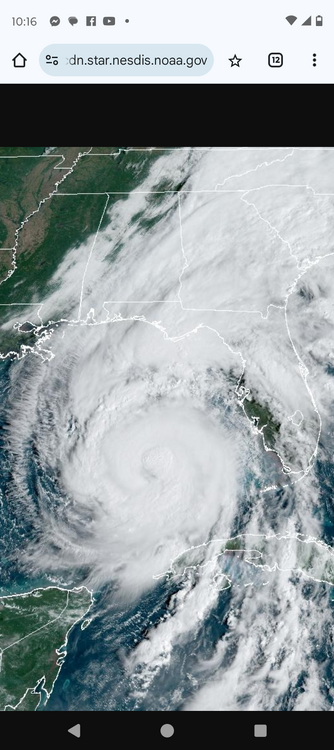
Not much larger than TS Marco. This may be one of the smallest hurricanes on record now. I seem to recall Marco having TS winds 11 miles from the center.
-
 1
1
-
 1
1
-
-
12 minutes ago, ice1972 said:
lol double it.....its just not TECO.....statewide its at 2 million if not more......
Agreed if it's that many. I was running off the 400K number.
-
While we wait for the next recon. Where are you guys getting these eye lightning strike images and videos from?
-
1 minute ago, NJwx85 said:
Tropical systems are categorized by maximum sustained winds, not surface pressure.
The least intense Cat 5 was 943mb. Hurricane Francine in 1971 for reference.
-
1
-
-
What was the hour count from TS to Cat 5? Like 36 hours?
-
Just now, csnavywx said:
It's basically out of time here, but if this were still well out over water, then this is the kind of setup that could eventually result in an EWRC. The series of mesovort formations and mergers we've been getting usually precedes cocentric band formation -- so you could argue we're getting ready to enter the incipient phase of one.
What's nice is satellite technology has advanced to the point we can observe the entire sequence.
-
2
-
-
1 minute ago, DDweatherman said:
I would call what happened last night a pseudo ERC. The eyeball started as nascent than made its way through the stages and in doing so there was the reorganization of the core & CDO. Not the true ERC’s we see with more developed, substantial canes.
Fair statement. A half assed ERC.
-
2
-
-
29 minutes ago, BTRWx's Thanks Giving said:
Could it be going through an eyewall replacement cycle?
Not likely considering it has one last night.
-
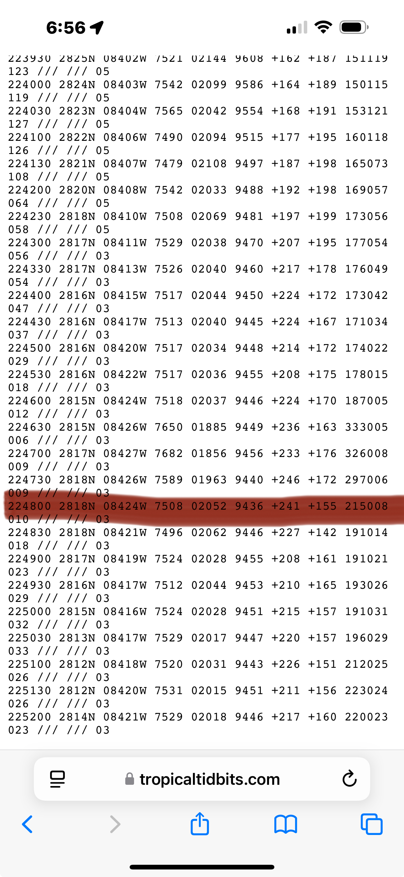
New pressure 942.5mb
-
13 minutes ago, AccuChris said:
943mb just recorded about 10 mins ago on recons last pass through the eye
.
943 is the intensity of a Cat 5 hurricane in 1971.
-
1
-
-
1 minute ago, wthrmn654 said:
We may of lost the buoy...
That does happen. I use to set those in the Coast Guard. They snap their chain mooring. I have pulled them off the beach and everything.
-
5
-
-
2 minutes ago, Eskimo Joe said:
This has got to be a Cat 4 now.
Almost certainly is
-
3 minutes ago, WxSynopsisDavid said:
Mind you, this Rapid Intensification process was friction induced. People often forget about the critical angle of approach and how the Florida west coast often induces frictional RI processes on approach.
The NHC guys call this a Kelvin Wave.
-
2
-
-
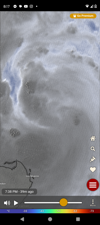
Lightning popping around the eyewall for the first time.

-
1
-
-
2 minutes ago, OSUmetstud said:
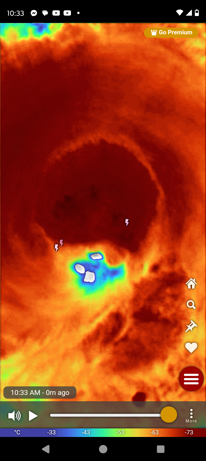
It's elliptical and open sw now, but pretty large eye overall.
F. OPEN SW
G. E13/38/22
Now that you point it out you can see the open area at the SW. Didn't even notice till you said that.
-
Is that eye 32 miles across? Did I read that correctly?
-
9 minutes ago, user13 said:
f I'm surprised they kept the due N peg. It does look like it's ticking east
That's pretty much Mexico Beach from Michael.
-
How warm is the water ahead of this? I had a site years ago to find this but can't remember what it was.
-
@stormtrackerare you chasing this or headed down for another reason?
-
2 minutes ago, Nibor said:

This might be better at illustrating your question.
That's even better.
-
1 minute ago, andyhb said:
This picture tells me literally nothing.
Thank you. Kinda like your reply then? It was a question. Like is that what it is?
-
2
-
-
I kinda wonder if those are hot towers beginning to fire around the center.
-
2
-
-
Years ago, I was chatting with one of the NHC guys and he mentioned that hurricanes on this approach produce a Kelvin Wave. The energy from the storm refracts back and forth from the coast to the hurricane until finally it crashes into Appalachcola Bay. There was one storm. I wanna say it was Ivan that produced this effect and that Bay saw a significant storm surge but was well outside the threat zone.
-
1
-
-
4 minutes ago, Normandy said:
Alright gentlemen it’s that time. Let’s make our calls for what recon finds. I’m going with:
winds: 144 kts flight level
Pressure: 929 mbs
24mb in an hour?
-
2
-


January 5-6 Thing II: STORM MODE
in Mid Atlantic
Posted
Did some research this morning. The last plowable snowfall event of 4 to 8 inches for DMV was Jan 3rd 2022. They are well overdue for a good storm.