

beavis1729
-
Posts
2,429 -
Joined
-
Last visited
Content Type
Profiles
Blogs
Forums
American Weather
Media Demo
Store
Gallery
Posts posted by beavis1729
-
-
45 minutes ago, Younar said:
This is my fifth winter living in MSP and I can now officially say MSP is a snow lover’s hell. Don’t move her if you like snow. Everything either goes north, south, east or west of here. I was hoping this upcoming pattern would get the clipper train going for us... nope. Congrats FSD and ORD. You would have a better chance playing pick up sticks with your butt cheeks than finding a good snowstorm here.*
*April 2017 excluded
I hear your frustration. Look up January 1982 and the Winters of 1995-96 and 1996-97...I believe those were some good times for snow in MSP. Also, the extreme cold in Feb 1996.
-
2 minutes ago, nrgjeff said:
Both sets of Ensembles keep the 11-15 day colder than normal. GFS/FV3 may have both been bad runs. Perhaps a bird farted near a jet taking samples over the Pacific.
Ha...and of course there will be fluctuations on op runs that far out.
I am talking about extreme cold, not just modestly below normal. Hopefully that comes back. A couple days ago, there was an EPS ensemble map showing Day 11-15 mean temp departures of -15 to -20 C, or about -27 to -36 F, for the time period you mentioned, in addition to the handful of FV3 runs showing -40s F or colder in southern Canada.
-
 1
1
-
-
5 hours ago, nrgjeff said:
ECWMF does seem to want to dig the weekend system a little longer, which would put West Tenn and of course Kentucky in play for snow. Couple storms this year the ECWMF beat the NAM in short range (30-36 hr) in the Midwest. Will it translate South?
MJO wants influence later next week, but I tend to believe the strong blocking signals will outweigh. Looks like a mild interlude between arctic systems is likely. It might be 1-2 days. A West first arctic dump might give us 3-4 mild days. Still from the upper latitudes pattern I infer it comes east. Pretty safe call really. Still looks like a true arctic outbreak Jan 26-30.
Very end of the EPS has it easing up slightly, but one expects some ebb and flow. I expect more cold in Feb.
I was thinking the same thing too, based on the FV3 and the EPS runs over the past few days. Then, today's 12z FV3 lost the arctic outbreak completely. Could the MJO really be the culprit, again? It was only one op run, so we'll see what happens.
-
Well, the arctic outbreak disappeared on the 12z FV3. You just gotta laugh. Sure, it was 11-14 days out, but it was also showing up strongly on EPS ensembles over the past few days. It looks like the PV doesn't come as far south as modeled before...and it also goes more into New England instead of the Midwest.
I guess it may come back...but, in the meantime, what happened??
-
28 minutes ago, Angrysummons said:
I would put this energy vortex right up against Super Bowl, GHD and the 1999 storms in terms of Great Lakes snowfall/wind potential. You just look at that vortex off the pacific your like wow!!!! What a high priced texas hooker.

Did someone steal your keyboard?

-
 2
2
-
-
25 minutes ago, Chicago Storm said:
For those on the north end of the storm looking for a bump north, those looking for a cutter, or the historic-like 0z ECMWF run to occur...
The one big negative I see that I didn't see before is that the main PV over the Hudson actually gets dragged east by a big storm around Greenland...just as the northern stream wave is diving south around the PV...which pulls the wave more the the east as well. One of the big reasons I believe the 0z ECMWF was a huge run is that the northern wave was faster and the PV was centered further west early on. This combination allowed the northern wave to dig more before sliding more easterly, allowing for some phasing earlier.
Placement of the southern wave is key as well. There is good agreement on it coming onshore in N. CA and diving SE, with the base of the trough down into El Paso eventually. After that what is needed is key timing, as well as the wave closing off further north. The 0z ECMWF also had this occur and what was aforementioned with the northern wave, which helped lead to the big run.
The lead minor wave on Wed/Thur will be fully sampled for this evenings runs. The south and northern wave will be well sampled by Thur evenings runs, and even more so after.
Good points.
I wonder if a decent # of the 12z Euro ensemble members had positive developments in this regard, given that the ensemble mean was a bit NW of the op.
-

Definitely some amazing numbers showing up over the past few days of model runs. Would like to get this within 10 days before getting too excited, instead of the current 12-14 days.
Assuming things continue trending this way, I would be ecstatic with a -20 at ORD. I don’t believe this has happened since January 1994. February 1996 and January 2009 came close...and many other nearby areas including RFD did hit -20 during those outbreaks. And, of course, the arctic tundra day of 1/6/2014. -14 at noon local time with wind chills in the -40s and a deep snowpack, but the winds never died down and the skies never cleared...so we only bottomed at -17 IMBY.
At least there are 2 things that are favorable, as it looks now: expected snow cover in N IL and significant cold in southern Canada. Would like to see some snowcover in WI to reduce any possible modification of the airmass, and need to get this within 10 days on most/all of the models. Once that happens, a thread will be coming.
")
Thoughts?
-
1
-
-
52 minutes ago, Chicago Storm said:
ECMWF, like the GfS, with another big dog for the following system.
24”+ across the Chicago area.
.FWIW...over the past few days, HM has been harping on a pattern that could be conducive to a Midwest blizzard around this timeframe. Still way out there, but will be curious to see his thoughts.
-
Wow, amazing modeled cold. Hard to comprehend.
Someone posted the EPS in the mid Atlantic forum...at day 15, departures of -15C to -20C were centered over our area.
And good to hear about the weeklies.
-
26 minutes ago, Carvers Gap said:
FWIW, the 18z snow mean looks pretty good for most of the forum as well.
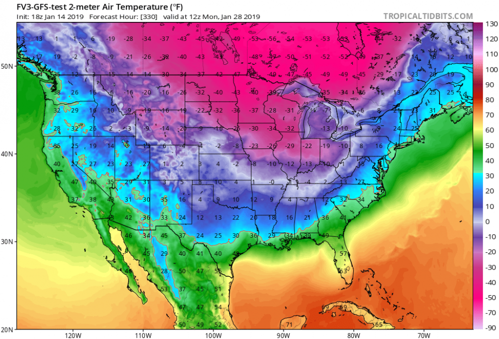
Another fun run, take a look at the 18z FV3 temps in southern Canada near the end of that run. I saw -56F. Wonder how long it will be until the Polar Vortex starts making headlines?
Yeah...FWIW, the incredible 462 dm thickness contour made an appearance at hour 306. It's very rare to see even 474 dm...and 468 dm is almost unheard of. 462 dm almost seems impossible. Sure, it's Day 13 on one run of an operational model...but this is noteworthy simply because, over the past 25 years of winter observing, I have never seen 462.
Good times...and nice discussion in here too!
-
4
-
 1
1
-
-
4 hours ago, IWXwx said:
That is save worthy though.
Yeah, definitely...and then the 18z FV3 outdoes it somehow, at least for the upper midwest. There is a 462 dm thickness contour in southern Canada at hours 306 and 318. To put this in perspective: you very rarely see 474 thicknesses...and I may have seen a 468 once in the past 10-15 years...but I can't ever remember seeing 462. This is shocking cold...even for a model prog 13 days out.
Here is another image for the archives. -56 in Ontario and -49 just north of the MN arrowhead.
-
1
-
-
FWIW, the 12z FV3 is going crazy again with an arctic outbreak toward the end of January.
Besides the fact that it's 12-16 days out, and has been pushed back in time a bit relative to a few days ago...there is tremendous cold sitting in southern Canada that could be tapped eventually. Ideally, we would need a strong storm tracking NNE through the GL/OV and/or a potent clipper to drag down the cold air. Hopefully it will happen at some point.
Even if the PV does come down for a visit, even I would be forced to admit that the temps shown on the FV3 are overdone.

For posterity:

-
2
-
-
19 minutes ago, mimillman said:
It’s a solid hit for a good chunk of us. Would take that and run
Agree.
And, you just get the feeling that the intense cold/PV in southern Canada is waiting to be tapped at some point. Just need a clipper and/or major storm to drag it down. Obviously it's very far out there and hasn't really moved up in time...but, verbatim, thicknesses on the 12z FV3 are sub-500 for much of the western Great Lakes for the entire Day 12-16 period.
-
1 hour ago, Chambana said:
Breathtaking photo opportunity this morning as freezing fog has stuck to the snow plastered trees. It looks amazing outside. Got down to 2 degrees.
Nice picture! Amazing what clear skies, calm wind, and limited UHI can do.
It only dropped to 25F this morning here in the NW suburbs of Chicago, with a blanket of clouds and about 3" of snow cover.
-
1 hour ago, Hoosier said:
I'm sure somebody noticed this out in weenieland. The phase is impressive enough (and check out the 28 mb drop in one 12 hour time period) and how about an 80 mb pressure gradient with the surface high in the Plains.
Wow, that’s a classic phase, pulling down the PV. Obviously a solution like that is unlikely, but the chances of it happening are greater than normal due to extreme cold lurking in S Canada and an amplified pattern.
-
13 minutes ago, hawkeye_wx said:
And now the euro has the Missouri-Ohio Valley biggie next weekend. Wash, rinse, repeat.


It would be nice to have at least a little bit of snow cover everywhere within the sub-forum and upstream of us by January 20th. 2", 4", 12", whatever. There are some signs (although never guaranteed, of course) that the PV is going to come crashing down at some point, so it would be great to maximize the cold potential.

-
9 minutes ago, nzucker said:
-50C 850s? Where? Never seen that before....usually the coldest the PV gets is like -40C.
Probably means -50 at surface...colder than 850mb temps due to snow cover/clear skies/inversion?
-
1
-
-
3 minutes ago, Hoosier said:
I am looking at that 1040 mb high just north of the Lakes and thinking it's going to make its presence felt. LOT had some good points in the overnight afd about this kind of storm track not typically bringing much snow to the area, but they also pointed out the impressive jet dynamics. Southern WI/northern IL and eastward into MI is the main potential bust area in terms of dry air. STL is looking to be in a great spot.
Unfortunately for MBY, I agree. Dewpoint at ORD is only 7F...probably the driest air so far in this joke of a "season". Will take awhile to moisten up, especially with relatively dry NE winds ahead of the storm's arrival.
-
Nuiqsut, AK (north central part of the state) was -42 at 8 PM last night, south wind at 9 mph, wind chill -67.
At least someone in North America is experiencing winter.
-
Nice discussion in here, all.
Ironically, I just mentioned January 1985 in the Lakes/OV banter thread.
Obviously grasping at straws...but does anyone think that an outcome similar to 1984-85 is remotely possible?
That winter had an unacceptably warm December in the Midwest, but then things snapped around the new year.
As an example: Chicago (ORD) only had 3.4" of snow for the season through December 30th, with a max seasonal snow depth of 1"...along with a ridiculous high/low temp of 69F/49F on 12/28/1984. Then, from December 31st through February 14th, about 35" of snow fell...and the temp dropped to -27F on 1/20/1985...still the all-time record low at ORD. From February 1st-9th, each day had a low temp of 3F or colder. This 45-day period was about 8 degrees below normal, with snow cover the entire time...maxing at 15" depth on February 14th. Then, winter ended abruptly after that.
Interesting...
-
Obviously grasping at straws here...but does anyone think that an outcome similar to 1984-85 is remotely possible?
That winter had an unacceptably warm December in the Midwest, but then things snapped around the new year.
As an example: ORD only had 3.4" of snow for the season through December 30th, with a max snow depth of 1"...along with a ridiculous high/low temp of 69F/49F on 12/28/1984. Then, from December 31st through February 14th, about 35" of snow fell...and the temp dropped to -27F on 1/20/1985...still the all-time record low at ORD. From February 1st-9th, each day had a low temp of 3F or colder. This 45-day period was about 8 degrees below normal, with snow cover the entire time...maxing at 15" depth on February 14th. Then, winter ended abruptly after that.
-
2
-
-
52 minutes ago, psuhoffman said:
Same game going on in the mid Atlantic forum. Even I'm frustrated. I still firmly believe the pattern will flip late January but that doesn't make the utter disaster it's been easier to wait through. I thought it would be warm and likely not much snow but I guess I thought we might luck our way to SOME snow here or there. It's been a complete shutout pattern for weeks on end. Yea the threads are a mess but I can understand the emotions.
And the Great Lakes/OV forum. Chicago has seen about 1-2” of total snowfall over the past 5 weeks, which will probably become 7 weeks...and parts of WI have seen less than 3” all season.
Sure, the pattern may change soon...but even if it does, it won’t save the winter...even it results in something like 3x climo snowfall from 1/15 to 2/28.
Winter is supposed to be a mood, a season, a vibe...not just “event driven”. A 2-week wintry period (assuming this even happens) is not winter. The season is 13 weeks, not 2 weeks. That is what’s driving people crazy. Where are the clippers? Windy arctic fronts? Anything resembling the feeling of winter? Where are the seasons in seasons?
Weenies across the country are upset...no one is spared. Of course you hold out hope for a dramatic flip...like in Chicago when it hit 69F on 12/29/84 and then -27F 3 weeks later on 1/20/85. But you can’t pin your hopes on that.
-
1
-
-
-
55 minutes ago, (((Will))) said:
That tends to be the case in every 'group.' It'll be necessity that makes people change and necessity is rarely about philosophical moral progress straight up, it tends to be cloaked in seemingly random variables personal to every group. Either it just hasn't been a big enough deal to Americans yet or perhaps there's still some anti british/continental streak still running through Americans. Maybe it's something altogether else. Who knows. Either way - progress for the good of the world is rarely so simple. Altruism is almost never really altruistic.
Yep. Unfortunately, I agree with you.


Winter Storm? Jan 18-19th, 2019
in Lakes/Ohio Valley
Posted
Yeah, seems like the surface lows are generally similar in strength and location on the 12z GFS and 12z NAM...but for Chicago area, GFS shows about 0.4” of liquid and NAM is close to 1”. Splitting the difference is probably a reasonable approach for now. 0.7” of liquid at 13:1 ratios implies about 9” of snow. Admittedly it’s a very rough estimate, but we will see what other hi res guidance starts showing as it gets into better range.
Either way, lake effect/enhancement will be an interesting wildcard.