

beavis1729
-
Posts
2,429 -
Joined
-
Last visited
Content Type
Profiles
Blogs
Forums
American Weather
Media Demo
Store
Gallery
Posts posted by beavis1729
-
-
8 minutes ago, Chicago Storm said:
Kind of the opposite I thought would happen given 12z guidance trends, is for the 12z ECMWF to come a bit north.
.Agree, has been confounding to say the least.
-
47 minutes ago, Hoosier said:
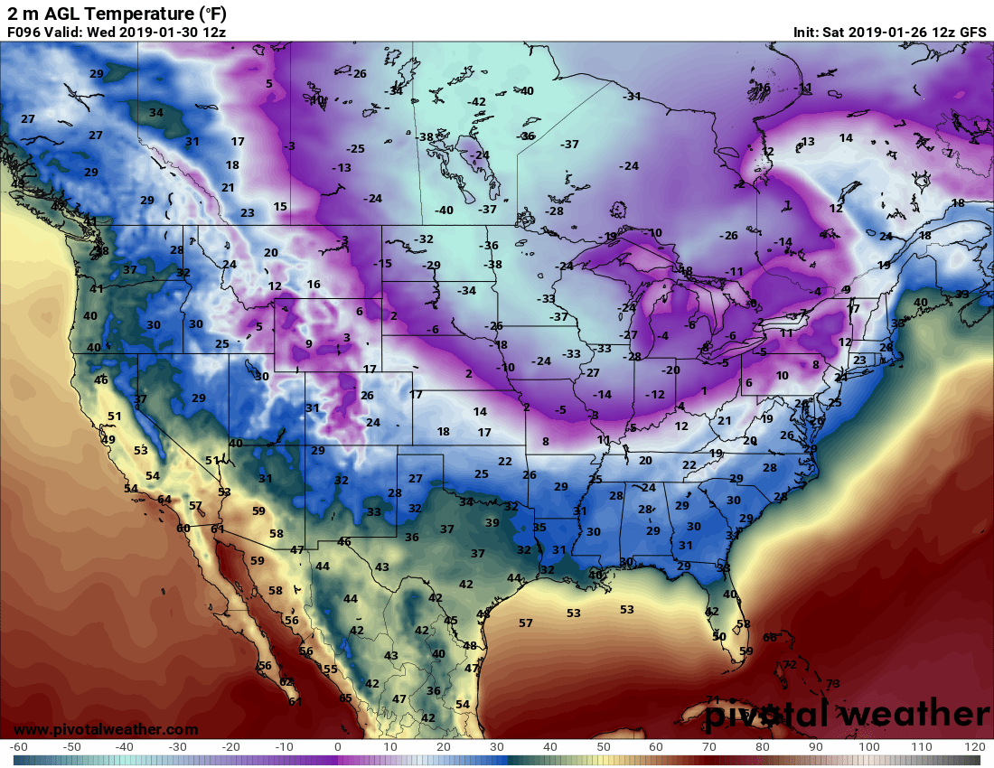
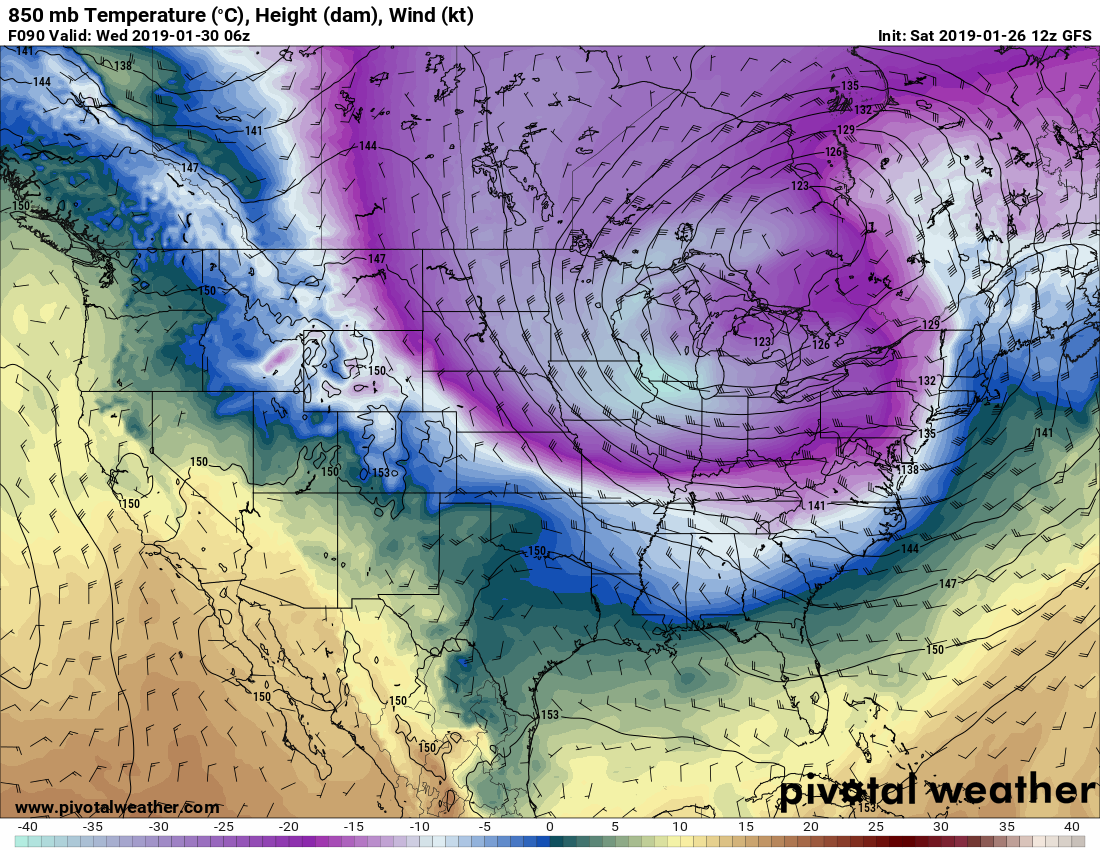
The FV3 is still like a coldpocalypse. Has about -37 at ORD on Wednesday.
Crazy. Will be fun to see the HRRR temps over the next couple of days.
-
8 hours ago, Hoosier said:
00z Euro has a spot of -38C 850 mb temps on the IL/WI border at 12z Wednesday.
Will be curious to see which model's 2m temp progs do best with this.
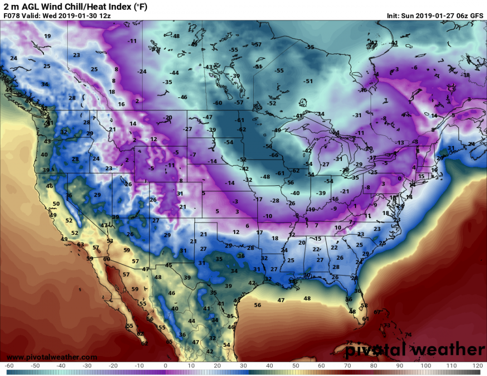
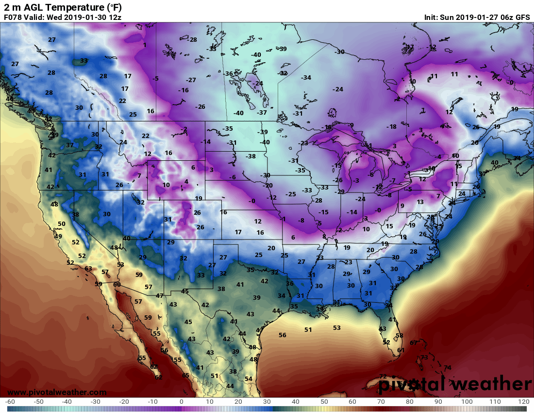
And the 06z GFS shows -37C in the same area. Pretty amazing. It seems pretty certain that -35C H85 temps or colder will occur in parts of IL. If so, you'd have to think that LOT's forecast lows could be a bit conservative on Wed morning (generally -20 to -23)...but of course it makes sense to go conservative for now, then they can always bring temps down a bit over the next 12-24 hours if the models hold on to this.
Unfortunately, it looks like the core of the coldest air moves out quickly. I now think that Wed morning will probably have both the coldest temps and the strongest winds in the Chicago area. Rural areas of N IL may be different. The radiational cooling on Thu morning may be better, but H85 temps will have warmed significantly by then...to around -25C. Will be interesting to see how this plays out.
-
Verbatim, this would break the all-time record low wind chill in IA and IL...although it's probably overdone a bit.
-
-
INL hit -46 this morning...wow.
-
23 minutes ago, Geoboy645 said:
Quick someone find that record windchills thread from the middle of last summer.

Who knew it would eventually be so handy.
-
 1
1
-
-
Record coldest wind chills by state on the new scale, as best I can tell:
MN: -66 at Duluth, 1/10/1982
IA: -64 at Waterloo, 12/24/1983
WI: -59 at Eau Claire, 1/10/1982
IL: -60 at Chicago, 1/20/1985
-
53 minutes ago, BombsAway1288 said:
Wow, I didn't realize it was like that.I know there is a big difference between Rockford and Chicago when it comes to arctic blasts and UHI but I always assumed that Rockford wasn't part of the Chicago metro area (If that's what you guys even call it). I was just going off of general maps I've seen of the area.
BTW speaking of Rockford, did they ever confirm that super record low back in 2014? I think it was something like -30 degrees or something like that and the NWS mets couldn't believe it so they went and checked the ASOS and I think even stayed overnight observing it or something to make sure it was calibrated properly.
No, that was a different location in 2014...I think it was RPJ (Rochelle, IL). The -30 was not deemed official.
-
27 minutes ago, Hoosier said:
So keeping in mind that this situation is so rare/virtually without precedent in northern IL, I think there's a decent shot at the high not getting warmer than -15 at ORD on Wednesday. -15 would break the all-time record low max by 4 degrees.
A couple things that could interfere with that. One, the airmass modifies a bit in the coming days and it just isn't able to stay that cold during the day. The other would be the dreaded midnight high. Right now, it looks like the cold comes just quickly enough to prevent the midnight high scenario but it's something to monitor.
Agree with your thoughts. I think the midnight high is more of a risk. It looks fairly likely that temps will stay below -11 on Wednesday afternoon. We’ll see what the 0z runs show tonight.
-
Yes, ORD has significant UHI, along with all of the Chicago suburbs. An example is this morning, when ORD only hit -6 but many rural areas of northern IL were in the -10s and -20s. ORD doesn’t radiate well at all. It’s not quite as bad as NYC...but that’s not saying much...
-
Wind chills off the charts...
-
-
54 minutes ago, Geoboy645 said:
Also the records for Illinois are -36 set in 1999 at East St Louis, for Minnesota -60 set in 1996 at Tower, for Michigan -51 set in 1934 at Vanderbilt, and for Indiana -36 set in 1994 at New Whiteland and for Iowa -47 set in 1996 at Elkader. I'd say the most likely records to be broken would probably be Illinois and Iowa with a medium chance for Wisconsin and an outside shot for Minnesota and Indiana.
Good info. Unfortunately, it looks like clouds and/or wind could prevent temps from dropping as low as they otherwise could, given the airmass in place. I hope I am wrong. Still a bit too far away to pin down the details. If any locations can clear out or have lighter winds, then things could definitely get out of hand. Either way, wind chills will be extreme, possibly down to -50 in northern IL. On 1/6/2014, I believe wind chills bottomed near -45.
At this point, I would guess the following lowest temps by state: IL -30, IA -35, WI -35, MN -40.
-
If I'm reading the scale right, 12z GFS still showing H85 temps around -37C in northern IL...and it’s only 90 hours away.


-
-15 here, wow.
-
57 minutes ago, Hoosier said:
I think this even surpasses that Euro run from the other day that had -30s at 18z, as far as areal coverage. This is unthinkable... no way in hell, right?
Beavis is probably going to print this out and hang it up.


-
LOT AFD, long-term from Izzi
Tuesday through Friday...

Record breaking and potentially historic outbreak of cold still
appears to be in the offing for the middle of next week. Greater
than normal degree of forecast uncertainty in temperatures, due in
large part to models showing all time records being broken and in
some cases shattered.

Generally made only very small tweaks to the temperatures from the
model blend, due to the uncertainty. It is worth noting, that this
model blend includes bias-corrected grids which still reflect a
bias correction warmer from the unseasonable warm spell back in
late Dec and early Jan and also contains a MOS component which
tends to have some weighting toward climo, which obviously midweek
temps will not look anything like climo. Typically, in record
breaking temperature situations, a blend of the raw 2m model
temperatures verifies best and those values are colder than our
official forecast and approach or break all time records for ORD
and MDW.

The GFS, GFS-FV3, GEM, and ECMWF 12z operational runs all continue
to drop 850mb temps to below -30C & in the case of the GFS to-
40C. To put this into perspective, using the SPC sounding climo
page, the coldest 850mb temp even observed in IL (ILX, DVN, RAN,
and PIA and dates as far back as 1949). Over the past couple days
there have been some minor run to run variations in how low 850mb
temps bottom out, but there has been a good deal of consistency of
850mb at least reach -30C. Even the 51 member ECMWF ensemble has
850mb temps reaching -30C over northern IL.

Assuming we have a fresh snow pack from Monday`s system, the stage
would be set for temperatures to really get out of hand and end up
colder than currently forecast. Initially, moderate to strong
northwest winds look to send wind chills bottoming out in the -35
to -50F range late Tues night into Wednesday. Some minor
improvement in wind chills is expected Wed night into Thursday
morning, due primarily to diminishing winds. Also worth noting
that the 35 to 50 below wind chills are based on the somewhat
conservative official forecast temps, but should the colder raw 2m
model temps verify we could see wind chills approaching 60 below
in the coldest areas and with most of the CWA reaching close to 50
below.

There is still time for model guidance to back off on the
intensity of Arctic air mass. Keeping that in mind, I felt quite
comfortable with the more conservative temperature forecast. It is
much easier and preferred to slowly trend a forecast closer to
all time records this far out, rather than jumping out forecasting
all time records only to later have to back off on those extremes
if model guidance trends less severe with the cold.

To put this cold into perspective some, during the past 20 years,
Chicago has only had a sub zero high temp twice and only 22 times
in the past 100 years. Our current forecast has air temps below
zero between 40 and 60 hours across most of the CWA, which a much
longer period of sub-zero wind chills.

While still very cold, temps do look like they will begin to
moderate Friday.

- Izzi

&&

.CLIMATE...

Here are the record lows and record cold highs for next week`s
cold...

                     Tue Jan 29   Wed Jan 30   Thu Jan 31
   Chicago
Record Low           -16 (1966)   -15 (1966)   -12 (1985)
Record Low Max        -6 (1966)     3 (1966)     1 (1971)

   Rockford
Record Low -20 (1966)   -19 (1966)   -18 (1966)
Record Low Max  -9 (1966)    -3 (1951)    -3 (1996)

   Chicago
All Time Record Low:      -27 (Jan 20, 1985)
All Time Record Low Max:  -11 (Jan 18, 1994 & Dec 24, 1983)

   Rockford
All Time Record Low:      -27 (Jan 10, 1982)
All Time Record Low Max:  -14 (Jan 18, 1994 & Jan 6, 1912)

- Izzi
-
14 minutes ago, Chicago Storm said:
Good news is that even the GFS with the miss north for the hybrid storm, still has lows in the -30's and highs in the -20's on Wed.
Yeah, the 12z GFS generally held serve on the arctic outbreak, although verbatim it's a bit shorter in duration than what has been shown over the past few days. Strange outcome...because you'd think that with the Monday storm being more north, it wouldn't be able to pull the cold air down as far south as before...yet it still did.
Heck, I'll take a -12/-22 day at ORD, to set the all-time low max. You'd think Thursday 1/31 has the best chance of doing this, as it will likely not have a midnght high going into the day...but of course it could warm up later in the evening of 1/31 if the arctic air mass begins moving out. It makes 1/18/94 and 12/24/83 even more remarkable to think about, both with highs of -11.
At this point, it doesn't look like the all-time record low will be set. Of course it was always a long shot due to UHI and needing a million things to go right...but it actually looked possible over the past few days.
Still nice to see the sub-480 thicknesses on the GFS, though.
-
Just now, Baum said:
melt down watch in effect.

-
 1
1
-
-
Just now, SchaumburgStormer said:
It’s second down. No punting yet. Wait till this sucker is at least partially sampled.
Yep, fair point...but hard to deny the trends across the board.
-
6 minutes ago, HillsdaleMIWeather said:
GEM is a touch north, still most south
Right...and it means that the furthest south of all models is now tracking the low over the IL/WI state line. Not good trends for the Chicago area. In addition to missing out on the heaviest QPF axis, the ratios will be much worse, since temps won't be as cold. If trends continue, Chicago will be lucky to see 2" out of this, with temps warming into the 30s after the snowfall.
What used to be a clipper parade has now turned into essentially one meaningful clipper...and now this one clipper may not even produce...and now the arctic outbreak next week is being muted. Not a good day for winter weather lovers here. Better in MN/WI. While these shifts are not too unusual 3-6 days out (and perhaps we're guilty of getting too excited too far out), it's still frustrating.
-
 1
1
-
-
Trends are definitely concerning. I guess the good news is that this is a rather unusual system/track, and the models could be having difficulty due to the unique situation and/or poor sampling in the source area. Of course this may just be weenie thinking...but we'll see.
-
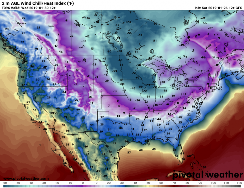
8 hours ago, Chicago Storm said:
0z ECMWF with a significant step back regarding the cold next week.
Ugh, not good. What about 0z Euro ensembles and the 6z Euro op?

Hybrid Clipper Event 1/27-1/29
in Lakes/Ohio Valley
Posted
What a strange track on the NAM. I guess the Euro is doing this too, to some extent. The storm was modeled for the last 6 days to come down from the NNW and then head due E...and now, just before the event, we get a NE hook showing up on the models.
Not saying this to complain...but this storm has been bizarre to say the least.