

beavis1729
-
Posts
2,429 -
Joined
-
Last visited
Content Type
Profiles
Blogs
Forums
American Weather
Media Demo
Store
Gallery
Posts posted by beavis1729
-
-
RAP is actually trending a bit colder. 22z RAP shows low temps of -37 at RFD and -33 at ORD.
Actual modeled temps on the RAP may be overdone, but I think the trends are important.
To Stebo’s post above, the NWS point forecast for some locations in northern MN (near INL) is down to -51.

-
5 minutes ago, Chicago Storm said:
Yea, there's a few check points I have in mind to break the record or hit -30.
20z RAP shows -21 at 9 pm and -25 at midnight, then bottoming at -32 at 7 am.
On paper, it seems like ORD has a good shot at the record. Assuming -14 at 4 pm, it needs to drop one degree per hour over the following 15 hours in order to hit -29.
-
2 pm temps:
-16 ORD
-14 RFD
-14 here
-
28 minutes ago, Hoosier said:
The lack of a bigger rise around Chicago metro is a bit interesting. Most of that area has only come up about 6 degrees from morning lows so far, not just ORD. CAA did occur through 7-8 am or so, but evidently it's been difficult to flip the switch to quicker warming.
Probably a couple reasons why ORD is colder than MLI: west winds covering less of a snow field before arriving at MLI, and H85 temps are a bit warmer at MLI.
-
44 minutes ago, BuffaloWeather said:
2-4’ of snow, winds gusting over 50 mph, temps around 0, wind chills -30s. Blizzard warnings issued, visibility is zero, going to be a all time event for Buffalo area. It’s a 1985 redux. Travel bans and state of emergencies issued. Haven’t seen a storm like this in awhile
 Wow...enjoy!
-
 1
1
-
-
ORD still -17 at 1pm central...wow.
-
Rockford had a midnight temp of -16, but it has now warmed up to -15 at 1pm central. All time record low max is -14 on 1/18/1994 and 1/6/1924...which will probably hold.
It looks like the coldest daily mean temp at Rockford is -18.5 on 1/18/1994 (high -14, low -23). That has a good chance of being broken. Just need today’s high temp to not go above -13, or it needs to drop below -25 prior to midnight.
-
We'll have to pull up the January 2014 thread to see what the coldest Chicago noon temps are. I think today's -18 at ORD may be the 2nd or 3rd coldest all-time?
-
1 minute ago, Hoosier said:
2 or 3 more hours of warming, then katy bar the door.

Wow, is ORD colder than RFD at 12 noon...you don't see that very often in an arctic air mass.
-
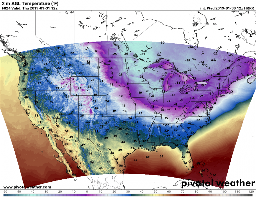
12z HRRR shows Rockford IL as the coldest place in the country tomorrow morning:
-
14 minutes ago, Hoosier said:
Tomorrow morning kinda looks like the morning of 1/19/1994, but shifted northwest since the surface high is farther north this time. So if you take a look at what happened in central/southern IN that morning, it may be a decent guide to what happens in northern IL, but even colder potential.
Agree...that's a good way to look at it.
Just need to watch for high clouds coming in with the next clipper...but, even so, temps will still have a long time to crash before that.
-
12 minutes ago, RCNYILWX said:
We dialed into the ASOS and ORD officially got down to -23 this AM. The -24 was due to a rounding issue on the 5 minute obs site.
Sent from my SM-G965U using Tapatalk
Thanks for the clarification!
Still very impressive; today will go down as the 2nd coldest day in Chicago history (-16.5 daily mean temp).
-
1
-
-
9 minutes ago, Chicago WX said:
Impressive.
My work came to their senses and cancelled delivery today. I am thrilled.

As for tomorrow morning, number to shoot for at IKK is -29˚....the all time coldest "officially" recorded here (back in Jan 1985).
Great to hear! This is really an impressive airmass, something I honesty never thought I would see in this area.
ORD is still -21 at 10 AM central. RFD -22, De Kalb -23.
-
Chicago will destroy 3 of these 4 daily records, and may break the 4th one:
Jan 30: low -15 (1966); low max 3 (2004)
Jan 31: low -12 (1985); low max 1 (1971)
It also looks like today will be the 2nd coldest daily mean temp in Chicago history:
12/24/1983: -18 (-11/-25)
1/30/2019: -16.5 (-10/-23)
1/18/1994: -16 (-11/-21)
Edited to correct today's low at ORD, to -23.
-
7AM obs:
ORD -23, dew -32, wind W 20G30, WC -52
RFD -25, dew -35, wind W 14, WC -51
-25 here.
-
ORD and RFD need to start dropping fast. -4 and -6 at 8:00 PM. Need to get to -12 and -15 by midnight to have a chance at the all time coldest max tomorrow.
-
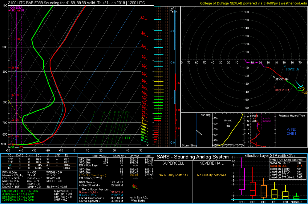
3 minutes ago, Hoosier said:
Here's a RAP forecast sounding from northern IL Thursday morning. The mother of all inversions... probably overdone, some.
Besides the -43 temp, check out the dewpoint of -54 lol

-
17 minutes ago, Knightking2018 said:
The weather channel is forecasting a wind chill of -52F for Lake Zurich, Illinois. This will probably be one of the coldest days you ever felt Mr. Beavis.
Yep...coldest I have felt was -45 on 1/6/2014, I think we will easily beat this.
-
Crookston, MN is -26 with a WC of -62...at 2:00 PM local time! That is just shocking beyond belief. May be ice fog too, considering the 1/4 mile visibility.
CROOKSTON CLOUDY -26 -33 68 N32 30.24S VSB 1/4 WCI -62
-
Wow at the Euro. If some of the low-lying locations in IL (Rochelle, Aurora, Sterling) can max out at only -15 on Wednesday afternoon and then clear out Wed night, I imagine the state record low of -36 is in jeopardy. Still to early to pin down these details...but it's certainly possible.
-
And here it comes...
Grand Forks ND at 11 AM central: temp -25, winds N 29 G 43, wind chill -59.
Coldest wind chill so far: -61 at Flag Island MN, -27 with NW wind 25 mph.
-
1 minute ago, Hoosier said:
I'd figure about a 10-12 degree diurnal recovery at ORD, so hope it tanks like crazy tonight to give some wiggle room.
Agree...and many of the models are showing exactly that.
As an example, 12z GFS shows -4 at RFD at 6PM tonight, crashing to -22 by midnight...wow.
-
-
While I think Chicago and Rockford will be comfortably safe from the "midnight high" on Wed morning, some of the models are showing that it may warm up enough on Wed afternoon to prevent breaking the all-time record low maxes (-11 Chicago and -14 Rockford)...before temps tank again at sunset.
Yesterday, I thought we'd have a 90% chance of this record being broken at both ORD and RFD...but right now I'd say 60-70%.


January 24 - 31 Cold Blast
in Lakes/Ohio Valley
Posted
Looks like ORD is still -15 at 7pm. Need the winds to start lightening up, as there really isn't any significantly colder air to advect from elsewhere.
RFD down to -19, as the winds have dropped off to 9 mph. DPA and DKB -17.
Today is the coldest day in Rockford's history. Daily average temp -19 (-13/-25), breaking the old record of -18.5 (-14/-23) on 1/18/1994. And the record could be broken even more if RFD drops below -25 before midnight.