
heavy_wx
-
Posts
1,614 -
Joined
-
Last visited
Content Type
Profiles
Blogs
Forums
American Weather
Media Demo
Store
Gallery
Posts posted by heavy_wx
-
-
2 minutes ago, WxUSAF said:
Picking back up quickly. That yellow band that's about to cross the Potomac looks fun.
Yeah, bigger and fluffier aggregates starting to mix in here.
-
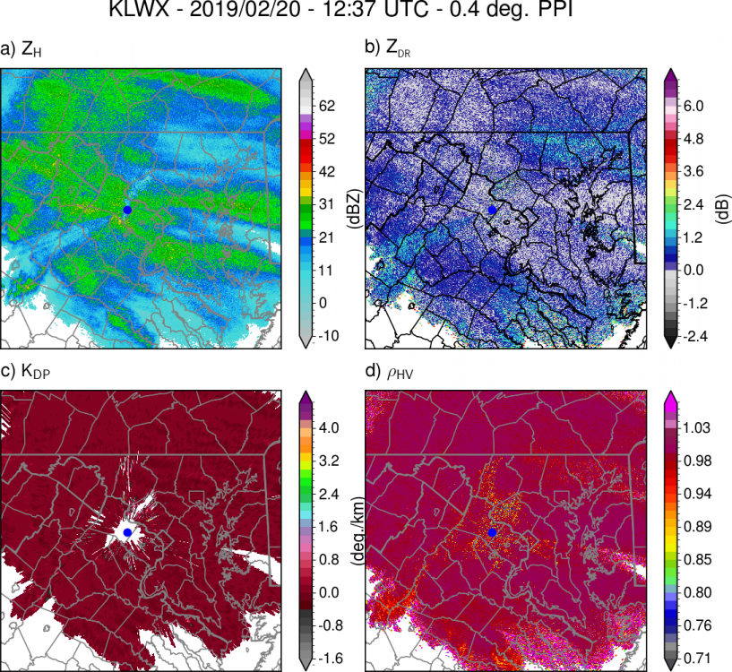
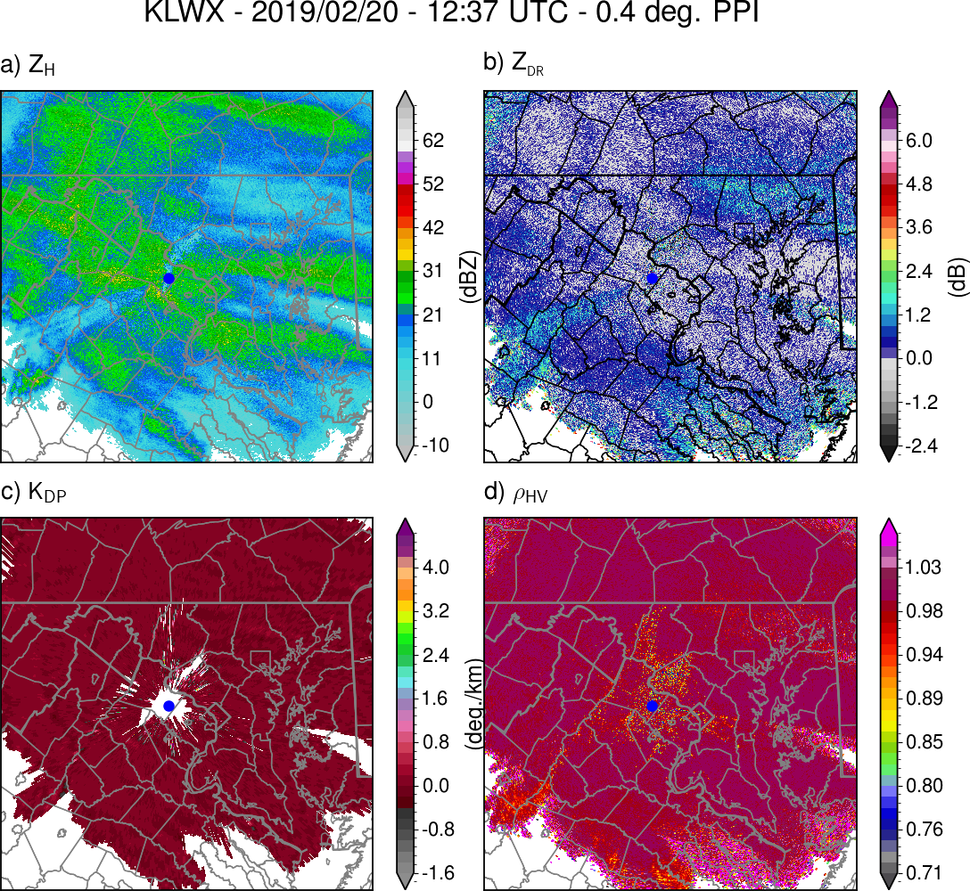
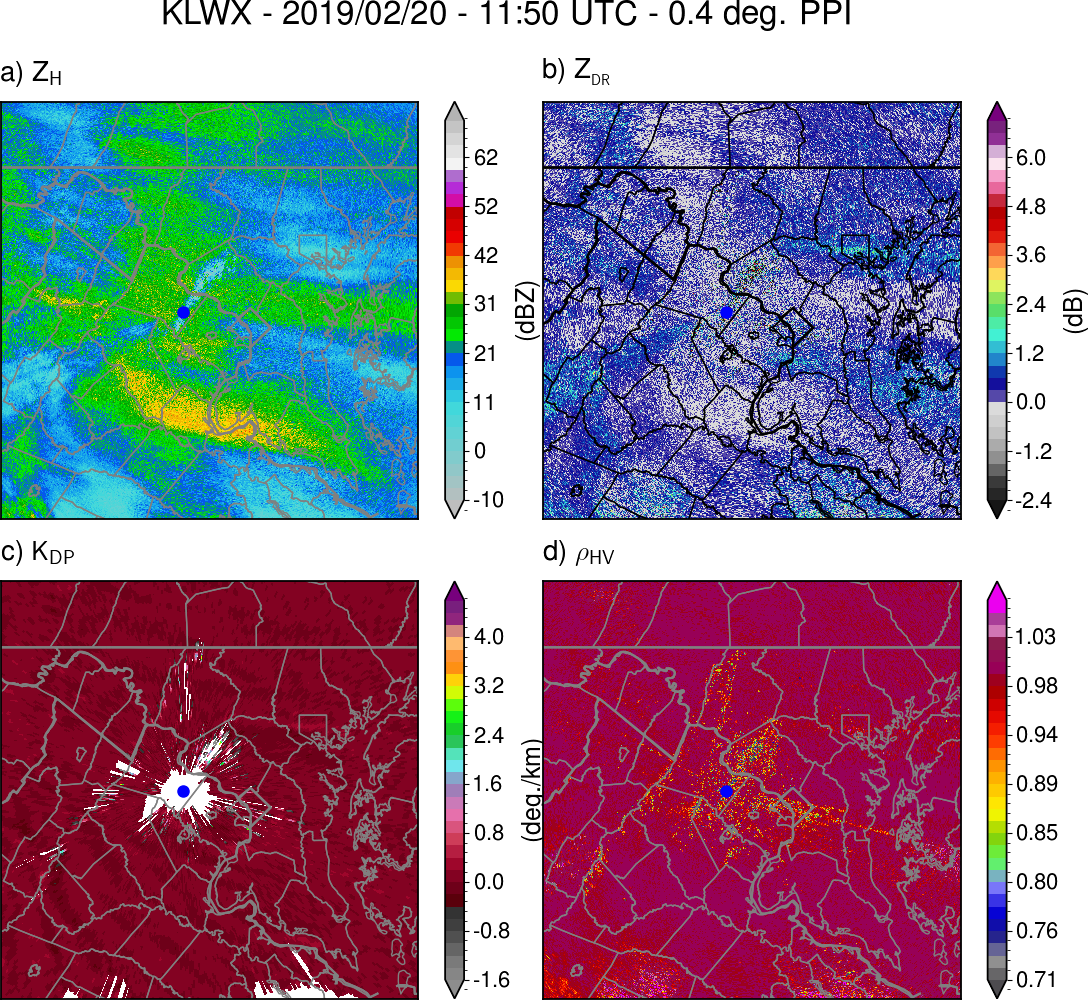
There are some reduced RhoHV values north and east of Albemarle County indicating sleet mixing. Still > 100 km from the LWX radar. Also, enhanced ZDR values outside of the heaviest bands indicate good ice crystal growth. Decreases in ZDR and large increases in reflectivity (ZH) in the heavier bands indicate an efficient aggregation process as the aggregates lose their horizontal alignment/extreme aspect ratios.
-
 2
2
-
 2
2
-
-
Small aggregates here, but the visibility has dropped noticeably with the enhanced reflectivity over southern Howard County. Probably some pristine ice crystals mixed in as well based on the areas of larger ZDR on radar.

-
1
-
-
Light snow has begun in North Laurel.
-
2
-
-
2 minutes ago, mattb65 said:
Well I think you need to adjust your previous posts - you seemed to indicate a transition Snow straight to Rain is what you expected.
I think most agree with what you said in this post it'll be snow then pingers - duration TBD - NAM/Euro suggest only a few hours before going to ZR/Rn, other models suggest maybe a bit longer. With strong WAA like what is modeled and a retreating HP, I agree that a long duration pinger fest isn't all that likely.
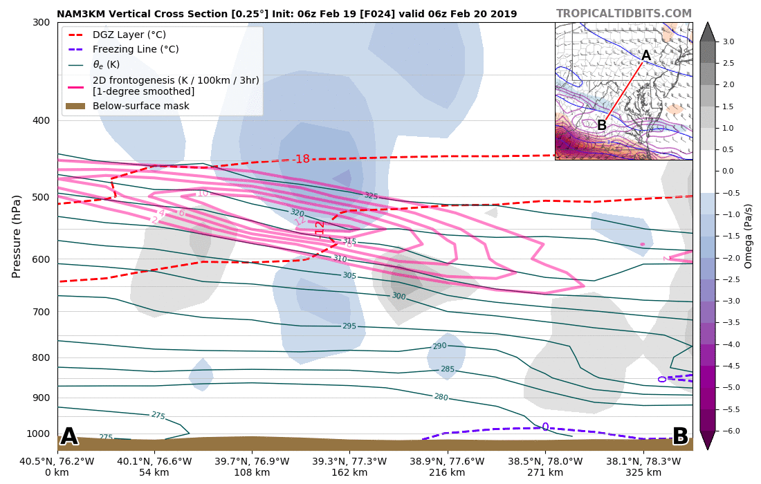
Yes, the depth of the warm layer increases rather quickly (see the cross-section animation below). The surface is usually the slowest to warm in these types of events with strong HP/ageostrophic low-level flow of cold air.
Guidance from the 06z 3-km NAM shows forcing along the frontal surface decreasing in height with time; the greatest frontogenesis over our area is around 600 mb at ~12z, and the frontogenesis weakens and decreases in height with time (tracing the frontal surface). The dry air present at the low levels ahead of the precipitation makes me question if the more intense (>1-2"/hr) snowfall rates will occur beyond a brief period, especially as the forcing weakens after 12z.

By the way, the cross-section feature from Tropical Tidbits is fantastic!
-
3
-
1
-
 1
1
-
-
29 minutes ago, MillvilleWx said:
I was noticing that too. There is a pretty stout area of PVA moving through in the PM around that time, so I wonder if a rumble of thunder is not out of the question. With lift like that through the DGZ, there should be some charge build up. We shall see
It's certainly possible, especially if we get a lot of graupel forming.
Getting some flurries here now.
-
1
-
-
32 minutes ago, MillvilleWx said:
The 3km is showing a healthier expansion of the qpf further west due to the increased H7 frontogen along the Allegheny Front. Coupled with a solid jet streak placement over PA placing the area in the right entrance of the jet, this would provide the region with better lift, maxing both qpf and dendritic growth as the greatest omega will be positioned right within the DGZ (See pic below). This is all solid trends for west of the bay, but east of the bay might maintain a tongue of warmer air aloft, limiting the chances of seeing more prolific snowfall. However, as the trough axis swings overhead, a decent area of PVA will accompany the trough base, so a secondary burst of precip on the eastern shore is possible before exiting. Places like Parr's Ridge are obviously in the best spot due to the slightly colder temps locally and the added orographic enhancement as the front swings east.
It'll be important to monitor the trends in guidance at 12z. Mesos SHOULD have a better handle on the setup closing in, so any step forward or backward could be pivotal to the final outcome. Have to like the trends this morning.

Interesting thermodynamics with this event too. Both the 06z GFS and 3-km NAM have a region of convective instability and associated elevated lapse rates between 650-550 mb this afternoon (you can see the decreasing theta-e with height in that sounding near 600 mb).
-
2
-
-
There's some convective instability in the mid-levels (~600-700 mb) at BWI on the GFS for Tuesday afternoon ahead of the first cold front; lapse rates in this layer are about 7C/km.
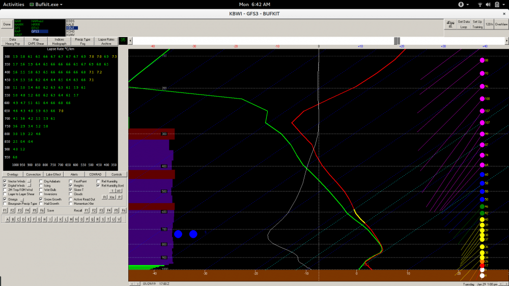
Additionally, there is some moderate frontogenesis associated with the strengthening boundary just below this layer. This forcing in the convectively unstable region would allow for the some mid-level convection to be realized. The location of the unstable region is also within the dendritic growth layer, favoring more efficient ice crystal growth; isothermal temperatures near 0C below 850 mb would also support very large, wet aggregates. Of course, these temperatures may also turn out to be marginal for precipitation staying all snow.

-
7
-
1
-
-
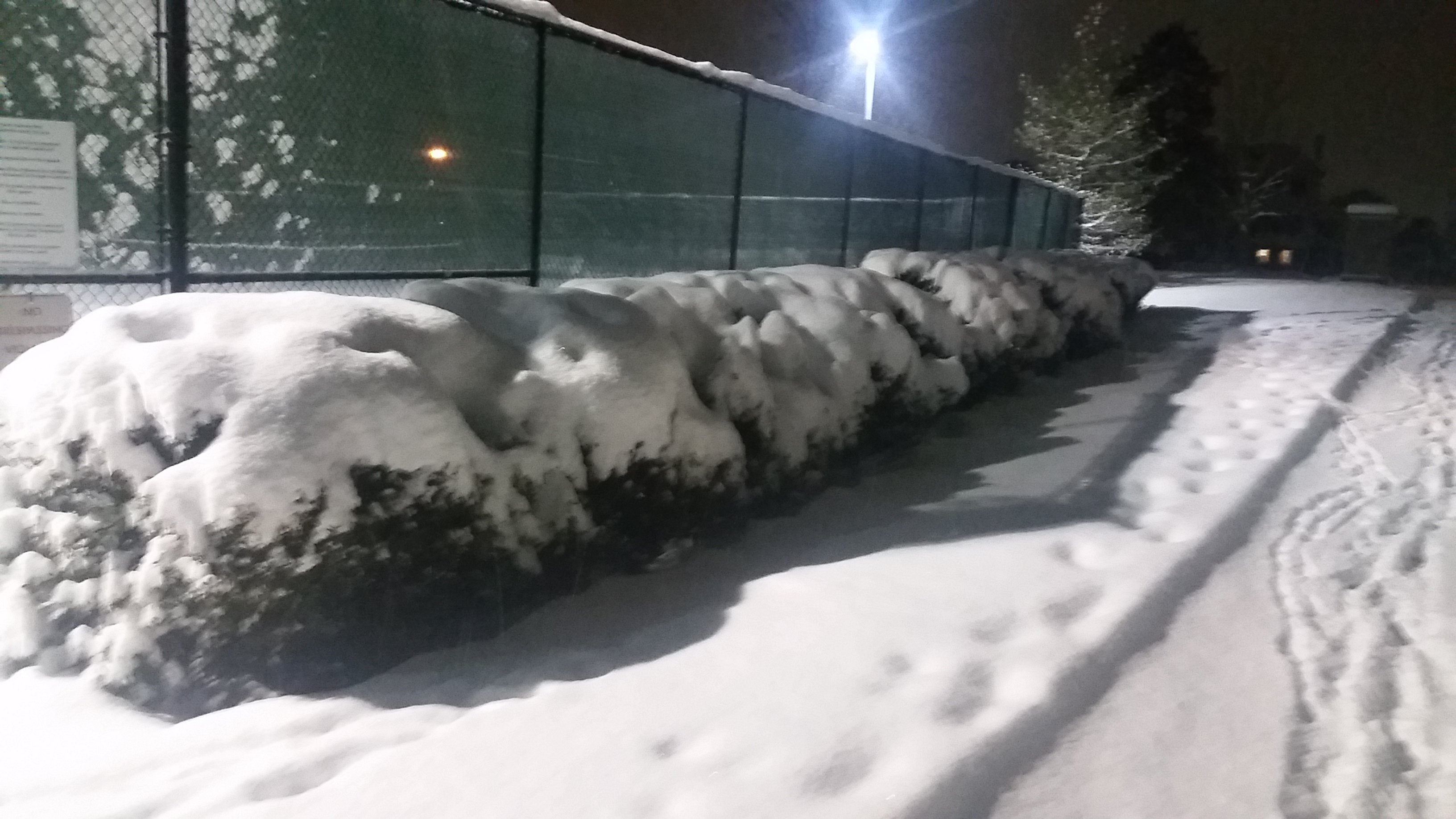
Light/moderate snow here in North Laurel.
-
Measured about 9.5" on the ground here.

-
3
-
-
4 minutes ago, WxUSAF said:
aka perfect snow to accumulate fast. Dumping right now.
Yeah, definitely high SLR.
-
1
-
-
Low-density fluff falling out there. Nice aggregates composed mainly of rimed dendrites.
-
1
-
-
Just now, osfan24 said:
I'm sitting in the dark greens right now with the yellow band literally a couple of miles away at most and backing into me and it's not snowing above a light snow shower. Not sure what gives.
I think the snow detected by the radar is > 500 m above the ground, so with the N wind, it has moved several km south by the time it reaches the ground. I noticed this as the band approached me in North Laurel, where the precip didn't become all that intense until the center of the band was above me.
-
2
-
-
Getting some moderate-sized aggregates now and reduced visibility within the band of 35-40 dBZ reflectivtiy.
-
1
-
-
Getting a steadier light snow here on the northern edge of the band approaching Howard county. Still relatively small flakes.
-
Getting bigger aggregates now, corresponding to increased reflectivity and reduced ZDR.
-
1
-
-
Measured about 5" on the ground with light snow in North Laurel.
-
4
-
-
Confirmed clumps of dendrites/planar crystals falling within the band of higher reflectivity here. Maybe 1-2" on the ground so far.
-
Light flurries here in North Laurel.
-
1 minute ago, MillvilleWx said:
I've been waiting for you to chime in Heavy. Good to hear from you on this one. Looks like your area will be getting the goods down there in Laurel
Yeah, hopefully it will be a good storm for us down here (my first). It will certainly be interesting to see how the banding sets up.
-
1
-
-
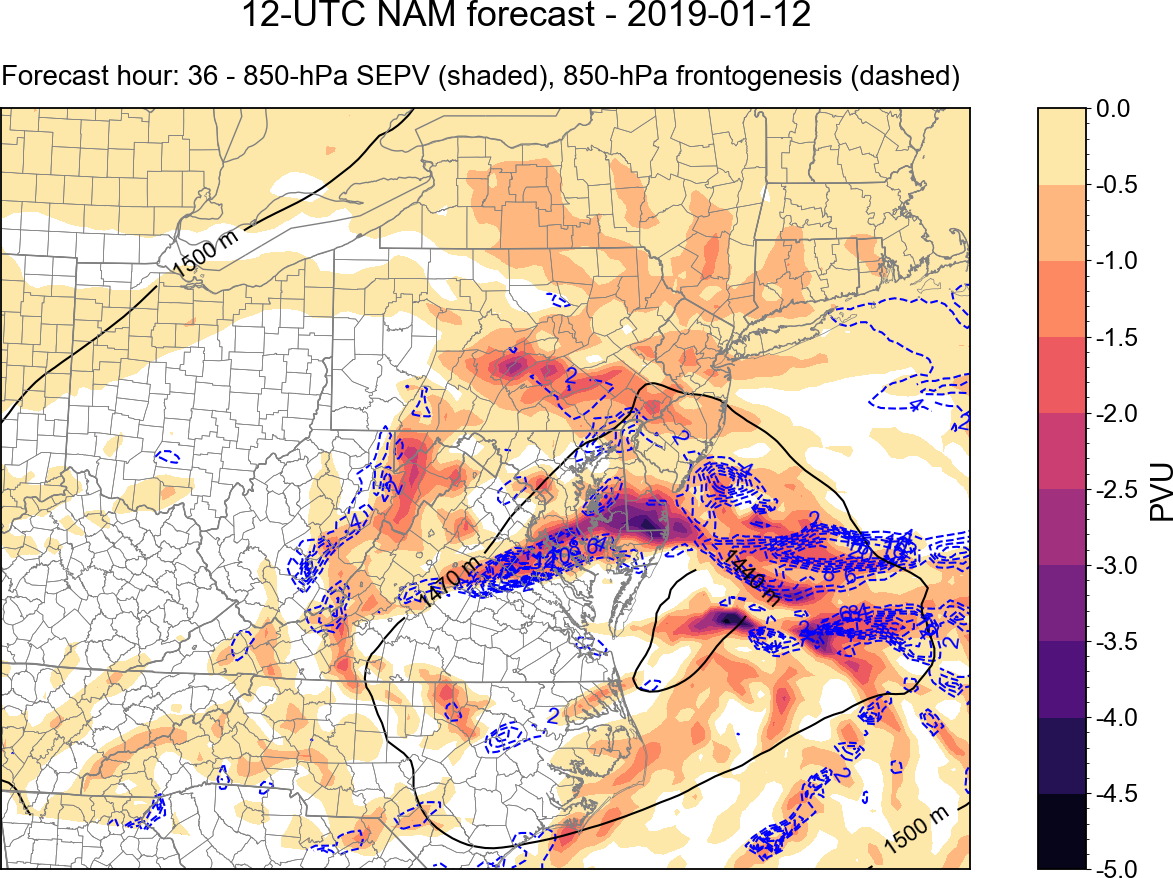
Just for fun, here is a good example of mesoscale banding indicated by some diagnostics of the 12z NAM.
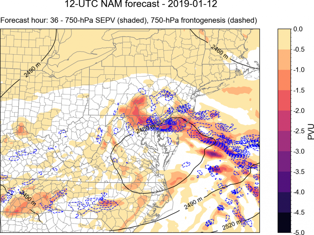
The 750 mb heights (black), frontogenesis, and saturation equivalent potential vorticity (SEPV) are plotted above. SEPV is a measure of the stability of air parcels to slantwise and/or vertical displacements in a saturated environment. Regions of negative SEPV have been associated with mesoscale precipitation bands in winter storms. You can see that there is a band of negative SEPV from east of the Delmarva to northern MD, to the north of the closed 750-mb height contour.
There is also enhanced 750-mb frontogenesis in this region, associated with a thermally direct circulation (i.e., warm air rising to the south, cold air sinking north). This circulation provides lift, and in the aforementioned environment of conditional stability, leads to enhanced vertical motion within the general synoptic ascent.
An important thing to note with these diagonistics is that these circulations and regions of conditional instability occur within layers of the atmosphere, and are often sloped. For example, here is the same plot but for 850 mb:

You can see here that the main region of conditional instability and enhanced frontogenesis is displaced to the south over central VA and SE MD. These two levels are different horizontal slices through the same circulation; in this case the circulation is sloped to the north with height. Where this circulation intersects the dendritic growth zone (DGZ) is often where the most intense banded precipitation occurs, due to the region having the most efficient ice crystal growth and aggregation.
For more information, this is one good resource: http://cstar.cestm.albany.edu/CAP_Projects/Project6/Mesoscale_Structure/seminar (M. Greenstein).ppt
-
8
-
6
-
-
Large, wet aggregates here in North Laurel, MD.
-
1
-
-
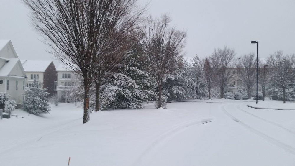
Measured about 9" on the ground this morning.
-
2
-
-
Measured about 7" on the ground here; started the transition to sleet and freezing drizzle in the relative lull in precipitation rate south of the band.


2/19-20 Winter Storm Observations
in Mid Atlantic
Posted
Measured about 1.5" on the ground in North Laurel. Saw a good mix of thin columns/needles, rimed dendrites, and small/moderate-sized aggregates.