

heavy_wx
-
Posts
1,614 -
Joined
-
Last visited
Content Type
Profiles
Blogs
Forums
American Weather
Media Demo
Store
Gallery
Posts posted by heavy_wx
-
-
Getting some moderate-sized aggregates now in North Laurel.
-
Actual light snow here in southern Howard County.
-
 1
1
-
-
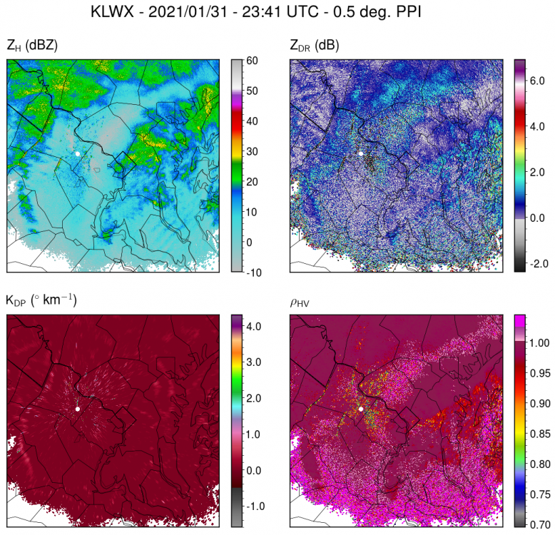
Finally getting some bigger aggregates and moderate snow within the higher reflectivity area from PG County into Howard County. Correlation coefficient and ZDR suggest that southern AA and PG county are starting to mix.
-
1
-
-
5 minutes ago, WxUSAF said:
Visibility down to 0.5”mi or so, so legit mod snow. Keep this up for a few more hours and 4-5” will be easy.
Took a drive to get my daughter and side roads all covered. Even main roads a little slushy.
Snow growth here in southern Howard County is still quite poor, with small single crystals.
-
1
-
-
Mostly needles in the lighter snow outside of the heavier bands here. Not too surprising given cloud-top temperatures in central MD are only around -10C.
-
Getting larger, more aggregated snow now corresponding to higher reflectivity (>20 dBZ) and ZDR closer to 0 dB.
-
1
-
-
Light snow with tiny flakes here.
-
Light snow here in southern Howard County with minimal accumulation so far.
-
2 minutes ago, Hypothetical 240 hour snow said:
Euro ptype looks wonky, with that low position, after initial WAA thump, would probably be mostly rain SE of I-95, so not trusting its explicit ptype in the CCB... hard to tell with thermals at this point on a global model but accumulating snow in a Miller B coastal at that latitude seems unlikely unless precip intensity was very high.
Will still take 3-6 assuming rain doesn't melt it all.
There's a pretty consistent emergence of a warm layer on most guidance between ~800-900 mb (except the GEM/RGEM) ; 850-mb temperatures generally get above freezing up to the MD-PA border between 06-12z on the Euro. The duration of snowfall from the coastal low will depend on the degree of mesoscale forcing and the low track, and these features are highly correlated since the best mesoscale forcing is north of the 700-mb low.
-
2
-
-
The 700-mb temperature gradient is definitely tighter on the 12z GFS compared to 06z, leading to greater frontogenetic forcing over the I-95 region. The model is also a bit colder, but its forecast boundary layer is still warm enough for rain for a time near and SE of I-95. If the stronger dynamics verify, I think the boundary layer could be less of an issue, especially given the favorable surface high position in SE Canada. Of course we could have those issues if the models end up developing the surface cyclone farther northwest.
-
2
-
 5
5
-
-
6 minutes ago, WxUSAF said:
I just actually looked at the euro run on my computer now for the first time. My God that's just perfection. And cold leading into the storm!
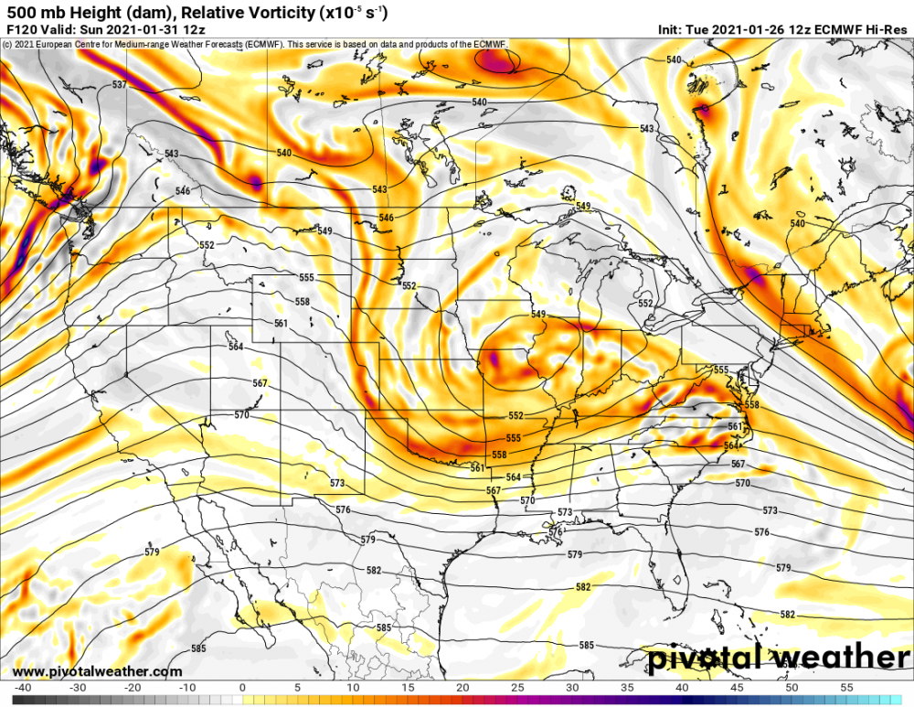
Lovely bifurcation of the mid-level flow! The resulting confluence promotes anticyclogenesis south of James Bay and cold-air damming into the mid-Atlantic.
-
9
-
 4
4
-
-
Light to moderate snow here with a coating on the ground.
-
6 minutes ago, Buddy1987 said:
Would you consider that to be a bias of the euro with s/w ejection with systems coming out of the southwest like we’ve seen in past storms?
Good question; I'm not sure if the differences in the shortwave evolution are caused by something inherent in the model dynamics or differences in the model initial conditions.
-
1
-
-
20 minutes ago, CAPE said:
It was close. Looking at h5, there are some subtle differences between the Euro and GFS. The biggest one may be the spacing between the developing shortwave and the big NA vortex. A bit more on the GFS, and so it is able to develop more ridging out in front.
Yes, the GFS keeps the 500-mb shortwave mostly coherent as it propagates from AZ on 12z Tuesday to the OH river valley, where it acquires a negative tilt.The shortwave on the Euro loses its coherence over the southwest, keeping some of the energy delayed as the feature moves eastward. The result is a flatter, positively tilted shortwave that produces less favorable interaction with the developing surface low.
There's definitely potential with this system for snow in the mid-Atlantic, but I think there's too much uncertainty right now in how these features will evolve to be confident in any operational model solution.
-
2
-
4
-
-
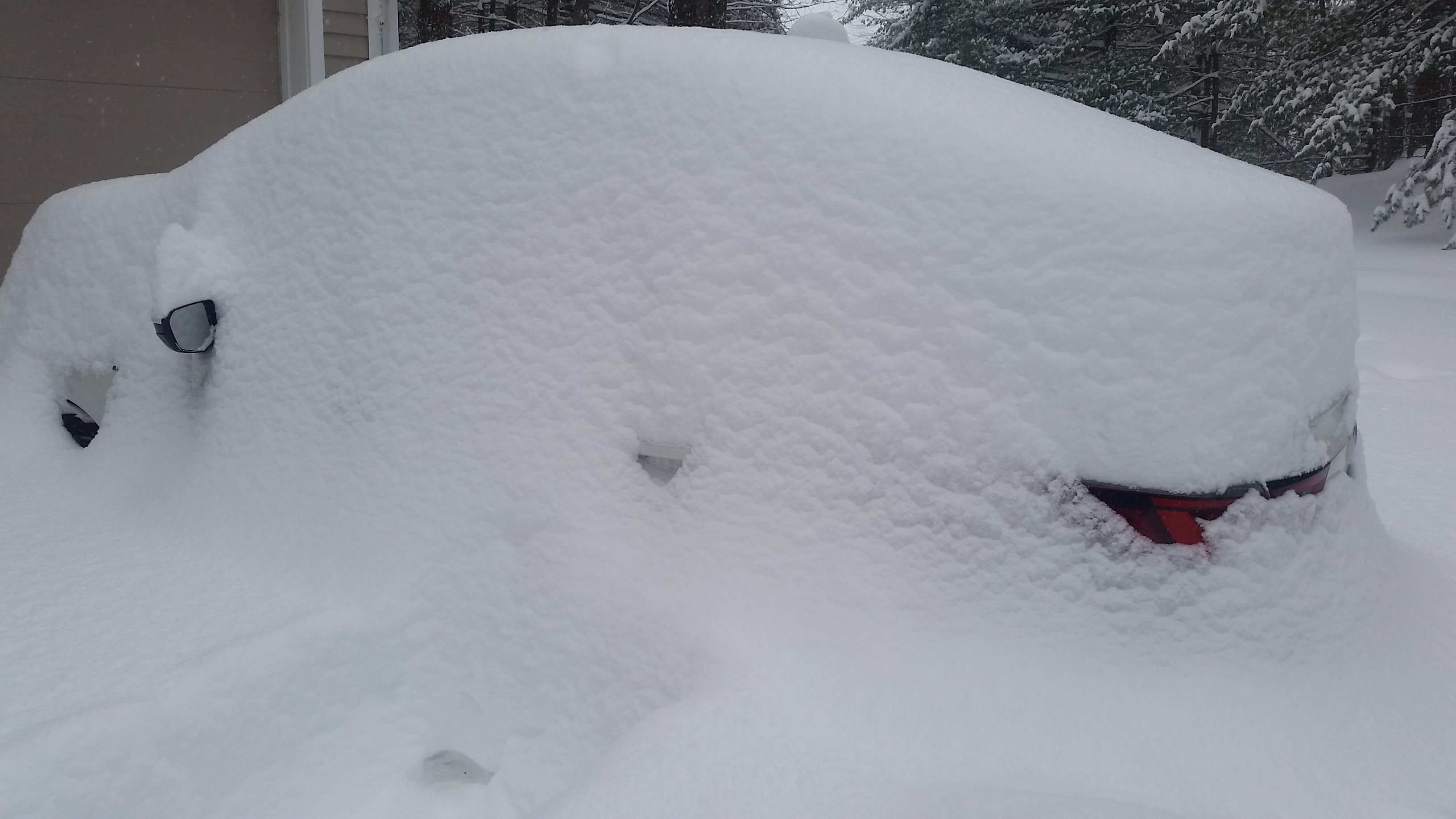
Measured about 19" depth on the ground NW of Albany about an hour ago.

-
10
-
-
5 minutes ago, USCAPEWEATHERAF said:
Can you post one from the Taunton radar site?
-
1
-
-
2 minutes ago, USCAPEWEATHERAF said:
Is this found at COD weather too or is a paid site
I plotted it from the level-2 NEXRAD data (https://registry.opendata.aws/noaa-nexrad/).
-
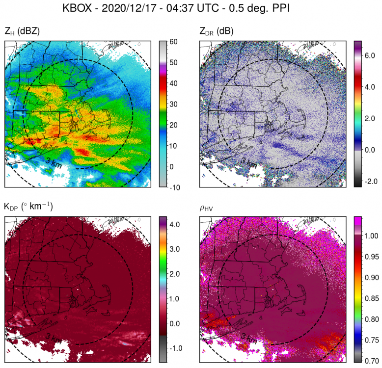
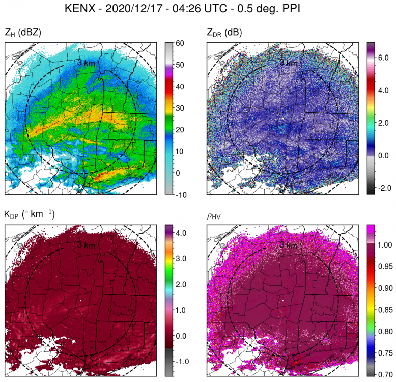
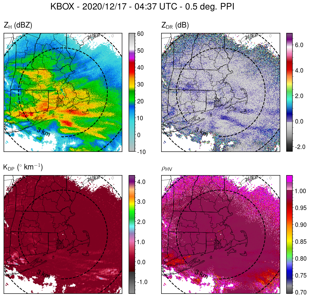
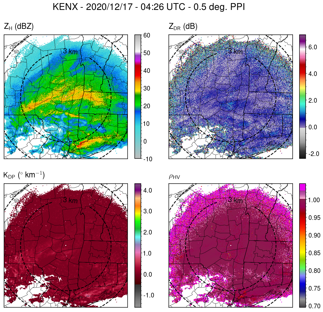
Just into the band here in Albany, finding a lot of dendrites and moderate-sized aggregates of dendrites. Corresponds to enhanced reflectivity, KDP, and ZDR within the band from KENX.
-
4
-
1
-
-
Some light snow started here within the last half hour just NW of Albany.
-
32 minutes ago, Stash said:
Things look good for at least a moderate snowfall out this way, but there are oddly few of us in ENY on here. Meaning east of Utica, and in the Albany-Glens Falls corridor. I think I remember there being more of us in the old Eastern US weather board. There's little point in celebrating alone, lol. ALB, Saratoga, and the eastern Mohawk Valley down to BGM look to do OK, as far as Upstate is concerned. Maybe areas up to the Thruway corridor can hopefully get something decent out of it too.
I'm up near the Albany area for this storm...I think it will be better here than where I'd usually be, along I95 in MD! My main concern is if the secondary mid-level (~700-mb) band stays just south of ALB, and we're stuck in the subsidence zone of the circulation during the period of heaviest snow.
-
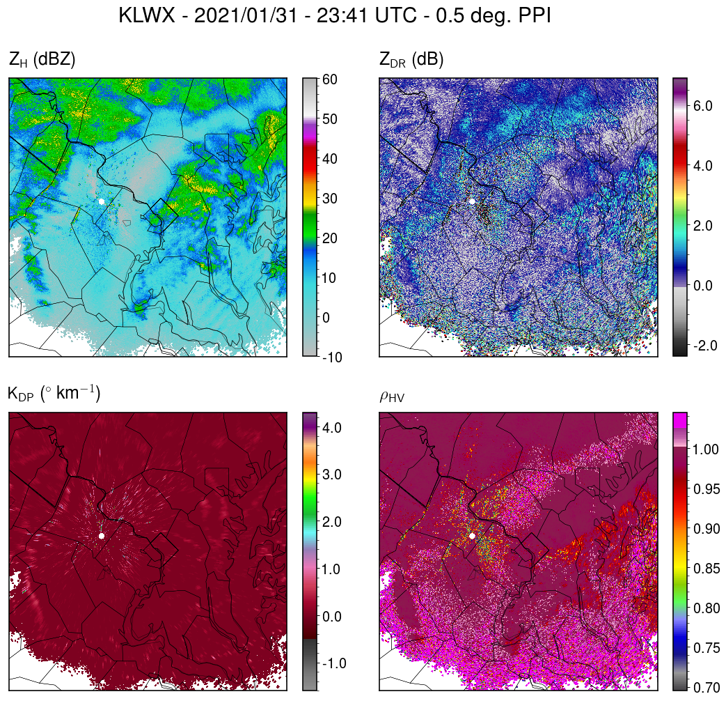
2 minutes ago, Eskimo Joe said:
I'm thinking the TORs are coming off the terminal radars because the velocities off LWX don't appear too impressive.
There's a relatively good indication of 1-km AGL rotation from KLWX for the storm west of Baltimore City. Also some shear-induced size sorting evident in the relative placement of the ZDR and KDP maxima.
-
1
-
1
-
-
1 hour ago, mappy said:
mmmmm not sure, but ill take your word for it.
in the end, our positive cases are going to continue to rise as we test more residents. and it should be expected every time there is an update. it shouldn't be a metric for reopening and it shouldn't be something to fret over.
The new positives reported each day would eventually decrease if the infection rate of the virus slows (R0<1), even with increased testing. This happened in New York State, where they have seen both a decrease in # of positives and in increase in # of tests. https://covid19tracker.health.ny.gov/views/NYS-COVID19-Tracker/NYSDOHCOVID-19Tracker-DailyTracker?%3Aembed=yes&%3Atoolbar=no&%3Atabs=n
-
4 hours ago, PDIII said:
I am sad to report that I woke up with a 102 fever this morning and a really bad sore throat.
Sorry to hear. Hope you feel better soon.
-
6 minutes ago, PDIII said:
@heavy_wx If (conservatively) 50,000 people in the US have Corona Virus (JHU) and probably more accurately a half million (read the article) and as you report ~10 of COVID-19 case are serious enough to require ICU treatment.... how are our hospitals not overwhelmed currently?
As an example, NY state (as of the Governor's briefing today) has ~700 confirmed cases and 65 people currently in ICU beds. Beyond the confirmed cases, it's hard to know how many people are asymptomatic, so I take your point that the percentage could be lower when factoring in these unobserved cases. The troubling thing is that the number of confirmed cases increases exponentially with time, unless serious social distancing measures are implemented. Italy has *only* 24k cases but its health care system is overrun with COVID-19 patients in critical condition. 16 days ago, Italy had about the same number of cases NY has currently.

Jan 31st - 33rd Storm Obs and Disco like it's 1979
in Mid Atlantic
Posted
Moderate snow with low-density fluff in this band. Reminds me of lake effect.