
heavy_wx
-
Posts
1,614 -
Joined
-
Last visited
Content Type
Profiles
Blogs
Forums
American Weather
Media Demo
Store
Gallery
Posts posted by heavy_wx
-
-
17 hours ago, mappy said:
depends on who you ask. i think many would say one storm doesn't make a winter. without that Jan blizzard, almost everyone would have had less than 10 that year (myself included)
Yeah, that was a terrible winter for State College; despite getting 7" from that storm, we tied the all-time record for lowest seasonal snowfall.
-
 1
1
-
-
Light snow here in North Laurel.
-
Didn't see any snowflakes here.
-
Getting some relatively large aggregates with this squall here.
-
1
-
-
Measured a final total of around 2".
-
Moderate to large aggregates out there, though looks to be ending pretty soon. I could definitely see some pristine dendrites attached within some of the larger aggregates, so these low-density particles will help bump the snowfall accumulation/ratios here.
-
1
-
-
3 minutes ago, high risk said:
Getting stickage now in southern Howard County. Impressive rates.
And the aggregates are starting to get bigger here.
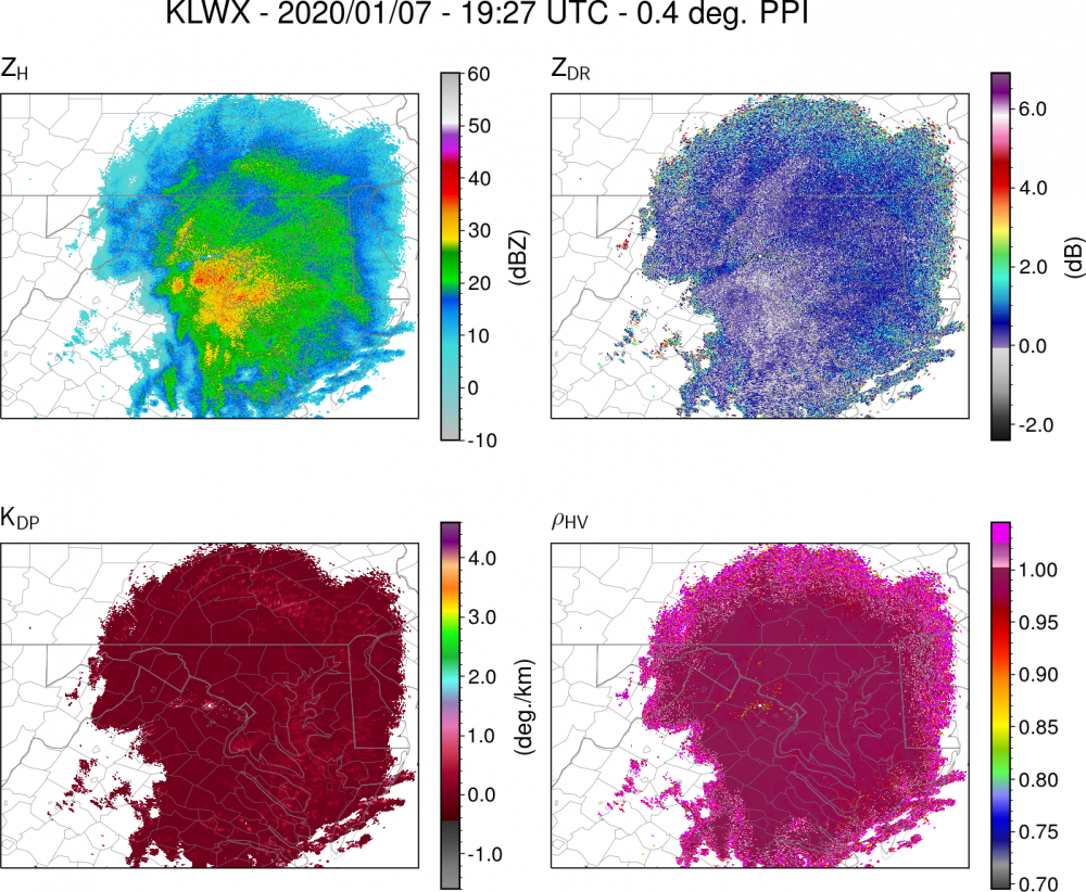
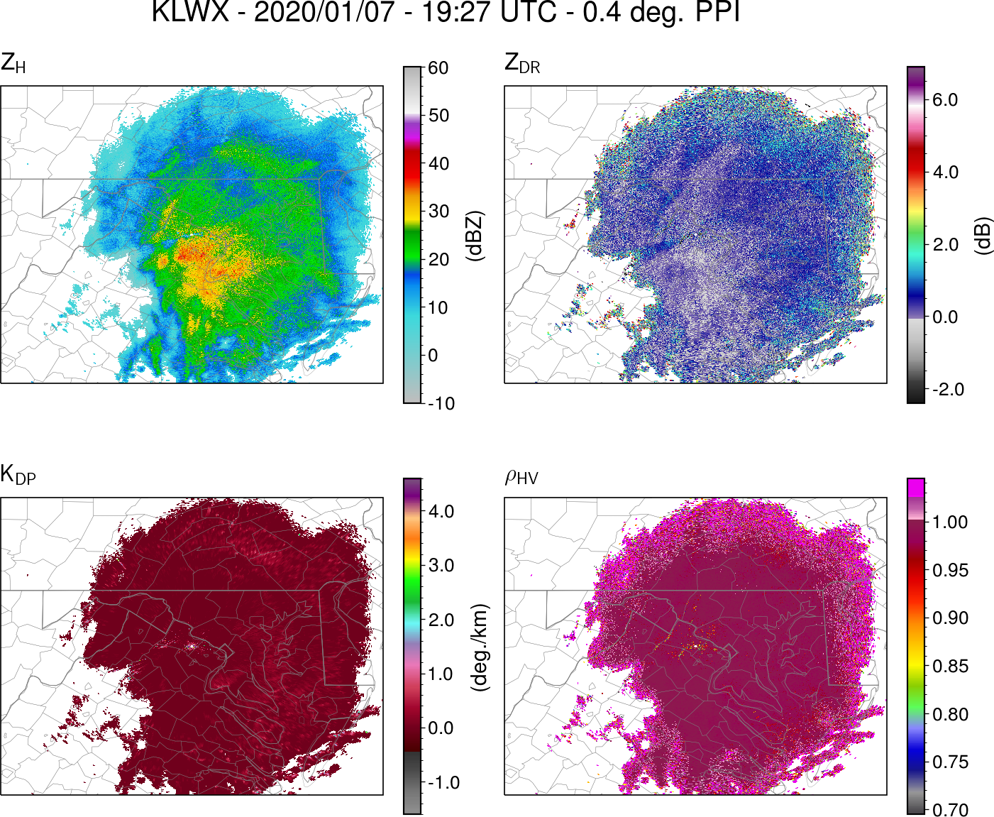
Coincides with a dendritic growth signature on radar, where ZDR and KDP are somewhat enhanced in the precip east of DC, farthest from LWX where the radar beam is higher. Another slightly more substantial dendritic growth signature is also visible over southern PA.
-
5
-
-
Getting a steady light snow now with wet but mostly frozen aggregates
-
Left work around 12:30 and just started to see rain around the 95-495 split near Beltsville, MD. Now getting some light flurries here in North Laurel.
-
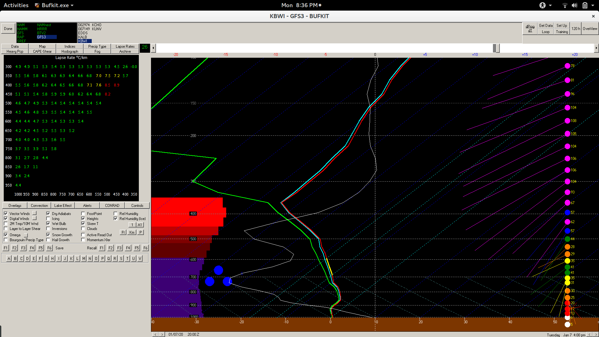
Forecast wet bulb temperature profiles definitely look colder at low levels than a few days ago, with 18z NAM and GFS profiles below 0C everywhere above the immediate surface layer (see BWI forecast sounding below). A deformation zone between 800-600 mb is aligned relative to the temperature gradient such that there will be frontogenesis-induced lift within this region. Vertical motion in this layer will have pretty good overlap with temperatures favorable for dendritic growth, with the subsequent aggregation of these dendrites producing relatively large, low-density ice particles. These low-density particles should help to increase snow-liquid equivalent ratios, though surface temperatures at or slightly above freezing could counteract these enhanced ratios somewhat. It will be interesting to follow this tomorrow, and I kind of wish I had planned ahead to telework!

-
7
-
 1
1
-
-
4 minutes ago, Bob Chill said:
EPS says the op is close to best case scenario. Majority of eps members are nothingburgers.
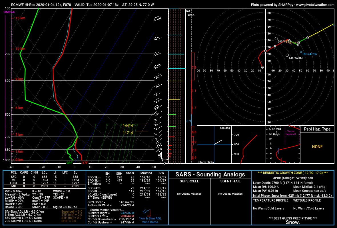
And even the operational 12z Euro has fairly mild boundary layer temperatures for the I95 region (see sounding below). Unfortunately not a great pattern for low-level cold air with the progressive 500-mb troughs in SE Canada/lack of a strong, cold anticyclone.

-
1
-
-
Measured about an inch of snow here in North Laurel. Currently sleet with a few snowflakes mixed in.
-
Large aggregates falling here in the last few minutes (since I woke up), with a coating of snow on the road.
-
Dusting of snow on elevated surfaces here.
-
1
-
-
Wet aggregates falling here.
-
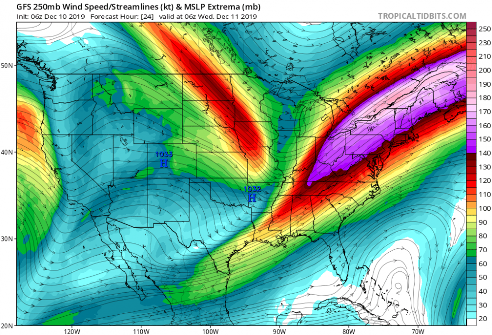
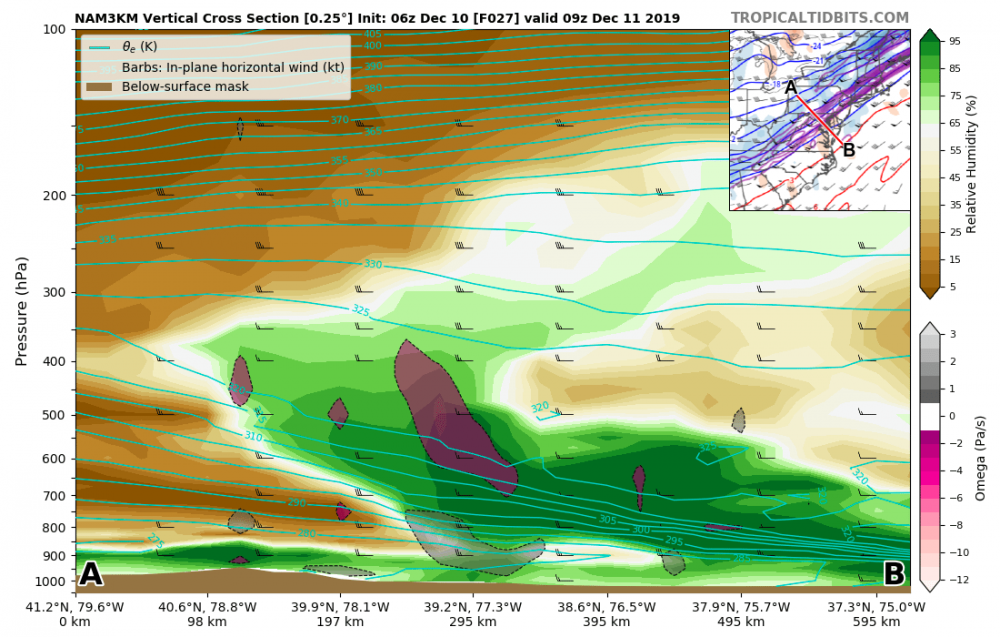
Classic looking frontal circulation for this setup. The temperature gradient associated with the SW-NE oriented front strengthens as the boundary moves eastward, creating a thermally direct mesoscale circulation about the front, with warm air on the SE side of the boundary rising and sloping westward with height. This circulation is associated with the right entrance region of a jet streak that also strengthens with time as the thermal gradient intensifies.
The frontal circulation can be seen on forecast cross-sections normal to the orientation of the boundary, where enhanced frontogenesis slopes westward with height. Additionally, there is some relatively low stability air above the frontal surface. In the cross section below, you can see the small closed contour of 320-K theta_e between -12 C and -18 C, indicating convective instability within the dendritic growth zone. This environment would be very favorable for ice crystal generation and growth.
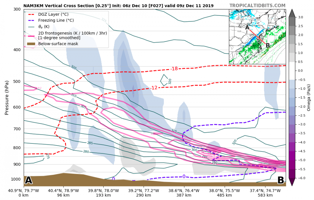
This cross section also highlights the marginal boundary layer temperatures for this event (typical for these anafrontal precip setups), where the 0-C contour extends above the frontal surface to around 700-mb. The above freezing temperatures will limit the period of snowfall to a narrow window of favorable frontal dynamics and sub-freezing temperature profiles. Right now, it's hard to say how long this window will be.
Finally, you can also see the advection of low-level dry air on the cold side of the front which may lead to more sublimation of ice particles and less snowfall at the surface, especially during the tail end of the precip.
It should be an interesting event to watch, and perhaps I will finally see some snowflakes this season!
-
17
-
3
-
-
Starting to get a wet coating of snow on the grass here with steady, light snow.
-
1
-
-
Light snow with small flakes here in North Laurel.
-
9 hours ago, AmericanWxFreak said:
What part of N Laurel? I’m in Maple Lawn!
I'm just a bit east of you, near 95.
-
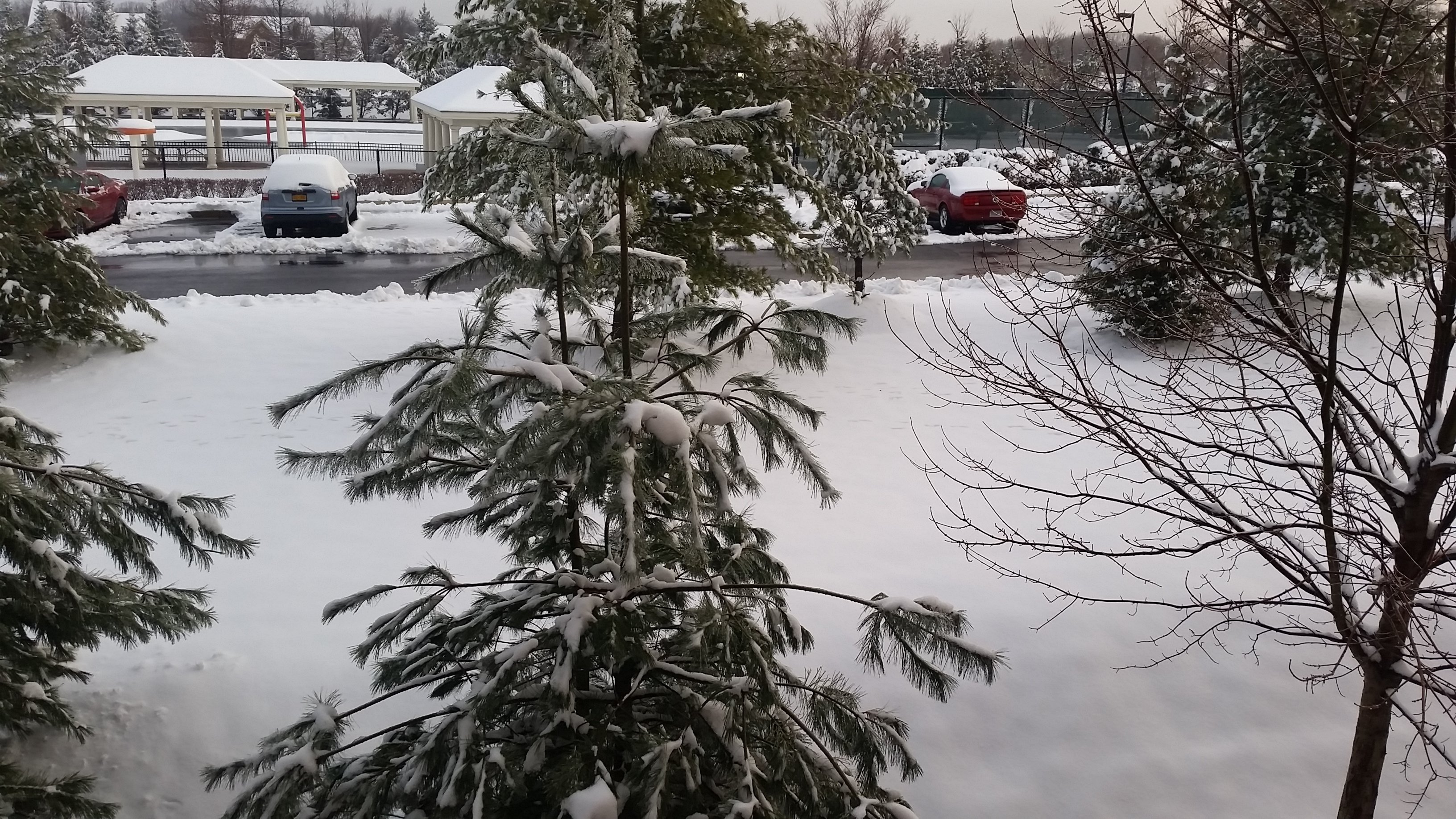
Still looking wintry out this morning. I did notice a bit of ice accumulation on the tree branches here in North Laurel.

-
Precip looks to be winding down for now here; only some light sleet falling at the moment. Measured about 5" on the ground after roughly 6 hours of mostly snow.
-
Getting some very large aggregates now in North Laurel.
-
Measured about 4.5" on the ground here in North Laurel. Currently partially frozen melted aggregates and needles falling.
-
3.5" on the ground in North Laurel. Moderate snow with irregular-shaped ice particles.


March Banter 2020
in Mid Atlantic
Posted
~10% of COVID-19 cases are serious enough to require ICU treatment. The US hospital system has a limited capacity to provide people with those resources so if there are too many cases at the same time, the system is overloaded and people will not be able to get the treatment they need. Social distancing measures to limit the number of cases occurring at the same time are essential to make sure we don't have that situation - essentially what is happening right now in Italy and Spain - here in the US.