sakau2007
-
Posts
153 -
Joined
-
Last visited
Content Type
Profiles
Blogs
Forums
American Weather
Media Demo
Store
Gallery
Everything posted by sakau2007
-
Southern Crippler - Get well soon Jimbo Storm Obs
sakau2007 replied to BooneWX's topic in Southeastern States
i mostly agree, but where it's 25-27 degrees, even a little moderation is going to cause a lot of problems... especially as it has been well below freezing there for hours, so the infrastructure is already cold. but the ATL metro should escape because they are already hovering right at freezing and have been considerably warmer over the last 12-24 hours. -
Southern Crippler - Get well soon Jimbo Storm Obs
sakau2007 replied to BooneWX's topic in Southeastern States
maybe, but i think parts of northern MS got it worse. temps there were around 20 degrees when the heaviest precip was falling whereas many places in NE GA will be closer to 30. Still problematic, but not as bad imo. -
Southern Crippler - Get well soon Jimbo Storm Obs
sakau2007 replied to BooneWX's topic in Southeastern States
i think atlanta metro area is going to barely escape an ice storm disaster. temps seem to be around 31-34 degrees so when the heaviest rain falls over the next few hours, it will be marginal at worst. once you head NE of town through Gwinnett county towards Buford, though, temps are in the upper 20s and they could have big problems. Definitely going to be a disastrous ice storm in places like Gainesville, Toccoa, Lake Lanier and upstate SC. -
Southern Crippler - Get well soon Jimbo Storm Obs
sakau2007 replied to BooneWX's topic in Southeastern States
what are you talking about? the vast majority of the precipitation hasn't arrived yet. do you really not see the radar returns in Alabama, Georgia, and Tennessee? -
Southern Crippler - Get well soon Jimbo Storm Obs
sakau2007 replied to BooneWX's topic in Southeastern States
was mostly sleet this morning but has now shifted to freezing rain in NE MS and NW AL. starting to build up on trees and powerlines, but temperatures have been rising through the 20s throughout the day. -
Southern Crippler - Get well soon Jimbo Storm Obs
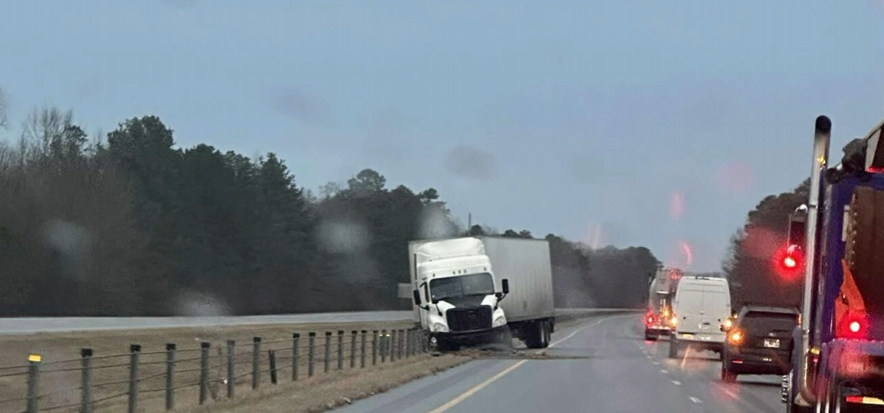
sakau2007 replied to BooneWX's topic in Southeastern States
two truck accidents. one on I-22 in Mississippi near New Albany... the other on I-65 near Athens, Alabama.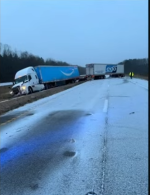
-
Southern Crippler - Get well soon Jimbo Storm Obs
sakau2007 replied to BooneWX's topic in Southeastern States
Interstate 22 at New Albany, MS - temp is 20 degrees. rough.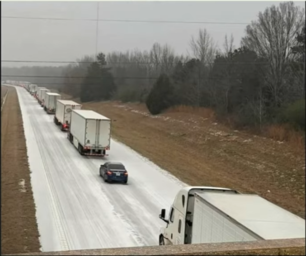
-
Southern Crippler - Get well soon Jimbo Storm Obs
sakau2007 replied to BooneWX's topic in Southeastern States
https://smartway.tn.gov/allcams?region=Memphis Memphis is cold and white. -
Southern Crippler - Get well soon Jimbo Storm Obs
sakau2007 replied to BooneWX's topic in Southeastern States
downtown little rock is snowed/iced in. 10 degrees! wow.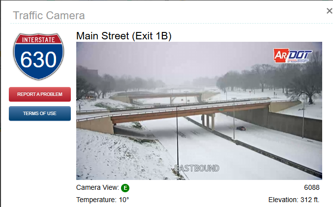
-
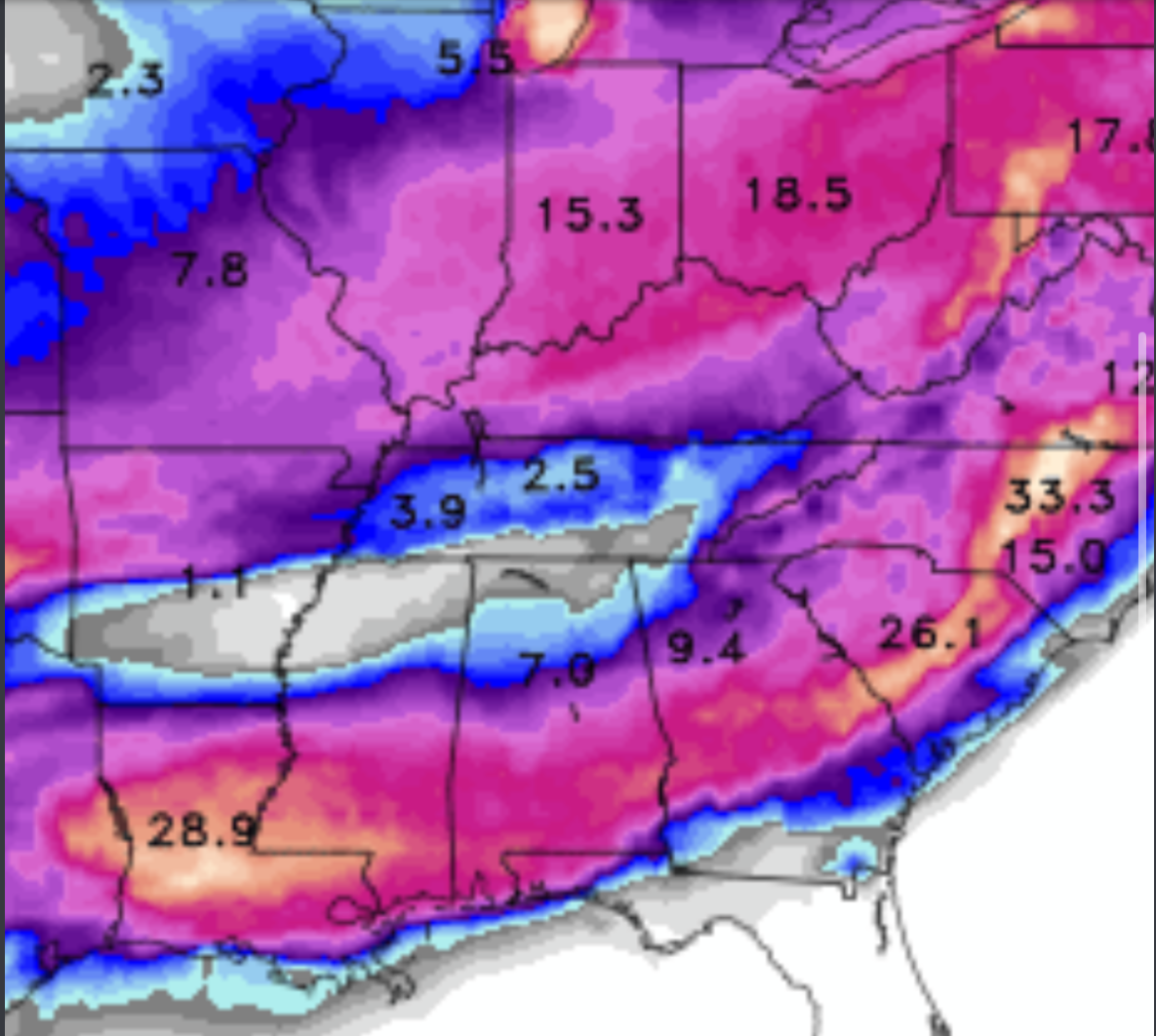
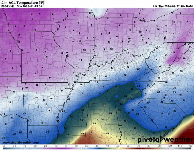
interesting, because it seems like it's actually a few degrees colder than forecasted across Arkansas/northern MS/western TN so far.
-
There's a decent glaze of ice across quite a few counties across northern AL. Seems a little colder than expected in places like Little Rock, Memphis, Tupelo, and NW AL so far. I mean, hell, there are areas around Little Rock below 10 degrees. If precip type changes to Frz Rn with it that cold at the surface, that would be wild.
-
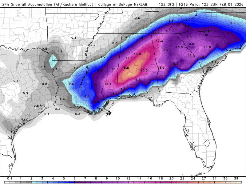
NAM definitely trending a stronger wedge deeper south and west into Georgia... but also trending a little warmer for northern Mississippi. surface thermals could definitely be a fail mode across most of MS now too.
-
the canadian is on board lol...

-
First call: Birmingham, 0 inches.
-
can we start a thread for next week's storm? those of us in Alabama have moved on
-
idk how much it changes the analog for NC.. but the 2/2/96 storm didn't have nearly as much warm air advection -- that was the most memorable ice storm of my life (and the best sledding of my life as well) we stayed in all frozen precip in Birmingham.... whereas this time around, it looks like we could reach 60 degrees, and there could be a changeover to just rain well into TN if not KY.
-
what a bummer for the ski resorts. a chance to get several feet of good snow and they will get little to nothing? oof.
-
what do you guys think will happen in the smokey mountains and in places like boone? ordinarily, they squeeze out more snow but because of the warm layer, might the higher peaks be at or above freezing for most of the event, making it an odd situation where the smokey mountains are all rain while NE GA and upstate SC are icy?
-
a decent bit will be lost to sublimation.
-
i blame myself. will i ever learn to stop getting invested in winter storms more than 48 hours out? i was always on the border of a serious ice storm and just a cold rain... but now... temps could soar into the 60s? lol. i'm no expert, but i think that could eat into ice accumulations.
-
that’s kinda my point. i get the idea of friction reducing wind speed… but the reality is this thing is now well inland... and i’ll partially buy the reasoning that equipment fails (although over the last decade the number of storm chasers putting themselves in the worst areas makes me even somewhat skeptical of that) but what about now? where are 100+ mph sustained winds occurring? i doubt anywhere. gusts into the 80s or 90s? sure. sustained at 105 after 9pm? i doubt.
-
I'm pretty sure there has not been a high risk issued in the history of high risks where people think we will be debating the busts in 24 hours time. That's kinda the point of the high risk -- the numbers are maxed out so the high risk goes up. Just my .02. I'm still not completely overwhelmed by this setup, but the very high significant tornado index numbers across parts of AL/TN are certainly eyebrow raising. I'll be surprised if we make it through today without an EF3 somewhere.