-
Posts
4,228 -
Joined
-
Last visited
Content Type
Profiles
Blogs
Forums
American Weather
Media Demo
Store
Gallery
Posts posted by jojo762
-
-
51 minutes ago, DanLarsen34 said:
Not comparing these two setups when I say this, but I believe we had a similar issue in modeling in the the build-up to 4-14-2012 where some models were initiating no convection align the dry line despite minimal capping.
Yes, the NAM wasn't convecting the night/days leading up to that event... HOWEVER, it was extremely obvious that we were going to get storms that day given the dynamics at play, etc. I feel as though Tuesday is much less obvious -- however, the NAM is absolutely out to lunch showing zero CI along the dryline, esp in Oklahoma. Some of this morning's 12z NAM soundings in KS had a lot of CINh, which obviously worries me... But when all is said and done I think we get a fairly sizable outbreak of severe storms on Tuesday. Tornado threat is tricky despite pretty looking colors on the parameter maps, because we will likely have at least some residual CINh -- meaning storms could potentially struggle to maintain surface-based status.
I'm pretty bullish overall on Tuesday. It *will* be a day we all remember for a while -- but for what reason? Epic cap bust or substantial tornado outbreak are both on the table.-
 3
3
-
 1
1
-
-
3 minutes ago, Doc Jon said:
6-7 feet of water over I-10 at I-55 interchange.
-
7 minutes ago, Will - Rutgers said:
I’m seeing 105?
SUMMARY OF 1100 PM CDT...0400 UTC...INFORMATION
----------------------------------------------
LOCATION...30.4N 90.7W
ABOUT 5 MI...10 KM W OF KILLIAN LOUISIANA
ABOUT 30 MI...50 KM ESE OF BATON ROUGE LOUISIANA
ABOUT 45 MI...70 KM NW OF NEW ORLEANS LOUISIANA
MAXIMUM SUSTAINED WINDS...95 MPH...155 KM/H
PRESENT MOVEMENT...NW OR 340 DEGREES AT 9 MPH...15 KM/H
MINIMUM CENTRAL PRESSURE...960 MB...28.35 INCHES
-
 1
1
-
-
What on earth is happening...
-
 5
5
-
-
10 minutes ago, MattPetrulli said:
This has to be a record for strongest sustained, and gusting winds RECORDED in a hurricane... right?
-
 3
3
-
-
2 minutes ago, Ed, snow and hurricane fan said:
It could be rain, but the second floor window flooding rescues in Houston/Harvey didn't start the first day with the first foot of rain. Not claiming to be any kind of expert in rainfall runoff, but roof top rescues from a foot of rain, that doesn't seem likely in fairly flat terrain.
Roof top rescues are happing in Laplace, not NOLA. Laplace is getting hammered by both surge and rain-induced flash flooding.
-
 5
5
-
-
9 minutes ago, Doc Jon said:
2900 block of Donner drive in New Orleans flooded, water rising.
Looks like there is some sort of small stream that runs parallel to Donner Dr in NOLA. It looks tiny, so the fact that they're reporting flooding from it is pretty astonishing.
-
6 minutes ago, jacindc said:
WWL reporter showing that I-10 near the 610 split in Metarie is covered with water. He sounds pretty disturbed by it, worried about where the water would be coming from.
-
1 minute ago, North Balti Zen said:
More details on the power issues...
That is likely going to take weeks to fix.
-
 3
3
-
-
Looks like 1st and 2nd hand reports on twitter indicate the flooding is pretty much as serious as the Jefferson Parish scanner traffic about roof-top rescues would indicate...
-
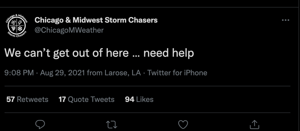
This might be a little disruptive to more important things happening... But what a damn child. He begs for help, as if he's in imminent danger... Now he's responding to backlash on twitter for putting himself in a piss poor position? Some emergency, huh?
-
 1
1
-
 2
2
-
-
Rather apparent that catastrophic, potentially deadly flooding is taking place in Laplace.
-
 1
1
-
 2
2
-
-
-
1 minute ago, StormChaser4Life said:
That's CJ Lergner. That dude is a reckless idiot. He would put himself in danger in order to get footage. Most chasers played it safe and stayed away from the vulnerable surge areas but he was way south. He has no regard for other people then expects everyone to bail him out.
FWIW, believe the Jock Williams dude (the guy with the stream) is also with him... Esp given Jock's SN location being Larose, LA (same as location indicated in the tweets).
-
-
1 minute ago, hazwoper said:
Maybe. I just look at the radar and the reduction in stronger returns coming in from south of NO.
There is multiple strong feeder bands training over the FFE area... and with the system moving *slowly* north, that is not going to be changing anytime soon.
-
 1
1
-
-
3 minutes ago, Doc Jon said:
sorry, just wondering if a levee broke.
No a levee did not fail... But there is insane rainfall rates across much of the FFE area, with plenty of rain already having fell... In addition Laplace has been getting hammered by surge (see earlier videos posted). Not sure if someone posted it or not, but also saw a video on twitter of flooding in the Lakeview community in NOLA.
-
2 minutes ago, MattPetrulli said:
...FLASH FLOOD EMERGENCY FOR SOUTH SHORE AREA OF METRO NEW ORLEANS...
...FLASH FLOOD WARNING REMAINS IN EFFECT UNTIL MIDNIGHT CDT TONIGHT
FOR NORTHWESTERN JEFFERSON, SOUTHWESTERN ORLEANS, NORTHWESTERN
PLAQUEMINES, WEST CENTRAL ST. BERNARD, NORTHWESTERN ST. CHARLES AND
WEST CENTRAL ST. JOHN THE BAPTIST PARISHES...At 808 PM CDT, the public reported flash flooding across the warned
area. Between 4 and 7 inches of rain have fallen. Additional
rainfall amounts of 3 to 6 inches are possible in the warned area.
Flash flooding is already occurring.This is a FLASH FLOOD EMERGENCY for South shore area of metro New
Orleans. This is a PARTICULARLY DANGEROUS SITUATION. SEEK HIGHER
GROUND NOW!HAZARD...Life threatening flash flooding. Heavy rain producing
flash flooding.SOURCE...Public reported.
IMPACT...This is a PARTICULARLY DANGEROUS SITUATION. SEEK HIGHER
-
Just now, CoastalWx said:
This had Top end potential. Excellent outflow, moist environment, low shear, high octane fuel. Boom. And a lot of guidance showed this potential.
No doubt that it had the potential but still 150mph felt lofty, at the time IIRC it was still a 105mph storm that had been sputtering most of the day from a wind-standpoint. Great forecast.
-
2 minutes ago, CoastalWx said:
I like that comment from @LakeEffectKing yesterday. This will be 140mph morning or earlier. LOL. Made me laugh considering what happened overnight.
Didnt he verbatim say this would be a 150mph ‘cane before landfall? I honestly thought the dude was nuts at the time — in spite of obviously being one of the more veteran/knowledgeable posters on the forum, from my experience.
-
 1
1
-
-
Well that’s umm… bad with MANY more hours of upstream flow/surge. Does anyone happen to know or have access to data about the levees on each side of the Mississippi? (Eg, how much higher is the levee on the NOLA side vs the eastern side that has been overtopped?)
-
1 minute ago, Moderately Unstable said:
I would frankly be surprised if he's even hit 100. Lots of stuff starts flying once you hit triple digit winds. It's very much "obvious". One easy way to tell--the deciduous trees he's been filming are not toppling over, or even swaying wildly. Those tree types don't handle wind well--palm trees evolved the way they did specifically to handle wind. He's barely seen hurricane strength yet. He will, and he will quickly learn what real strong winds actually look like.
Honestly I probably should not have tried to even rationalize what he's been saying as you are correct that he almost definitely has not even hit triple digits yet -- as evidenced by that ASOS ob station.
-
1 minute ago, mob1 said:
Golden Meadow is about to take it on the chin, Mark Sudduth set up a camera there as well.
This is where the gate (on Hwy 1) is located for the levee that protects most of the Hwy 1 corridor. Moment of reckoning.
-
Unsurprisingly, Simon Brewer and Juston Drake are in superb position to get hammered.
-
 1
1
-


April 10th - April 13th(?) Severe Weather, Moderate risk in place for Iowa today
in Central/Western States
Posted
The 00z HRRR was (predictably?) rough for KS/OK. Big time throwback to the 4/9/11 Mapleton, IA tornado though with a lone-ranger INVOF the triple point.
HRRR soundings I pulled from KS all exhibited fairly minimal CINh, so I'm honestly curious what exactly we're missing as far as the model not initiating...
EDIT: Besides the fact that the wave is probably just a *touch* too far west...