

WEATHER53
-
Posts
7,715 -
Joined
-
Last visited
Content Type
Profiles
Blogs
Forums
American Weather
Media Demo
Store
Gallery
Posts posted by WEATHER53
-
-
25 minutes ago, EastCoast NPZ said:
With light snow it will. During Jan 6 storm with light snow at 29F, plowed sections of parking lots and streets and my shoveled sidewalks and driveway melted that afternoon prior to the late afternoon/evening ULL snow. Granted, I had episodes of filtered sunlight. But if we get a .3" qpf storm and warm ground leading in, my expectations are very low. But, maybe I'll be pleasantly surprised by qpf rates for once.
Can you send this to me again Sunday at 6pm and we will see how it turned out ?
-
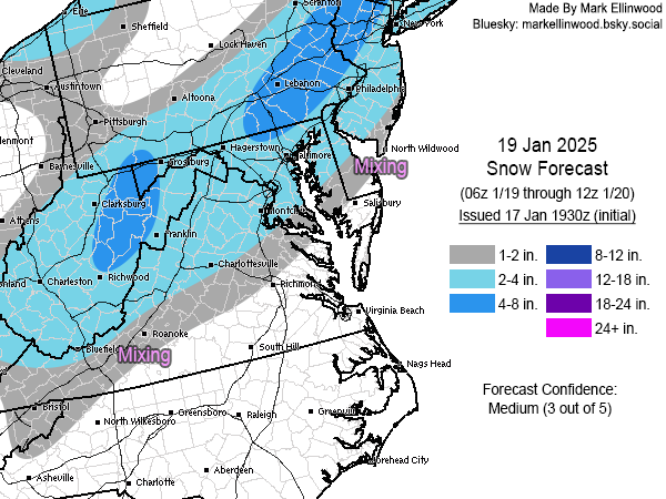
22 minutes ago, Ellinwood said:
Snow forecast for Sunday. South side dealing with marginal surface temps and there could be accumulation issues if the rates aren't good enough during the daylight hours. QPF also a concern across the whole region as it will depend on coastal strength and track.
How much liquid do you think we will have left after temps begin their dramatic drop?
-
20 minutes ago, EastCoast NPZ said:
With light snow it will. During Jan 6 storm with light snow at 29F, plowed sections of parking lots and streets and my shoveled sidewalks and driveway melted that afternoon prior to the late afternoon/evening ULL snow. Granted, I had episodes of filtered sunlight. But if we get a .3" qpf storm and warm ground leading in, my expectations are very low. But, maybe I'll be pleasantly surprised by qpf rates for once.
Because of the warmth preceding.
-
25 minutes ago, WxUSAF said:
Right now think I’d go:
DC/PG/I66 corridor/Rt50 corridor/2-4”
Baltimore/HoCo/HarCo/MoCo/Loudon 3-5”
Frederick/Carroll/N Balt County/York PA 4-8”
Percentage wise for outside the beltway I’ll go
0-2”:10%
2-4”-50%
4-6”-25%
6”+-15%-
 1
1
-
-
1 hour ago, EastCoast NPZ said:
Not to mention this is falling in the afternoon with max solar insolation. .3" QPF, even if we get it, is going to be a very minor event. Honestly, not getting the enthusiasm for this system. But, as always, hoping for the best.
The sun is still in the off position and 30-32 with steady snow won’t fritter away
-
2 minutes ago, DDweatherman said:
After the first couple hours when the low passes east of our longitude, I'd bet ratios would improve. That being said, 850's aren't necessarily bad for ratios better than 10:1.
Think we will go from like 30-32 at 3pm ish Sunday to 20-25 by 6/7 pm so that will boost ratios and I’m even going to throw out some squalliness as possible
-
3 minutes ago, Ji said:
.3 inches is dry. Not sure why everyone is taking shots at me.
It don’t feel so great do it???
-
35 minutes ago, Terpeast said:
I’d take the under on kuchera ratios along i-95 and just NW, but could be right for the elevations.
Feeling 2-4” areawide, 3-6+ well nw (cacotins and mount psu, m/d line)
These high ratios probably result of bitter cold air beginning to pour in
-
12 minutes ago, psuhoffman said:
In a meeting, cant do analysis but this is the money panel just came out

-7 850s
-
2
-
-
1 hour ago, TSSN+ said:
Why is there still this much difference 48 and less hours out form a storm is getting frustrating.
CAB
-
1 hour ago, stormtracker said:
You couldn't wait to pull that one out, could you?

But yeah...it's annoying, but If the Euro holds, I dunno man
What does genius AI say?
-
1 hour ago, stormtracker said:
Read up a few posts friend.
Hey Ra**y the Dr King switch is a fine tribute
-
1
-
-
The onset of the cold coincides with the great onslaught if 1994. 8 for a high at DCA and around zero by dark.
1982 and 85 put up impressive numbers same time alsoHow our arctic express looking ?
-
4 minutes ago, Deck Pic said:
no..league would never allow it. Plus Quinn will probably coach horribly. It's a good oppty for the league to highlight Jayden. primetime is nice slot
Man they have fairy dust on them . 5-0 on last play of game
-
7 minutes ago, 87storms said:
Sometimes it just takes an open mind. I thought I hated oysters until I ate fried oysters last night.And after many more frieds then try a rawbie!
-
13 minutes ago, Deck Pic said:
same. If my forecast is 3-6"" and I get 3.2", I'm usually not that bummed
DP
it looks like the snow say after 3pm Sunday would fall in rapidly decreasing temps to around 20 before ending Monday. Thats unusually cold so might not 0.2” lq produce 3”+ rather than our more traditional 1-2”
-
2
-
-
4 minutes ago, stormtracker said:
Light to moderate snow DC and southwest at 15z
18z moderate for all
We are a snow town. It’s like Garret Co has moved in
-
3
-
-
26 minutes ago, Ji said:
so you finally found a model you like?
I may now be forever changed. It contains elements I have thought about for years. It may be onto something right now as we are in snow mode until we aren’t. That kind of historical data including even offbeat outcomes will have an effect The joy of me shutting up about models may not be far away.
-
1
-
 5
5
-
-
2 hours ago, mitchnick said:
Believe it or not.......AI WETTER!
Start with this 6 hour panel.
I believe
-
2 hours ago, stormtracker said:
Might have to give AI some credence now.
It’s ability to go back to some analog historic data outcomes and blend that in however is best is real and real good.
-
Solid dusting. Not quite 0.25” but not much less than
-
1
-
-
Light steady snow began 5:50pm and some decent flake size
-
1
-
-
Steady snow in Frederick but not Kemp Mill . 35.5 for a high and 34.5 now KM
-
39 minutes ago, Steve25 said:
The overall look is that we drop to around 20 degrees as the sun rises Monday morning, really don't rise at all during the day Monday. Then mid-teens for highs both Tuesday and Wednesday, with lows in the single digits.
Likely at least 72 consecutive hours under 20 degrees.
If that happens I think that would be top 5 coldest snaps since 1990
2018 I think and some I don’t have notes about right now, Feb 2007 I think snd then epic 1994
-
1
-

1/19 - The Weekend Roulette Wheel Thing
in Mid Atlantic
Posted
I got a feeling that there will be some pushback on AI model because it’s going to display the consistency of forecasting that all the rest never have . Taking away the ever changing unpredictability won’t be well received by some because the necessity of deciphering the situation will decrease via the consistency of the AI .