

87storms
-
Posts
7,960 -
Joined
-
Last visited
Content Type
Profiles
Blogs
Forums
American Weather
Media Demo
Store
Gallery
Posts posted by 87storms
-
-
B- in Frederick. Had several systems of 2-4”, some healthy squalls, and a couple of cosmetic events sprinkled in with a bit of freezing rain. We’ve had worse, but it’s time for a 6-10” snowfall.
-
 1
1
-
-
The movement of air settled a bit towards sunset which helped my three point percentage. I’m actually starting to crave a filthy, stagnant summertime Bermuda high. We’re due for one of those. I’m all in on a humidity-laden summer with high cape, afternoon storms.
-
 1
1
-
-
Issa wrap. Hopefully next year we can snag an El Niño and finally break out of this drought-producing, nw flow. I mean, the lack of a substantial snow in the northern tier is just getting weird at this point. I’m ready for spring and a reshuffle of the overall pattern.
-
2
-
-
Crazy amounts of dust caused mud spots on cars this morning.

Is this in Maryland, too? I actually just noticed dirt spots all over my car. We did have some light rain around here last night. -
18z AI tells 12z to hold my beer

Way too late in the season for cosmetic snow. March needs to be a winter storm warning minimum. -
Looks like a miracle stretch of weather incoming.
-
Finally see a few open spots in the sky (I'll call it mostly cloudy), NWS had 'sunny' in forecast all day lol. Currently 34.8/22.9 after a 38.4 high with light flurries most of day. Highest wind was 49 mph at 1:18 pm.
One of the more common forecast errors is predicting sun after a storm passage. We’re generally miserable at that because there always seems to be too much residual moisture as the cold air filters in.-
1
-
-
Wind was really cranking for a bit last night. My balcony furniture is all huddled up in a corner.
-
Pretty remarkable CAM agreement on an intense line rolling through the area in the early afternoon tomorrow. (The NAM Nest is a bit later than any other guidance, but it has a notorious slow bias on convective timing.) The reflectivities look amazing, but is there really any severe potential with it in the DC area? The wind fields are amazing, and if we had even 500 j/kg of sfc-based cape, we'd be looking at widespread damaging winds and QLCS tornadoes. But there really isn't any instability shown by any model. Maybe the HRRR squeezes out 50-100 j/kg, but it looks warmer than most other guidance. So, I have to wonder if this will be just a short period of torrential rain followed by stratiform. Before I totally poo-poo the threat, however, it's worth noting that sometimes the incredible shear and overall dynamics can drive severe weather with a forced line in an environment with basically no cape, so I won't rule out a damaging event with an isolated brief pinup, but I don't think that it's likely.
The better environment actually establishes itself over northern VA and areas to the north and northwest in the evening hours, as the very cold air aloft arrives, steeping lapse rates. Go look at sfc-based cape fields for the early evening hours. The values aren't awesome, but they're notably higher than during the early afternoon event. Wind fields are still decent, so any cells would likely be supercellular have hail and wind potential. Unfortunately, the upper system arrives just a bit too late, and nighttime sfc cooling with reduce the potential as the evening goes on. The best severe threat with this round will be over eastern WV, northwestern VA, and up into PA. Maybe an isolated cell can pop across the DC metro area, and it would have severe potential if it did, but the threat appears low there at this time.
Seems like things played out this way. Little more energy with the last round, but the evening arrival may have lessened the impact -
Few rumbles with this latest round.
-
3 hours ago, Ji said:
except when we need it to come through
That would still make it a step ahead lol
-
1 minute ago, EABiker said:
My son and I road between a mother and 3 cubs on the Blue Trail at the Shed. I stopped as Mama and TWO of the cubs ran over the hill, but the third cub climbed a tree and started crying not 20 feet away from me. I never said, " No no no no no! " with such conviction!
Damn, that's a dicey situation lol. Mama bears are no joke.
Catoctin blue is legit...I like riding the Blue to VW/Knucklebuster loop, and when I feel like torturing myself I'll ride up Three Saws and down Catovid. Fun trails there...my bike is currently in the shop (spring cleaning).
-
Top shelf downpour in progress by March standards.
-
3
-
-
1 minute ago, dailylurker said:
Hiking with rain gear. Just sprinkles so far. The wind is ripping in Crownsville. I've been hearing dead trees coming down. Kinda scary but it's not my first time.
That's always a fun sound when biking lol. My head is also on a swivel when biking the watershed ever since I saw a black bear scurry across Hamburg road.
-
 1
1
-
-
Having a southerly component to the flow is helping Frederick so far today. Minimal downsloping issues. Decent line about to move through.
-
GFS truly does seem to be behind the Euro by a day when we get to the 5-6+ day range. I don't know what/how they feed the Euro, but it's just the goat of the models at this point.
-
Nice rain here...nothing too heavy. Wind is there, but nothing too crazy yet. Loving the humidity, though. I was getting tired of the dry weather.
-
Is everyone's lawn chair ok?
-
I’m 100% all in on an El Niño. I may need to start tracking downwelling off the Pacific Coast.
-
2
-
-
The center of the low tomorrow will be moving through Chicago. We will get our breezy line of showers with a couple of rumbles of thunder and we will like it.
-
12 minutes ago, Chris78 said:
Could the weather ballons not launching from Alaska cause the Gfs to be off on a tangent? No other model is even remotely close and we're only 5-6 days away.
The euro is only 600 miles souther lol
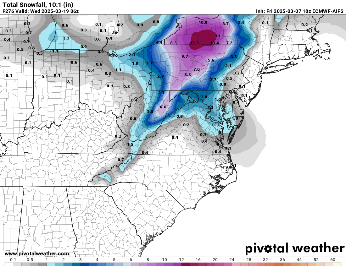
I'd love for the Gfs to be right. It dumps double digits on my yard but no way its correct.
GFS solution looks kinda weird...the system seems too amped up given the weak high pressure to the north.
-
Just now, CAPE said:
LOL I don't think I would use the last storm(fail) as an example. Objectively, they all had it wrong in unison bigtime, then backed off. I'm not going to give much credit to the one that was first, if there was one. That was a model debacle across the board.
I really have a hard time calling that last storm a fail on the level that some here imply. Pretty sure the digital snow peaked on Saturday and just about every model run after that clearly hinted that the storm could slide south. The upper level setup was always suspect and, at the end of the day, the storm took the path of least resistance with simply too much of a cold air push.
-
1
-
-
Looks like this might be the last cold morning for a while. Beautiful day on tap.
-
1
-
-
Bermuda high getting established at the end of the GFS run. Bring it.
I’m hyped-
1
-
March Discobs 2025
in Mid Atlantic
Posted
Basically, today's weather is majestic so far.