

Mailman
-
Posts
1,485 -
Joined
-
Last visited
Content Type
Profiles
Blogs
Forums
American Weather
Media Demo
Store
Gallery
Posts posted by Mailman
-
-
-
-
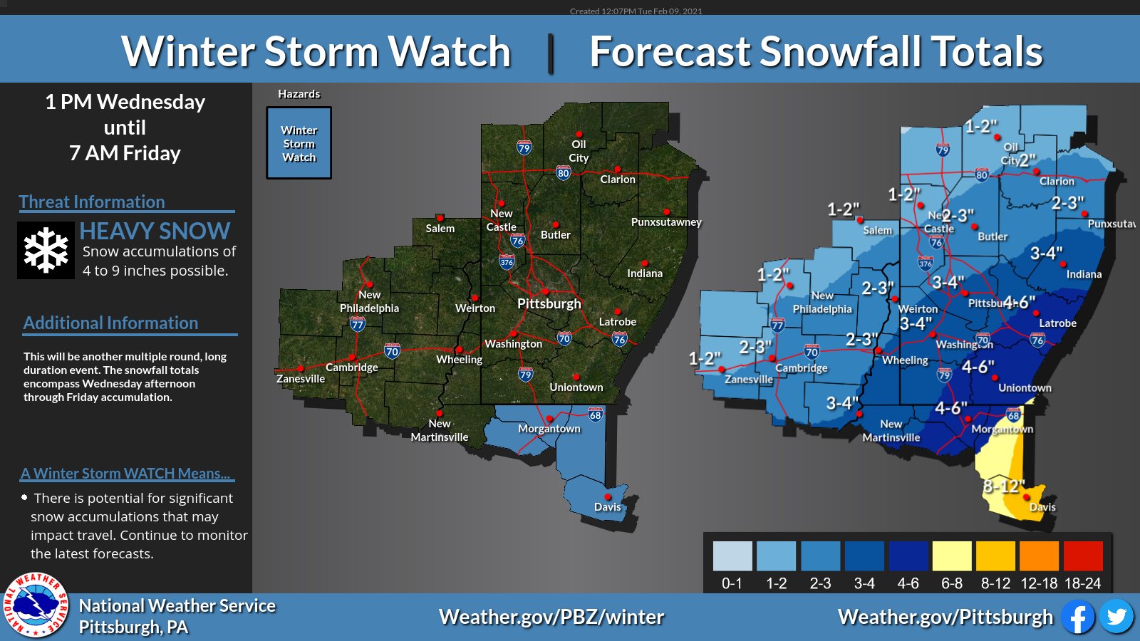
.SHORT TERM /SUNDAY NIGHT THROUGH TUESDAY NIGHT/...
A series of shortwaves withing SW flow will increase wintry precipitation
chances Monday into Tuesday as the longwave central U.S. trough axis
shifts slightly eastward. At the sfc, a low will develop and deepen
as it moves from the Mississippi Delta towards the northeast U.S.,
with cold air filtering into the region Tuesday as it moves farther
east of the Upper Ohio River Valley.

Confidence remains high in accumulating snowfall for much of the
region and the second wave late Monday into Tuesday being the more
significant punch. The combination of colder air, strong
frontogenetic forcing and jet support will help produce potentially
heavy snow around and to the north/west of Pittsburgh, a Winter
Storm Watch was issued. Additional headlines are likely for the rest
of the region as confidence increases in the timing and the type of
impacts expected.

That said, granular details for each wave remain inconsistent between
models and from run to run for both incoming waves. Among the varying
details through the event include positioning of a mid-level
frontogenetic zone; strength of ascent and associated connections to
a briefly coupled jet; strength and shifting of a baroclinic zone
southeast of Pittsburgh leading to more of a wintry mix or freezing
rain; efficiency of freezing rain accumulation; and potential dry
slotting within the SW flow reducing accumulation efficiency.

Increasing sfc high pressure and shortwave ridging will develop in
the wake of the exiting shortwave/low Tuesday night, with single
digit temperature likely for most locations.
-
-
Canadian appears solid.
-
-
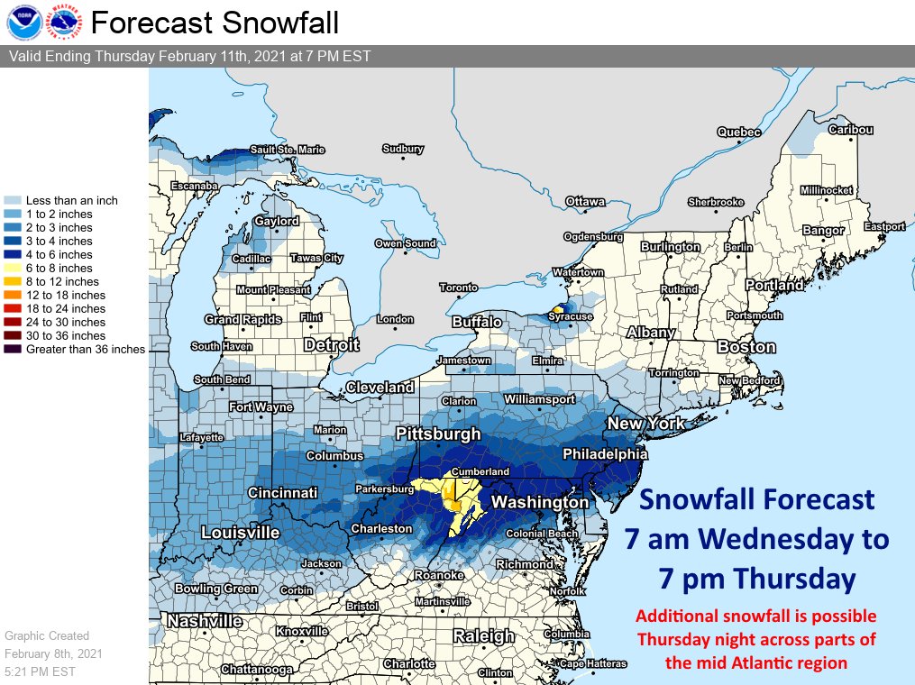
.LONG TERM /MONDAY THROUGH FRIDAY/...
The sw flow over the Upper OH is forecast to continue next week with
a series of crossing shortwaves within flow defining precip chances,
the most significant indicated for Tuesday. With plentiful boundary
layer moisture evident in relatively warmer swly flow, ascent
provided from a northern stream open wave, assisted by coupled jet
and coincident near sfc frontogenesis will prime the region with the
ingredients necessary for a widespread precipitation event on
Tuesday.

While longer range solution output varies in terms of snow
accumulations (GFS vs. ECMWF), a couple of considerations should be
noted. The first is that both models indicate the location of the
mid-level low west and north of the forecast area. With the region
located within the warm sector, this would imply the potential for a
wintry mix across portions of the region (especially south of I-80)
as warm advection hinders overall snow growth efficiency and
introduces other hazards such as sleet/freezing rain. GEFS plumes for
PIT hint at this hindrance as the operational GFS snow accumulation
output is much higher than majority of other members. Other
considerations include the anticipated quick progression of the storm
which implies a rather progressive, open wave in conjunction with
anticipated dry slotting. This translates to precipitation
diminishing rather rapidly later Tuesday. Nonetheless, hazardous
wintry weather should be anticipated, especially early Tuesday, and
headlines may be required. This will bear watching through the course
of the weekend with more updates to follow.
-
-
GFS puts me back into a nice amount of the white stuff.
-
.LONG TERM /MONDAY THROUGH THURSDAY/...
The southwest flow ovr the Upr OH is forecast to continue next week
with shortwaves within flow defining precip chc, the most
significant indicated for Tuesday. Current depictions are for the mid
level low to dig toward the Great Lakes, thus limiting snow and
overall precip potential via warm advection and dry slotting. Still,
mixed precipitation including freezing rain is expected with such a
scenario, development which will have to be monitored.
-
 1
1
-
-
GFS right where we want it 5 days out.
-
GFS did come a little east.
-
-
Canadian looks alright for next week.
-
0z GFS seems as though it's gonna deliver the goods again.
-
GFS coming in hot D6.
-
 2
2
-
-
-
A little over 2" here.
-
Coming down good here, as well.
-
-
-
-
Yeah.. it's been a pretty good winter so far, in my opinion. I could understand the negativity if we were shut out. Active pattern for the next couple weeks.
-


Western Pa / Pittsburgh area Winter Discussion ❄️☃️
in Upstate New York/Pennsylvania
Posted
18z HRRR looks good after wave 1.