

Mailman
-
Posts
1,483 -
Joined
-
Last visited
Content Type
Profiles
Blogs
Forums
American Weather
Media Demo
Store
Gallery
Posts posted by Mailman
-
-
-
Double-digits, here we come!
-
 2
2
-
-
Can't say I hold a lot of faith in the CMC; however, it has been consistent with those big totals. 12z might be the biggest yet.
-
Massive freezing rain event on the NAM.
-
Personally, I am rooting for the 18z RGEM solution to verify.
-
Canadian is a winner.
-
1
-
-
-
Seems like GFS has held serve.
-
Fries went to Buffalo to be warning coordinator.
-
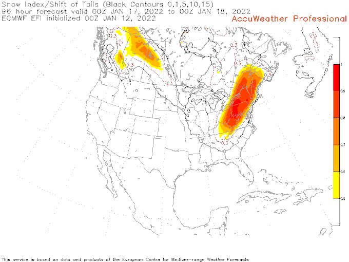
Another tool to look at. the ECMWF EFI for snow. Clearly showing the signal for heavy snow west of the I-95. This is from 00Z and like all guidance will jump around. However, you take from this that there is indeed a significant snowstorm coming.
-
1
-
-
GFS looks good.
-
2
-
-
18z GFS ended up okay. Got rid of that Mon River screwzone that showed up at 12z.
-
1
-
-
Jan '94 mixed in Morgantown, but not in PA, right?
-
-
18z GFS seems promising so far, I think.
-
Euro getting close.
-
Talk about a weenie run. Last frame has a banger, too.
-
-
Been in some decent banding down here for the last hour or so.
-
3
-
-
I remember that one. That storm was a good one.
")
-
I like clippers. They always seem to overperform here.
-
GFS is disappointing.
-
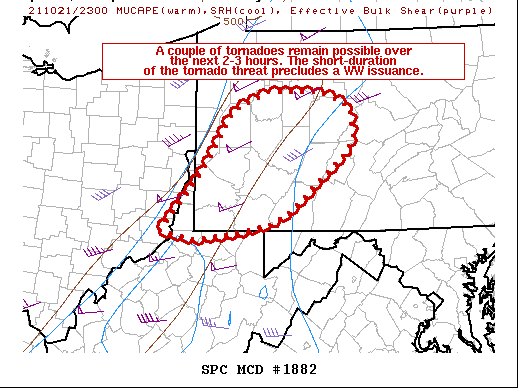
Mesoscale Discussion 1882
   NWS Storm Prediction Center Norman OK
   0656 PM CDT Thu Oct 21 2021

   Areas affected...Portions of western Pennsylvania

   Concerning...Severe potential...Watch unlikely

   Valid 212356Z - 220200Z

   Probability of Watch Issuance...20 percent

   SUMMARY...The threat for a couple of tornadoes is expected to
   persist for a couple more hours before storms weaken and the severe
   threat gradually diminishes. Given the expected short duration
   tornado threat, a Tornado Watch issuance remains unlikely.

   DISCUSSION...Multiple discrete/semi-discrete supercells continue to
   exhibit instances of strong low-level rotation, from Butler County
   PA to Ohio County WV. Multiple TDS signatures were noted with some
   of these storms in the past few minutes via KPBZ dual-polarimetric
   radar data. These storms continue to rotate within an environment
   characterized by weak buoyancy (MLCAPE barely reaching 500 J/kg
   MLCAPE), but with strong low-level shear. Specifically, PBZ VAD
   profiler data have shown consistent elongated hodographs with 200+
   0-1km SRH, with METAR observations also showing some localized
   backing of the surface winds across southwest PA. As such, storm
   organization and periods of low-level rotation/brief tornadoes will
   likely continue for a couple more hours, before boundary-layer
   stabilization results in a gradual waning of the severe threat. A
   Tornado Watch issuance is not expected.

   ..Squitieri/Dial.. 10/21/2021
-
I am really looking forward to the Ida remnants making its way up here.
-
1
-


Western PA/Pittsburgh Winter 2021/22 Discussion
in Upstate New York/Pennsylvania
Posted
Well.. at least the NAM lost the historic freezing rain scenario. Now it's a historic dry slot. lol.