

Mailman
-
Posts
1,483 -
Joined
-
Last visited
Content Type
Profiles
Blogs
Forums
American Weather
Media Demo
Store
Gallery
Posts posted by Mailman
-
-
BULLETIN - EAS ACTIVATION REQUESTED Tornado Warning National Weather Service Pittsburgh PA 158 PM EDT Thu Jul 29 2021 The National Weather Service in Pittsburgh has issued a * Tornado Warning for... South central Westmoreland County in southwestern Pennsylvania... Northeastern Fayette County in southwestern Pennsylvania... * Until 230 PM EDT. * At 158 PM EDT, a severe thunderstorm capable of producing a tornado was located 7 miles southeast of Mount Pleasant, or 10 miles northeast of Connellsville, moving southeast at 35 mph. HAZARD...Tornado. SOURCE...Radar indicated rotation. IMPACT...Flying debris will be dangerous to those caught without shelter. Mobile homes will be damaged or destroyed. Damage to roofs, windows, and vehicles will occur. Tree damage is likely. * This dangerous storm will be near... Seven Springs around 210 PM EDT. Other locations impacted by this tornadic thunderstorm include Normalville, Acme, Jones Mills, Champion, Indian Head, Donegal and Seven Springs. -

 Mesoscale Discussion 0944
   NWS Storm Prediction Center Norman OK
   1113 AM CDT Sun Jun 13 2021

   Areas affected...portions of far southeast Ohio...southwest
   Pennsylvania into northern West Virginia and northwest Virginia

   Concerning...Severe potential...Watch possible

   Valid 131613Z - 131815Z

   Probability of Watch Issuance...60 percent

   SUMMARY...The severe potential is increasing across portions of the
   Mid Atlantic. Damaging winds are the primary threat. A Severe
   Thunderstorm Watch may be needed if storms continue to intensify and
   increase in coverage.

   DISCUSSION...Multicellular clusters have recently experienced an
   uptick along the southwest flank of an ongoing MCS, on the leading
   edge of the cold pool. The MCS is propagating southward towards 80+
   F surface temperatures, with upper 60s to 70 F dewpoints
   contributing to 1000+ J/kg MLCAPE. Though only 25 kts of effective
   bulk shear are in place, and mid-level lapse rates are generally
   under 6 C/km, continued surface heating with the rich moisture in
   place is expected to support robust storm development into early
   afternoon, both ahead of the MCS cold pool and along the cold front.
   Wet downbursts and merging cold pools may support at least a few
   damaging gusts with the stronger (albeit shorter lived)
   multicellular clusters. Damaging gust potential may be high enough
   to warrant the issuance of a Severe Thunderstorm Watch over the next
   couple of hours.

   ..Squitieri/Grams.. 06/13/2021
-
 1
1
-
-

Mesoscale Discussion 0494
   NWS Storm Prediction Center Norman OK
   0147 PM CDT Mon May 03 2021

   Areas affected...portions of southern and eastern Ohio into West
   Virginia and southwestern Pennsylvania

   Concerning...Severe potential...Watch unlikely

   Valid 031847Z - 032045Z

   Probability of Watch Issuance...5 percent

   SUMMARY...A couple of the stronger storms may pose a localized
   severe risk through the afternoon hours. A damaging gust or two are
   possible and a brief tornado cannot be completely ruled out. Given
   the sparse nature of the severe threat, a WW issuance is not
   anticipated.

   DISCUSSION...Convection has gradually deepened and become more
   widespread across portions of the Ohio Valley as a mid-level vort
   max traverses the region. Pockets of insolation have allowed for
   marginal destabilization of the boundary layer, with around 250-400
   J/kg MLCAPE currently realized (per latest Mesoanalysis). 18Z PBZ
   and RLX VWPs depict considerable veering of the sfc-500 m winds,
   with modest 0-3km speed shear all contributing to 150-300 m2/s2
   0-3km SRH, with 0-1km SRH values occasionally exceeding 200 m2/s2.
   Nonetheless, upper support is expected to remain modest, with low
   and mid-level lapse rates likely to remain below 6.5 C/km across
   most locations. While the favorable shear environment would support
   a damaging gust or a brief tornado with a stronger storm, the
   marginal instability is expected to limit the severe threat. Given
   the very sparse and brief nature of any severe threat that can
   materialize, a WW issuance is not expected.

   ..Squitieri/Grams.. 05/03/2021
-
Hopefully a lot of 90 degree days in the summer.
-
1
-
-
Only a few flurries here this evening.
Cancelled my Pivotal Weather sub today. Bring on the 60's and 70's!
-
 1
1
-
-
Starting to come down nicely here.
-
-
-
-
GFS holds serve for late week.
-
I went out and didn't fall. So...
-
18z GFS all snow for Thursday-Friday!
-
2
-
-
30 and rain here.
-

Mesoscale Discussion 0091
   NWS Storm Prediction Center Norman OK
   0144 PM CST Mon Feb 15 2021

   Areas affected...northeastern Kentucky...southern/eastern
   Ohio...western/central Pennsylvania...northern West Virginia

   Concerning...Freezing rain

   Valid 151944Z - 160145Z

   SUMMARY...Precipitation will expand from southwest to northeast
   across the discussion area.  0.05 to 0.10 inch per 3-hour
   accumulations of freezing rain are expected.

   DISCUSSION...Radar mosaic imagery continues to indicate an expanding
   precipitation shield across the majority of the state of Kentucky
   atop a shallow, sub-freezing airmass.  The precipitation continues
   to outpace northeastward-movement of most model guidance outside of
   certain CAMS (Nam3, HRRR).  These CAMS indicate continued
   northeastward progression of icing (freezing rain and some sleet)
   into Ohio/northern West Virginia over the next hour or so and
   southwestern Pennsylvania after around 22Z or so.  Upstream
   observations have indicated localized precipitation rates ranging as
   high as 0.05 to 0.10 inch per hour in heavier bands/convective
   elements, and the expectation is that this will continue with
   northeastward extent across the discussion area over the next 6
   hours.  At least 3-6 hours of icing is expected areawide.
   Additionally, a few areas of sleet (or even snow) are expected to
   mix in with freezing rain - especially across the northern extent of
   the discussion area where deeper cold air is present.

   ..Cook.. 02/15/2021
-
1
-
-
Euro is good for late week.
")
-
-
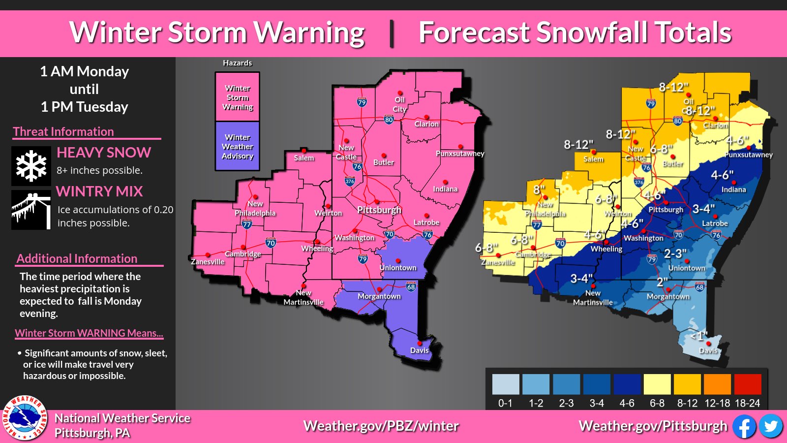
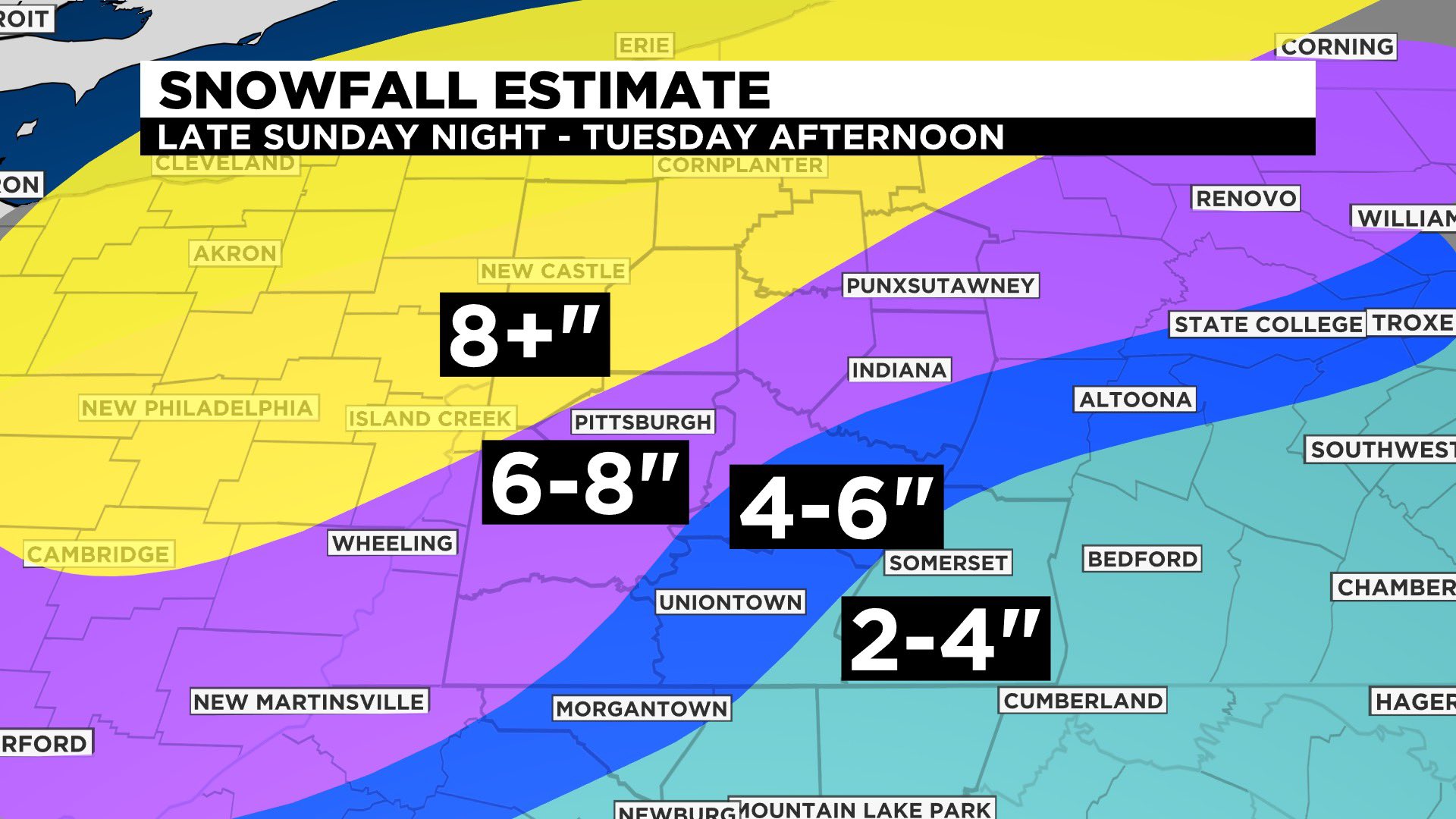
.SHORT TERM /MONDAY THROUGH TUESDAY NIGHT/...
A prolonged period of wintry impacts is expected Monday into Tuesday
as a series of shortwaves within southwest flow move across the Upper
Ohio River Valley. The first, weaker wave will see spread mainly snow
over the area Monday morning, with precipitation enhancements north
and west of Pittsburgh due to a strengthening upper jet and strong
frontogenesis stretching from SW to NE OH. Slight warm advection will
create more of a wintry mix generally southeast of Pittsburgh.

After a very brief break late Monday aftn due to shortwave ridging,
the second and more potent shortwave will cross the region Monday
night into Tuesday. Model trends have brought the upper trough and
850mb low farther west, allowing for better warm air intrusion to the
southeast of the low. If this holds, snow will be the predominant
precipitation type along the I-80 corridor and east of I-77,
transitioning to a combo of snow/sleet/freezing rain along the I-70
corridor (including Pittsburgh) and sleet/freezing rain/rain for
northeast WV. Any shift in the 850mb low track west (east) will draw
that change over line farther northwest (southeast).

The combination of a strong, coupled jet, strong mid-level
frontogenesis, and varying but cold enough thermal profiles, have
issued a Winter Storm Warning. The warm air intrusion will likely
limit snow/ice accumulation for portions of northeast WV, thus a
Winter Weather Advisory was issued.

Precipitation will generally dissipate through the day Tuesday as the
low and sfc cold front move east of the region and a notable dry slot
develops within the wake of the exiting shortwave. Cold advection
will ensue as the longwave trough axis moves overnight Tuesday night,
dropping area temperature well below seasonal averages.
-
-
Yeah.. I deleted it. Don't know why it won't show the correct one when you paste a direct link to the graphic.
-
1
-
-
Don't shoot the messenger.

-
Ron Smiley'd...
-
1
-
-
Freezing Fog is no joke.
-
18z HRRR looks good after wave 1.

-
2
-
-


Western PA/Pittsburgh Summer Discussion 2021
in Upstate New York/Pennsylvania
Posted