

Mailman
-
Posts
1,485 -
Joined
-
Last visited
Content Type
Profiles
Blogs
Forums
American Weather
Media Demo
Store
Gallery
Posts posted by Mailman
-
-
Maybe close the calendar year out with a white Christmas.
-
 3
3
-
-
-
-
Nice to see the dry slot off to the east.
-
4
-
-
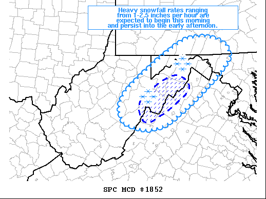
Special Weather Statement
National Weather Service Pittsburgh PA
541 PM EST Wed Dec 16 2020

PAZ007-008-014>016-021>023-029-031-073>076-170045-
Armstrong-Clarion-Fayette
Ridges-Mercer-Greene-Westmoreland-Washington-Allegheny-Indiana-
Jefferson-Butler-Venango-Westmoreland Ridges-Fayette-
541 PM EST Wed Dec 16 2020

...AN AREA OF HEAVY SNOW WILL AFFECT EAST CENTRAL MERCER...
SOUTHWESTERN VENANGO...SOUTHEASTERN WASHINGTON...BUTLER...INDIANA...
ALLEGHENY...JEFFERSON...WESTMORELAND...NORTHEASTERN GREENE...
ARMSTRONG...SOUTHERN CLARION AND FAYETTE COUNTIES...

At 539 PM EST, an area of heavy snow was located along a line
extending from 8 miles east of Slippery Rock to Monongahela.
Movement was northeast at 35 mph. Snow is accumulating rapidly
within this band of heavy snow, at 1-2 inches per hour. Use caution
when traveling, especially on interstates.

A Winter Storm Warning remains in effect until 7 AM Thursday.

Locations impacted include...
Pittsburgh...                     Penn Hills...
Mount Lebanon...                  Bethel Park...
Ross Township...                  McCandless Township...
Monroeville...                    McMurray...
Greensburg...                     McKeesport...
Indiana...                        Butler...
-
-
Big time radar return just east of 79 in southern Washington County.
-
.NEAR TERM /THROUGH THURSDAY/...
The eve update generally involved some cosmetic adjustments as
widespread snow continues in response to an encroaching upper trough
which features an impressive coupled jet structure. The resulting
divergence is generating a strengthening frontogenetically forced snow
band which will cross the I 79 corridor during the rush hour.

Otherwise expect variable snow intensity and flake size until mid
level dry slot encroachment in the predawn of Thursday. That process
with declining omega values/ascent parameters will signal the end of
accumulating snow potential. Patchy freezing drizzle will linger, but
ice accumlation greater than a trace is not anticipated in that time
frame.

No changes were made to warning and advisory headlines.
-
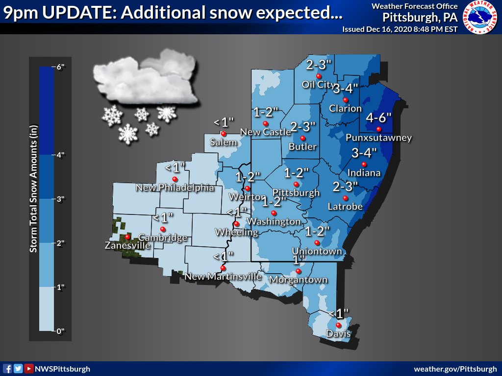
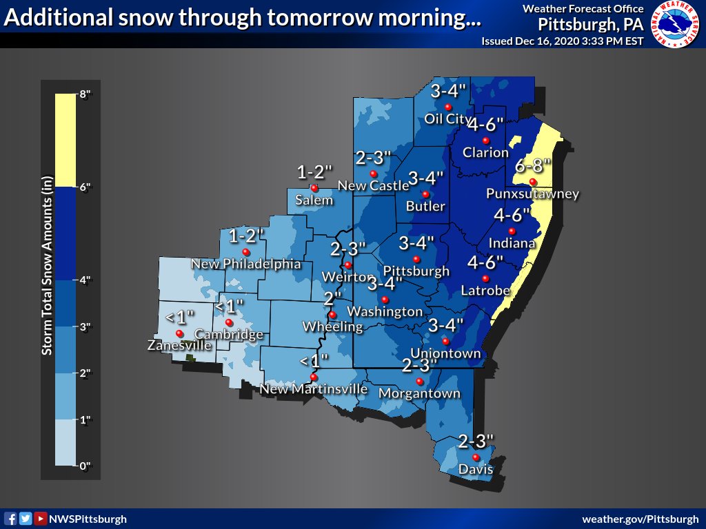
4"-ish here, as well.
-
-
Just about 2" here.
-
Rain in Morgantown.
-
Coming down good here. Already a little over 1".
-
PBZ warning coordinator said last night on their Facebook live that he expects areas north of the Mason-Dixon to stay all snow. I sure hope so.
-
4
-
-
.NEAR TERM /THROUGH THURSDAY/...
As of 14Z across the area, thE column is saturating as snow begins
to reach the ground in many locations with some accumulations being
reported in southwest OH counties and WV counties. Latest model
trends continue to set up with the highest snowfall rates setting up
across southwest PA and the WV mountains by 21Z and persisting int
the overnight hours where some 1 inch per hour and possible higher
snowfall rates continuing into the overnight hours.

Additionally, trends seem to suggest the column remaining saturated
enough through 12Z before losing the bulk of the moisture depth in
the4 atmosphere, especially in the WV counties. Thus after 12Z, we
should begin to see some freezing drizzle set up for a few hours
before this transitions over to all drizzle and rain. Temperatures
then will warm to just about freezing.
-
Things are turning a shade of white.
-
3
-
-
It has begun!
-
1
-
-
How nice. lol. Hopefully get one of these later.
-
1
-
-
It wasn't snowing in Morgantown as of 20 minutes ago.
-
-
10:1 is better for me.
")

-
1
-
-
Seems to me it is just falling in line with the other guidance finally.

-
1
-
-
How often do you really get a significant storm for the entire state?
-
4
-
-


Western Pa / Pittsburgh area Winter Discussion ❄️☃️
in Upstate New York/Pennsylvania
Posted
Still snowing. I measured 8".